Appendix - 197662 - Richfield Creek
Site Location
PSCIS crossing 197662 is located on Richfield Creek on Highway 16 approximately 30km east of Houston, BC with the highway located approximately 1km upstream from the confluence with the Bulkley River. Highway 16 is the responsibility of the Ministry of Transportation and Infrastructure.
Background
Richfield Creek drains one of the largest tributary watersheds in the upper Bulkley River. At crossing 197662, Richfield Creek is a fifth order stream with a watershed area upstream of the crossing of approximately 161.3km2. The elevation of the watershed ranges from a maximum of 1660 to 680m at PSCIS crossing 197662. Upstream of the highway, Richfield Creek is known to contain coho, chinook, steelhead, rainbow trout, longnose dace and longnose sucker (MoE 2020a). Steelhead, coho and chinook spawning has been noted in the downstream reaches of the stream with historical escapements ranging from 0-100 spawners in the reach adjacent to the Bulkley River confluence (Allen Gottesfeld, Rabnett, and Hall 2002; Hancock, Leaney-East, and Marshall 1983). Allen Gottesfeld, Rabnett, and Hall (2002) note that in some years during low flow conditions, Richfield is partially dewatered and impassable to fish. A bridge (modelled crossing 1805593) is located under the railway approximately 830m downstream of the crossing which is reported by Wilson and Rabnett (2007) to constrict the channel. Although numerous modelled crossings are located upstream of the highway an impassable waterfall is located approximately 2km upstream of the highway (pers. comm. Jonathan Van Barneveld, Forester - FLNR).
In the summer of 1998, the Nadina Community Futures Development Corporation (NCFDC) contracted the British Columbia Conservation Foundation to carry out a detailed Level 1 Fish, Fish Habitat and Riparian Assessment in the first two reaches of Richfield Creek as well as several other large Upper Bulkley River tributary streams and the Upper Bulkley mainstem. The area surveyed extended to approximately 2km upstream of the culvert where an 18m high waterfall is located (NCFDC 1998). Building on these assessments and detailed fish sampling, NCFDC (1998) developed restoration prescriptions for the lower reaches of the watershed based on the following assessment of impacts associated with landuse in the watershed:
- loss of riparian forest and soil compaction in areas used for agriculture, the powerline corridor, transportation corridors and at housing developments within the floodplain.
- loss of the shrub/herb layer and soil compaction from cattle grazing where overstory still present.
- removal of large woody debris which controls lateral channel movement and plant community distribution on the floodplain.
- loss of connectivity during low flow periods due to a lack of flow and outlet drop at the highway culverts.
- poor LWD function, channelization, high summer water temperatures, extensive eroding banks and associated sediment load, and the consistently high compaction and embeddedness of substrate.
Overall, NCFDC (1998) report that, in an unimpacted state, the first reach of Richfield Creek (including the 2.5km upstream of the culvert) is a critical and productive area for spawning and rearing particularly for coho and steelhead. They also note that the area may be an important area for chinook salmon summer rearing and summer/fall spawning habitat as it contains larger substrate, greater foraging opportunities, greater channel complexity and cooler temperatures than present in the adjacent Bulkley mainstem. The proximity of the reach to the mainstem provides easy access to overwintering habitat, mainstem rearing areas for older juvenile salmonids and options for refuge during high flow events. Detailed prescriptions for restorative measures that address noted impacts (including the construction of riffle structures to backwater the culverts) are documented in NCFDC (1998).
Overwintering studies using minnowtrapping were conducted downstream of the highway culvert between 2006 and 2009 with coho, rainbow trout/steelhead and northern pikeminnow captured. Results are summarized in Donas and Newman (2007), Donas and Newman (2008) and Donas and Newman (2010).
A water temperature monitoring station has been operational on Richfield Creek just upstream of the highway since November 2014. Results in Westcott (2020), indicate that from 2017 - 2019, mean weekly maximum temperatures in Richfield Creek were 3-5\(^\circ\)C cooler than temperatures recorded at stations located on the Upper Bulkley River mainstem. Westcott (2020) also reports that a continuous water level and temperature monitoring station is proposed on the stream.
Although in 2007, Wilson and Rabnett (2007) reported that fish passage at 197662 was not hindered by the culverts at that time the site was rated as a priority for follow up following background review and a Phase 1 assessment in 2020 indicating that the crossing was not passable according to provincial metrics and due to the presence of significant quantities of upstream habitat suitable for salmonid rearing and spawning. A map of the watershed is provided in map attachment 093L.115.
Stream Characteristics at Crossing
At the time of the survey, the two culverts under Highway 16 were un-embedded, non-backwatered and considered a barrier to upstream fish passage. The pipes were 4.2m in diameter with lengths of 24m, a culvert slope of 2%, a stream width ratio of 3 and an outlet drop of 0.2m (Table 5.50). Water temperature was 11\(^\circ\)C, pH was 7.8 and conductivity was 80uS/cm.
Stream Characteristics Downstream
The stream was surveyed downstream from the culvert for 300m (Figures 5.55 - 5.56). Overall, total cover amount was rated as moderate with undercut banks dominant. Cover was also present as small woody debris, large woody debris, deep pools, and overhanging vegetation (Table 5.51). The average channel width was 12.5m, the average wetted width was 8.8m and the average gradient was 1.5%. The dominant substrate was cobbles with gravels subdominant. There were unembedded gravels and cobbles suitable for spawning present throughout.
Immediately downstream of the culverts for approximately 80m, channel structure was simplified with no pools present and a lack of large woody debris. This is likely the result of armouring of the banks and the high flow velocities out of the crossing structure pipes. Further downstream, the channel flows through a residential area with some deep pools and glides to over 1m deep. Riparian vegetation is comprised of a narrow band of mature cottonwood forest with some areas adjacent to houses lacking trees altogether. There was evidence of large woody debris removal from the channel (chainsaw cut logs in the stream) and some stream corners were armoured with rock, concrete and old vehicles. Although some degradation of habitat was apparent, the area downstream of the crossing was rated as high high value for salmonid rearing and spawning.
Stream Characteristics Upstream
The stream was surveyed upstream from 197662 for 1200m (Figures 5.57 - 5.58). Within the area surveyed, total cover amount was rated as moderate with deep pools dominant. Cover was also present as small woody debris, large woody debris, undercut banks, and overhanging vegetation (Table 5.51). The average channel width was 13.2m, the average wetted width was 9m and the average gradient was 2.1%. The dominant substrate was gravels with cobbles subdominant. Within the area surveyed, riparian areas adjacent to both banks were used as rangeland with several cattle access points on the stream and evidence of understory shrub degradation from cattle grazing. There was a debris jam (up to 1m high in places) located just upstream of the highway. Overall, the stream had high habitat complexity including numerous pools up to 2m deep and frequent glide sections to 1m deep throughout. There were also extensive areas of gravel suitable for spawning for resident and anadromous species. Robert Hatch Creek enters the main channel approximately 400m upstream of the culvert and adjacent to Richfield Creek was comprised of beaver influenced wetland type habitat. Habitat value in the areas surveyed was rated as high for resident, fluvial and anadromous salmonid rearing and spawning.
Fish Sampling
Minnowtrapping was conducted with three traps set overnight upstream as well as downstream of the crossing. A total of 6 coho and 8 rainbow trout were captured downstream. Only rainbow trout (8 fish) were captured upstream (Table 5.53 and (Figures 5.59 - 5.60).
Table 5.52 presents preliminary fish passage modelling data for crossing 197662 with spawning and rearing habitat estimated for chinook, coho, sockeye and steelhead. Modelled estimates of the total length of salmon or steelhead habitat upstream of the crossing before potential barriers are 4.9km of potential spawning habitat and 4.9km of potential rearing habitat.
Structure Remediation and Cost Estimate
Structure replacement with a bridge (16.5m span) is recommended to provide access to the habitat located upstream of PSCIS crossing 197662. The cost of the work is estimated at $8,250,000 for a cost benefit of 0.2 linear m/$1000 and 3.2m2/$1000.
Conclusion
There is an estimated 2km of mainstem habitat upstream of crossing 197662 before an impassable falls. Habitat in the area surveyed upstream of the crossing was rated as high value for resident, fluvial and anadromous salmonid rearing/spawning. The results of temperature monitoring in Richfield Creek and the Upper Bulkley River mainstem by Westcott (2020) indicate that Rcihfield Creek (and other major tributaries to the upper Bulkley River) may have great importance for providing fish refuge from high temperatures during the hottest and driest months of the year as well as for moderation of temperatures downstream in the Upper Bulkley River. Although the ability of minnowtrapping to detect presence/absence is low when compared to other sampling techniques, the lack of coho salmon captured upstream is consistent with sampling conducted by NCFDC (1998) and adds to the weight of evidence that the culvert is preventing upstream spawner migration.
The crossing at the highway presents a barrier not only to some fry and juvenile salmonids due to the small outlet drop and high flow velocities within the pipes but also to adult salmon migrating upstream to spawn during low flows due to shallow water depths in the pipes. Future electrofishing surveys upstream and downstream of the crossing are recommended to provide presence/absence as well as density data for chinook salmon, coho salmon and other species. Highway 16 is the responsibility of the Ministry of Transportation and Infrastructure and was ranked as a high priority for proceeding to design for replacement. Restoration of riparian forests, cattle exclusion, bank stabilization and habitat complexing as per NCFDC (1998) could be considered alongside fish passage restoration activities and an assessment of the passability of the debris jam just upstream of the crossing is recommended when fish passage restoration works at the highway are initiated.
| Location and Stream Data |
|
Crossing Characteristics | – |
|---|---|---|---|
| Date | 2020-08-28 | Crossing Sub Type | Round Culvert |
| PSCIS ID | 197662 | Diameter (m) | 4.2 |
| External ID | – | Length (m) | 24 |
| Crew | KP, AI | Embedded | No |
| UTM Zone | 9 | Depth Embedded (m) | – |
| Easting | 672404.7 | Resemble Channel | No |
| Northing | 6044146 | Backwatered | No |
| Stream | Richfield Creek | Percent Backwatered | – |
| Road | Highway 16 | Fill Depth (m) | 1 |
| Road Tenure | MoTi highway | Outlet Drop (m) | 0.2 |
| Channel Width (m) | 12.5 | Outlet Pool Depth (m) | 1 |
| Stream Slope (%) | 1.5 | Inlet Drop | No |
| Beaver Activity | No | Slope (%) | 2 |
| Habitat Value | High | Valley Fill | Deep Fill |
| Final score | 29 | Barrier Result | Barrier |
| Fix type | Replace with New Open Bottom Structure | Fix Span / Diameter | 16.5 |
Photos: From top left clockwise: Road/Site Card, Barrel, Outlet, Downstream, Upstream, Inlet.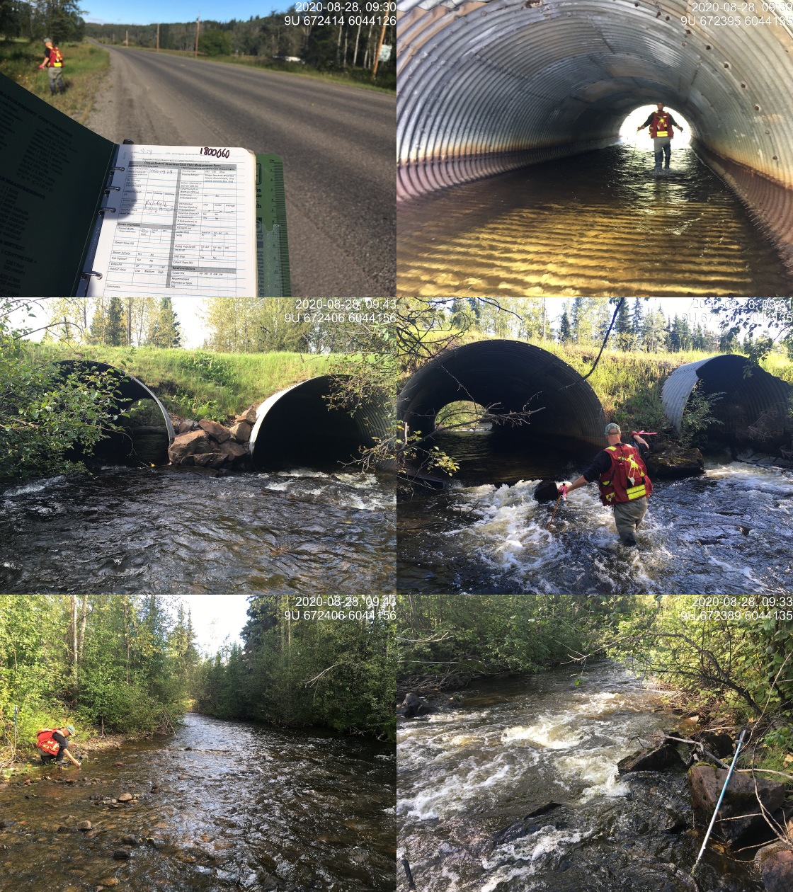
|
|||
| Comments: Habitat confirmation and minnowtrapping completed. |
| Site | Location | Length Surveyed (m) | Channel Width (m) | Wetted Width (m) | Pool Depth (m) | Gradient (%) | Total Cover | Habitat Value |
|---|---|---|---|---|---|---|---|---|
| 197662 | Upstream | 1200 | 13.2 | 9 | 0.8 | 2.1 | moderate | high |
| 197662 | Downstream | 300 | 12.5 | 8.8 | 0.8 | 1.5 | moderate | high |
| Habitat | Potential | Remediation Gain | Remediation Gain (%) |
|---|---|---|---|
| Salmon Network (km) | 65.3 | 5.1 | 8 |
| Salmon Lake Reservoir (ha) | 2.5 | 0.0 | 0 |
| Salmon Wetland (ha) | 195.2 | 0.0 | 0 |
| Steelhead Network (km) | 70.9 | 6.9 | 10 |
| Steelhead Lake Reservoir (ha) | 2.5 | 0.0 | 0 |
| Steelhead Wetland (ha) | 198.5 | 0.0 | 0 |
| CH Spawning (km) | 8.9 | 4.8 | 54 |
| CH Rearing (km) | 12.9 | 4.9 | 38 |
| CO Spawning (km) | 17.7 | 4.9 | 28 |
| CO Rearing (km) | 31.1 | 4.9 | 16 |
| CO Rearing (ha) | 104.4 | – | – |
| SK Spawning (km) | 0.0 | 0.0 | – |
| SK Rearing (km) | 0.0 | 0.0 | – |
| SK Rearing (ha) | – | – | – |
| ST Spawning (km) | 8.9 | 4.8 | 54 |
| ST Rearing (km) | 14.5 | 4.9 | 34 |
| All Spawning (km) | 17.7 | 4.9 | 28 |
| All Rearing (km) | 31.5 | 4.9 | 16 |
| All Spawning and Rearing (km) | 31.5 | 4.9 | 16 |
| * Model data is preliminary and subject to adjustments. |
| Location | Species | fry | parr | juvenile |
|---|---|---|---|---|
| Downstream | CO | 5 | 1 | 0 |
| Downstream | RB | 2 | 4 | 2 |
| Upstream | RB | 4 | 3 | 1 |
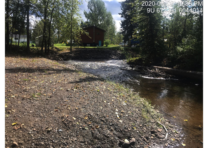
Figure 5.55: Typical habitat downstream of PSCIS crossing 197662.
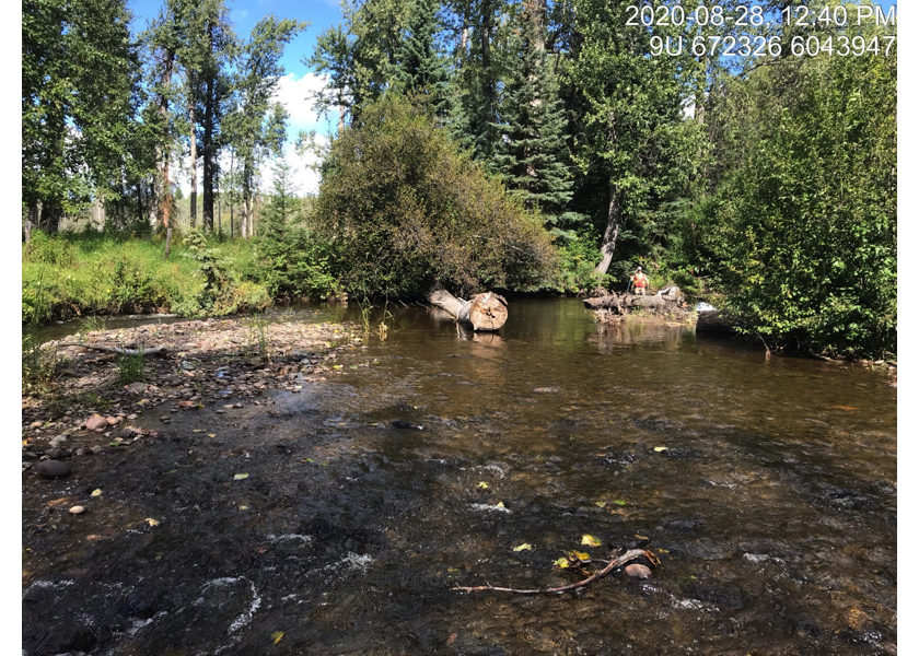
Figure 5.56: Typical habitat downstream of PSCIS crossing 197662.
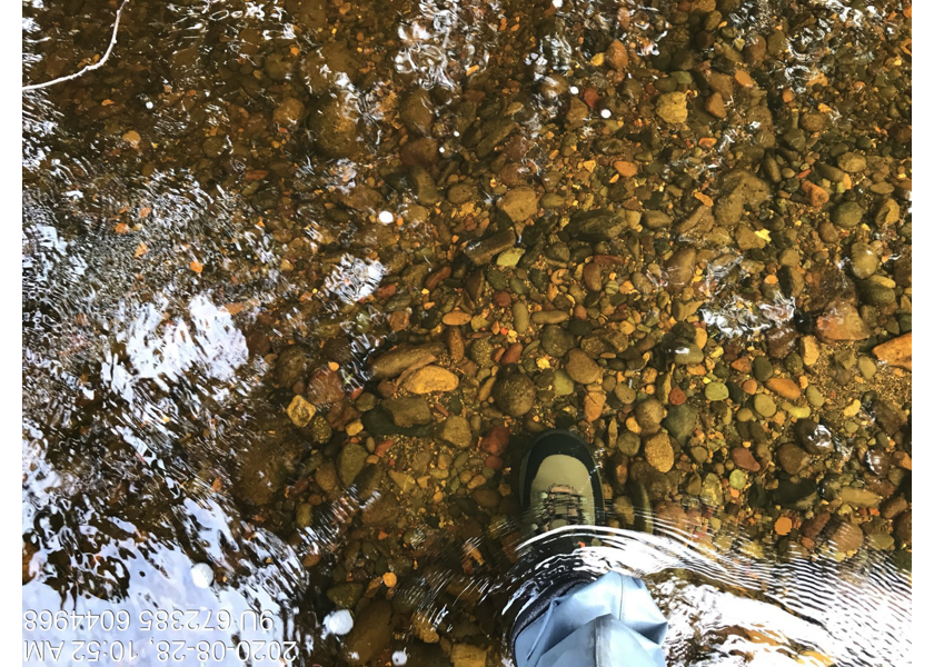
Figure 5.57: Gravel and cobble substrate upstream of PSCIS crossing 197662.
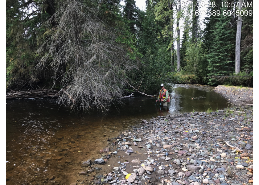
Figure 5.58: Typical habitat upstream of PSCIS crossing 197662.
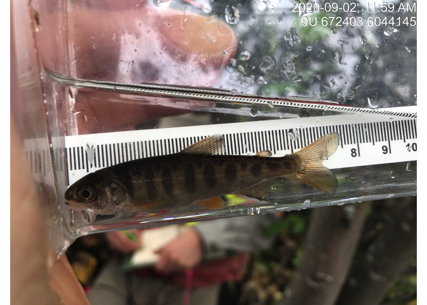
Figure 5.59: Coho captured downstream of PSCIS crossing 197662.
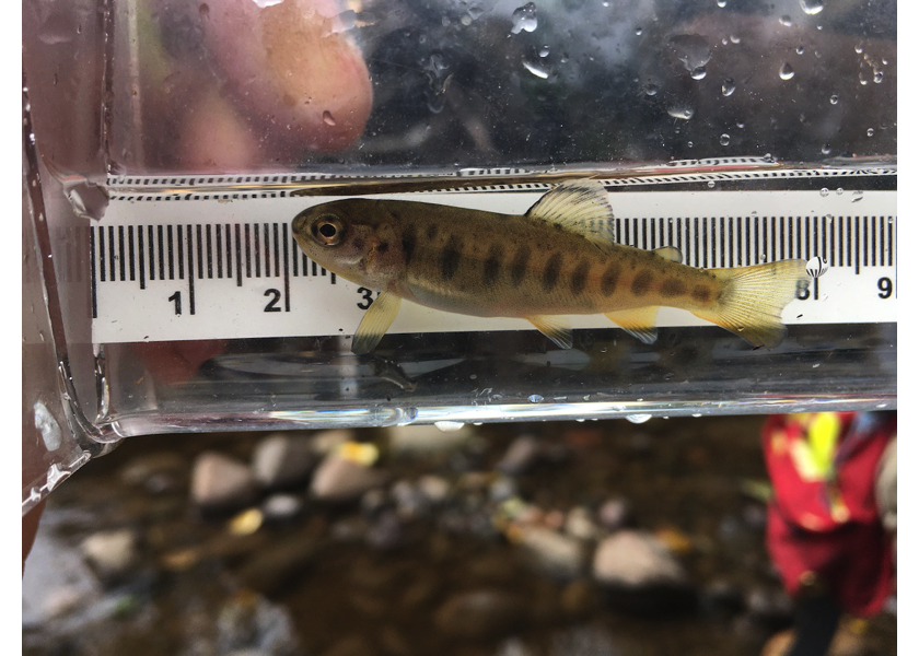
Figure 5.60: Rainbow trout captured upstream of PSCIS crossing 197662.