Appendix - 197667 & 124501 - Moan Creek
Site Location
PSCIS crossings 197667 and 124501 are located on Moan Creek approximately 5.5km south-east of Telkwa, BC. Crossing 197667 is located on the railway line and crossing 124501 is located on Lawson Road. The crossings are located approximately 475m apart from each other with the railway crossing immediately upstream (15m) from the confluence with the Bulkley River. Crossing 197667 is the responsibility of the Canadian National Railway Company (CN Rail) and Lawson Road is the responsibility of the B.C. Ministry of Transportation and Infrastructure.
Background
The Moan Creek watershed upstream of the railway is approximately 14.9km2 in area containing an estimated 1ha of lake and 15ha of wetland. The watershed elevation ranges from approximately 1350m to 530m at the railway where Moan Creek is a third order stream. Fish species documented upstream of both crossings include rainbow trout and dolly varden (MoE 2020a). Cutthroat trout have been documented in MoE (2020a) upstream of 197667 and Wilson and Rabnett (2007) report coho salmon and chinook salmon observations within the lower 500m of the stream.
Wilson and Rabnett (2007) recommended that PSCIS crossing 197667 be a high priority for remedial works to backwater the crossing by establishing a series of pools to step up to the outfall pool. In the spring of 2016, Gaboury and Smith (2016) noted that the baffled concrete box culvert (PSCIS 124501) at Lawson Road was likely a significant impediment to upstream fish passage at various discharges due to the height of the outfall drop, steep culvert slope and high water velocities. Rehabilitation designs for both crossings were prescribed by Gaboury and Smith (2016) and in both cases included the installation of downstream backwatering structures. Smith (2018) reported that in 2017, the Wet’suwet’en First Nation constructed three rock riffles and a right-bank berm to backwater the Lawson Road (124501) outlet. For the railway crossing (197667), CN Rail indicated that the design proposed was not feasible for installation, so at the time of reporting, remedial actions had not yet been implemented (pers. comm. Karla Graf, CN Environment, Manager-Environmental Impact). A map of the watershed is provided in map attachment 093L.118.
Stream Characteristics at Crossings 197667 and 124501
At the time of the survey, crossing 197667 on CN Railway was un-embedded, non-backwatered and considered a barrier to upstream fish passage according to the provincial protocol. The pipe was 2.5m in diameter with a length of 17m, a culvert slope of 4%, a stream width ratio of 1.5 and an outlet drop of 0.58m (Table 5.67).
Crossing 124501 on Lawson Road was embedded and non-backwatered and although it was ranked as a barrier to upstream fish passage, we considered it passable for adult salmonids (resident and anadromous). The concrete box culvert containing baffles was 1.6m in width with a length of 25m, a culvert slope of 6%, a stream width ratio of 2.8 and an outlet drop of 0.3m (Table 5.68). Water temperature was 9\(^\circ\)C, pH was 8 and conductivity was 86uS/cm.
Stream Characteristics Downstream of 197667
The Bulkley River is located approximately 30m downstream of the outlet of 197667.
Stream Characteristics Upstream of 197667 and downstream of 124501
The stream was surveyed upstream from 197667 for 450m to 124501 (Figures 5.78 - 5.79). Within the area surveyed, total cover amount was rated as moderate with undercut banks dominant. Cover was also present as small woody debris, large woody debris, and overhanging vegetation (Table 5.69). The average channel width was 4.5m, the average wetted width was 2.8m and the average gradient was 4.5%. There were pockets of gravels and small cobbles suitable for resident and anadromous salmonid spawning present throughout the area surveyed. Habitat was rated as high value for salmonid rearing and spawning.
Stream Characteristics Upstream of 124501
Moan Creek was surveyed upstream from 124501 for 520m (Figures 5.80 - 5.81). Within the area surveyed, total cover amount was rated as moderate with deep pools dominant. Cover was also present as small woody debris, large woody debris, boulders, undercut banks, and overhanging vegetation (Table 5.69). The average channel width was 4.8m, the average wetted width was 3.1m and the average gradient was 6.3%. There were multiple debris jams present upstream from 350m above Larson Road with heights ranging from 0.4 - 1m high. Habitat was noted as complexwith abundant gravels suitable for resident, fluvial and anadromous salmonid spawning. Habitat was rated as high value.
Table 5.70 presents preliminary fish passage modelling data for crossing 197667 with spawning and rearing habitat estimated for chinook, coho, sockeye and steelhead. Modelled estimates of the total length of salmon or steelhead habitat upstream of the crossing before potential barriers are 0.5km of potential spawning habitat and 0.5km of potential rearing habitat. Table 5.71 presents preliminary fish passage modelling data for crossing 124501 with spawning and rearing habitat estimated for chinook, coho, sockeye and steelhead. Modelled estimates of the total length of salmon or steelhead habitat upstream of the crossing before potential barriers are 0km of potential spawning habitat and 0.8km of potential rearing habitat.
Fish Sampling
Minnowtrapping was conducted upstream and downstream of 197667 with traps set in the best available habitat and left overnight. One rainbow trout was captured upstream and 4 rainbow trout were captured downstream (Table 5.72).
Structure Remediation and Cost Estimate
A cost estimate for replacing 197667 with a bridge (10m span) is $5,000,000, resulting in cost benefits of 0.7 linear m/$1000 and 3m2/$1000. Although 124501 on Lawson Road was considered passable for most species/life stages during most flows, an estimate of cost for replacement (10m span) is $500,000 resulting in cost benefits of 5.6 linear m/$1000 and 26.9m2/$1000.
Conclusion
There is 3.3km of habitat upstream of crossing 197667 and below 124501. Upstream of Lawson Road there is an additional 2.8km of habitat modelled. Habitat in the areas surveyed upstream of 197667 and 124501 was rated as high value for salmonid rearing with some habitat also suitable for spawning in both areas. Crossing 197667 on the railway was ranked as a high priority for proceeding to design for replacement. Although not quantified with current assessment protocols, the low depth of water in 197667 during moderate to low flows (such as those observed during the 2020 survey) could prevent upstream migration (particularly for larger fish such as coho and chinook salmon). Although classified as a “barrier” according to provincial metrics, crossing 124501 is embedded, baffled and without a significant outlet drop. As such, we suspect that provided conditions at the site do not change substantially from those observed during surveys, the crossing will remain passable to adult salmonids migrating upstream during most flows. The crossing was assessed as a low priority for proceeding to design for replacement.
| Location and Stream Data |
|
Crossing Characteristics | – |
|---|---|---|---|
| Date | 2020-08-31 | Crossing Sub Type | Round Culvert |
| PSCIS ID | 197667 | Diameter (m) | 2.5 |
| External ID | – | Length (m) | 17 |
| Crew | KP, AI | Embedded | No |
| UTM Zone | 9 | Depth Embedded (m) | – |
| Easting | 631092 | Resemble Channel | No |
| Northing | 6055866 | Backwatered | No |
| Stream | Moan Creek | Percent Backwatered | – |
| Road | CN Railway | Fill Depth (m) | 0.8 |
| Road Tenure | Canadian National | Outlet Drop (m) | 0.58 |
| Channel Width (m) | 3.8 | Outlet Pool Depth (m) | 0.57 |
| Stream Slope (%) | 4.5 | Inlet Drop | No |
| Beaver Activity | No | Slope (%) | 4 |
| Habitat Value | High | Valley Fill | Deep Fill |
| Final score | 39 | Barrier Result | Barrier |
| Fix type | Replace with New Open Bottom Structure | Fix Span / Diameter | 10 |
Photos: From top left clockwise: Road/Site Card, Barrel, Outlet, Downstream, Upstream, Inlet.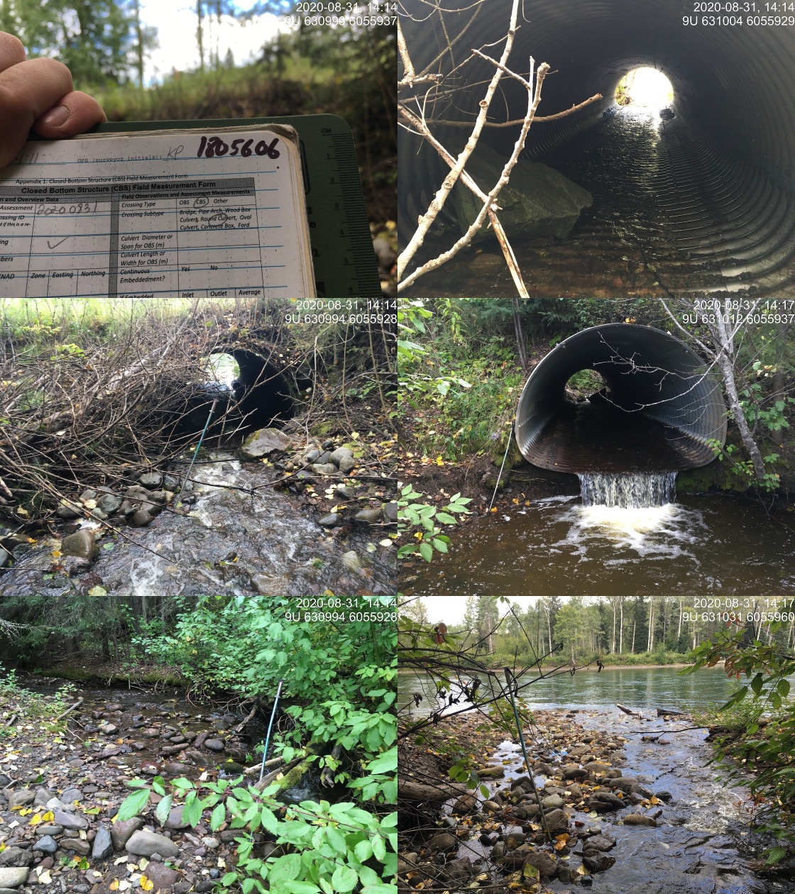
|
|||
| Comments: Approximately 17m from the outlet to the Bulkley River. |
| Location and Stream Data |
|
Crossing Characteristics | – |
|---|---|---|---|
| Date | 2020-08-31 | Crossing Sub Type | Round Culvert |
| PSCIS ID | 124501 | Diameter (m) | 1.6 |
| External ID | – | Length (m) | 25 |
| Crew | KP, AI | Embedded | Yes |
| UTM Zone | 9 | Depth Embedded (m) | 0.15 |
| Easting | 630661 | Resemble Channel | Yes |
| Northing | 6055713 | Backwatered | No |
| Stream | Moan Creek | Percent Backwatered | – |
| Road | Lawson Road | Fill Depth (m) | 1 |
| Road Tenure | MoTi resource | Outlet Drop (m) | 0.3 |
| Channel Width (m) | 4.5 | Outlet Pool Depth (m) | 0.7 |
| Stream Slope (%) | 4.5 | Inlet Drop | No |
| Beaver Activity | No | Slope (%) | 6 |
| Habitat Value | High | Valley Fill | Deep Fill |
| Final score | 34 | Barrier Result | Barrier |
| Fix type | Replace with New Open Bottom Structure | Fix Span / Diameter | 10 |
Photos: From top left clockwise: Road/Site Card, Barrel, Outlet, Downstream, Upstream, Inlet.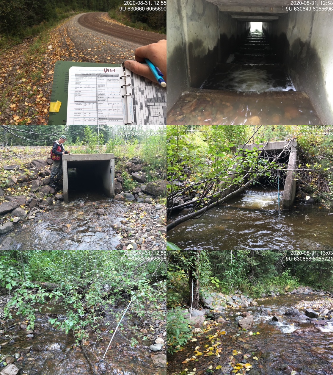
|
|||
| Comments: Fully embedded and baffled culvert. Likely passable for all salmonid adults. |
| Site | Location | Length Surveyed (m) | Channel Width (m) | Wetted Width (m) | Pool Depth (m) | Gradient (%) | Total Cover | Habitat Value |
|---|---|---|---|---|---|---|---|---|
| 124501 | Upstream | 520 | 4.8 | 3.1 | 0.4 | 6.3 | moderate | high |
| 124501 | Downstream | 450 | 4.5 | 2.8 | 0.4 | 4.5 | moderate | high |
| 197667 | Upstream | 100 | 4.5 | – | – | – | – | high |
| Habitat | Potential | Remediation Gain | Remediation Gain (%) |
|---|---|---|---|
| Salmon Network (km) | 8.0 | 0.5 | 6 |
| Salmon Lake Reservoir (ha) | – | 0.0 | – |
| Salmon Wetland (ha) | – | 0.0 | – |
| Steelhead Network (km) | 9.7 | 0.5 | 5 |
| Steelhead Lake Reservoir (ha) | – | 0.0 | – |
| Steelhead Wetland (ha) | – | 0.0 | – |
| CH Spawning (km) | 0.0 | 0.0 | – |
| CH Rearing (km) | 0.0 | 0.0 | – |
| CO Spawning (km) | 0.5 | 0.5 | 100 |
| CO Rearing (km) | 0.5 | 0.5 | 100 |
| CO Rearing (ha) | – | – | – |
| SK Spawning (km) | 0.0 | 0.0 | – |
| SK Rearing (km) | 0.0 | 0.0 | – |
| SK Rearing (ha) | – | – | – |
| ST Spawning (km) | 0.0 | 0.0 | – |
| ST Rearing (km) | 1.2 | 0.5 | 42 |
| All Spawning (km) | 0.5 | 0.5 | 100 |
| All Rearing (km) | 1.2 | 0.5 | 42 |
| All Spawning and Rearing (km) | 1.2 | 0.5 | 42 |
| * Model data is preliminary and subject to adjustments. |
| Habitat | Potential | Remediation Gain | Remediation Gain (%) |
|---|---|---|---|
| Salmon Network (km) | 7.5 | 2.8 | 37 |
| Salmon Lake Reservoir (ha) | – | 0.0 | – |
| Salmon Wetland (ha) | – | 0.0 | – |
| Steelhead Network (km) | 9.2 | 2.8 | 30 |
| Steelhead Lake Reservoir (ha) | – | 0.0 | – |
| Steelhead Wetland (ha) | – | 0.0 | – |
| CH Spawning (km) | 0.0 | 0.0 | – |
| CH Rearing (km) | 0.0 | 0.0 | – |
| CO Spawning (km) | 0.0 | 0.0 | – |
| CO Rearing (km) | 0.0 | 0.0 | – |
| CO Rearing (ha) | – | – | – |
| SK Spawning (km) | 0.0 | 0.0 | – |
| SK Rearing (km) | 0.0 | 0.0 | – |
| SK Rearing (ha) | – | – | – |
| ST Spawning (km) | 0.0 | 0.0 | – |
| ST Rearing (km) | 0.8 | 0.8 | 100 |
| All Spawning (km) | 0.0 | 0.0 | – |
| All Rearing (km) | 0.8 | 0.8 | 100 |
| All Spawning and Rearing (km) | 0.8 | 0.8 | 100 |
| * Model data is preliminary and subject to adjustments. |
| Location | Species | parr |
|---|---|---|
| Downstream | RB | 4 |
| Upstream | RB | 1 |
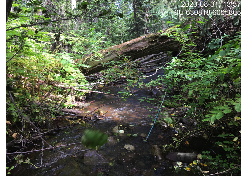
Figure 5.78: Typical habitat upstream of PSCIS crossing 197667.
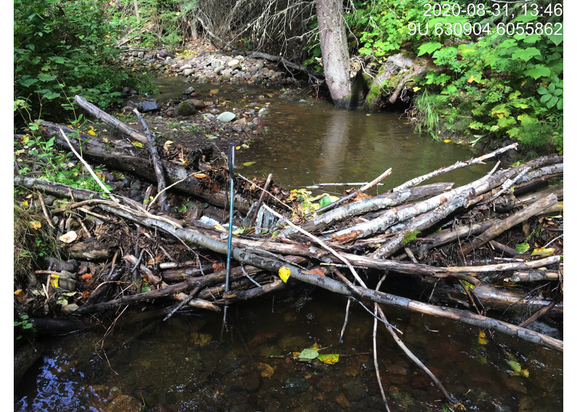
Figure 5.79: Typical habitat upstream of PSCIS crossing 197667.
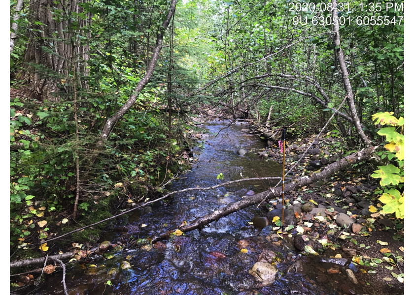
Figure 5.80: Habitat upstream of PSCIS crossing 124501.
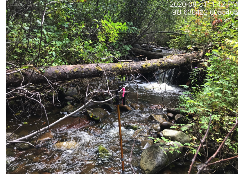
Figure 5.81: Habitat upstream of PSCIS crossing 124501.