4 Results and Discussion
Results of Morice Planning, Phase 1 and Phase 2 assessments are summarized in Figure 4.1 with additional details provided in sections below.
Figure 4.1: Map of fish passage and habitat confirmation results
4.1 Planning
Following review of background literature, fisheries information, PSCIS and bcfishpass outputs, 70 modelled and PSCIS crossings were reviewed to select sites for follow up with Phase 1 and 2 assessments in the Morice River watershed. 14 crossings ranked as high priority for future follow up with Phase 1 and/or Phase 2 assessments, 26 crossings ranked as moderate priorities, and 30 crossings ranked as low priorities. Georeferenced field maps are presented in here and available for bulk download as Attachment 1. Results of the planning review are presented in Figure 4.1 and included as a zipped Google Earth kml file for overlay on field maps as (Attachment 2). Although planning for field assessments ws still underway at the time of reporting through ongoing modelling, engagement with the Office of Wet’suwet’en, DFO, FLNRORD, BC Ministry of Environment, the Morice Watershed Monitoring Trust and numerous others, some key areas likely targeted for fieldwork include the Owen Creek, Lamprey Creek, McBride Lake, Nanika Lake, and Morice Lake watersheds.
4.2 Fish Passage Assessments
Field assessments were conducted between August 26 2020 and September 05 2020 by Allan Irvine, R.P.Bio. and Kyle Prince, P.Biol. A total of 30 Phase 1 assessments were conducted with 12 crossings considered “passable”, 3 crossings considered “potential” barriers and 11 crossings considered “barriers” according to threshold values based on culvert embedment, outlet drop, slope, diameter (relative to channel size) and length (MoE 2011). Georeferenced field maps are presented in here and available for bulk download as Attachment 1. A summary of crossings assessed, a cost benefit analysis and priority ranking for follow up for Phase 1 sites presented in Table 4.1. Detailed data with photos are presented in Appendix - Phase 1 Fish Passage Assessment Data and Photos.
“Barrier” and “Potential Barrier” rankings used in this project followed MoE (2011) and reflect an assessment of passability for juvenile salmon or small resident rainbow trout at any flows potentially present throughout the year (Clarkin et al. 2005 ; Bell 1991; Thompson 2013). As noted in Bourne et al. (2011), with a detailed review of different criteria in Kemp and O’Hanley (2010), passability of barriers can be quantified in many different ways. Fish physiology (i.e. species, length, swim speeds) can make defining passability complex but with important implications for evaluating connectivity and prioritizing remediation candidates (Bourne et al. 2011; Shaw et al. 2016; Mahlum et al. 2014; Kemp and O’Hanley 2010). Washington Department of Fish & Wildlife (2009) present criteria for assigning passability scores to culverts that have already been assessed as barriers in coarser level assessments. These passability scores provide additional information to feed into decision making processes related to the prioritization of remediation site candidates and have potential for application in British Columbia.
| PSCIS ID | Stream | Road | Result | Habitat value | Stream Width (m) | Priority | Fix | Cost Est ( $K) | Habitat Upstream (km) | Cost Benefit (m / $K) | Cost Benefit (m2 / $K) |
|---|---|---|---|---|---|---|---|---|---|---|---|
| 3067 | Byman Creek | North Road | Barrier | High | 9.0 | high | OBS | 390 | 3.99 | 10.2 | 46.0 |
| 58158 | McDowell Creek | Highway 16 | Barrier | High | 2.5 | high | OBS | 9750 | 9.90 | 1.0 | 1.3 |
| 123463 | Victor Creek | Tyee Lake Road | Barrier | Medium | 1.8 | mod | SS-CBS | 400 | 1.80 | 4.5 | 4.0 |
| 124502 | Tributary to Bulkley River | Lawson Road | Barrier | Medium | 3.2 | mod | OBS | 1000 | 8.68 | 8.7 | 13.9 |
| 197640 | Tributary to Buck Creek | Buck Flats FSR | Barrier | High | 5.1 | high | OBS | 1000 | 19.96 | 20.0 | 50.9 |
| 197646 | Tributary to Buck Creek | Spur off Parrot FSR | Barrier | Medium | 1.4 | mod | SS-CBS | 100 | 5.11 | 51.1 | 35.8 |
| 197647 | Tributary to Buck Creek | Carrier FSR | Barrier | Low | 1.5 | low | SS-CBS | 100 | 1.78 | 17.8 | 13.3 |
| 197653 | Perow Creek | Perow Loop Rd | Barrier | Medium | 2.5 | mod | OBS | 2000 | 34.23 | 17.1 | 21.4 |
| 197654 | Tributary to Buck Creek | Balsam FSR | Barrier | Medium | 1.5 | mod | SS-CBS | 100 | 3.34 | 33.4 | 25.0 |
| 197655 | McInnes Creek | Highway 16 | Potential | Low | 1.0 | low | SS-CBS | 1500 | 15.15 | 10.1 | 5.0 |
| 197656 | Tributary to Bulkley River | Highway 16 | Potential | Low | 5.0 | low | OBS | 7500 | 7.16 | 1.0 | 2.4 |
| 197657 | Perow Creek | Highway 16 | Potential | High | 3.2 | mod | OBS | 7500 | 0.19 | 0.0 | 0.0 |
| 197658 | Byman Creek | Highway 16 | Barrier | High | 11.1 | high | OBS | 11325 | 178.46 | 15.8 | 87.5 |
| 197662 | Richfield Creek | Highway 16 | Barrier | High | 12.5 | high | OBS | 12375 | 289.39 | 23.4 | 146.2 |
| 197663 | Johnny David Creek | Highway 16 | Barrier | High | 6.3 | high | OBS | 7725 | 85.39 | 11.1 | 34.8 |
| 197667 | Moan Creek | CN Railway | Barrier | High | 3.8 | high | OBS | 7500 | 9.68 | 1.3 | 2.5 |
| 197668 | Coffin Creek | CN Railway | Barrier | High | 5.3 | high | OBS | 7500 | 38.12 | 5.1 | 13.5 |
| 197669 | Riddeck Creek | Private | Barrier | High | 2.6 | high | OBS | 300 | 0.34 | 1.1 | 1.5 |
4.3 Habitat Confirmation Assessments
Although not assessed in 2020, Wilson and Rabnett (2007) report that the crossing structure located on Highway 16 and Station Creek (PSCIS 124420, UTM: 9U.586630.6122416) has been the subject of numerous assessments and designs with respect to the rehabilitation of fish passage, and they rated this crossing as the highest priority for rehabilitation in the Bulkley River watershed. Gitxsan Watershed Authority reports that Xsan Xsagiibil was a fishing site located at the mouth of Station Creek (Xsi Gwin Sagiiblax) (Wilson and Rabnett 2007). Identified as a high priority for additional assessments by Rabnett and Williams (2004), SKR Consultants Ltd. (2006) conducted a detailed inspection, offered rehabilitation design options and identified the natural limits of potential fish distribution to support rehabilitation efforts. At the time of this report, fish passage at the crossing had not yet been remediated due to complexities and costs associated with rehabilitation designs (Kathryn Graham, Regional Manager Environmental Services - Ministry of Transportation and Infrastructure pers. comm.).
During 2020 field assessments, habitat confirmation assessments were conducted at 22 sites in the Bulkley River watershed group and one site in the Morice River watershed group. A total of approximately 18 km of stream was assessed, fish sampling utilizing electrofishing and/or minnowtrapping was conducted at eight sites, and three sites were mapped using remotely piloted aircraft. Of note, in 2020, surveys in some larger mid Bulkley River tributaries with high potential low gradient habitat gains (ex. Toboggan Creek and John Brown Creek) were not conducted due to poor survey conditions caused by high water. Additionally, assessment at crossings on some large tributary streams in the upper Bulkley River were not conducted due to finite quantities of field time (ex. Ailport Creek, Cesford Creek and Watson Creek). Georeferenced field maps are presented in here and available for bulk download as Attachment 1.
As collaborative decision making was ongoing at the time of reporting, site prioritization can be considered preliminary. In total, Twelve crossings were rated as high priorities for proceeding to design for replacement, 9 crossings were rated as moderate priorities, and 2 crossings were rated as low priorities. Results are summarized in Figure 4.1 and Tables 4.2 - 4.2 with raw habitat and fish sampling data included in digital format as Attachment 4. A summary of preliminary modelling results illustrating the quantity of chinook, coho and steelhead spawning and rearing habitat potentially available upstream of each crossing as estimated by measured/modelled channel width and upstream accessible stream length are presented in Figure 4.3. Detailed information for each site assessed with Phase 2 assessments (including maps) are presented within site specific appendices to this document.
| PSCIS ID | Stream | Road | UTM (9U) | Fish Species | Habitat Gain (km) | Habitat Value | Priority | Comments |
|---|---|---|---|---|---|---|---|---|
| 3042 | Barren Creek | Barren Creek FSR | 654451 6042827 | RB | 1.7 | Medium | moderate | Wilson Falls is located downstream of the crossing, so restoration benefits resident rainbow trout. Beaver influenced habitat upstream. |
| 3054 | Johnny David Creek | North road | 664881 6052688 | RB | 7.5 | Medium | moderate | Smaller channel upstream with beaver activity throughout areas surveyed. Some potential for a natural barrier downstream. |
| 3139 | Trib to McQuarrie Creek | North Road | 656657 6048544 | RB | 7.3 | Medium | moderate | 4-5 m impassable falls downstream in McQuarrie Creek so remediation benefits resident rainbow trout. |
| 58159 | McDowell Creek | Woodmere Nursery Road | 627643 6060449 | RB, CO | 0.8 | Medium | high | Electrofishing conducted. Abundant cover available primarily as overhanging vegetation and cobbles. Upstream culvert under Highway 16 has been recently replaced by horizontal drilling. Baffles at upstream crossing. |
| 123445 | Tyhee Creek | Highway 16 | 627238 6061456 | BB,C,CAS,CC,CH,CM,CO,CT,GPW,LSU,MW,NSC,PCC,PK,PW,RB,RDC,RSC,SA,SK,ST,SU | 6.0 | Medium | high | Large outlet drop. Tyhee Lake upstream. Beaver dams and agricultural impacts between the highway and the lake. |
| 123446 | Tyhee Creek | Tyee Lake Road | 627527 6061771 | BB,C,CAS,CC,CH,CM,CO,CT,GPW,LSU,MW,NSC,PCC,PK,PW,RB,RDC,RSC,SA,SK,ST,SU | 5.5 | Medium | moderate | Beaver influenced wetland type habitat and private land between road and Tyhee Lake. |
| 123794 | Tributary to Blunt Creek | Blunt Creek FSR | 616100 6106763 | (RB) | 0.5 | Medium | moderate | Channel was noted as having good complexity with abundant gravels suitably sized for both coho and resident salmonid spawning. 4m high falls at top end of the site. |
| 123795 | Tributary to Blunt Creek | Blunt Creek FSR | 615760 6106892 | SA | 1.3 | Medium | moderate | Deep glide habitat. Very occasional pockets of gravel suitable for resident and adfluvial salmonid spawning. |
| 124487 | Porphyryr Creek | Highway 16 | 603073 6113363 | RB, DV | 8.0 | High | high | Boulders dominant form of cover with small woody debris, large woody debris, and overhanging vegetation also present. Some pockets of gravel suitable for spawning for resident and anadromous species with minimal pool habitat observed. Difficult survey conditions due to high water. |
| 124500 | Helps Creek | Lawson Road | 627552 6058697 | CT,DV,LNC,LSU,RB, ST, CO, L, SU | 9.0 | Medium | moderate | Multiple braided channels and ponds within beaver influenced wetland areas. Revisited in 2023 for electrofishing and CO captured upstream and downstream. |
| 124501 | Moan Creek | Lawson Road | 630661 6055713 | CO, CH, RB, CT, DV, BT | 2.8 | High | low | Embedded, baffled and without a significant outlet drop. Recent work completed by LGL and Wet’suwet’en First Nation. |
| 124504 | Coffin Creek | Lawson Road | 634323 6054587 | CO, CSU,CT,DV,LSU,MW,RB,RSC | 4.0 | High | moderate | Focus area for Environmental Stewardship Initiative. Embedded but non-backwatered. Downstream crossing is more of a pressing issue. |
| 195288 | Gibson Creek | Schnider Road | 640899 6051559 | RB, CT | 4.5 | Medium | high | Beaver influenced wetland complexes uspstream. Aerial survey conducted. |
| 195290 | Gibson Creek | Highway 16 | 640014 6051697 | RB, CT, CO, BT | 1.0 | Medium | high | Primarily beaver influenced wetland area upstream with narrow and deep channel. Electrofishing and aerial surveys conducted. Coho captured downstream but not upstream. |
| 197360 | Riddeck Creek | Morice-Owen FSR | 649936 5992406 | RB, LSU | 1.2 | High | high | Cover available in all forms with pools suitable for juvenile RB and CO overwintering. Abundant gravels and small cobbles throughout suitable for CO or RB/ST spawning. Electrofishing and aerial surveys conducted. Site part of the Bii Wenii Kwa Restoration/Recovery Plan, revisited in 2023 for electrofishing. |
| 197640 | Tributary to Buck Creek | Buck Flats Road | 654312 6012383 | RB | 4.2 | High | high | Rare pockets of gravel suitable for spawning resident, fluvial and anadromous salmonids. Stream aggraded with side bars common. An estimated 129ha of wetland upstream. |
| 197658 | Byman Creek | Highway 16 | 666847 6044305 | CO,CSU,LNC,LSU,RB,RSC,ST | 6.0 | High | high | High habitat complexity including numerous pools up to 2m deep and frequent glide sections to 1m deep. Extensive areas of gravel suitable for spawning for resident and anadromous species. Shallow depth of water during low flows could block salmon spawners. |
| 197662 | Richfield Creek | Highway 16 | 672405 6044146 | CH,CO,LNC,LSU,RB,ST | 2.0 | High | high | High habitat complexity including pools to 2m deep and glides to 1m deep. Water temperatures significantly cooler than in the upper Bulkley mainstem. |
| 197663 | Johnny David Creek | Highway 16 | 670241 6044772 | CO, RB, MW | 10.0 | High | high | Riffles installed to backwater outlet in 2017. Inlet of culvert damaged. Electrofishing conducted upstream and downstream with coho and rainbow captured. |
| 197664 | Barren Creek | Highway 16 | 660454 6037919 | CH,CO,CT,L,RB,SST,ST | 6.2 | High | moderate | Technically passable but undersized and part of infrastructure causing negative impacts on stream function. Dredging required to keep crossing from directing flows over Highway 16 during high flow events. |
| 197665 | Barren Creek | CN Railway | 660627 6037843 | CH,CO,CT,L,RB,SST,ST | 6.4 | High | low | Technically passable but undersized. Railway blocks access to a series of historic upper Bulkley River oxbows adjacent to the culvert location. Culvert appears to be potentially failing. |
| 197667 | Moan Creek | CN Railway | 631092 6055866 | CO, CH, RB, CT, DV, BT | 3.3 | High | high | Pockets of gravels and small cobbles suitable for resident and anadromous salmonid spawning. Undercut banks dominant with small woody debris, large woody debris, and overhanging vegetation also present. Perched culvert with shallow flows within pipe. |
| 197668 | Coffin Creek | CN Railway | 634336 6054609 | CO, CSU,CT,DV,LSU,MW,RB,RSC | 4.0 | High | high | Focus area for Environmental Stewardship Initiative. Backwater works completed in 2017 but do not appear to be effective. High habitat complexity with occasional patches of gravels suitable for spawning present. |
| PSCIS ID | Embedded | Outlet Drop (m) | Diameter (m) | SWR | Slope (%) | Length (m) | Final score | Barrier Result |
|---|---|---|---|---|---|---|---|---|
| 3042 | No | 0.00 | 1.00 | 1.0 | 1.5 | 23 | 21 | Barrier |
| 3054 | No | 0.76 | 3.00 | 1.2 | 2.0 | 40 | 34 | Barrier |
| 3139 | No | 1.02 | 1.20 | 3.2 | 2.0 | 27 | 34 | Barrier |
| 58159 | No | 0.36 | 1.00 | 2.3 | 3.0 | 14 | 36 | Barrier |
| 123445 | No | 0.90 | 0.90 | 3.1 | 3.0 | 50 | 42 | Barrier |
| 123446 | No | 0.00 | 1.85 | 1.4 | 1.1 | 21 | 24 | Barrier |
| 123794 | No | 0.25 | 0.90 | 1.9 | 5.0 | 13 | 31 | Barrier |
| 123795 | No | 0.17 | 0.90 | 1.6 | 1.0 | 15 | 29 | Barrier |
| 124487 | No | 2.50 | 5.00 | 2.2 | 4.0 | 99 | 42 | Barrier |
| 124500 | No | 0.00 | 1.50 | 2.4 | 1.0 | 14 | 21 | Barrier |
| 124501 | Yes | 0.30 | 1.60 | 2.8 | 6.0 | 25 | 34 | Barrier |
| 124504 | Yes | 0.20 | 3.00 | 1.8 | 1.0 | 16 | 24 | Barrier |
| 195288 | No | 0.30 | 1.20 | 2.5 | 1.0 | 11 | 31 | Barrier |
| 195290 | No | 0.66 | 0.80 | 3.0 | 1.5 | 0 | 31 | Barrier |
| 197360 | No | 0.24 | 1.20 | 1.8 | 1.0 | 27 | 29 | Barrier |
| 197640 | No | 0.40 | 1.50 | 3.4 | 1.5 | 12 | 31 | Barrier |
| 197658 | No | 2.00 | 4.00 | 2.8 | 4.0 | 24 | 39 | Barrier |
| 197662 | No | 0.20 | 4.20 | 3.0 | 2.0 | 24 | 29 | Barrier |
| 197663 | No | 0.00 | 1.75 | 3.6 | 2.0 | 25 | 24 | Barrier |
| 197664 | Yes | 0.00 | 2.50 | 1.9 | 2.0 | 15 | 14 | Passable |
| 197665 | Yes | 0.00 | 0.90 | 3.9 | 1.0 | 25 | 14 | Passable |
| 197667 | No | 0.58 | 2.50 | 1.5 | 4.0 | 17 | 39 | Barrier |
| 197668 | No | 0.27 | 3.00 | 1.8 | 2.0 | 15 | 29 | Barrier |
| PSCIS ID | Stream | Road | Result | Habitat value | Stream Width (m) | Fix | Cost Est (in $K) | Habitat Upstream (m) | Cost Benefit (m / $K) | Cost Benefit (m2 / $K) |
|---|---|---|---|---|---|---|---|---|---|---|
| 3042 | Barren Creek | Barren Creek FSR | Barrier | Medium | 2.4 | SS-CBS | 100 | 1700 | 17.0 | 40.8 |
| 3054 | Johnny David Creek | North road | Barrier | Medium | 2.6 | OBS | 930 | 7500 | 8.1 | 21.0 |
| 3139 | Trib to McQuarrie Creek | North Road | Barrier | Medium | 3.3 | OBS | 390 | 7300 | 18.7 | 61.8 |
| 58159 | McDowell Creek | Woodmere Nursery Road | Barrier | Medium | 2.2 | OBS | 300 | 780 | 2.6 | 5.7 |
| 123445 | Tyee Creek | Highway 16 | Barrier | Medium | 2.1 | OBS | 18750 | 6000 | 0.3 | 0.7 |
| 123446 | Tyee Creek | Tyee Lake Road | Barrier | Medium | 8.5 | OBS | 2000 | 5500 | 2.8 | 23.4 |
| 123794 | Tributary to Blunt Creek | Blunt Creek FSR | Barrier | Medium | 1.9 | SS-CBS | 100 | 525 | 5.2 | 10.0 |
| 123795 | Tributary to Blunt Creek | Blunt Creek FSR | Barrier | Medium | 1.4 | OBS | 150 | 1300 | 8.7 | 12.1 |
| 124487 | Porphyryr Creek | Highway 16 | Barrier | High | 10.7 | OBS | 23250 | 8000 | 0.3 | 3.7 |
| 124500 | Helps Creek | Lawson Road | Barrier | Medium | 4.8 | OBS | 1000 | 9000 | 9.0 | 43.2 |
| 124501 | Moan Creek | Lawson Road | Barrier | High | 4.8 | OBS | 1000 | 2800 | 2.8 | 13.4 |
| 124504 | Coffin Creek | Lawson Road | Barrier | High | 5.8 | OBS | 1000 | 4000 | 4.0 | 23.2 |
| 195288 | Gibson Creek | Schnider Road | Barrier | Medium | 2.0 | OBS | 2000 | 4500 | 2.2 | 4.5 |
| 195290 | Gibson Creek | Highway 16 | Barrier | Medium | 2.0 | OBS | 14250 | 1000 | 0.1 | 0.1 |
| 197360 | Riddeck Creek | Morice-Owen FSR | Barrier | High | 3.3 | OBS | 300 | 1200 | 4.0 | 13.2 |
| 197640 | Tributary to Buck Creek | Buck Flats Road | Barrier | High | 4.4 | OBS | 1000 | 4200 | 4.2 | 18.5 |
| 197658 | Byman Creek | Highway 16 | Barrier | High | 12.9 | OBS | 11325 | 6000 | 0.5 | 6.8 |
| 197662 | Richfield Creek | Highway 16 | Barrier | High | 13.2 | OBS | 12375 | 2000 | 0.2 | 2.1 |
| 197663 | Johnny David Creek | Highway 16 | Barrier | High | 6.6 | OBS | 7725 | 10000 | 1.3 | 8.5 |
| 197664 | Barren Creek | Highway 16 | Passable | High | 7.2 | – | – | 6200 | – | – |
| 197665 | Barren Creek | CN Railway | Passable | High | – | – | – | 6400 | – | – |
| 197667 | Moan Creek | CN Railway | Barrier | High | 4.5 | OBS | 7500 | 3300 | 0.4 | 2.0 |
| 197668 | Coffin Creek | CN Railway | Barrier | High | 5.3 | OBS | 7500 | 4000 | 0.5 | 2.8 |
| PSCIS ID | Length surveyed upstream (m) | Channel Width (m) | Wetted Width (m) | Pool Depth (m) | Gradient (%) | Total Cover | Habitat Value |
|---|---|---|---|---|---|---|---|
| 3042 | 400 | 2.4 | 2.2 | 0.2 | 3 | moderate | moderate |
| 3054 | 725 | 2.6 | 2.1 | 0.3 | 5.3 | moderate | moderate |
| 3139 | 625 | 3.3 | 2.7 | 0.4 | 7.2 | abundant | high |
| 58159 | 440 | 2.2 | 1.8 | 0.4 | 2 | abundant | moderate |
| 123445 | 540 | 2.1 | 1.6 | – | 0.5 | moderate | moderate |
| 123446 | 100 | 8.5 | 7.5 | 0.8 | 0.2 | abundant | moderate |
| 123794 | 525 | 1.9 | 1.6 | 0.2 | 9.6 | moderate | moderate |
| 123795 | 650 | 1.4 | 1.3 | 0.3 | 7.2 | abundant | moderate |
| 124487 | 540 | 10.7 | 9.9 | 0.3 | 4.8 | moderate | moderate |
| 124500 | 1100 | 4.8 | 4.1 | – | 0.7 | moderate | moderate |
| 124501 | 520 | 4.8 | 3.1 | 0.4 | 6.3 | moderate | high |
| 124504 | 415 | 5.8 | 3.5 | 0.4 | 2.3 | moderate | high |
| 195288 | 180 | 2 | 2 | – | 0 | – | moderate |
| 195290 | 150 | 2 | 1.6 | 0.6 | 1.3 | abundant | moderate |
| 197360 | 1200 | 3.3 | 1.8 | 0.4 | 2.7 | moderate | high |
| 197640 | 535 | 4.4 | 2.2 | 0.3 | 2.5 | moderate | moderate |
| 197658 | 1400 | 12.9 | 7.9 | 0.6 | 2.1 | moderate | high |
| 197662 | 1200 | 13.2 | 9 | 0.8 | 2.1 | moderate | high |
| 197663 | 690 | 6.6 | 4.4 | 0.4 | 3 | moderate | high |
| 197664 | 800 | 7.2 | 4.7 | 3 | 3 | moderate | high |
| 197665 | 100 | – | – | – | – | – | moderate |
| 197667 | 100 | 4.5 | – | – | – | – | high |
| 197668 | 40 | 5.3 | – | – | – | – | high |
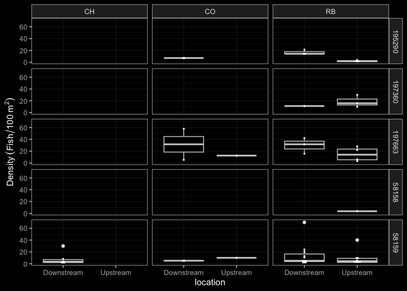
Figure 4.2: Boxplots of densities (fish/100m2) of fish captured by life stage and site for data collected during habitat confirmation assessments.
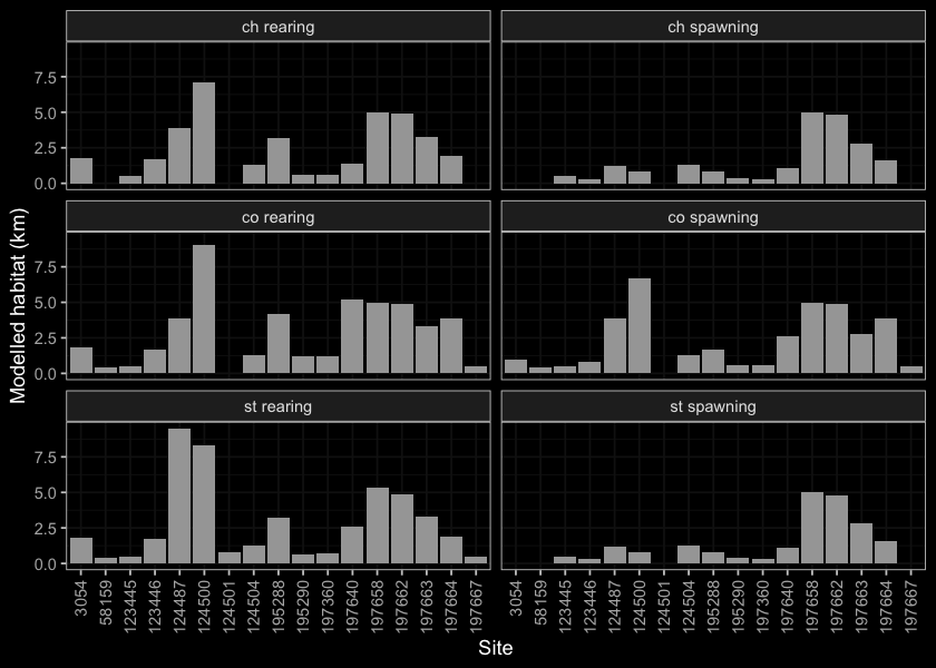
Figure 4.3: Summary of potential habitat upstream of habitat confirmation assessment sites estimated based on modelled channel width and upstream channel length.