STAC ortho timelapse
Source:vignettes/stac-sentinel2-ortho-timelapse.Rmd
stac-sentinel2-ortho-timelapse.RmdPlanetary Computer Collections
The Microsoft
Planetary Computer hosts a STAC catalog with numerous Earth
observation datasets. We can use rstac to query the
available collections directly from the API:
stac_url <- "https://planetarycomputer.microsoft.com/api/stac/v1"

# Fetch all collections from the Planetary Computer STAC catalog
collections <- rstac::stac(stac_url) |>
  rstac::collections() |>
  rstac::get_request()

# determin which dtasets overlap bc
# bc_bbox <- c(-139, 48, -114, 60)

 #100km buffer from the us border to not overlap all the us dtasets
bc_bbox <- c(-139, 49.5, -114, 60)

bc_overlap <-  purrr::keep(collections$collections, ~ {

  bbox <- .x$extent$spatial$bbox[[1]]
  bbox[1] <= bc_bbox[3] && bbox[3] >= bc_bbox[1] &&
   bbox[2] <= bc_bbox[4] && bbox[4] >= bc_bbox[2]
  }) |>
  purrr::map_chr("id")

# Extract collection IDs and descriptions into a data frame
collections_df <- purrr::map_df(collections$collections, ~ {
    interval <- .x$extent$temporal$interval[[1]]
    data.frame(
      id = .x$id,
      start = interval[[1]],
      end = interval[[2]],
      description = paste0(.x$title, ": ", paste(.x$keywords %||% NA_character_, collapse = ", ")),
      check.names = FALSE
    )
  }) |>
    dplyr::mutate(
      start = as.Date(start),
      end = as.Date(end),
      # rowid = dplyr::row_number(),
      bc_overlap = dplyr::if_else(id %in% bc_overlap, "yes", "no"), .after = id
    ) |>
  dplyr::arrange(id)


collections_df |>
  kableExtra::kbl() |>
  kableExtra::scroll_box(width = "100%", height = "500px") |>
  kableExtra::kable_styling(c("condensed",
"responsive"), full_width = T, font_size = 10)| id | bc_overlap | start | end | description |
|---|---|---|---|---|
| 3dep-lidar-classification | yes | 2012-01-01 | 2022-01-01 | USGS 3DEP Lidar Classification: USGS, 3DEP, COG, Classification |
| 3dep-lidar-copc | yes | 2012-01-01 | 2022-01-01 | USGS 3DEP Lidar Point Cloud: USGS, 3DEP, COG, Point cloud |
| 3dep-lidar-dsm | yes | 2012-01-01 | 2022-01-01 | USGS 3DEP Lidar Digital Surface Model: USGS, 3DEP, COG, DSM |
| 3dep-lidar-dtm | yes | 2012-01-01 | 2022-01-01 | USGS 3DEP Lidar Digital Terrain Model: USGS, 3DEP, COG, DTM |
| 3dep-lidar-dtm-native | yes | 2012-01-01 | 2022-01-01 | USGS 3DEP Lidar Digital Terrain Model (Native): USGS, 3DEP, COG, DTM |
| 3dep-lidar-hag | yes | 2012-01-01 | 2022-01-01 | USGS 3DEP Lidar Height above Ground: USGS, 3DEP, COG, Elevation |
| 3dep-lidar-intensity | yes | 2012-01-01 | 2022-01-01 | USGS 3DEP Lidar Intensity: USGS, 3DEP, COG, Intensity |
| 3dep-lidar-pointsourceid | yes | 2012-01-01 | 2022-01-01 | USGS 3DEP Lidar Point Source: USGS, 3DEP, COG, PointSourceId |
| 3dep-lidar-returns | yes | 2012-01-01 | 2022-01-01 | USGS 3DEP Lidar Returns: USGS, 3DEP, COG, NumberOfReturns |
| 3dep-seamless | yes | 1925-01-01 | 2020-05-06 | USGS 3DEP Seamless DEMs: USGS, 3DEP, NED, Elevation, DEM |
| alos-dem | yes | 2016-12-07 | 2016-12-07 | ALOS World 3D-30m: ALOS, PRISM, JAXA, DEM, DSM, Elevation |
| alos-fnf-mosaic | no | 2015-01-01 | 2020-12-31 | ALOS Forest/Non-Forest Annual Mosaic: ALOS, JAXA, Forest, Land Cover, Global |
| alos-palsar-mosaic | no | 2015-01-01 | 2021-12-31 | ALOS PALSAR Annual Mosaic: ALOS, JAXA, Remote Sensing, Global |
| aster-l1t | yes | 2000-03-04 | 2006-12-31 | ASTER L1T: ASTER, USGS, NASA, Satellite, Global |
| chesapeake-lc-13 | no | 2013-01-01 | 2014-12-31 | Chesapeake Land Cover (13-class): Land Cover, Chesapeake Bay Watershed, Chesapeake Conservancy |
| chesapeake-lc-7 | no | 2013-01-01 | 2014-12-31 | Chesapeake Land Cover (7-class): Land Cover, Chesapeake Bay Watershed, Chesapeake Conservancy |
| chesapeake-lu | no | 2013-01-01 | 2014-12-31 | Chesapeake Land Use: Land Use, Chesapeake Bay Watershed, Chesapeake Conservancy |
| chloris-biomass | yes | 2003-07-31 | 2019-07-31 | Chloris Biomass: Chloris, Biomass, MODIS, Carbon |
| cil-gdpcir-cc-by | yes | 1950-01-01 | 2100-12-31 | CIL Global Downscaled Projections for Climate Impacts Research (CC-BY-4.0): CMIP6, Climate Impact Lab, Rhodium Group, Precipitation, Temperature |
| cil-gdpcir-cc-by-sa | yes | 1950-01-01 | 2100-12-31 | CIL Global Downscaled Projections for Climate Impacts Research (CC-BY-SA-4.0): CMIP6, Climate Impact Lab, Rhodium Group, Precipitation, Temperature |
| cil-gdpcir-cc0 | yes | 1950-01-01 | 2100-12-31 | CIL Global Downscaled Projections for Climate Impacts Research (CC0-1.0): CMIP6, Climate Impact Lab, Rhodium Group, Precipitation, Temperature |
| conus404 | yes | 1979-10-01 | 2022-09-30 | CONUS404: CONUS404, Hydroclimate, Hydrology, Inland Waters, Precipitation, Weather, Climate |
| cop-dem-glo-30 | yes | 2021-04-22 | 2021-04-22 | Copernicus DEM GLO-30: Copernicus, DEM, DSM, Elevation |
| cop-dem-glo-90 | yes | 2021-04-22 | 2021-04-22 | Copernicus DEM GLO-90: Copernicus, DEM, Elevation |
| daymet-annual-hi | no | 1980-07-01 | 2020-07-01 | Daymet Annual Hawaii: Daymet, Hawaii, Temperature, Precipitation, Vapor Pressure, Climate |
| daymet-annual-na | yes | 1980-07-01 | 2020-07-01 | Daymet Annual North America: Daymet, North America, Temperature, Precipitation, Vapor Pressure, Climate |
| daymet-annual-pr | no | 1980-07-01 | 2020-07-01 | Daymet Annual Puerto Rico: Daymet, Puerto Rico, Temperature, Precipitation, Vapor Pressure, Climate |
| daymet-daily-hi | no | 1980-01-01 | 2020-12-30 | Daymet Daily Hawaii: Daymet, Hawaii, Temperature, Precipitation, Vapor Pressure, Weather |
| daymet-daily-na | yes | 1980-01-01 | 2020-12-30 | Daymet Daily North America: Daymet, North America, Temperature, Precipitation, Vapor Pressure, Weather |
| daymet-daily-pr | no | 1980-01-01 | 2020-12-30 | Daymet Daily Puerto Rico: Daymet, Puerto Rico, Temperature, Precipitation, Vapor Pressure, Weather |
| daymet-monthly-hi | no | 1980-01-16 | 2020-12-16 | Daymet Monthly Hawaii: Daymet, Hawaii, Temperature, Precipitation, Vapor Pressure, Climate |
| daymet-monthly-na | yes | 1980-01-16 | 2020-12-16 | Daymet Monthly North America: Daymet, North America, Temperature, Precipitation, Vapor Pressure, Climate |
| daymet-monthly-pr | no | 1980-01-16 | 2020-12-16 | Daymet Monthly Puerto Rico: Daymet, Puerto Rico, Temperature, Precipitation, Vapor Pressure, Climate |
| deltares-floods | no | 2018-01-01 | 2018-12-31 | Deltares Global Flood Maps: Deltares, Flood, Sea level rise, Water, Global |
| deltares-water-availability | no | 1970-01-01 | 2020-12-31 | Deltares Global Water Availability: Deltares, Water availability, Reservoir, Water, Precipitation |
| drcog-lulc | no | 2018-01-01 | 2020-12-31 | Denver Regional Council of Governments Land Use Land Cover: Land Cover, Land Use, NAIP, USDA |
| eclipse | no | 2021-01-01 | NA | Urban Innovation Eclipse Sensor Data: Eclipse, PM25, air pollution |
| ecmwf-forecast | no | NA | NA | ECMWF Open Data (real-time): ECMWF, forecast, weather |
| era5-pds | yes | 1979-01-01 | NA | ERA5 - PDS: ERA5, ECMWF, Precipitation, Temperature, Reanalysis, Weather |
| esa-cci-lc | yes | 1992-01-01 | 2020-12-31 | ESA Climate Change Initiative Land Cover Maps (Cloud Optimized GeoTIFF): Land Cover, ESA, CCI, Global |
| esa-cci-lc-netcdf | yes | 1992-01-01 | 2020-12-31 | ESA Climate Change Initiative Land Cover Maps (NetCDF): Land Cover, ESA, CCI, Global |
| esa-worldcover | yes | 2020-01-01 | 2021-12-31 | ESA WorldCover: Global, Land Cover, Sentinel, ESA |
| fia | no | 2020-06-01 | NA | Forest Inventory and Analysis: Forest, Species, Carbon, Biomass, USDA, Forest Service |
| fws-nwi | no | 2022-10-01 | 2022-10-01 | FWS National Wetlands Inventory: USFWS, Wetlands, United States |
| gap | yes | 1999-01-01 | 2011-12-31 | USGS Gap Land Cover: USGS, GAP, LANDFIRE, Land Cover, United States |
| gbif | yes | 2021-04-13 | NA | Global Biodiversity Information Facility (GBIF): GBIF, Biodiversity, Species |
| gnatsgo-rasters | no | 2020-07-01 | 2020-07-01 | gNATSGO Soil Database - Rasters: Soils, NATSGO, SSURGO, STATSGO2, RSS, USDA, United States |
| gnatsgo-tables | no | 2020-07-01 | 2020-07-01 | gNATSGO Soil Database - Tables: Soils, NATSGO, SSURGO, STATSGO2, RSS, USDA, United States |
| goes-cmi | yes | 2017-02-28 | NA | GOES-R Cloud & Moisture Imagery: GOES, NOAA, NASA, Satellite, Cloud, Moisture |
| goes-glm | yes | 2018-02-13 | NA | GOES-R Lightning Detection: GOES, NOAA, NASA, Satellite, Lightning, Weather |
| gpm-imerg-hhr | yes | 2000-06-01 | 2021-05-31 | GPM IMERG: IMERG, GPM, Precipitation |
| gridmet | no | 1979-01-01 | 2020-12-31 | gridMET: gridMET, Water, Precipitation, Temperature, Vapor Pressure, Climate |
| hgb | yes | 2010-12-31 | 2010-12-31 | HGB: Harmonized Global Biomass for 2010: Biomass, Carbon, ORNL |
| hls2-l30 | yes | 2020-01-01 | NA | Harmonized Landsat Sentinel-2 (HLS) Version 2.0, Landsat Data: Sentinel, Landsat, HLS, Satellite, Global, Imagery |
| hls2-s30 | yes | 2020-01-01 | NA | Harmonized Landsat Sentinel-2 (HLS) Version 2.0, Sentinel-2 Data: Sentinel, Landsat, HLS, Satellite, Global, Imagery |
| hrea | no | 2012-12-31 | 2019-12-31 | HREA: High Resolution Electricity Access: HREA, Electricity, VIIRS |
| io-biodiversity | yes | 2017-01-01 | 2020-12-31 | Biodiversity Intactness: Global, Biodiversity |
| io-lulc | yes | 2017-01-01 | 2021-01-01 | Esri 10-Meter Land Cover (10-class): Global, Land Cover, Land Use, Sentinel |
| io-lulc-9-class | yes | 2017-01-01 | 2023-01-01 | 10m Annual Land Use Land Cover (9-class) V1: Global, Land Cover, Land Use, Sentinel |
| io-lulc-annual-v02 | yes | 2017-01-01 | 2024-01-01 | 10m Annual Land Use Land Cover (9-class) V2: Global, Land Cover, Land Use, Sentinel |
| jrc-gsw | yes | 1984-03-01 | 2020-12-31 | JRC Global Surface Water: Global, Water, Landsat |
| kaza-hydroforecast | no | 2022-01-01 | NA | HydroForecast - Kwando & Upper Zambezi Rivers: Water, HydroForecast, Streamflow, Hydrology, Upstream Tech |
| landsat-8-c2-l2 | yes | 2013-04-11 | NA | Landsat 8 Collection 2 Level-2: Landsat, USGS, NASA, Satellite, Global, Imagery, Reflectance |
| landsat-c2-l1 | yes | 1972-07-25 | 2013-01-07 | Landsat Collection 2 Level-1: Landsat, USGS, NASA, Satellite, Global, Imagery |
| landsat-c2-l2 | yes | 1982-08-22 | NA | Landsat Collection 2 Level-2: Landsat, USGS, NASA, Satellite, Global, Imagery, Reflectance, Temperature |
| met-office-global-deterministic-height | yes | 2023-12-15 | NA | Height levels collection Met Office Global 10km deterministic weather forecast: Met Office, Weather, Forecast, Global, Cloud |
| met-office-global-deterministic-near-surface | yes | 2023-12-15 | NA | Near-surface level collection Met Office global deterministic 10km forecast: Met Office, Global, Forecast, Cloud, Fog, Heat Flux, Precipitation, Pressure, Radiation, Rainfall, Humidity, Snow, Temperature, Wind |
| met-office-global-deterministic-pressure | yes | 2023-12-15 | NA | Pressure levels collection Met Office Global 10km deterministic weather forecast: MetOffice, Global, Cloud |
| met-office-global-deterministic-whole-atmosphere | yes | 2023-12-15 | NA | Whole Atmosphere collection Met Office Global 10km deterministic weather forecast: MetOffice, Global, Cloud |
| met-office-uk-deterministic-height | no | 2023-12-15 | NA | Height levels collection Met Office UKV 2km deterministic forecast: Met Office, Weather, Forecast, UK, Cloud, Temperature, Wind, Height |
| met-office-uk-deterministic-near-surface | no | 2023-12-15 | NA | Near-surface level collection Met Office UKV 2km deterministic forecast: Met Office, Weather, Forecast, UK, Precipitation, Temperature, Wind, Pressure, Humidity |
| met-office-uk-deterministic-pressure | no | 2023-12-15 | NA | Pressure levels collection Met Office UKV 2km deterministic forecast: Met Office, Weather, Forecast, UK, Temperature, Wind, Pressure, Humidity |
| met-office-uk-deterministic-whole-atmosphere | no | 2023-12-15 | NA | Whole Atmosphere collection Met Office UKV 2km deterministic forecast: Met Office, Weather, Forecast, UK, CAPE, Cloud, Freezing, Wet Bulb, Lightning |
| mobi | no | 2020-04-14 | 2020-04-14 | MoBI: Map of Biodiversity Importance: MoBI, Natureserve, United States, Biodiversity |
| modis-09A1-061 | yes | 2000-02-18 | NA | MODIS Surface Reflectance 8-Day (500m): NASA, MODIS, Satellite, Imagery, Global, Reflectance, MOD09A1, MYD09A1 |
| modis-09Q1-061 | yes | 2000-02-18 | NA | MODIS Surface Reflectance 8-Day (250m): NASA, MODIS, Satellite, Imagery, Global, Reflectance, MOD09Q1, MYD09Q1 |
| modis-10A1-061 | yes | 2000-02-24 | NA | MODIS Snow Cover Daily: NASA, MODIS, Satellite, Global, Snow, MOD10A1, MYD10A1 |
| modis-10A2-061 | yes | 2000-02-18 | NA | MODIS Snow Cover 8-day: NASA, MODIS, Satellite, Global, Snow, MOD10A2, MYD10A2 |
| modis-11A1-061 | yes | 2000-02-24 | NA | MODIS Land Surface Temperature/Emissivity Daily: NASA, MODIS, Satellite, Global, Temperature, MOD11A1, MYD11A1 |
| modis-11A2-061 | yes | 2000-02-18 | NA | MODIS Land Surface Temperature/Emissivity 8-Day: NASA, MODIS, Satellite, Global, Temperature, MOD11A2, MYD11A2 |
| modis-13A1-061 | yes | 2000-02-18 | NA | MODIS Vegetation Indices 16-Day (500m): NASA, MODIS, Satellite, Global, Vegetation, MOD13A1, MYD13A1 |
| modis-13Q1-061 | yes | 2000-02-18 | NA | MODIS Vegetation Indices 16-Day (250m): NASA, MODIS, Satellite, Global, Vegetation, MOD13Q1, MYD13Q1 |
| modis-14A1-061 | yes | 2000-02-18 | NA | MODIS Thermal Anomalies/Fire Daily: NASA, MODIS, Satellite, Global, Fire, MOD14A1, MYD14A1 |
| modis-14A2-061 | yes | 2000-02-18 | NA | MODIS Thermal Anomalies/Fire 8-Day: NASA, MODIS, Satellite, Global, Fire, MOD14A2, MYD14A2 |
| modis-15A2H-061 | yes | 2002-07-04 | NA | MODIS Leaf Area Index/FPAR 8-Day: NASA, MODIS, Satellite, Global, Vegetation, MCD15A2H, MOD15A2H, MYD15A2H |
| modis-15A3H-061 | yes | 2002-07-04 | NA | MODIS Leaf Area Index/FPAR 4-Day: NASA, MODIS, Satellite, Global, Vegetation, MCD15A3H |
| modis-16A3GF-061 | yes | 2001-01-01 | NA | MODIS Net Evapotranspiration Yearly Gap-Filled: NASA, MODIS, Satellite, Global, Vegetation, MOD16A3GF, MYD16A3GF |
| modis-17A2H-061 | yes | 2000-02-18 | NA | MODIS Gross Primary Productivity 8-Day: NASA, MODIS, Satellite, Vegetation, Global, MOD17A2H, MYD17A2H |
| modis-17A2HGF-061 | yes | 2000-02-18 | NA | MODIS Gross Primary Productivity 8-Day Gap-Filled: NASA, MODIS, Satellite, Vegetation, Global, MOD17A2HGF, MYD17A2HGF |
| modis-17A3HGF-061 | yes | 2000-02-18 | NA | MODIS Net Primary Production Yearly Gap-Filled: NASA, MODIS, Satellite, Vegetation, Global, MOD17A3HGF, MYD17A3HGF |
| modis-21A2-061 | yes | 2000-02-16 | NA | MODIS Land Surface Temperature/3-Band Emissivity 8-Day: NASA, MODIS, Satellite, Global, Temperature, MOD21A2, MYD21A2 |
| modis-43A4-061 | yes | 2000-02-16 | NA | MODIS Nadir BRDF-Adjusted Reflectance (NBAR) Daily: NASA, MODIS, Satellite, Imagery, Global, Reflectance, MCD43A4 |
| modis-64A1-061 | yes | 2000-11-01 | NA | MODIS Burned Area Monthly: NASA, MODIS, Satellite, Imagery, Global, Fire, MCD64A1 |
| ms-buildings | no | 2014-01-01 | NA | Microsoft Building Footprints: Bing Maps, Buildings, geoparquet, Microsoft, Footprint, Delta |
| mtbs | yes | 1984-12-31 | 2018-12-31 | MTBS: Monitoring Trends in Burn Severity: MTBS, USGS, USFS, USDA, Forest, Fire |
| naip | no | 2010-01-01 | 2023-12-31 | NAIP: National Agriculture Imagery Program: NAIP, Aerial, Imagery, USDA, AFPO, Agriculture, United States |
| nasa-nex-gddp-cmip6 | yes | 1950-01-01 | 2100-12-31 | Earth Exchange Global Daily Downscaled Projections (NEX-GDDP-CMIP6): CMIP6, NASA, Climate, Humidity, Precipitation, Temperature |
| nasadem | yes | 2000-02-20 | 2000-02-20 | NASADEM HGT v001: NASA, JPL, Elevation, DEM, USGS, NGA, SRTM |
| noaa-c-cap | no | 1975-01-01 | 2016-12-31 | C-CAP Regional Land Cover and Change: Land Cover, Land Use, NOAA, Coastal |
| noaa-cdr-ocean-heat-content | yes | 1972-03-01 | 2022-03-31 | Global Ocean Heat Content CDR: Global, Climate, NOAA, Temperature, Ocean |
| noaa-cdr-ocean-heat-content-netcdf | yes | 1972-03-01 | 2022-03-31 | Global Ocean Heat Content CDR NetCDFs: Global, Climate, NOAA, Temperature, Ocean |
| noaa-cdr-sea-surface-temperature-optimum-interpolation | yes | 1981-09-01 | NA | Sea Surface Temperature - Optimum Interpolation CDR: Global, Climate, NOAA, Temperature, Ocean |
| noaa-cdr-sea-surface-temperature-whoi | yes | 1988-01-01 | NA | Sea Surface Temperature - WHOI CDR: Global, Climate, NOAA, Ocean, Temperature |
| noaa-cdr-sea-surface-temperature-whoi-netcdf | yes | 1988-01-01 | NA | Sea Surface Temperature - WHOI CDR NetCDFs: Global, Climate, NOAA, Ocean, Temperature |
| noaa-climate-normals-gridded | no | 1901-01-01 | 2020-12-31 | NOAA US Gridded Climate Normals (Cloud-Optimized GeoTIFF): NOAA, Climate Normals, Weather, Surface Observations, Climatology, CONUS |
| noaa-climate-normals-netcdf | no | 1901-01-01 | 2020-12-31 | NOAA US Gridded Climate Normals (NetCDF): NOAA, Climate Normals, Weather, Surface Observations, Climatology, CONUS |
| noaa-climate-normals-tabular | yes | 1981-01-01 | 2020-12-31 | NOAA US Tabular Climate Normals: NOAA, Climate Normals, Weather, Surface Observations, Climatology, CONUS |
| noaa-hrrr | yes | 2021-03-21 | NA | NOAA High Resolution Rapid Refresh (HRRR): NOAA, HRRR, forecast, atmospheric, weather |
| noaa-mrms-qpe-1h-pass1 | yes | 2022-07-21 | NA | NOAA MRMS QPE 1-Hour Pass 1: NOAA, MRMS, QPE, Precipitation, Weather, United States, Guam, Caribbean |
| noaa-mrms-qpe-1h-pass2 | yes | 2022-07-21 | NA | NOAA MRMS QPE 1-Hour Pass 2: NOAA, MRMS, QPE, Precipitation, Weather, United States, Guam, Caribbean |
| noaa-mrms-qpe-24h-pass2 | yes | 2022-07-21 | NA | NOAA MRMS QPE 24-Hour Pass 2: NOAA, MRMS, QPE, Precipitation, Weather, United States, Guam, Caribbean |
| noaa-nclimgrid-monthly | no | 1895-01-01 | NA | Monthly NOAA U.S. Climate Gridded Dataset (NClimGrid): United States, NOAA, NClimGrid, Climate, Precipitation, Temperature |
| nrcan-landcover | yes | 2015-01-01 | 2020-01-01 | Land Cover of Canada: Land Cover, Remote Sensing, Landsat, North America, Canada |
| planet-nicfi-analytic | no | 2015-12-01 | NA | Planet-NICFI Basemaps (Analytic): Planet, NICFI, Satellite, Tropics, Imagery |
| planet-nicfi-visual | no | 2015-12-01 | NA | Planet-NICFI Basemaps (Visual): Planet, NICFI, Satellite, Tropics, Imagery |
| sentinel-1-grd | yes | 2014-10-10 | NA | Sentinel 1 Level-1 Ground Range Detected (GRD): ESA, Copernicus, Sentinel, C-Band, SAR, GRD |
| sentinel-1-rtc | yes | 2014-10-10 | NA | Sentinel 1 Radiometrically Terrain Corrected (RTC): ESA, Copernicus, Sentinel, C-Band, SAR, RTC |
| sentinel-2-l2a | yes | 2015-06-27 | NA | Sentinel-2 Level-2A: Sentinel, Copernicus, ESA, Satellite, Global, Imagery, Reflectance |
| sentinel-3-olci-lfr-l2-netcdf | yes | 2016-04-25 | NA | Sentinel-3 Land (Full Resolution): ESA, Copernicus, Sentinel, Land, Biomass |
| sentinel-3-olci-wfr-l2-netcdf | yes | 2017-11-01 | NA | Sentinel-3 Water (Full Resolution): ESA, Copernicus, Sentinel, Water, Ocean |
| sentinel-3-slstr-frp-l2-netcdf | yes | 2020-08-08 | NA | Sentinel-3 Fire Radiative Power: Sentinel, Copernicus, ESA, Satellite, Temperature, Fire |
| sentinel-3-slstr-lst-l2-netcdf | yes | 2016-04-19 | NA | Sentinel-3 Land Surface Temperature: Sentinel, Copernicus, ESA, Satellite, Temperature, Land |
| sentinel-3-slstr-wst-l2-netcdf | yes | 2017-10-31 | NA | Sentinel-3 Sea Surface Temperature: Sentinel, Copernicus, ESA, Satellite, Temperature, Ocean |
| sentinel-3-sral-lan-l2-netcdf | yes | 2016-03-01 | NA | Sentinel-3 Land Radar Altimetry: Sentinel, Copernicus, ESA, Satellite, Radar, Altimetry |
| sentinel-3-sral-wat-l2-netcdf | yes | 2017-01-28 | NA | Sentinel-3 Ocean Radar Altimetry: Sentinel, Copernicus, ESA, Satellite, Radar, Altimetry, Ocean |
| sentinel-3-synergy-aod-l2-netcdf | yes | 2020-04-16 | NA | Sentinel-3 Global Aerosol: Sentinel, Copernicus, ESA, Satellite, Global, Aerosol |
| sentinel-3-synergy-syn-l2-netcdf | yes | 2018-09-22 | NA | Sentinel-3 Land Surface Reflectance and Aerosol: Sentinel, Copernicus, ESA, Satellite, Land, Reflectance, Aerosol |
| sentinel-3-synergy-v10-l2-netcdf | yes | 2018-09-27 | NA | Sentinel-3 10-Day Surface Reflectance and NDVI (SPOT VEGETATION): Sentinel, Copernicus, ESA, Satellite, Reflectance, NDVI |
| sentinel-3-synergy-vg1-l2-netcdf | yes | 2018-10-04 | NA | Sentinel-3 1-Day Surface Reflectance and NDVI (SPOT VEGETATION): Sentinel, Copernicus, ESA, Satellite, Reflectance, NDVI |
| sentinel-3-synergy-vgp-l2-netcdf | yes | 2018-10-08 | NA | Sentinel-3 Top of Atmosphere Reflectance (SPOT VEGETATION): Sentinel, Copernicus, ESA, Satellite, Reflectance |
| sentinel-5p-l2-netcdf | yes | 2018-04-30 | NA | Sentinel-5P Level-2: ESA, Copernicus, Sentinel, Air Quality, Climate Change, Forecasting |
| terraclimate | yes | 1958-01-01 | 2021-12-01 | TerraClimate: TerraClimate, Water, Precipitation, Temperature, Vapor Pressure, Climate |
| us-census | no | 2021-08-01 | 2021-08-01 | US Census: US Census Bureau, Administrative boundaries, Population, Demographics |
| usda-cdl | yes | 2008-01-01 | 2021-12-31 | USDA Cropland Data Layers (CDLs): USDA, United States, Land Cover, Land Use, Agriculture |
| usgs-lcmap-conus-v13 | yes | 1985-01-01 | 2021-12-31 | USGS LCMAP CONUS Collection 1.3: USGS, LCMAP, Land Cover, Land Cover Change, CONUS |
| usgs-lcmap-hawaii-v10 | no | 2000-01-01 | 2020-12-31 | USGS LCMAP Hawaii Collection 1.0: USGS, LCMAP, Land Cover, Land Cover Change, Hawaii |
For more details on each collection, visit the Planetary Computer Data Catalog.
This vignette demonstrates computing NDVI from Landsat imagery using
STAC APIs. The ngr_spk_stac_calc() function provides a
simple proof-of-concept approach using terra. For
production workflows involving time series, composites, or data cubes,
see the gdalcubes
package.
Single Year Example
Define an area of interest and query the Planetary Computer STAC catalog for Landsat Collection 2 Level-2 imagery with low cloud cover.
# Define an AOI from a bounding box (WGS84) - Maxxam floodplain near bulkley lake
bbox <- c(
  xmin = -126.17545256019142,
  ymin =  54.36161045287439,
  xmax = -126.12615394008702,
  ymax =  54.38908432381547
)


aoi <- sf::st_as_sfc(sf::st_bbox(bbox, crs = 4326)) |>
  sf::st_as_sf()

stac_url <- "https://planetarycomputer.microsoft.com/api/stac/v1"
y <- 2016
date_time <- paste0(y, "-05-01/", y, "-09-15")

stac_query <- rstac::stac(stac_url) |>
  rstac::stac_search(
    collections = "sentinel-2-l2a",
    datetime = date_time,
    intersects = sf::st_geometry(aoi)[[1]],
    limit = 200
  ) |>
  rstac::ext_filter(`eo:cloud_cover` <= 20)

items <- stac_query |>
  rstac::post_request() |>
  rstac::items_fetch() |>
  rstac::items_sign_planetary_computer()
Clip “visual” item to the bbox aoi
# items$features is a list of items, but the function expects a single item so we either
# Use purrr::map() to process each feature or access a single feature directly
r <- items$features[[1]] |>
  ngr_spk_stac_calc(asset_a = "visual", asset_b = NULL, calc = NULL, aoi = aoi)
#> ℹ read asset_a: S2A_MSIL2A_20160726T192912_R142_T09UXA_20210212T082015
Create a mapview object for each NDVI raster with a red-yellow-green color scale.
leaflet::leaflet() |>
  leaflet::addTiles() |>
  leafem::addRasterRGB(r, quantiles = c(0.02, 0.98))
# static view
# terra::plotRGB(r, stretch = "lin")
Native Resolution RGB
The “visual” asset is a pre-rendered RGB that may be compressed. For higher resolution, we can build an RGB composite from the native 10m bands (B04=Red, B03=Green, B02=Blue).
r_rgb <- items$features[[1]] |>
  ngr_spk_stac_calc(
    asset_a = "B04",
    asset_b = "B03",
    asset_c = "B02",
    calc = "rgb",
    aoi = aoi
  )
#> ℹ read asset_a: S2A_MSIL2A_20160726T192912_R142_T09UXA_20210212T082015
#> ℹ read asset_b: S2A_MSIL2A_20160726T192912_R142_T09UXA_20210212T082015
#> ℹ read asset_c: S2A_MSIL2A_20160726T192912_R142_T09UXA_20210212T082015
Compare the pre-rendered “visual” asset (left) with native 10m bands (right):
par(mfrow = c(1, 2))
terra::plotRGB(r, stretch = "lin", main = "Visual Asset")
terra::plotRGB(r_rgb, stretch = "lin", main = "Native 10m RGB")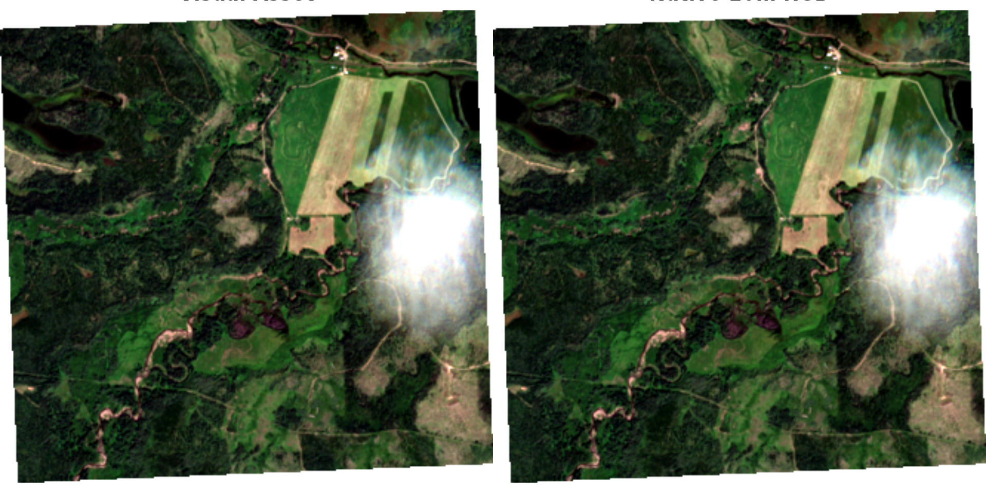
They look basically identical and when we check the resolution we can see that they are equal…
Multi-Year Comparison
Query multiple years and retrieve the latest available ortho (visual asset) from peak growing-season for each year.
years <- seq(2016, 2025, by = 1)

orthos_by_year <- years |>
  purrr::map(function(y) {
    date_time <- paste0(y, "-06-01/", y, "-07-31")

    items <- rstac::stac(stac_url) |>
      rstac::stac_search(
        collections = "sentinel-2-l2a",
        datetime = date_time,
        intersects = sf::st_geometry(aoi)[[1]],
        limit = 10
      ) |>
      rstac::ext_filter(`eo:cloud_cover` <= 20) |>
      rstac::post_request() |>
      rstac::items_fetch() |>
      rstac::items_sign_planetary_computer()

    # Return NULL if no features found for this year
    if (length(items$features) == 0) return(NULL)

    # Sort by datetime descending to get the latest scene
    datetimes <- purrr::map_chr(items$features, ~ .x$properties$datetime)
    latest_idx <- which.max(as.POSIXct(datetimes))

    # Extract the acquisition date for the layer name
    acq_date <- as.Date(datetimes[latest_idx])

    # Get the latest feature's visual asset clipped to AOI
    ortho <- items$features[[latest_idx]] |>
      ngr_spk_stac_calc(asset_a = "visual", asset_b = NULL, calc = NULL, aoi = aoi)

    list(date = acq_date, raster = ortho)
  }) |>
  purrr::compact() |>  # Remove NULLs (years with no data)
  (\(x) purrr::set_names(x, purrr::map_chr(x, ~ as.character(.x$date))))()
#> ℹ read asset_a: S2A_MSIL2A_20160726T192912_R142_T09UXA_20210212T082015
#> ℹ read asset_a: S2A_MSIL2A_20170611T192911_R142_T09UXA_20210209T221512
#> ℹ read asset_a: S2A_MSIL2A_20180726T192911_R142_T09UXA_20201011T201537
#> ℹ read asset_a: S2B_MSIL2A_20190706T192919_R142_T09UXA_20201005T102128
#> ℹ read asset_a: S2B_MSIL2A_20200730T192909_R142_T09UXA_20200818T053857
#> ℹ read asset_a: S2A_MSIL2A_20210730T192911_R142_T09UXA_20210801T050955
#> ℹ read asset_a: S2B_MSIL2A_20220730T192909_R142_T09UXA_20240717T130049
#> ℹ read asset_a: S2A_MSIL2A_20230713T193911_R042_T09UXA_20230714T041240
#> ℹ read asset_a: S2A_MSIL2A_20240717T193901_R042_T09UXA_20240718T023435
#> ℹ read asset_a: S2C_MSIL2A_20250729T192931_R142_T09UXA_20250729T230313
Display the multi-year comparison as toggleable layers on a leaflet map.
map <- leaflet::leaflet() |>
  leaflet::addTiles()

for (dt in names(orthos_by_year)) {
  map <- map |>
    leafem::addRasterRGB(orthos_by_year[[dt]]$raster, group = dt, quantiles = c(0.02, 0.98))
}

map |>
  leaflet::addLayersControl(
    baseGroups = names(orthos_by_year),
    options = leaflet::layersControlOptions(collapsed = FALSE)
  )