Waterfall Creek - 124421 - Monitoring Appendix
PSCIS crossing 124421 on Waterfall Creek is located on 11th Avenue within the Bulkley River watershed group. The culvert at this crossing has been removed by the Gitksan Watershed Authorities, and the site was visited in 2025 under the effectiveness monitoring program.
Background
Waterfall Creek is a tributary of Station Creek, known locally as Mission Creek, which it joins approximately 1.2 km upstream of Highway 16 within the community of New Hazelton. Wilson and Rabnett (2007) report that Xsan Xsagiibil was a Gitxsan fishing site at the mouth of Station Creek (Xsi Gwin Sagiiblax), and ranked the Highway 16 crossing on Station Creek — PSCIS crossing 124420, roughly 2.6 km downstream of 11th Avenue — the highest priority for fish passage rehabilitation in the Bulkley River watershed.
This is a system with an unusually well documented restoration history, compiled in our Phase 1 assessment of these crossings (Irvine [2021] 2022). Coho stocks were lost in the late 1970s following the improper installation of the Highway 16 crossing (Houlden et al. 2001). The Waterfall Creek Stream Rehabilitation Project began in 1990 to reintroduce coho using surplus stock transplanted from Toboggan Creek near Smithers; the Hazelton Elementary Streamkeepers program followed in 1993, and the Chicago Creek Community Environmental Enhancement Society was incorporated in 1995 and developed a hatchery nearby. The hatchery no longer operates, but the effort was considered successful, with coho runs of between 65 and 297 fish documented from 1998 to 2001 (Houlden et al. 2001; Houlden and Donas 2002).
Coho are moved into this reach deliberately. Wilson and Rabnett (2007) describe an annual trap-and-truck operation led by the Society, taking coho from a fence near the confluence with the Bulkley River to Waterfall Creek upstream of Highway 16 — that is, into the reach containing crossing 124421. Whether the operation still runs should be confirmed with the Society, but the reach has been managed as coho habitat for three decades, and the Phase 1 surveys upstream of the confluence rated it valuable rearing habitat for juvenile coho and rainbow trout (Irvine [2021] 2022).
The Phase 1 assessment covered crossing 124421 alongside 124420 and 124422 on the same system (Irvine [2021] 2022). The reach between 124421 and 124422 was considered an important migration corridor, and upstream of 124422, within a residential area of New Hazelton, earlier restoration work placed logs to create riffle-pool breaks and retain gravel — habitat rated critical for coho spawning. PSCIS crossing 124424 lies under the railway approximately 55 m downstream of 11th Avenue; it ranked a barrier under the provincial protocol but is 100% backwatered, which is seldom an obstruction to fish passage. A fall 2017 flood released and redistributed sediment through the system, prompting a fish habitat survey from the Bulkley confluence upstream to the Mile 48 railway crossing (Newman and England 2018).
Crossing Characteristics
Before removal, the structure was a round culvert ranked a barrier to upstream migration under the provincial protocol (MoE 2011). The September 2021 Phase 1 assessment recorded the pipes bent in the middle from road weight and an inlet drop of 0.10 m on both, in a reach described as slow, steady flow through almost wetland habitat above and below the crossing (Irvine [2021] 2022) (Figure 5.19).
The culvert has since been removed. At the 2025 visit the riprap at the site had been buried with soil and seeded, with good regrowth of grasses established, and shrub planting was planned for the fall (Figure 5.20).
my_caption <- paste0("Culvert on Waterfall Creek at PSCIS crossing ", my_site_mon,
                     " on 11th Avenue, photographed in September 2021 before removal.")
knitr::include_graphics("data/photos/124421/before/crossing_all.JPG")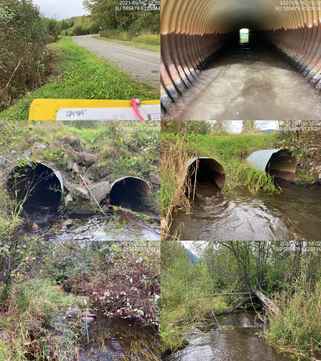
Figure 5.19: Culvert on Waterfall Creek at PSCIS crossing 124421 on 11th Avenue, photographed in September 2021 before removal.
my_caption <- paste0("Waterfall Creek at PSCIS crossing ", my_site_mon,
                     " on 11th Avenue, photographed on 2025-10-04 following removal of the culvert.")
knitr::include_graphics("data/photos/124421/crossing_all.JPG")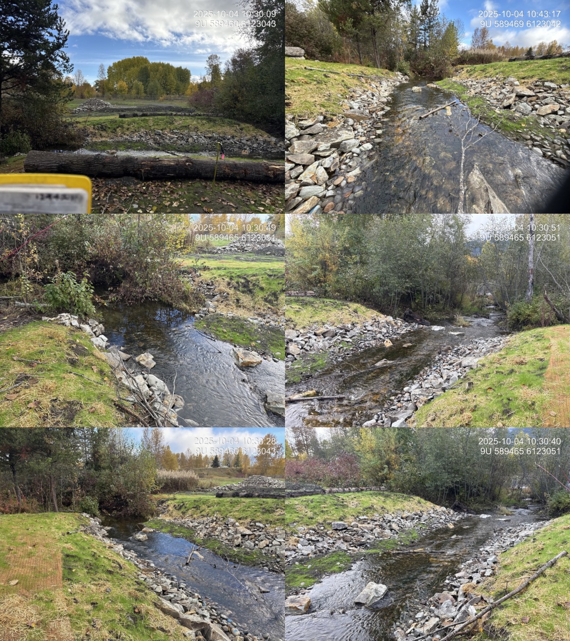
Figure 5.20: Waterfall Creek at PSCIS crossing 124421 on 11th Avenue, photographed on 2025-10-04 following removal of the culvert.
my_caption <- paste0("Revegetation of the buried riprap at PSCIS crossing ", my_site_mon,
                     ", recorded during the ", params$project_year, " effectiveness monitoring visit.")
knitr::include_graphics("data/photos/124421/20251004_104154_NA_revegetation.JPG")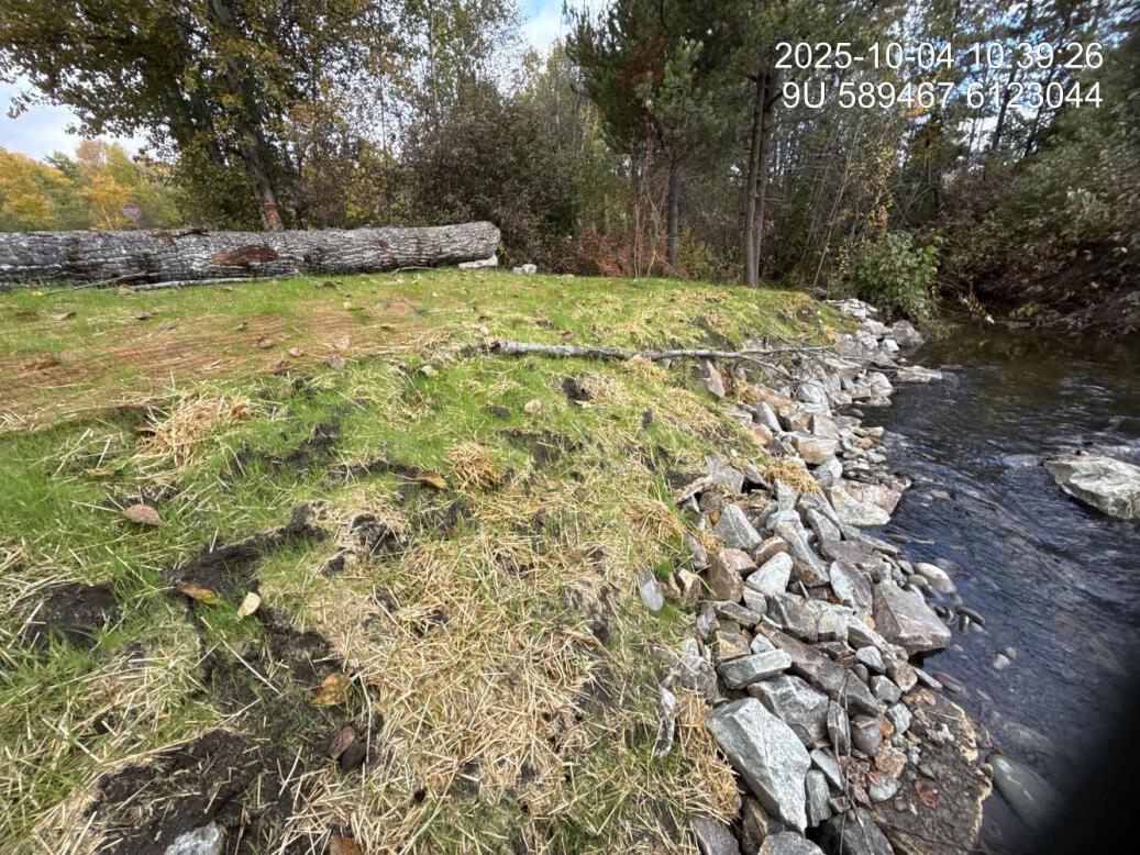
Figure 5.21: Revegetation of the buried riprap at PSCIS crossing 124421, recorded during the 2025 effectiveness monitoring visit.
Monitoring Form
2025 effectiveness monitoring form results are summarized in Table 5.16.
tab_monitoring |>
  dplyr::filter(`Pscis Crossing Id` == my_site_mon) |>
  dplyr::mutate(dplyr::across(dplyr::everything(), as.character)) |>
  tidyr::pivot_longer(
    cols = dplyr::everything(),
    names_to = "Variable",
    values_to = "Value"
  ) |>
  fpr::fpr_kable(
    caption_text = paste0("Summary of effectiveness monitoring form results for site ", my_site_mon,
                          " in ", params$project_year, "."),
    scroll = gitbook_on
)| Variable | Value |
|---|---|
| Pscis Crossing Id | 124421 |
| Stream Name | Waterfall Creek |
| Road Name | 11th Avenue |
| Crossing Subtype | FORD |
| Span | – |
| Width | – |
| Assessment Comment | Culvert was removed by Gitksan Watershed Authorities. Site riprap was buried with dirt and seated with good regrowth of grasses. Shrub planting is planned for this fall. |
| Dewatering Notes | Water is flowing well through construction footprint with no evidence of dewatering |
| Velocity Notes | Velocities through the construction footprint were comparable to riffle-type morphology sections upstream and downstream. Placement of riprap boulders within the wetted channel created localized pockets of reduced velocity suitable for resting. |
| Constriction Notes | Channel widths ranged from 4.5–5m, with wetted width at the time of assessment approximately 4m. The channel did not appear constricted through the construction footprint. |
| Substrate Notes | Channel substrate was composed primarily of cobbles with some strategically placed boulders. Overall composition appeared natural and suitable for the stream. |
| Riparian Notes | Riparian removal to accommodate construction appeared minimal, with shrub planting planned for the fall off 2025. The site was re-vegetating well with a reclamation grass mix and mulch, and much of the armoring rock had been covered with quality topsoil. |
| Flow Depth Notes | Flow depths through the construction footprint appeared suitable, ranging from 5–15cm. Over time, natural stone lines were expected to develop, creating deeper areas as the channel continued to mature. |
| Stability Notes | Site appears stable with ample rock to prevent washouts. |
| Revegetation Notes | Reclamation grasses that were seeded appeared to be growing well, supported by coconut matting and areas where rock had been buried with topsoil. Shrub planting was reportedly planned for the fall 2025. |
| Cover Notes | Strategically placed boulders provided some instream cover, and one piece of woody debris was present at the downstream end of the site. Overhead vegetation within the footprint is expected to provide additional cover as it matures. |
| Maintenance Notes | No maintenance required at the time of assessment however, revegetation activities were not yet complete. |
Habitat
Habitat confirmation assessments were completed at this site in September 2021, before the culvert was removed (Irvine [2021] 2022). Both reaches were rated moderate habitat value, with 120 m surveyed upstream and 50 m downstream, and approximately 1.3 km of upstream habitat length estimated. The site was ranked a moderate priority for remediation.
The upstream reach was described as a slow-moving wetland-type stream with deep glides throughout, instream vegetation, overhanging vegetation and undercut banks, with gradient increasing slightly and substrate changing from fines and organics to small gravel near the top of the survey. The downstream reach was a defined channel widening into a small wetland complex dominated by tall grasses, with high amounts of instream vegetation and muddy substrate.
No fish sampling was conducted at this site in 2021, and no environmental DNA samples were collected here in 2025.
Aerial Imagery
An aerial survey was conducted with a remotely piloted aircraft and the resulting imagery was processed into an orthomosaic available to view and download in Figure 5.22.
knitr::asis_output(ngr::ngr_str_viewer_cog("https://imagery-uav-bc.s3.amazonaws.com/skeena/bulkley/2025/124421_waterfall_11th/odm_orthophoto/odm_orthophoto.tif"))my_caption <- paste0("Orthomosaic of Waterfall Creek at PSCIS crossing ", my_site_mon, ".")
knitr::include_graphics("fig/pixel.png")
Figure 5.22: Orthomosaic of Waterfall Creek at PSCIS crossing 124421.
Discussion
Removing a crossing outright, rather than replacing it, is the most complete form of remediation available and it is uncommon in this program. The 2025 visit found the site stabilising as intended — riprap buried and seeded, grasses established, shrub planting to follow.
The value of the removal is best read against the history of the reach. Coho were lost from this system in the late 1970s to a poorly installed highway crossing, reintroduced from 1990 by a community effort that ran a hatchery and traps and trucks fish past the highway, and the habitat immediately upstream of the former crossing has been rated critical for coho spawning. Removing the 11th Avenue culvert takes out one of the remaining structures on that path, in a reach the 2021 survey considered an important migration corridor.
Recommendations for continued monitoring at this site:
Collect environmental DNA upstream and downstream of the former crossing. This is the lowest-cost way to track which species use the reach as it recovers.
Continue photographic monitoring of the revegetating riprap and the channel through the former crossing, so recovery can be tracked against the shrub planting.
Confirm with the Gitksan Watershed Authorities what the planned shrub planting involved and when it was completed, so the revegetation record reflects the work actually done.
Confirm with the Chicago Creek Community Environmental Enhancement Society whether the trap-and-truck operation still runs, and where fish are released. If coho are still being moved past Highway 16, the removal of this culvert changes what that operation has to bypass.