Comeau Creek - 198916 & 198913 - Appendix
Site Location
BC Freshwater atlas mapping of this watershed is incorrect as the main stream at the confluence with the Skeena River is actually Comeau Creek vs Gershwin Creek - as it is labelled in provincial mapping (Figure 5.7). Gershwin Creek is a much smaller tributary that flows into Comeau Creek approximately 270m downstream of Highway 16 at a location 2.5km upstream from the Comeau Creek/Skeena River confluence. As noted in M. McCarthy (2000) - the mainstem of Comeau Creek deviates from the mapped Comeau Creek stream line approximately 5.3km upstream of the incorrectly mapped confluence of Comeau Creek and the Skeena River and enters the drainage labelled as Gershwin Creek at a location 4.8km upstream of the true Comeau Creek confluence with the Skeena River (see corrected streamline in Figure 5.7).
PSCIS crossing 198916 is located on Comeau Creek on the CN Railway 1.8km upstream of the confluence of Comeau Creek and the Skeena River. PSCIS crossing 198913 is located on Comeau Creek at Highway 16. Comeau Creek flows into Gershwin Creek just downstream of the highway. Both sites are within the Kispiox River watershed group. PSCIS crossing 198916 is owned by CN Rail and 198913 is the responsibility of the Ministry of Transportation and Infrastructure.
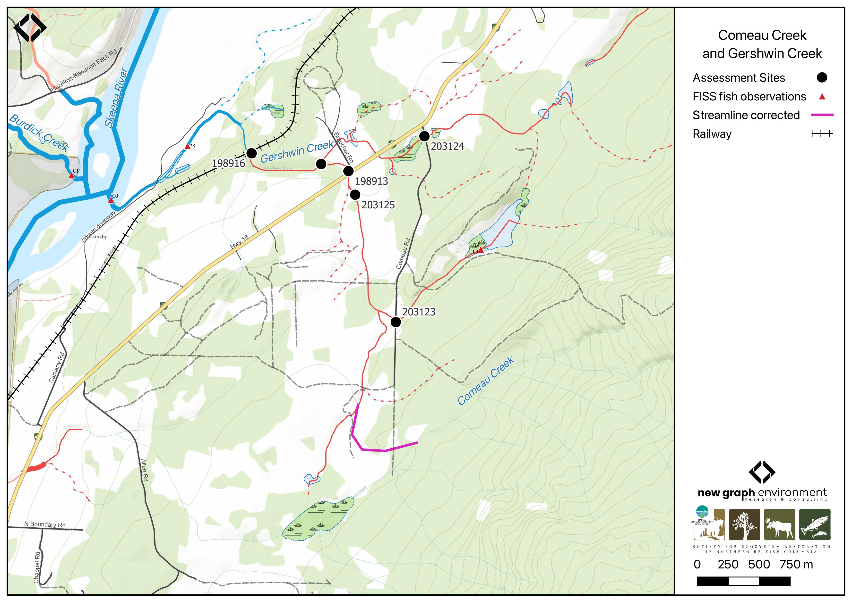
Figure 5.7: Comeau Creek and Gershwin Creek
Background
# # A`r fpr::fpr_my_pscis_info()` is mapped as a
# `r fpr::fpr_my_bcfishpass() |> english::ordinal()` order stream with an
# upstream watershed area of approximately
# `r fpr::fpr_my_wshd()`km^2^. The watershed ranges in elevation from
# a maximum of `r fpr::fpr_my_wshd(col = 'elev_max')`m to
# `r fpr::fpr_my_wshd(col = 'elev_site')`m near the lower crossing (Table
# \@ref(tab:tab-wshd-198916)).
In 1999, M. McCarthy (2000) conducted a detailed survey of Comeau Creek including the area from the confluence with the Skeena River to a point estimated as the upstream limit to fish (7.2km distance). During that survey two pairs of coho salmon were observed spawning at location approximately 100m and 130m upstream of the Skeena River confluence. A 2m high beaver dam located ~50m further upstream was noted as likely limiting migration of both spawning adults and rearing juveniles at that time. M. McCarthy (2000) document the culverts located on the CN Railway and Highway 16 (among others) and note that the CN Railway crossing is likely impassible for fish migrating upstream due to its length (98m) shallow water depths (7cm) and high velocity discharge (2 m/s). Also noted within this study was extensive minnowtrapping upstream of Highway 16 with Dolly Varden and cutthrout trout captured.
M. McCarthy and Fernando (2015) ranked crossing 198916 on the CN Railway as a high priority for restoration and recommend improving upstream fish migration conditions through the installation of baffles and backwatering structures.
In 2023, fish passage assessments were completed on Comeau Creek at PSCIS crossings 198916 and 198913, located on the CN railway and Highway 16, respectively, as well as for Gershwin Creek at PSCIS crossing 198907 on Braucher Road. Assessment data and photos are presented in Irvine and Schick (2023) here. These assessments documented high-value habitat upstream of the railway crossing and fish observed in the outlet pool downstream of the Highway 16 crossing.
Within provincial databases, coho salmon and pink salmon spawning is noted 90m and 750m upstream of the confluence of Comeau Creek and the Skeena River. Additionally, are documented in the lake upstream of the Highway 16 crossing (198913) (Norris [2018] 2024; MoE 2024a).
In 2024, habitat confirmation assessments and fish sampling were conducted upstream and downstream of Comeau Creek PSCIS crossings 198916 and 198913, located on the CN railway and Highway 16, respectively. That same year, two additional crossings on Comeau Road were assessed with fish passage assessments, with results presented in Appendix - Phase 1 Fish Passage Assessment Data and Photos. The first—PSCIS crossing 203124 on Gershwin Creek—was located approximately 100m up Comeau Road from Highway 16. The second—PSCIS crossing 203123 on a tributary to Comeau Creek—was located approximately 1.6km up Comeau Road from the highway. Field observations and review of BC Freshwater Atlas mapping between these two crossings suggest that the lake/wetland area mapped as upstream of crossing 203123, where Dolly Varden and cutthroat trout observations have been recorded, likely drains northwest to Gershwin Creek rather than southeast to Comeau Creek as currently indicated in provincial mapping.
fpr::fpr_table_wshd_sum(site_id = my_site) |>
  fpr::fpr_kable(caption_text = paste0('Summary of derived upstream watershed statistics for PSCIS crossing ', my_site, '.'),
           footnote_text = 'Elev P60 = Elevation at which 60% of the watershed area is above',
           scroll = F)
A map of the watershed is provided in map attachment 093M.101.
# likley bogus
# Although modelling outputs from bcfishpass are presented in Table
# \@ref(tab:tab-culvert-bcfp-198916)).
fpr::fpr_table_bcfp(scroll = gitbook_on)
Stream Characteristics at Crossings 198916 and 198913
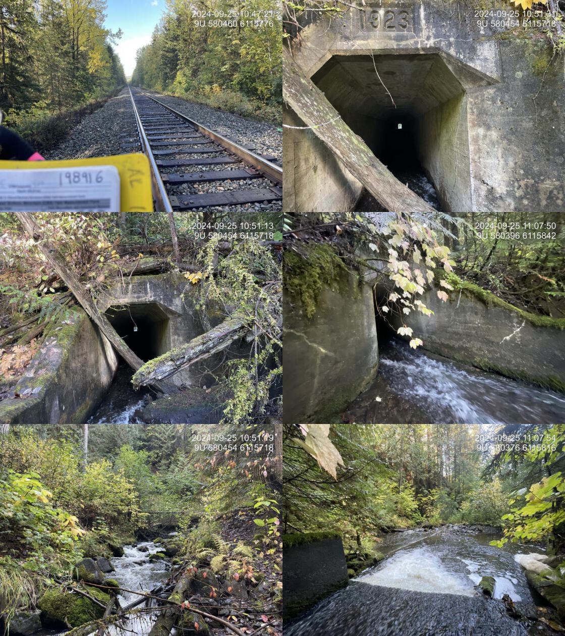
At the time of assessment, PSCIS crossing 198916 on the CN Railway was un-embedded, non-backwatered and ranked as a barrier to upstream fish passage according to the provincial protocol (MoE 2011) (Table 5.3). Constructed in the 1920s, this crossing is a concrete box culvert approximately 100 m in length, located beneath the CN railway with approximately 30–40 m of fill above it. It features a 0.45m outlet drop that adult fish could likely overcome but is presumed to act as a barrier to juvenile fish due to high velocities caused by the culvert’s steep slope (6%) and shallow flow depths.
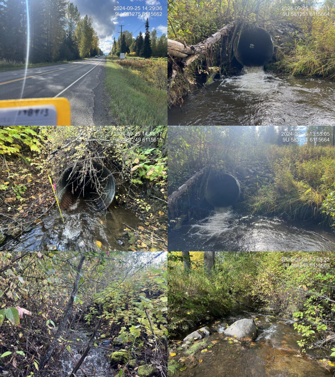
PSCIS crossing 198913 on Highway 16 was un-embedded, non-backwatered and ranked as a barrier to upstream fish passage according to the provincial protocol (MoE 2011) (Table 5.4). The crossing had a 0.35m outlet drop and a 0.85m deep outlet pool, suggesting the culvert is undersized for the stream.
Water temperature was 8\(^\circ\)C, pH was 8.1 and conductivity was 305 uS/cm.
Data and photos for Comeau Road crossings assessed with fish passage assessments are presented in Appendix - Phase 1 Fish Passage Assessment Data and Photos. For PSCIS crossing 203124 on Gershwin Creek located approximately 100m up the road from the highway - debris was partially clogging the pipe inlet had caused water to pool upstream of the road with a very small defined channel downstream (<1m). The second crossing - PSCIS 203123 - on a tributary to Comeau Creek - was located approximately 1.6km up the road from the highway. At this location the stream had no visible channel.
# fpr::fpr_table_cv_summary_memo()

# See issue https://github.com/NewGraphEnvironment/mybookdown-template/issues/65
lfpr_table_cv_summary_memo()| Location and Stream Data |
|
Crossing Characteristics | – |
|---|---|---|---|
| Date | 2024-09-25 | Crossing Sub Type | Concrete Box |
| PSCIS ID | 198916 | Diameter (m) | 1.5 |
| External ID | – | Length (m) | 99 |
| Crew | LS JD | Embedded | No |
| UTM Zone | 9 | Depth Embedded (m) | – |
| Easting | 580463 | Resemble Channel | No |
| Northing | 6115769 | Backwatered | No |
| Stream | Comeau Creek | Percent Backwatered | – |
| Road | Railway | Fill Depth (m) | 9.9 |
| Road Tenure | CN Rail | Outlet Drop (m) | 0.45 |
| Channel Width (m) | 4.4 | Outlet Pool Depth (m) | 0.35 |
| Stream Slope (%) | 4.4 | Inlet Drop | No |
| Beaver Activity | No | Slope (%) | 6 |
| Habitat Value | Medium | Valley Fill | Deep Fill |
| Final score | 42 | Barrier Result | Barrier |
| Fix type | Replace with New Open Bottom Structure | Fix Span / Diameter | 35.5 |
| Comments: The concrete box culvert is approximately 100m long beneath a railway crossing, with about 30 - 40m of fill above it. A swift current flows through the culvert, and installing baffles could improve fish passage. Fish sampling captured cutthroat trout and Dolly Varden downstream of the crossing, and Dolly Varden upstream. There is a moderate outlet drop, but adult fish could likely move upstream. The habitat upstream features good flow through a steeper section with a healthy, mature mixed riparian forest, stable banks, and gravel pockets suitable for spawning coho, Dolly Varden, and cutthroat trout. Downstream, abundant boulders create step pools alongside frequent large woody debris, though high flows limited suitable fish habitat during the survey. Although construction would be expensive and challenging, this site is a high priority for restoration follow-up. This crossing is located on Comeau Creek, which is incorrectly mapped in the BC Freshwater Atlas as flowing southwest into the Skeena River. In reality, it flows southwest then turns north, crossing highway 16 and the CN railway (this crossing) before joining the Skeena River. See the 2024 report for a map of the corrected streamline.Culvert length 100 m but changed to 99.0 m to meet submission requirements.Fill depth 30 m but changed to 9.9 m to meet submission requirements. | |||
| Photos: From top left clockwise: Road/Site Card, Barrel, Outlet, Downstream, Upstream, Inlet. | |||
|
# fpr::fpr_table_cv_summary_memo(site = my_site2, site_photo_id = my_site2)

# See issue https://github.com/NewGraphEnvironment/mybookdown-template/issues/65
lfpr_table_cv_summary_memo(site = my_site2, site_photo_id = my_site2)| Location and Stream Data |
|
Crossing Characteristics | – |
|---|---|---|---|
| Date | 2024-09-25 | Crossing Sub Type | Round Culvert |
| PSCIS ID | 198913 | Diameter (m) | 1.5 |
| External ID | – | Length (m) | 40 |
| Crew | AI JO | Embedded | No |
| UTM Zone | 9 | Depth Embedded (m) | – |
| Easting | 581250 | Resemble Channel | No |
| Northing | 6115660 | Backwatered | No |
| Stream | Comeau Creek | Percent Backwatered | – |
| Road | Highway 16 | Fill Depth (m) | 2.5 |
| Road Tenure | MOTi | Outlet Drop (m) | 0.35 |
| Channel Width (m) | 5 | Outlet Pool Depth (m) | 0.85 |
| Stream Slope (%) | 3 | Inlet Drop | No |
| Beaver Activity | No | Slope (%) | 3 |
| Habitat Value | Medium | Valley Fill | Deep Fill |
| Final score | 42 | Barrier Result | Barrier |
| Fix type | Replace with New Open Bottom Structure | Fix Span / Diameter | 15 |
| Comments: There is a deep outlet pool, suggesting the culvert is undersized for the stream. High-quality gravels were present at the pool’s outlet, and upstream of the crossing, there was high-value habitat with frequent overwintering pools, spawning gravels, and adequate riparian cover with large cottonwoods throughout. This site was part of a habitat confirmation assessment, with the stream surveyed from the downstream railway crossing up to this location and an additional 600m upstream. Downstream, crossing 198916 consists of a large, long box culvert beneath the railway with minimal flow depth and a swift current, making it unlikely that fish from the mainstem of the Skeena River can access this site until the railway barrier is addressed. Fish sampling upstream of the highway captured Dolly Varden. This crossing is located on Comeau Creek, which is incorrectly mapped in the BC Freshwater Atlas as flowing southwest into the Skeena River. In reality, it flows southwest then turns north, crossing highway 16 (this crossing) and the CN railway before joining the Skeena River. See the 2024 report for a map of the corrected streamline. MoTi chris_culvert_id: 8300872 | |||
| Photos: From top left clockwise: Road/Site Card, Barrel, Outlet, Downstream, Upstream, Inlet. | |||
|
Stream Characteristics Downstream of Crossing 198916
The stream was surveyed downstream from crossing 198916 for 300m . The stream contained numerous boulders forming step pools; however, moderate flows at the time of assessment limited the availability of pools suitable for fish. The first pool suitable for overwintering fish, with adequately reduced flow, was located approximately 250m downstream of the culvert. There were occasional gravels suitable for spawning and frequent large woody debris, which contributed to the formation of additional steps. (Figure 5.10). The dominant substrate was cobbles with gravels sub-dominant.Total cover amount was rated as moderate with boulders dominant. Cover was also present as small woody debris, large woody debris, and overhanging vegetation.The average channel width was 5.9m, the average wetted width was 3.7m, and the average gradient was 5.1%. The habitat was rated as medium value suitable for salmonid rearing and spawning.
Stream Characteristics Upstream of Crossing 198916 and Downstream of Crossing 198913
The stream was surveyed from the railway crossing (198916) upstream to the Highway 16 crossing (198913), a distance of approximately 900 m (Figures 5.11 - 5.12). A large woody debris jam was observed approximately 250m upstream of the railway crossing, creating a 17% gradient over a 9m section due to a fallen tree. The stream maintained good flow through this steeper section, supported by a healthy, mature mixed riparian forest that stabilized the banks. The dominant substrate was cobbles with boulders sub-dominant.Total cover amount was rated as moderate with undercut banks dominant. Cover was also present as small woody debris, boulders, and overhanging vegetation.The average channel width was 4.4m, the average wetted width was 3.3m, and the average gradient was 4.4%. The habitat was rated as medium value and contained occasional pockets of gravels suitable for spawning by coho salmon, Dolly Varden, and cutthroat trout.
Stream Characteristics Upstream of Crossing 198913
The stream was surveyed upstream from crossing 198913 - located on Highway 16 for 600m. The stream had frequent pools suitable for overwintering fish, with spawning gravels present despite a significant amount of fines. In the ~200 m section just upstream of the crossing, the stream maintained a low gradient and flowed through agricultural fields with mature cottonwood riparian cover throughout the entire area surveyed (Figure 5.13).The dominant substrate was gravels with fines sub-dominant.Total cover amount was rated as abundant with large woody debris dominant. Cover was also present as small woody debris, boulders, deep pools, and overhanging vegetation.The average channel width was 6.0m, the average wetted width was 4m, and the average gradient was 2.8%. The habitat was rated as high value for salmonid rearing an spawning.
Fish Sampling
Electrofishing was conducted on Comeau Creek below and above the railway crossing (PSCIS 198916) as well as upstream and downstream of the crossing on Highway 16 (PSCIS 198913). Comeau Creek railway crossing (PSCIS 198916) results are summarised in Tables 5.6 - 5.8 and Figure 5.8. A total of 35 fish were captured downstream including Dolly Varden and cutthroat trout, and 3 Dolly Varden were captured upstream (Figure 5.14).
Electrofishing results for upstream and downstream of the crossing on Highway 16 (PSCIS 198913) are summarised in Tables 5.7 - 5.9 and Figure 5.9. A total of 12 fish were captured downstream including Dolly Varden and cutthroat trout, and 9 Dolly Varden were captured upstream (Figure 5.15).
Structure Remediation and Cost Estimate
Should restoration/maintenance activities proceed, replacement of the railway crossing (198916) with a bridge or open bottom structure is estimated to cost $ 26,625,000. As noted in M. McCarthy and Fernando (2015) - installing baffles within the culvert would likely improve fish passage conditions as a less expensive interim solution.
Until the downstream railway crossing is upgraded, replacement of the upstream crossing on Highway 16 (198913) is not recommended. If the downstream crossing is upgraded, the Highway 16 crossing could be replaced with a bridge spanning 15m. At the time of reporting in 2025, the estimated cost for the replacement was $ 11,250,000.
Conclusion
PSCIS crossings 198916 and 198913 are located on Comeau Creek which provides medium to high-value habitat suitable for coho salmon, Dolly Varden, and cutthroat trout. Conservative estimates indicate approximately 2.3km of mainstem habitat upstream of the railway crossing likely suitable for coho rearing.
PSCIS crossing 198916 on the CN Railway is an exceptionally long concrete box culvert under 30–40m of fill. It is likely a barrier to upstream migration to all species and life stages due to its extensive length, 0.45m outlet drop, steep slope, shallow flows and high flow velocities within the structure. The site was rated as a high priority for replacement - however, given the significant cost and scale of such a project, baffle installation and backwatering could be explored as an alternate interim solution to improve fish passage conditions. Replacement of PSCIS crossing 198913 on Highway 16 could be explored if upgrades to the downstream railway crossing are planned.
Although the size of the stream and gradients observed within the areas of Comeau Creek surveyed in 2024 indicate the stream is suitable for coho, none were captured downstream of the railway via electrofishing indicating that the species was not utilizing the areas fished at the time of sampling. These observations align with reporting from M. McCarthy (2000) - which noted beaver activity likely blocking upstream coho migration near the confluence with the Skeena River. M. McCarthy (2000) recommend efforts be undertaken to trasfer coho salmon juveniles to upstream of the beaver dam with the intent of increasing coho productivity in the stream. Provided beaver dams are present and coho spawners still utilize this system, implementing this recommendation could be considered. A full assessment of the area between the railway crossing and the confluence of the Skeena River is recommended during the fall to scope for coho and pink spawners and update the state of knowledge regarding natural and man-made barriers in this section of stream.
tab_hab_summary |>
  dplyr::filter(Site %in% c(my_site, my_site2)) |>
  fpr::fpr_kable(caption_text = paste0("Summary of habitat details for PSCIS crossings ", my_site, " and ", my_site2, "."),
scroll = F) | Site | Location | Length Surveyed (m) | Average Channel Width (m) | Average Wetted Width (m) | Average Pool Depth (m) | Average Gradient (%) | Total Cover | Habitat Value |
|---|---|---|---|---|---|---|---|---|
| 198913 | Upstream | 600 | 6.0 | 4.0 | 0.6 | 2.8 | abundant | high |
| 198916 | Downstream | 300 | 5.9 | 3.7 | 0.3 | 5.1 | moderate | medium |
| 198916 | Upstream | 900 | 4.4 | 3.3 | 0.4 | 4.4 | moderate | medium |
| site | passes | ef_length_m | ef_width_m | area_m2 | enclosure |
|---|---|---|---|---|---|
| 198916_ds_ef1 | 1 | 34 | 3.1 | 105.4 | partial enclosure |
| 198916_ds_ef2 | 1 | 7 | 5.8 | 40.6 | partial enclosure |
| 198916_us_ef1 | 1 | 43 | 3.4 | 146.2 | partial enclosure |
| site | passes | ef_length_m | ef_width_m | area_m2 | enclosure |
|---|---|---|---|---|---|
| 198913_ds_ef1 | 1 | 7 | 6.0 | 42 | partial enclosure |
| 198913_ds_ef2 | 1 | 20 | 3.3 | 66 | open |
| 198913_us_ef1 | 1 | 30 | 3.0 | 90 | partial enclosure |
| local_name | species_code | life_stage | catch | density_100m2 | nfc_pass |
|---|---|---|---|---|---|
| 198916_ds_ef1 | Cutthroat Trout | adult | 1 | 0.9 | FALSE |
| 198916_ds_ef1 | Cutthroat Trout | fry | 4 | 3.8 | FALSE |
| 198916_ds_ef1 | Cutthroat Trout | juvenile | 4 | 3.8 | FALSE |
| 198916_ds_ef1 | Cutthroat Trout | parr | 8 | 7.6 | FALSE |
| 198916_ds_ef1 | Dolly Varden | adult | 1 | 0.9 | FALSE |
| 198916_ds_ef1 | Dolly Varden | juvenile | 1 | 0.9 | FALSE |
| 198916_ds_ef2 | Cutthroat Trout | adult | 1 | 2.5 | FALSE |
| 198916_ds_ef2 | Cutthroat Trout | fry | 3 | 7.4 | FALSE |
| 198916_ds_ef2 | Cutthroat Trout | juvenile | 3 | 7.4 | FALSE |
| 198916_ds_ef2 | Cutthroat Trout | parr | 5 | 12.3 | FALSE |
| 198916_ds_ef2 | Dolly Varden | adult | 2 | 4.9 | FALSE |
| 198916_ds_ef2 | Dolly Varden | fry | 1 | 2.5 | FALSE |
| 198916_ds_ef2 | Dolly Varden | juvenile | 1 | 2.5 | FALSE |
| 198916_us_ef1 | Dolly Varden | parr | 3 | 2.1 | FALSE |
|
* nfc_pass FALSE means fish were captured in final pass indicating more fish of this species/lifestage may have remained in site. Mark-recaptured required to reduce uncertainties. |
| local_name | species_code | life_stage | catch | density_100m2 | nfc_pass |
|---|---|---|---|---|---|
| 198913_ds_ef1 | Cutthroat Trout | adult | 1 | 2.4 | FALSE |
| 198913_ds_ef1 | Dolly Varden | adult | 1 | 2.4 | FALSE |
| 198913_ds_ef1 | Dolly Varden | fry | 1 | 2.4 | FALSE |
| 198913_ds_ef1 | Dolly Varden | juvenile | 3 | 7.1 | FALSE |
| 198913_ds_ef2 | Cutthroat Trout | adult | 1 | 1.5 | FALSE |
| 198913_ds_ef2 | Dolly Varden | fry | 1 | 1.5 | FALSE |
| 198913_ds_ef2 | Dolly Varden | juvenile | 3 | 4.5 | FALSE |
| 198913_ds_ef2 | Dolly Varden | parr | 1 | 1.5 | FALSE |
| 198913_us_ef1 | Dolly Varden | fry | 1 | 1.1 | FALSE |
| 198913_us_ef1 | Dolly Varden | juvenile | 3 | 3.3 | FALSE |
| 198913_us_ef1 | Dolly Varden | parr | 5 | 5.6 | FALSE |
|
* nfc_pass FALSE means fish were captured in final pass indicating more fish of this species/lifestage may have remained in site. Mark-recaptured required to reduce uncertainties. |
my_caption <- paste0('Densites of fish (fish/100m2) captured upstream and downstream of PSCIS crossing ', my_site, '.')

fpr::fpr_plot_fish_box() 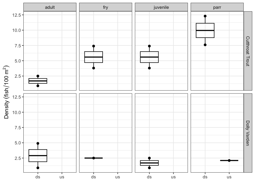
Figure 5.8: Densites of fish (fish/100m2) captured upstream and downstream of PSCIS crossing 198916.
my_caption <- paste0('Densites of fish (fish/100m2) captured upstream and downstream of PSCIS crossing ', my_site2, '.')

fpr::fpr_plot_fish_box(sit = my_site2) 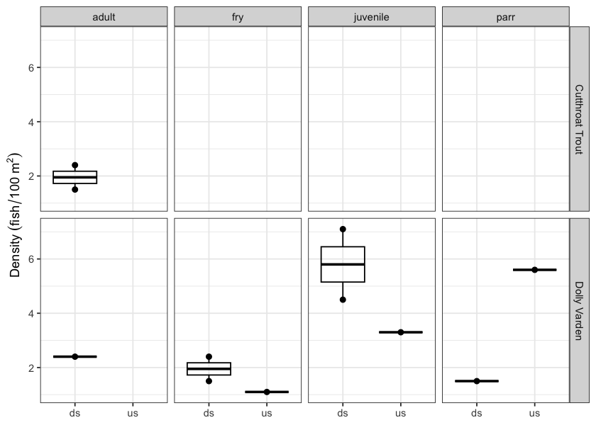
Figure 5.9: Densites of fish (fish/100m2) captured upstream and downstream of PSCIS crossing 198913.
my_photo1 = fpr::fpr_photo_pull_by_str(str_to_pull = 'ds_typical_1_')

my_caption1 = paste0('Typical habitat downstream of PSCIS crossing ', my_site, '.')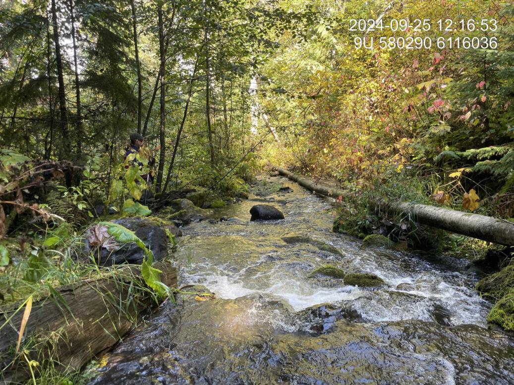
Figure 5.10: Typical habitat downstream of PSCIS crossing 198916.
my_photo2 = fpr::fpr_photo_pull_by_str(str_to_pull = 'us_typical_1')

my_caption2 = paste0('Typical habitat upstream of PSCIS crossing ', my_site, '.')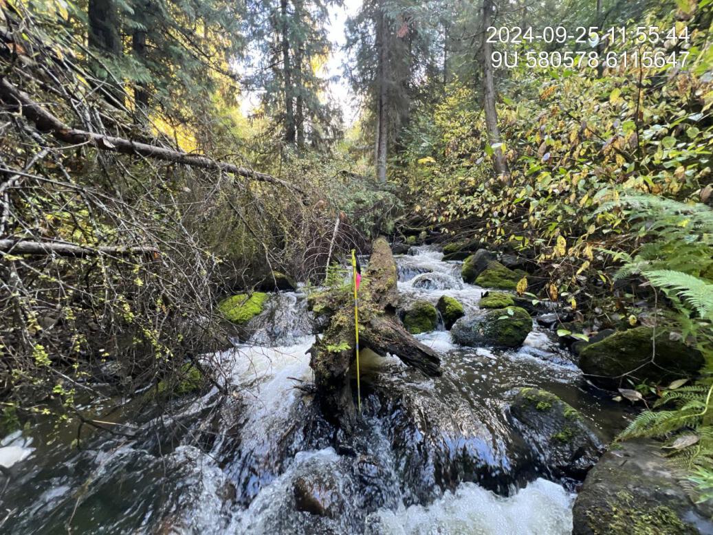
Figure 5.11: Typical habitat upstream of PSCIS crossing 198916.
my_caption <- paste0('Left: ', my_caption1, ' Right: ', my_caption2)

knitr::include_graphics(my_photo1)
knitr::include_graphics("fig/pixel.png")
knitr::include_graphics(my_photo2)
my_photo1 = fpr::fpr_photo_pull_by_str(site = my_site, str_to_pull = 'us_pool')
my_caption1 = paste0('Typical habitat downstream of PSCIS crossing ', my_site2, '.')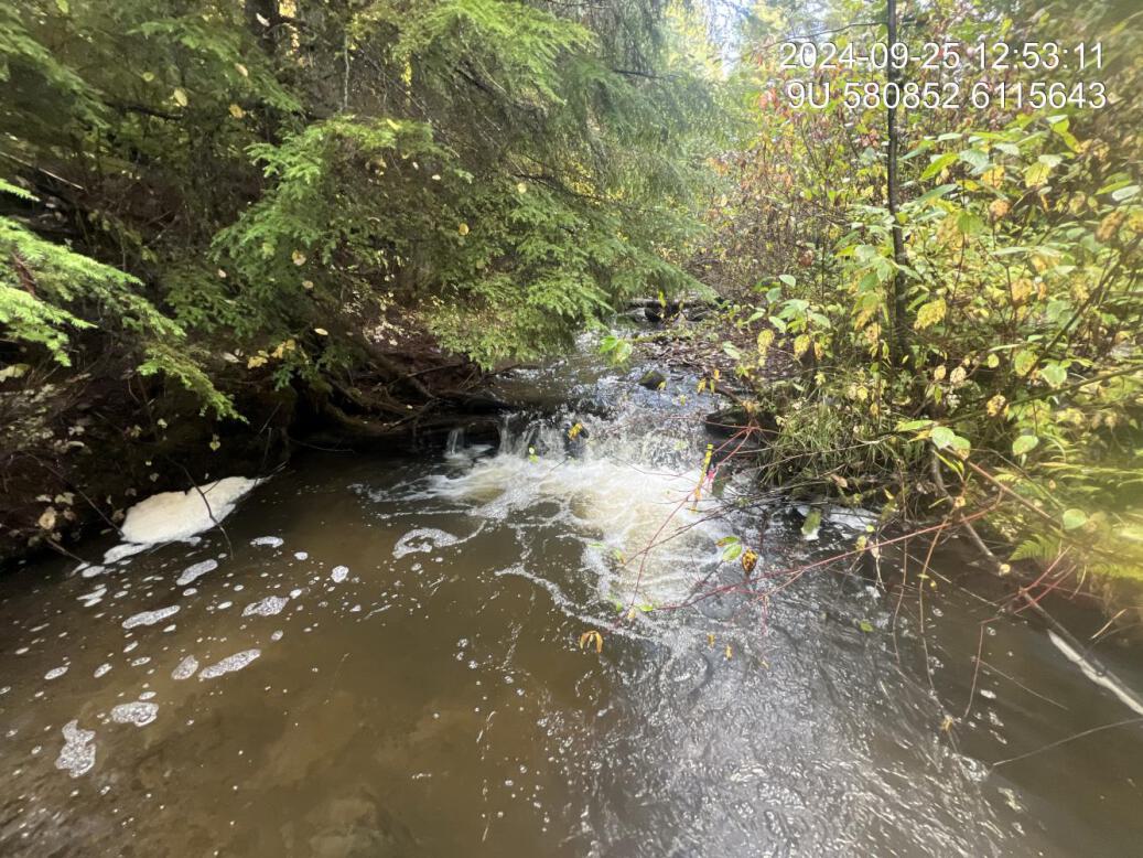
Figure 5.12: Typical habitat downstream of PSCIS crossing 198913.
my_photo2 = fpr::fpr_photo_pull_by_str(site = my_site2, str_to_pull = 'us_typical_2')

my_caption2 = paste0('Typical habitat upstream of PSCIS crossing ', my_site2, '.')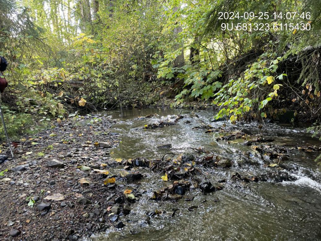
Figure 5.13: Typical habitat downstream of PSCIS crossing 198913.
my_caption <- paste0('Left: ', my_caption1, ' Right: ', my_caption2)

knitr::include_graphics(my_photo1)
knitr::include_graphics("fig/pixel.png")
knitr::include_graphics(my_photo2)
my_photo1 = fpr::fpr_photo_pull_by_str(str_to_pull = 'fish_1')
my_caption1 = paste0('Cutthroat trout captured downstream of crossing ', my_site, '.')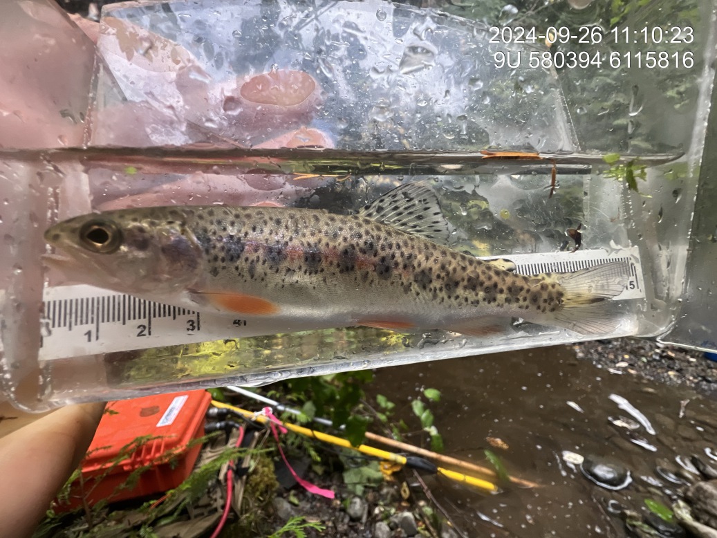
Figure 5.14: Cutthroat trout captured downstream of crossing 198916.
my_photo2 = fpr::fpr_photo_pull_by_str(site = my_site2, str_to_pull = 'fish_1')

my_caption2 = paste0('Dolly varden with captured downstream of crossing ', my_site2, '.')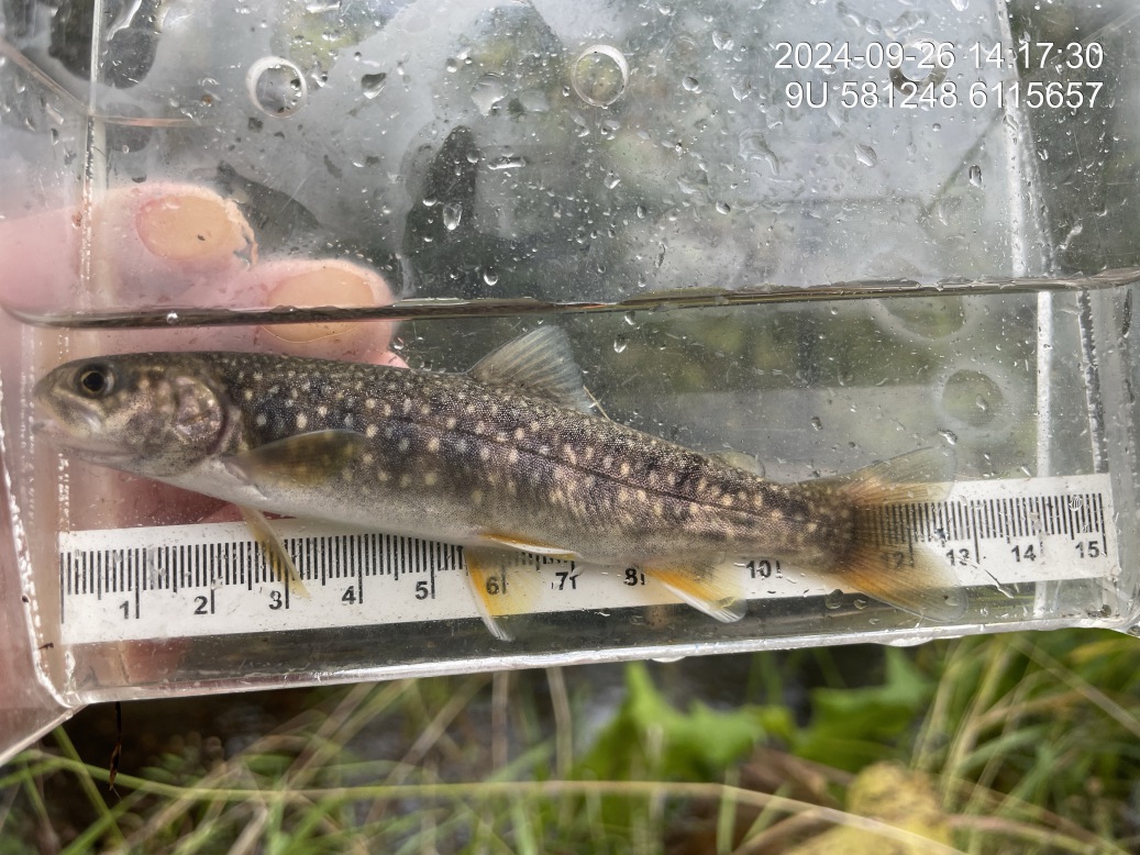
Figure 5.15: Dolly varden with captured downstream of crossing 198913.
my_caption <- paste0('Left: ', my_caption1, ' Right: ', my_caption2)

knitr::include_graphics(my_photo1)
knitr::include_graphics("fig/pixel.png")
knitr::include_graphics(my_photo2)