Taman Creek - 197967 - Appendix
Site Location
PSCIS crossing 197967 is located on the Bulkley River approximately 22.5km east of Topley, BC within the Bulkley River watershed group. The site is situated on Highway 16, approximately 2.5km upstream from Bulkley Lake. Although the stream is named the Bulkley River in the BC Freshwater Atlas, the stream at the highway is commonly referred to as Taman Creek (including on highway signage) as Taman Creek flows into this stream approximately 750m upstream of the highway. The culvert is the responsibility of the Ministry of Transportation and Infrastructure (chris_hwy_structure_road_id 33227).
Background
Detailed background for this site is available in Irvine ([2021] 2022) related to the habitat confirmation conducted in 2021 which can be found here. A map of the watershed is provided in map attachment 093L.115.
Between 2022 and 2024, the Ministry of Transportation and Infrastructure contracted Enviro-Ex Contracting Ltd. to replace the crossing with an extensive streambed simulation structure at a cost of $16,000,000 (Link 2023). The 3m wide un-embedded round culvert was replaced with a 5.6m wide fully embedded round streambed simulation culvert.
Monitoring
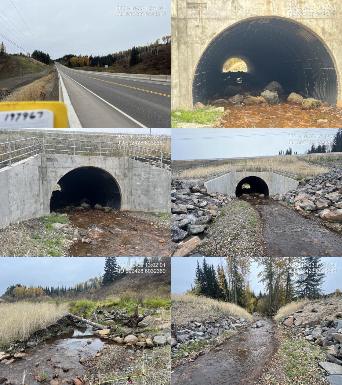
In 2024, crews revisited the site for monitoring purposes, with results summarised in Tables @ref(tab:tab-monitoring-197967 - 5.2). The structure was well-constructed, with nearly 2m of embedded material within the new structure consisting of large boulders, cobbles, and gravels. Upstream, woody debris and boulder structures were cabled together within the reconstructed stream channel to provide habitat complexity and bank stabilization (Figure 5.5). This large-scale construction project involved substantial fill, extending for approximately 60m downstream and over 200m upstream.
Photos showing a comparison of the culvert assessment conducted in 2021 versus the completed replacement structure in 2024 are presented in Figure 5.6 and Table 5.2.
tab_monitoring |>
  dplyr::filter(`Pscis Crossing Id` == my_site) |>
  dplyr::mutate(across(everything(), as.character)) |>
  tidyr::pivot_longer(
    cols = everything(),  # Select all columns
    names_to = "Parameter",  # Column names become values in this column
    values_to = "Description"  # Data values go into this column
  ) |>
  # remove "notes" from Parameter column
  dplyr::mutate(Parameter = stringr::str_replace_all(Parameter, " Notes", "")) |>
  fpr::fpr_kable(caption_text = paste0('Summary of monitoring metric results for site ', my_site, '.'),
scroll = gitbook_on)| Parameter | Description |
|---|---|
| Pscis Crossing Id | 197967 |
| Stream Name | Taman Creek |
| Road Name | Highway 16 |
| Crossing Subtype | ROUND |
| Span | 5.6 |
| Width | 40 |
| Assessment Comment | This is a brand-new replacement structure, extremely well built with extensive embedment that includes numerous large boulders, cobbles, and gravel. The multiplate round structure is embedded nearly 2 m. Upstream, woody debris and boulder structures are cabled together for added stability. This massive construction project involved a substantial amount of fill extending 60 m downstream and over 200 m upstream. The site now offers migration conditions significantly better than before. |
| Dewatering | No dewatering |
| Velocity | Velocity appeared reasonable, with a low gradient effectively connecting upstream and downstream sections. The boulders placed in the culvert, along with cabled woody debris and boulder structures upstream, would help reduce velocity and enhance habitat complexity over time. |
| Constriction | The culvert diameter was wide (5.6m) and did not appear to be constricting the channel. |
| Substrate | The culvert had extensive embedment of natural substrate materials, including large boulders, cobbles, and gravels. The substrates within the culvert closely matched those observed upstream and downstream. |
| Riparian | Some riparian vegetation was removed, but it appeared to have been replanted with grasses. The riparian area upstream on the right bank remained the most intact and similar to its natural state. The channelized banks directly upstream and downstream of the culvert, for approximately 50m, were reinforced with riprap, with no apparent riparian planting or fill covering the riprap.If future work is considered at this site, additional re-vegetation is recommended, including planting willow whips into the riprap and increasing vegetation on the stream banks to improve overhead cover for fish. |
| Flow Depth | Flow depths were adequate, and at higher flows, deeper sections would likely form behind the boulders and chained logs.NULL |
| Stability | The structure was well built, with the road column extensively reinforced with fill. Road runoff areas along the embankment were armored with rock for added stability. |
| Revegetation | There did not appear to be significant re-vegetation efforts, as much of the riprap remained exposed and only grasses seemed to have been planted. More effort could have been directed toward re-vegetation; however, the overall condition of the riparian area was adequate. If future work is considered at this site, additional re-vegetation is recommended, including planting willow whips into the riprap and increasing vegetation on the stream banks to improve overhead cover for fish. |
| Cover | The boulders placed in the culvert, along with the woody debris and boulder structures cabled together upstream, will provide cover over time. However, overhead cover was sparse within the construction footprint, with no signs of vegetative planting to enhance cover.If future work is considered at this site, additional re-vegetation is recommended, including planting willow whips into the riprap and increasing vegetation on the stream banks to improve overhead cover for fish. |
| Maintenance | No maintenance required. |
# fpr::fpr_table_cv_summary_memo(dat = pscis_reassessments)

# See issue https://github.com/NewGraphEnvironment/mybookdown-template/issues/65
lfpr_table_cv_summary_memo(dat = pscis_reassessments)| Location and Stream Data |
|
Crossing Characteristics | – |
|---|---|---|---|
| Date | 2024-10-03 | Crossing Sub Type | Round Culvert |
| PSCIS ID | 197967 | Diameter (m) | 5.6 |
| External ID | – | Length (m) | 40 |
| Crew | AI | Embedded | Yes |
| UTM Zone | 9 | Depth Embedded (m) | 2 |
| Easting | 692426 | Resemble Channel | Yes |
| Northing | 6032341 | Backwatered | No |
| Stream | Taman Creek | Percent Backwatered | – |
| Road | Highway 16 | Fill Depth (m) | 7 |
| Road Tenure | MoTi | Outlet Drop (m) | 0 |
| Channel Width (m) | 5.5 | Outlet Pool Depth (m) | 0 |
| Stream Slope (%) | 2 | Inlet Drop | No |
| Beaver Activity | Yes | Slope (%) | 3 |
| Habitat Value | Medium | Valley Fill | Deep Fill |
| Final score | 16 | Barrier Result | Potential |
| Fix type | Replace with New Open Bottom Structure | Fix Span / Diameter | 27 |
| Comments: This is a brand-new replacement structure, extremely well built with extensive embedment that includes numerous large boulders, cobbles, and gravel. The crossing is passable to fish. The multiplate round structure is embedded nearly 2m. Upstream, woody debris and boulder structures are cabled together providing habitat and added stability. This massive construction project involved a substantial amount of fill extending 60m downstream and over 200m upstream. Monitoring work was conducted and is included in the 2024 report. MoTi chris_culvert_id: 2076452 | |||
| Photos: From top left clockwise: Road/Site Card, Barrel, Outlet, Downstream, Upstream, Inlet. | |||
|
Conclusion
In 2024, conditions for upstream fish passage through the highway crossing at Taman Creek was greatly improved through installation of a streambed simulation structure featuring a large culvert width, embedded natural streambed substrates, and the addition of well designed habitat features within the reconstructed channel. Future monitoring of the site could repeat monitoring metrics conducted in 2024, track morphological changes to the channel in the years following construction (via drone generated elevation models or lidar) and include fish sampling and/or eDNA presence surveys to understand fish use upstream and downstream of the crossing.
my_photo1 = fpr::fpr_photo_pull_by_str(str_to_pull = 'us_logs_')

my_caption1 = paste0('Woody debris and boulder structures located upstream of ', my_site, ' in 2024.')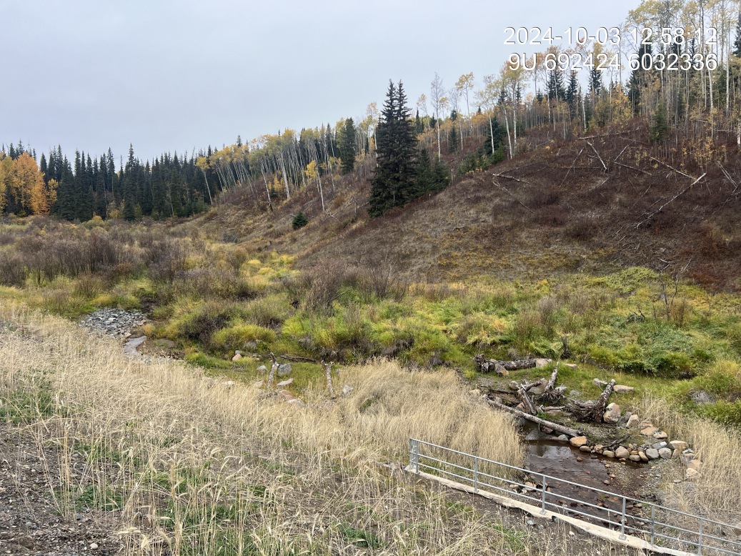
Figure 5.5: Woody debris and boulder structures located upstream of 197967 in 2024.
my_photo2 = fpr::fpr_photo_pull_by_str(str_to_pull = 'crossing_all_2021')

my_caption2 = paste0('Photos of crossing ', my_site, ' in 2021.')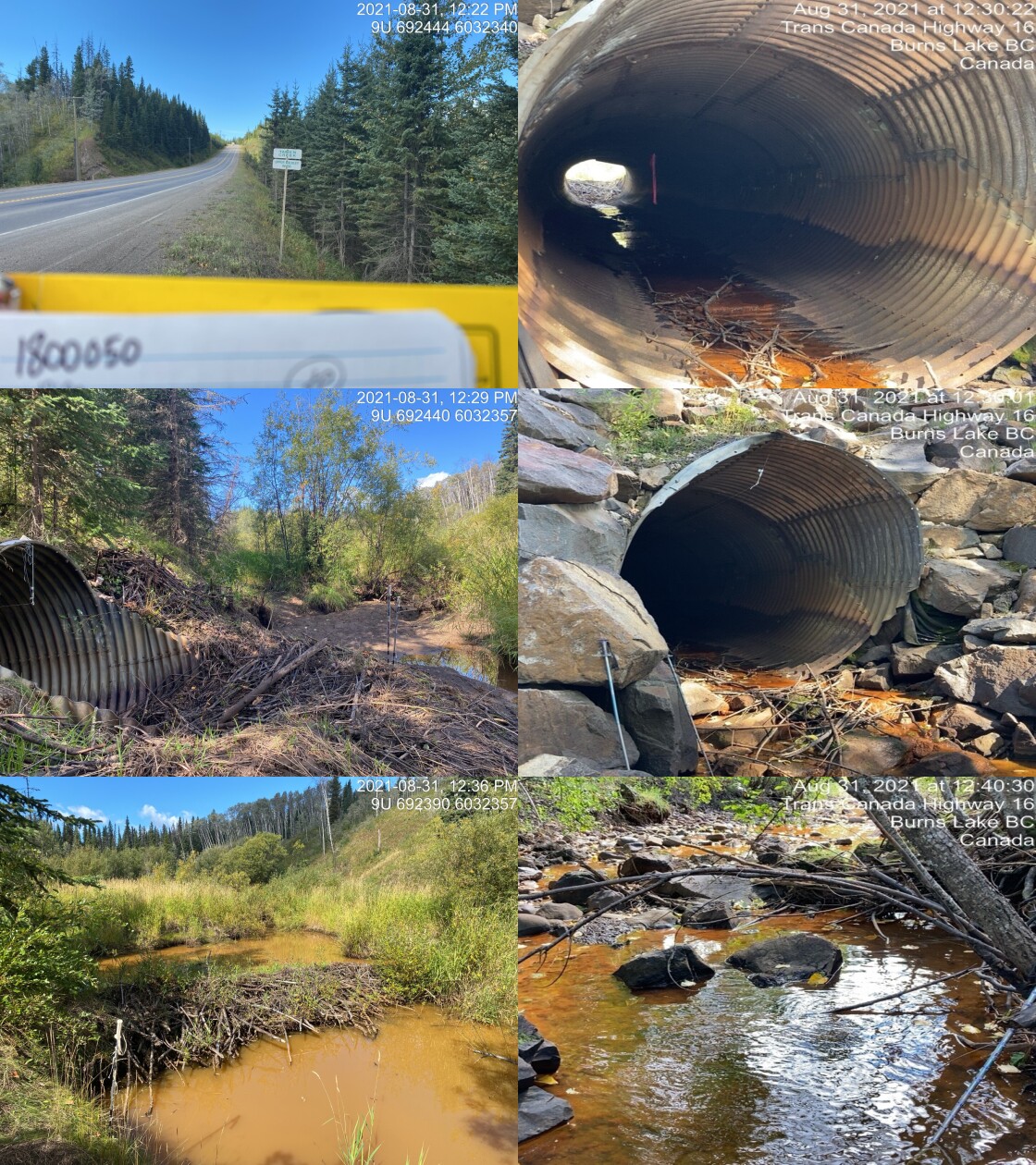
Figure 5.6: Photos of crossing 197967 in 2021.
my_caption <- paste0('Left: ', my_caption1, ' Right: ', my_caption2)

knitr::include_graphics(my_photo1)
knitr::include_graphics("fig/pixel.png")
knitr::include_graphics(my_photo2)