Tributary to Knapper Creek - 198940 & 198935 - Appendix
Site Location
PSCIS crossings 198940 and 198935 are located on Tributary to Knapper Creek, approximately 22km southwest of Houston, BC within the Morice River watershed group. Tributary to Knapper Creek flows into Knapper Creek, which joins the Morice River approximately 2km downstream. PSCIS crossing 198940 is located 1.3km upstream of the confluence of the subject tributary and Knapper Creek, on spur HM7504 which is the responsibility of Canfor R07549 16. Approximately 350 m upstream, crossing 198935 is located on Gold Creek FSR which is the responsibility of Canfor R07549 6.
Background
At this location, Tributary to Knapper Creek is a second order stream and drains a watershed of approximately 4.1km2. The watershed ranges in elevation from a maximum of 1131m to 785m near the lower crossing (Table 5.10). There is suspected interconnection between wetlands in this watershed and adjacent watersheds, suggesting the current estimates may under-represent the watershed’s size.
In 2023, crossings 198940 and 198935 were assessed with fish passage assessments (Irvine and Schick 2023). These sites were prioritized for follow-up with habitat confirmation assessments due to the presence of high-value habitat observed upstream and fish observed during the 2023 assessment (Irvine and Schick 2023). Previously, cutthroat trout and rainbow trout have been documented upstream of crossing 198940 (Norris [2018] 2024; MoE 2024a).
fpr::fpr_table_wshd_sum(site_id = my_site) |>
  fpr::fpr_kable(caption_text = paste0('Summary of derived upstream watershed statistics for PSCIS crossing ', my_site, '.'),
           footnote_text = 'Elev P60 = Elevation at which 60% of the watershed area is above',
scroll = F)| Site | Area Km | Elev Site | Elev Min | Elev Max | Elev Median | Elev P60 | Aspect |
|---|---|---|---|---|---|---|---|
| 198940 | 4.1 | 785 | 799 | 1131 | 923 | 903 | SE |
| * Elev P60 = Elevation at which 60% of the watershed area is above |
Outputs are presented in Table 5.11). A map of the watershed is provided in map attachment 093L.108.
| Habitat | Potential | Remediation Gain | Remediation Gain (%) |
|---|---|---|---|
| ST Network (km) | 7.7 | 0.3 | 4 |
| ST Lake Reservoir (ha) | 0.1 | 0.0 | 0 |
| ST Wetland (ha) | 2.0 | 0.0 | 0 |
| ST Slopeclass03 Waterbodies (km) | 0.2 | 0.0 | 0 |
| ST Slopeclass03 (km) | 1.2 | 0.3 | 25 |
| ST Slopeclass05 (km) | 3.3 | 0.0 | 0 |
| ST Slopeclass08 (km) | 2.1 | 0.0 | 0 |
| ST Spawning (km) | 0.0 | 0.0 | – |
| ST Rearing (km) | 1.2 | 0.3 | 25 |
| CH Spawning (km) | 0.0 | 0.0 | – |
| CH Rearing (km) | 0.0 | 0.0 | – |
| CO Spawning (km) | 1.0 | 0.3 | 30 |
| CO Rearing (km) | 2.2 | 0.3 | 14 |
| CO Rearing (ha) | 0.0 | 0.0 | – |
| SK Spawning (km) | 0.0 | 0.0 | – |
| SK Rearing (km) | 0.0 | 0.0 | – |
| SK Rearing (ha) | 0.0 | 0.0 | – |
| * Model data is preliminary and subject to adjustments. |
Stream Characteristics at Crossings 198940 and 198935
At the time of the 2024 assessment, PSCIS crossing 198940 on spur HM7504 was un-embedded, and ranked as a barrier to upstream fish passage according to the provincial protocol (MoE 2011) (Table 5.12). However, the culvert was backwatered to 30%, making it unlikely to be a barrier to fish passage. The pipe was significantly undersized for the stream, and the road appeared to be failing, likely due to a partially clogged inlet and spring freshet impacts.
PSCIS crossing 198935 on Gold Creek FSR was un-embedded, non-backwatered and ranked as a barrier to upstream fish passage according to the provincial protocol (MoE 2011) (Table 5.13). This culvert had a significant 0.8 m deep outlet pool, and was deteriorating at the inlet.
At all crossings, the water temperature was 4.9\(^\circ\)C, pH was 8.2 and conductivity was 236 uS/cm.
| Location and Stream Data |
|
Crossing Characteristics | – |
|---|---|---|---|
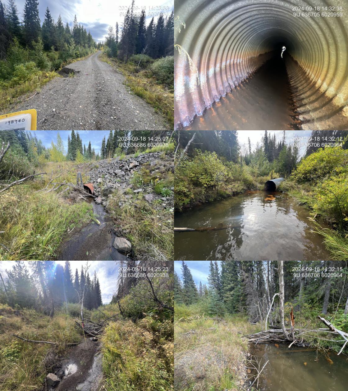
| Date | 2024-09-18 | Crossing Sub Type | Round Culvert |
| PSCIS ID | 198940 | Diameter (m) | 0.95 |
| External ID | – | Length (m) | 25 |
| Crew | AI | Embedded | No |
| UTM Zone | 9 | Depth Embedded (m) | – |
| Easting | 636706 | Resemble Channel | No |
| Northing | 6020960 | Backwatered | Yes |
| Stream | Tributary to Knapper Creek | Percent Backwatered | 30 |
| Road | HM7504 | Fill Depth (m) | 1.75 |
| Road Tenure | Canfor R07549 16 | Outlet Drop (m) | 0 |
| Channel Width (m) | 4.3 | Outlet Pool Depth (m) | 0.9 |
| Stream Slope (%) | 3 | Inlet Drop | Yes |
| Beaver Activity | Yes | Slope (%) | 2 |
| Habitat Value | Medium | Valley Fill | Deep Fill |
| Final score | 24 | Barrier Result | Barrier |
| Fix type | Replace with New Open Bottom Structure | Fix Span / Diameter | 15 |
| Comments: Very nice stream with good flow, abundant gravels for spawning, and undercut banks and occasional deep pools for rearing.The culvert is significantly undersized for the stream, and the road appears to be failing, likely due to a partially clogged inlet and spring freshet. Habitat confirmations were completed for this crossing and the next upstream crossing (198935) on the Gold FSR. Electrofishing above Gold FSR captured rainbow trout, cutthroat trout, and cutthroat trout/rainbow trout hybrids. | |||
| Photos: From top left clockwise: Road/Site Card, Barrel, Outlet, Downstream, Upstream, Inlet. | |||
|
| Location and Stream Data |
|
Crossing Characteristics | – |
|---|---|---|---|
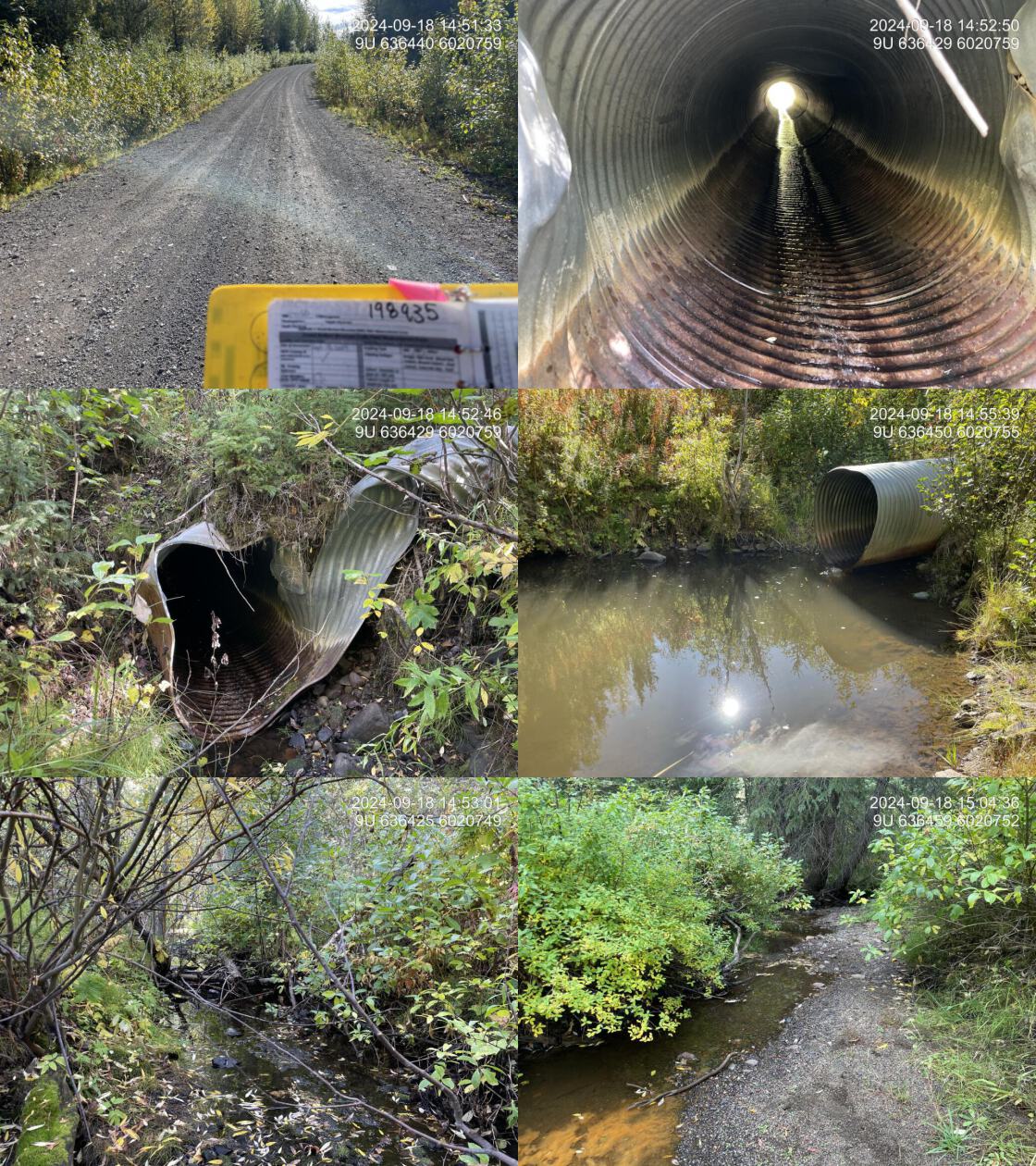
| Date | 2024-09-18 | Crossing Sub Type | Round Culvert |
| PSCIS ID | 198935 | Diameter (m) | 1.2 |
| External ID | – | Length (m) | 20 |
| Crew | LS | Embedded | No |
| UTM Zone | 9 | Depth Embedded (m) | – |
| Easting | 636440 | Resemble Channel | No |
| Northing | 6020756 | Backwatered | No |
| Stream | Tributary to Knapper Creek | Percent Backwatered | – |
| Road | Gold Creek FSR | Fill Depth (m) | 4 |
| Road Tenure | Canfor R07549 6 | Outlet Drop (m) | 0.15 |
| Channel Width (m) | 2.7 | Outlet Pool Depth (m) | 0.8 |
| Stream Slope (%) | 2.2 | Inlet Drop | No |
| Beaver Activity | Yes | Slope (%) | 1.5 |
| Habitat Value | Medium | Valley Fill | Deep Fill |
| Final score | 29 | Barrier Result | Barrier |
| Fix type | Replace with New Open Bottom Structure | Fix Span / Diameter | 18 |
| Comments: The culvert is deteriorating at the inlet. Large outlet pool where fish were captured during sampling. The stream flows from the outlet pool along the left-hand side into a well-defined channel with gravels suitable for spawning and several pools, providing good habitat. A moderate amount of road fill is present. Electrofishing above Gold FSR captured rainbow trout, cutthroat trout, and cutthroat trout/rainbow trout hybrids. | |||
| Photos: From top left clockwise: Road/Site Card, Barrel, Outlet, Downstream, Upstream, Inlet. | |||
|
Stream Characteristics Downstream of Crossing 198940
The stream was surveyed downstream from crossing 198940 for 300m (Figure 5.17).. The habitat was rated as medium, with good flow, abundant gravels, overhanging banks, and healthy riparian vegetation, providing good rearing and spawning habitat for coho, rainbow trout, Dolly Varden, and cutthroat trout. The average channel width was 3.3m, the average wetted width was 1.5m, and the average gradient was 3.3%.Total cover amount was rated as moderate with undercut banks dominant. Cover was also present as small woody debris, large woody debris, and overhanging vegetation.The dominant substrate was gravels with cobbles sub-dominant..
Stream Characteristics Upstream of Crossing 198940 and Downstream of Crossing 198935
The stream was surveyed in the downstream direction, starting at the upstream crossing on Gold Creek FSR (198935), down to the crossing on road/spur HM7504 (198940), a distance of approximately 340 m (Figure 5.18). The dominant substrate was gravels with fines sub-dominant.Total cover amount was rated as moderate with undercut banks dominant. Cover was also present as small woody debris, large woody debris, deep pools, and overhanging vegetation.The average channel width was 2.8m, the average wetted width was 1.2m, and the average gradient was 2.7%. The habitat was rated as medium value with good flow, abundant spawning gravels, and suitable rearing habitat in undercut banks and occasional deep pools. Historic beaver activity was evident, including a large breached dam near the upstream end of the site. The riparian zone consisted of a healthy shrub and herbaceous flood-tolerant plant community. The stream corridor, approximately 40–50 m wide, was bordered by mature coniferous forest on both sides.
Stream Characteristics Upstream of Crossing 198935
The stream was surveyed upstream from crossing 198935 for 700m . (Figure 5.19). The habitat was rated as medium value with a good flow and abundant gravels throughout. A mature mixed forest, including cottonwood, provided excellent bank stabilization, resulting in deeply undercut banks and intermittent pools up to 60 cm deep within the surveyed area. Total cover amount was rated as moderate with undercut banks dominant. Cover was also present as small woody debris, large woody debris, deep pools, and overhanging vegetation.The average channel width was 2.5m, the average wetted width was 1.9m, and the average gradient was 2.2%.The dominant substrate was gravels with fines sub-dominant.
Fish Sampling
Electrofishing was conducted upstream and downstream of crossing (198935) with results summarised in Tables 5.15 - 5.16 and Figure 5.16. A total of 39 fish were captured downstream including rainbow trout, cutthroat trout, and Dolly Varden. Upstream of the crossing 43 fish were captured including rainbow trout, cutthroat trout, and cutthroat trout/rainbow trout hybrid (Figure 5.20). .
Structure Remediation and Cost Estimate
Should restoration/maintenance activities proceed, replacement of the Gold Creek FSR crossing (198935) with a bridge (18 m span) is recommended. At the time of reporting in 2025, the cost of the work is estimated at $ 450,000.
At the time of assessment, the downstream crossing on road/spur HM7504 was unlikely a barrier to fish passage, and restoration efforts should prioritize the upstream crossing on Gold Creek FSR. However, should restoration activities proceed at crossing 198940, replacement with a bridge spanning 15 m is recommended. At the time of reporting in 2025, the estimated cost for the replacement is $ 540,000.
Conclusion
Tributary to Knapper Creek contains moderate-value rearing and spawning habitat for coho, rainbow trout, Dolly Varden, and cutthroat trout. Electrofishing at the time of assessment confirmed the presence of rainbow trout, cutthroat trout, cutthroat/rainbow trout hybrids, and Dolly Varden. Habitat modelling identified 1.2km of steelhead rearing habitat upstream of crossing 198940, with approximately 300m less upstream of 198935. There is suspected interconnection between wetlands in this watershed and adjacent watersheds, suggesting the current modelling may under-represent the watershed’s size.
Should restoration activities proceed, efforts should focus on PSCIS crossingr as.character(my_site2) on Gold Creek FSR, which had a small outlet drop and a deep outlet pool. PSCIS crossing 198940 on Road/Spur HM7504 was backwatered and not presumed to be a barrier to fish passage. Both crossings were noted as undersized for the stream.
tab_hab_summary |>
  dplyr::filter(Site %in% c(my_site, my_site2)) |>
  fpr::fpr_kable(caption_text = paste0("Summary of habitat details for PSCIS crossings ", my_site, " and ", my_site2, "."),
scroll = F) | Site | Location | Length Surveyed (m) | Average Channel Width (m) | Average Wetted Width (m) | Average Pool Depth (m) | Average Gradient (%) | Total Cover | Habitat Value |
|---|---|---|---|---|---|---|---|---|
| 198935 | Upstream | 700 | 2.5 | 1.9 | 0.4 | 2.2 | moderate | medium |
| 198940 | Downstream | 300 | 3.3 | 1.5 | 0.4 | 3.3 | moderate | medium |
| 198940 | Upstream | 340 | 2.8 | 1.2 | 0.3 | 2.7 | moderate | medium |
| site | passes | ef_length_m | ef_width_m | area_m2 | enclosure |
|---|---|---|---|---|---|
| 198935_ds_ef1 | 1 | 8 | 1.1 | 8.8 | partial enclosure |
| 198935_us_ef1 | 1 | 30 | 1.6 | 48.0 | partial enclosure |
| local_name | species_code | life_stage | catch | density_100m2 | nfc_pass |
|---|---|---|---|---|---|
| 198935_ds_ef1 | Cutthroat Trout | adult | 1 | 11.4 | FALSE |
| 198935_ds_ef1 | Cutthroat Trout | parr | 4 | 45.5 | FALSE |
| 198935_ds_ef1 | Dolly Varden | parr | 1 | 11.4 | FALSE |
| 198935_ds_ef1 | Rainbow Trout | fry | 12 | 136.4 | FALSE |
| 198935_ds_ef1 | Rainbow Trout | parr | 21 | 238.6 | FALSE |
| 198935_us_ef1 | Cutthroat Trout | adult | 1 | 2.1 | FALSE |
| 198935_us_ef1 | Cutthroat Trout /Rainbow Trout hybrid | fry | 1 | 2.1 | FALSE |
| 198935_us_ef1 | Rainbow Trout | adult | 1 | 2.1 | FALSE |
| 198935_us_ef1 | Rainbow Trout | fry | 23 | 47.9 | FALSE |
| 198935_us_ef1 | Rainbow Trout | juvenile | 1 | 2.1 | FALSE |
| 198935_us_ef1 | Rainbow Trout | parr | 16 | 33.3 | FALSE |
|
* nfc_pass FALSE means fish were captured in final pass indicating more fish of this species/lifestage may have remained in site. Mark-recaptured required to reduce uncertainties. |
my_caption <- paste0('Densites of fish (fish/100m2) captured upstream and downstream of PSCIS crossing ', my_site2, '.')

fpr::fpr_plot_fish_box(sit = my_site2) 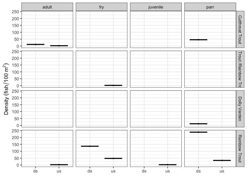
Figure 5.16: Densites of fish (fish/100m2) captured upstream and downstream of PSCIS crossing 198935.
my_photo1 = fpr::fpr_photo_pull_by_str(str_to_pull = 'ds_typical_2_')

my_caption1 = paste0('Typical habitat downstream of PSCIS crossing ', my_site, '.')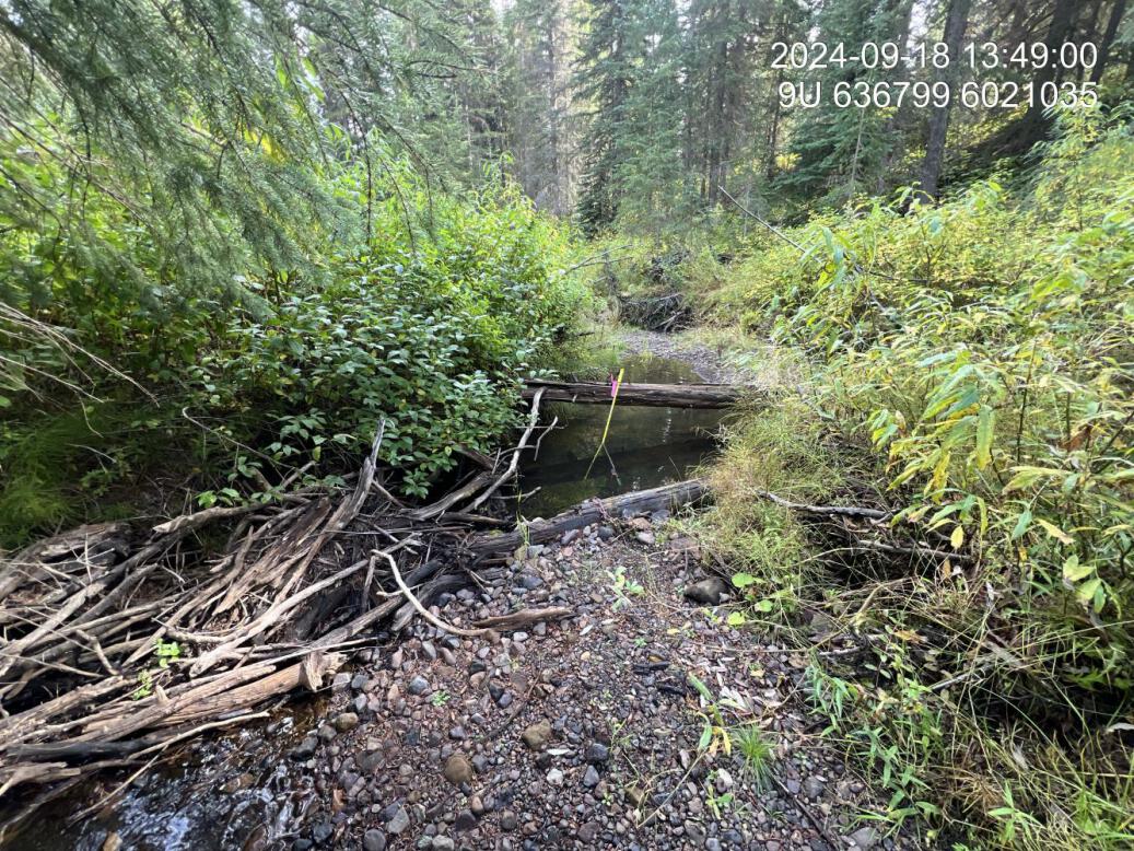
Figure 5.17: Typical habitat downstream of PSCIS crossing 198940.
my_photo2 = fpr::fpr_photo_pull_by_str(str_to_pull = 'us_typical_1')

my_caption2 = paste0('Typical habitat upstream of PSCIS crossing ', my_site, '.')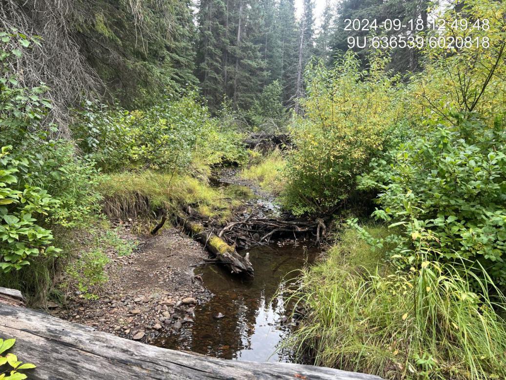
Figure 5.18: Typical habitat upstream of PSCIS crossing 198940.
my_caption <- paste0('Left: ', my_caption1, ' Right: ', my_caption2)

knitr::include_graphics(my_photo1)
knitr::include_graphics("fig/pixel.png")
knitr::include_graphics(my_photo2)
my_photo1 = fpr::fpr_photo_pull_by_str(site = my_site2, str_to_pull = 'us_typical_2')
my_caption1 = paste0('Typical habitat upstream of PSCIS crossing ', my_site2, '.')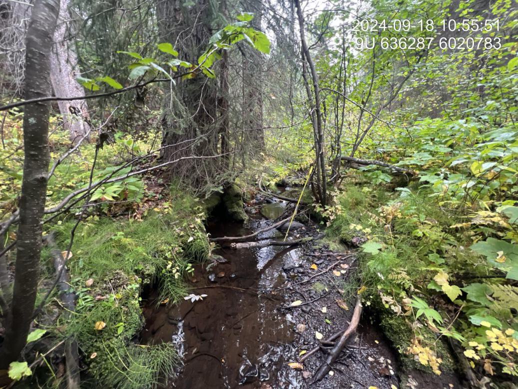
Figure 5.19: Typical habitat upstream of PSCIS crossing 198935.
my_photo2 = fpr::fpr_photo_pull_by_str(site = my_site2, str_to_pull = 'fish_1')

my_caption2 = paste0('Rainbow trout captured downstream of crossing ', my_site2, '.')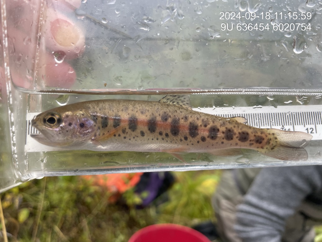
Figure 5.20: Rainbow trout captured downstream of crossing 198935.
my_caption <- paste0('Left: ', my_caption1, ' Right: ', my_caption2)

knitr::include_graphics(my_photo1)
knitr::include_graphics("fig/pixel.png")
knitr::include_graphics(my_photo2)