Tributary to Kerry Lake - 198692 - Appendix
Site Location
PSCIS crossings 198692 is located on Tributary To Kerry Lake, at kilometer 7 of Kerry Lake FSR, approximately 25km north of the community of Bear Lake, BC (Figure 5.11). The crossing is located 750m upstream of the streams confluence with Kerry Lake, on the northwestern side of the lake. Located. At this location, the road is the responsibility of the Ministry of Forests. The crossing is within the Crooked River watershed group.
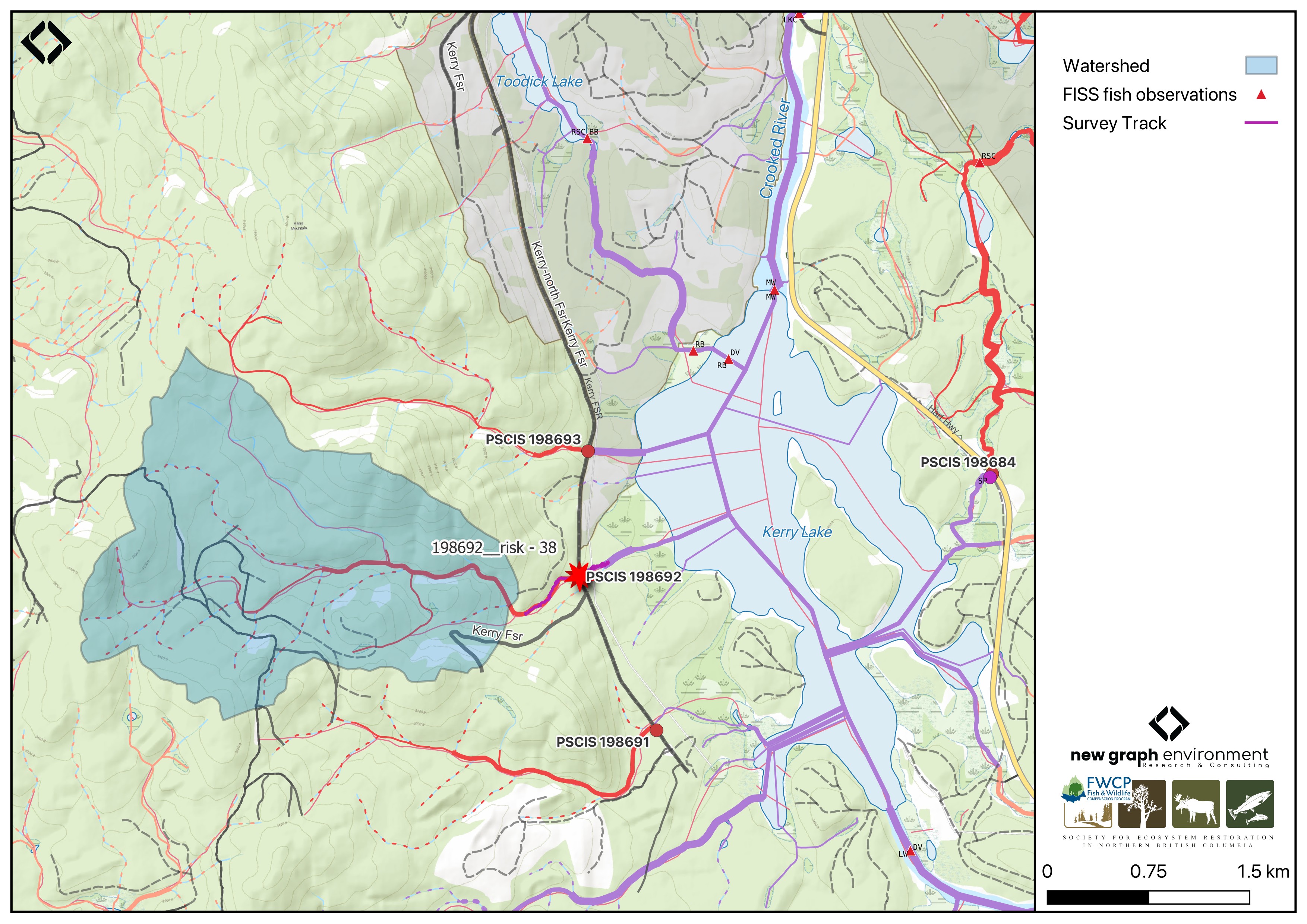
Figure 5.11: Map of Tributary to Kerry Lake
Background
At this location, Tributary To Kerry Lake is a third order stream and drains a watershed of approximately 5.1km2. The watershed ranges in elevation from a maximum of 1148m to 725m near the crossing (Table 5.11).
In 2023, crossing 198692 was assessed with a fish passage assessment and prioritized for follow-up with a habitat confirmation assessment due to the presence of quality habitat observed upstream and its proximity to fish-bearing Kerry Lake (Irvine and Winterscheidt 2024). No fisheries data are available for this stream; however, longnose sucker, lake chub, peamouth chub, northern pikeminnow, longnose dace, redside shiner, rainbow trout, mountain whitefish, dolly varden, and prickly sculpin have been documented in Kerry Lake, located just downstream, in BC Fisheries Information Summary System (FISS) (Norris [2018] 2024; MoE 2024). Although Dolly Varden are documented in the Crooked River watershed group, these records are likely misidentifications of bull trout (Comittee on the Status of Endangered Wildlife in Canada 2012).
fpr::fpr_table_wshd_sum(site_id = my_site) |>
  fpr::fpr_kable(caption_text = paste0('Summary of derived upstream watershed statistics for PSCIS crossing ', my_site, '.'),
           footnote_text = 'Elev P60 = Elevation at which 60% of the watershed area is above',
scroll = F)| Site | Area Km | Elev Site | Elev Min | Elev Max | Elev Median | Elev P60 | Aspect |
|---|---|---|---|---|---|---|---|
| 198692 | 5.1 | 725 | 760 | 1148 | 973 | 955 | SE |
| * Elev P60 = Elevation at which 60% of the watershed area is above |
A summary of habitat modelling outputs for the crossing are presented in Table 5.12. A map of the watershed is provided in map attachment 093J.118.
| Habitat | Potential | Remediation Gain | Remediation Gain (%) |
|---|---|---|---|
| BT Rearing (km) | 2.3 | 2.3 | 100 |
| BT Spawning (km) | 0.0 | 0.0 | – |
| BT Network (km) | 12.4 | 6.8 | 55 |
| BT Stream (km) | 12.2 | 6.7 | 55 |
| BT Lake Reservoir (ha) | 0.0 | 0.0 | – |
| BT Wetland (ha) | 1.1 | 0.5 | 45 |
| BT Slopeclass03 (km) | 0.8 | 0.1 | 12 |
| BT Slopeclass05 (km) | 0.0 | 0.0 | – |
| BT Slopeclass08 (km) | 4.1 | 2.1 | 51 |
| BT Slopeclass15 (km) | 4.4 | 3.5 | 80 |
| * Model data is preliminary and subject to adjustments. |
Stream Characteristics at Crossing 198692
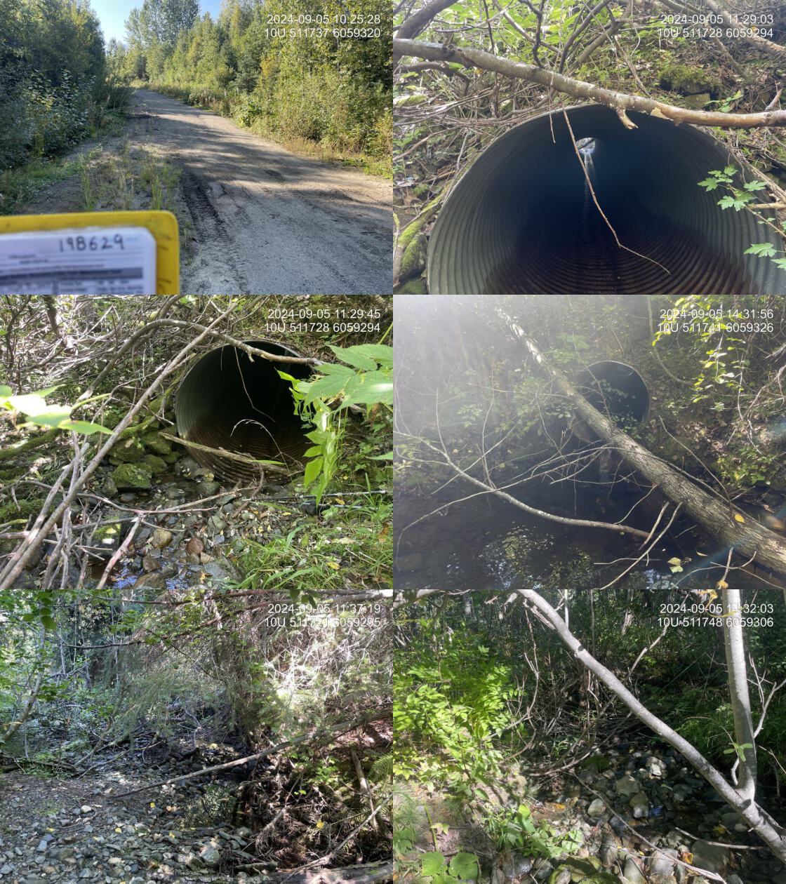
At the time of the 2024 assessment, the crossing on Kerry Lake FSR was un-embedded, non-backwatered and ranked as a barrier to upstream fish passage according to the provincial protocols (MoE 2011) (Table 5.13). The culvert had a 0.34m outlet drop and a 0.8m deep outlet pool.
The water temperature was 7.4\(^\circ\)C, pH was 8.2 and conductivity was 99 uS/cm.
| Location and Stream Data |
|
Crossing Characteristics | – |
|---|---|---|---|
| Date | 2024-09-05 | Crossing Sub Type | Round Culvert |
| PSCIS ID | 198692 | Diameter (m) | 1.2 |
| External ID | – | Length (m) | 19 |
| Crew | LS AI | Embedded | No |
| UTM Zone | 10 | Depth Embedded (m) | – |
| Easting | 511736 | Resemble Channel | No |
| Northing | 6059308 | Backwatered | No |
| Stream | Tributary To Kerry Lake | Percent Backwatered | – |
| Road | Kerry Lake FSR | Fill Depth (m) | 2.5 |
| Road Tenure | MoF | Outlet Drop (m) | 0.34 |
| Channel Width (m) | 4 | Outlet Pool Depth (m) | 0.82 |
| Stream Slope (%) | 5 | Inlet Drop | No |
| Beaver Activity | Yes | Slope (%) | 4 |
| Habitat Value | Medium | Valley Fill | Deep Fill |
| Final score | 39 | Barrier Result | Barrier |
| Fix type | Replace with New Open Bottom Structure | Fix Span / Diameter | 15 |
| Comments: Rainbow trout juveniles and adults (40-120mm in fork length) were captured with electrofishing within sites located 50m upstream and downstream of the Kerry Lake FSR. Fish were also observed in the outlet pool and upstream of the FSR crossing. There was beaver activity near the inlet and a large outlet drop. Upstream gravels provide suitable spawning habitat for resident fish, with good riparian vegetation supporting overall habitat quality. If there are no plans for further logging in the area, removing the crossing and deactivating the road could be considered as a fish passage remediation option. | |||
| Photos: From top left clockwise: Road/Site Card, Barrel, Outlet, Downstream, Upstream, Inlet. | |||
|
Stream Characteristics Downstream of Crossing 198692
The stream was surveyed downstream from crossing 198692 for 230m . Frequent deep pools provided cover for resident fish and gravels were present for spawning. The habitat was rated as medium value for anandromous spawning and rearing (Figure 5.14). The stream frequently flowed subsurface beginning around 200m downstream of the crossing. Total cover amount was rated as abundant with large woody debris dominant. Cover was also present as small woody debris, undercut banks, deep pools, and overhanging vegetation.The dominant substrate was cobbles with gravels sub-dominant.The average channel width was 3.0m, the average wetted width was 1.4m, and the average gradient was 2.5%.
Stream Characteristics Upstream of Crossing 198692
The stream was surveyed upstream from crossing 198692 for 500m . The stream was noted as having significant flow for the time of year. The habitat was rated as medium value, with patches of gravel suitable for spawning resident rainbow trout and bull trout present (Figure 5.15). The stream narrowed into a canyon approximately 150m upstream of Kerry FSR (Figure 5.16). Total cover amount was rated as abundant with undercut banks dominant. Cover was also present as small woody debris, large woody debris, deep pools, and overhanging vegetation.The dominant substrate was cobbles with gravels sub-dominant.The average channel width was 4m, the average wetted width was 1.5m, and the average gradient was 5%.
Fish Sampling
# species captured downstream
tab_fish_summary |>
  dplyr::filter(site_id == paste0(my_site, '_ds')) |>
  dplyr::group_by(site_id) |>
  dplyr::distinct(species) |>
  dplyr::pull(species)

# species captured upstream
tab_fish_summary |>
  dplyr::filter(site_id == paste0(my_site, '_us')) |>
  dplyr::group_by(site_id) |>
  dplyr::distinct(species) |>
  dplyr::pull(species)
Electrofishing was conducted downstream and upstream of the Kerry Lake FSR crossing with results summarised in Tables 5.15 - 5.16 and Figure 5.13. A total of 70 fish were captured downstream and 20 fish were captured upstream, all of which were rainbow trout (Figure 5.16).
Aerial Imagery
An aerial survey was conducted with a remotely piloted aircraft and the resulting imagery was processed into an orthomosaic available to view and download in Figure 5.12.
viewer_url <- '<iframe src="https://viewer.a11s.one/?cog=https://imagery-uav-bc.s3.amazonaws.com/mackenzie/carp/2024/198692_kerry_lake_trib/odm_orthophoto/odm_orthophoto.tif" scrolling="no" title="UAV Viewer" width="100%" height="600" frameBorder="0"></iframe>'

knitr::asis_output(viewer_url)
my_photo = 'fig/pixel.png'
my_caption = paste0('Orthomosaic of PSCIS crossing ', my_site, '.')
knitr::include_graphics(my_photo, dpi = NA)Figure 5.12: Orthomosaic of PSCIS crossing 198692.
Structure Remediation and Cost Estimate
Should restoration/maintenance activities proceed, replacement of the Kerry Lake FSR crossing with a bridge (15 m span) is recommended. At the time of reporting in 2025, the cost of the work is estimated at $ 450,000.
Conclusion
Approximately 2.3km of bull trout rearing habitat is modelled upstream, and the habitat was rated as medium value for resident salmonid spawning and rearing. The 0.34m outlet drop at PSCIS crossing 198692 likely inhibits juvenile resident salmonid fish passage and the crossing is rated as a high priority for replacement. Although bull trout were not captured at the time of assessment, they have historically been captured downstream in Kerry Lake (mis-identified as dolly varden). The stream was noted as having good flow for time of year and during an uncharacteristically dry/hot spring and summer.
tab_hab_summary |>
  dplyr::filter(Site %in% c(my_site)) |>
  fpr::fpr_kable(caption_text = paste0("Summary of habitat details for PSCIS crossings ", my_site, "."),
scroll = F) | Site | Location | Length Surveyed (m) | Average Channel Width (m) | Average Wetted Width (m) | Average Pool Depth (m) | Average Gradient (%) | Total Cover | Habitat Value |
|---|---|---|---|---|---|---|---|---|
| 198692 | Downstream | 230 | 3 | 1.4 | 0.4 | 2.5 | abundant | medium |
| 198692 | Upstream | 500 | 4 | 1.5 | 0.2 | 5.0 | abundant | medium |
| site | passes | ef_length_m | ef_width_m | area_m2 | enclosure |
|---|---|---|---|---|---|
| 198692_ds_ef1 | 1 | 20 | 1.9 | 38.0 | partial enclosure |
| 198692_ds_ef2 | 1 | 4 | 5.0 | 20.0 | open |
| 198692_us_ef1 | 1 | 27 | 1.4 | 37.8 | partial enclosure |
| local_name | species_code | life_stage | catch | density_100m2 | nfc_pass |
|---|---|---|---|---|---|
| 198692_ds_ef1 | Rainbow Trout | fry | 36 | 94.7 | FALSE |
| 198692_ds_ef2 | Rainbow Trout | adult | 1 | 5.0 | FALSE |
| 198692_ds_ef2 | Rainbow Trout | fry | 1 | 5.0 | FALSE |
| 198692_ds_ef2 | Rainbow Trout | juvenile | 5 | 25.0 | FALSE |
| 198692_ds_ef2 | Rainbow Trout | parr | 27 | 135.0 | FALSE |
| 198692_us_ef1 | Rainbow Trout | fry | 10 | 26.5 | FALSE |
| 198692_us_ef1 | Rainbow Trout | parr | 10 | 26.5 | FALSE |
|
* nfc_pass FALSE means fish were captured in final pass indicating more fish of this species/lifestage may have remained in site. Mark-recaptured required to reduce uncertainties. |
my_caption <- paste0('Densites of fish (fish/100m2) captured upstream and downstream of PSCIS crossing ', my_site, '.')

fpr::fpr_plot_fish_box() 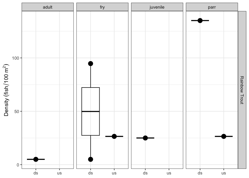
Figure 5.13: Densites of fish (fish/100m2) captured upstream and downstream of PSCIS crossing 198692.
my_photo1 = fpr::fpr_photo_pull_by_str(str_to_pull = 'ds_typical_1_')

my_caption1 = paste0('Typical habitat downstream of PSCIS crossing ', my_site, '.')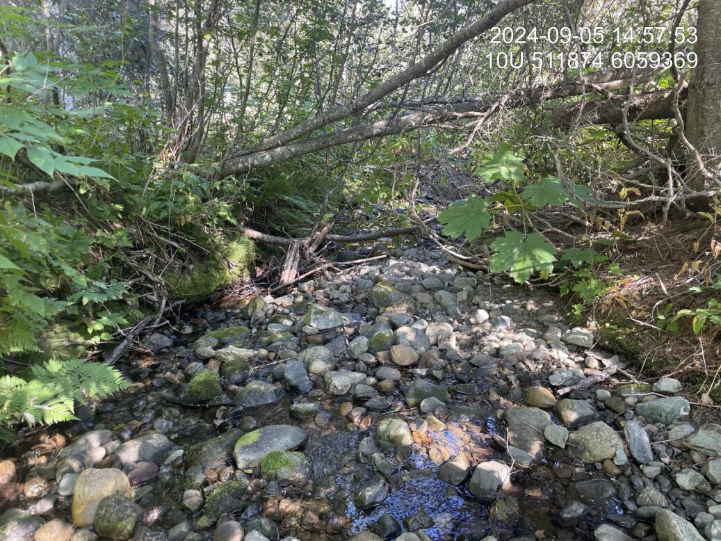
Figure 5.14: Typical habitat downstream of PSCIS crossing 198692.
my_photo2 = fpr::fpr_photo_pull_by_str(str_to_pull = 'us_typical_1')

my_caption2 = paste0('Typical habitat upstream of PSCIS crossing ', my_site, '.')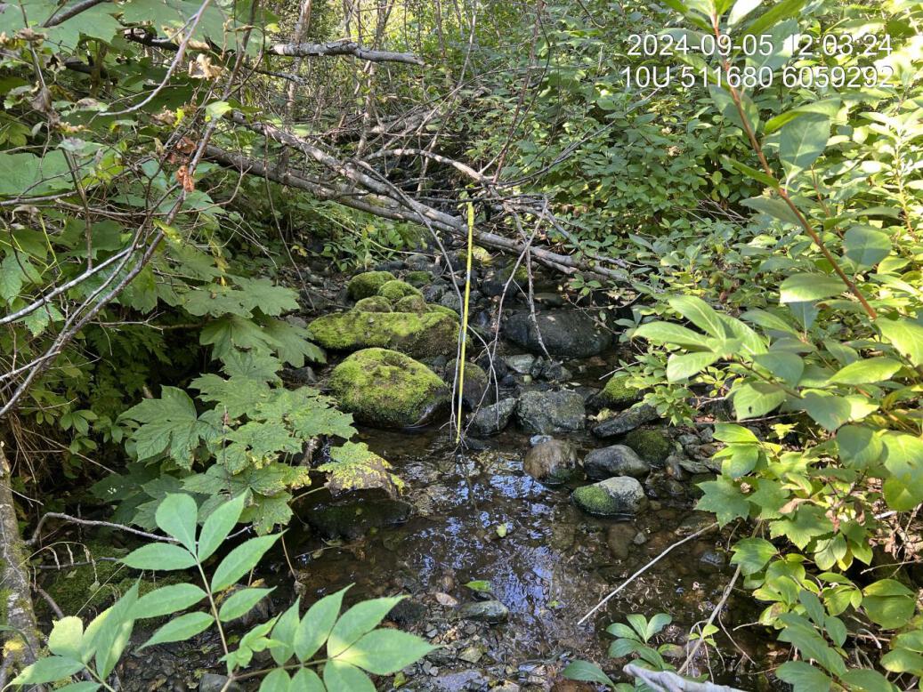
Figure 5.15: Typical habitat upstream of PSCIS crossing 198692.
my_caption <- paste0('Left: ', my_caption1, ' Right: ', my_caption2)

knitr::include_graphics(my_photo1)
knitr::include_graphics("fig/pixel.png")
knitr::include_graphics(my_photo2)
my_photo1 = fpr::fpr_photo_pull_by_str(str_to_pull = 'us_typical_2_')
my_caption1 = paste0('Canyon located approximately 150m upstream of PSCIS crossing ', my_site, '.')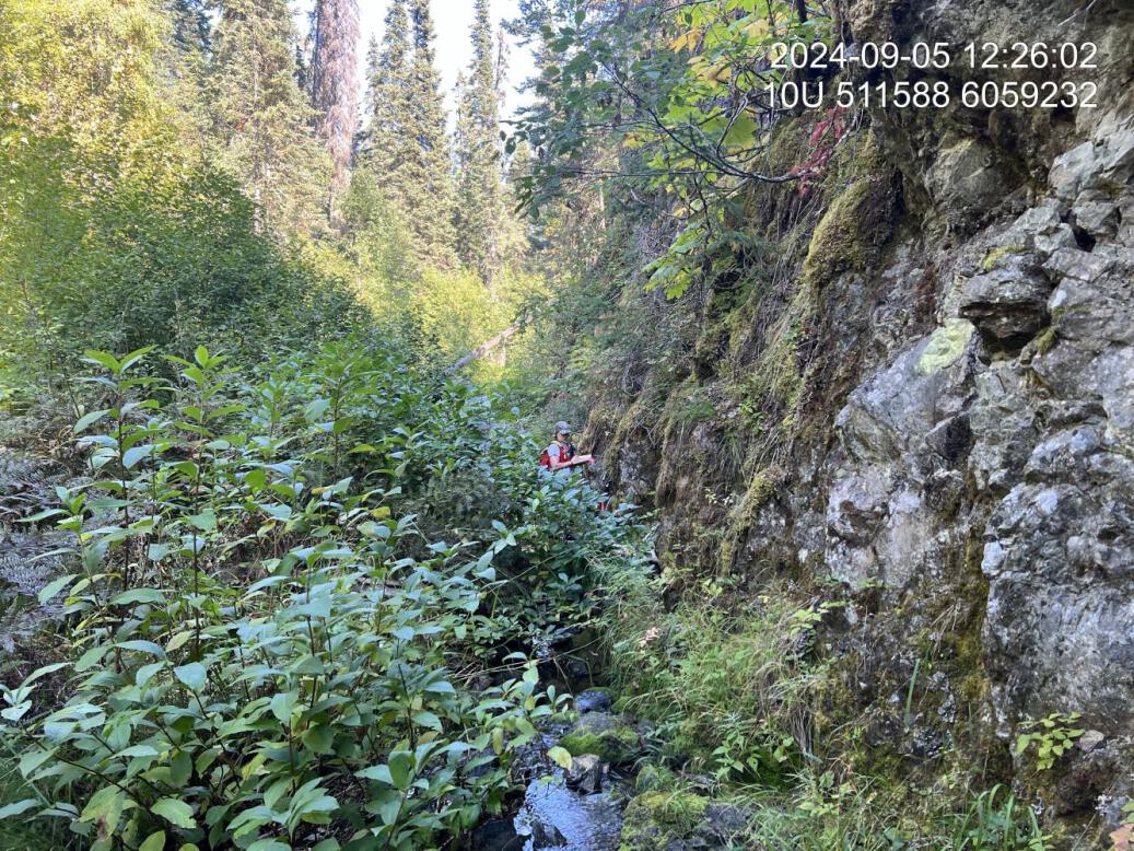
Figure 5.16: Canyon located approximately 150m upstream of PSCIS crossing 198692.
my_photo2 = fpr::fpr_photo_pull_by_str(str_to_pull = 'fish1')

my_caption2 = paste0('Rainbow trout captured upstream of PSCIS crossing ', my_site, '.')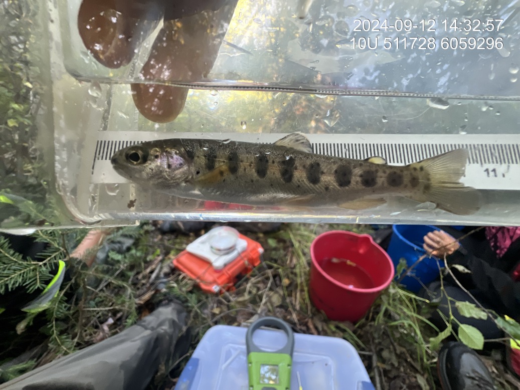
Figure 5.17: Rainbow trout captured upstream of PSCIS crossing 198692.