Appendix - 197534 - Weigert Creek
Site Location
Crossing 197534 is located on a Weigert Creek, approximately 675m upstream from the confluence with the Elk River. The crossing is located on Highway 43 approximately 20km north of Sparwood. Elk Valley Park recreation site is located downstream of the crossing adjacent to the right bank of the river and the watershed upstream of the crossing is a habitat protection area with motor vehicle restrictions.
Background
At the crossing location, the stream is fourth order with a watershed area upstream of the road of approximately 43.3 km2 situated between Phillips Peak and Mount VanBuskirk. The elevation of the watershed ranges from a maximum of 2950 to 1250m at the culvert. Although, there are several modelled crossings on the mainstem of Hartley Creek upstream of the crossing, 2020 surveys indicated they were either fords or bridges. Modelled crossing 4606006 is a ford located approximately 1.2km upstream of the highway. There are several additional crossings modelled further upstream on the mainstem, however it is suspected that these crossings have been removed to facilitate the motor vehicle restrictions in place in the watershed. Westslope cutthroat trout and bull trout have been recorded in Weigert Creek downstream of PCSIS 197534. Although multiple upstream survey sites are recorded within provincial databases, there have been no fish recorded upstream (MoE 2020d, 2020b).
PSCIS stream crossing 197534 was ranked as a high priority for follow up with habitat confirmation due to the large amount of potential habitat modelled upstream (20km). The habitat confirmation was completed on September 17, 2020. A map of the watershed including areas surveyed is provided in Attachment 1 – Map 082G.123.
Stream Characteristics at Crossing
At the time of the survey, the un-embedded and non-backwatered 3.2m diameter crossing was considered a barrier to upstream fish passage with a pipe length of 18m, a culvert slope of 3.4%, a stream width ratio of 1.3 and an outlet drop of 0.15m (Table 5.30). Water temperature was 3\(^\circ\)C, pH was 8.5 and conductivity was 422uS/cm.
Stream Characteristics Downstream
The stream was surveyed downstream from the culvert for 675m. Overall total cover amount was rated as moderate with undercut banks dominant. Cover was also present as small woody debris, large woody debris, boulders, deep pools, and overhanging vegetation (Table 5.31, Figure 5.33). The average channel width was 4.7m, the average wetted width was 3.6m and the average gradient was 3.7%. The dominant substrate was cobbles with gravels subdominant. Pools were present to 0.8m deep and gravels/cobbles suitable for resident and fluvial spawning were present. A ford crosses the stream at the Fortis gasline located approximately 115m downstream of the highway. Overall, habitat was rated as medium value providing an important migration corridor and habitat suitable for resident and fluvial salmonid rearing and spawning.
Stream Characteristics Upstream
The stream was surveyed immediately upstream from the culvert for 675m. Overall, total cover amount was rated as moderate with undercut banks dominant. Cover was also present as small woody debris, large woody debris, boulders, deep pools, and overhanging vegetation (Table 5.31, Figure 5.34). The average channel width was 6.6m, the average wetted width was 4.6m and the average gradient was 4.5%. The dominant substrate was cobbles with boulders subdominant. Habitat became increasingly complex with increased distance upstream. Throughout the area surveyed there were occasional pools available with depths suitable for juvenile/adult salmonid overwintering and rearing and frequent sections of gravels available for resident and fluvial salmonid spawning. Overall, habitat was rated as medium value.
Structure Remediation and Cost Estimate
Structure replacement with a bridge is recommended to provide access to the habitat located upstream of PSCIS crossing 197534. The cost of the work is estimated at $5,000,000 for a cost benefit of 2.3 linear m/$1000 and 15.3m2/$1000.
Conclusion
There is an estimated 11.6km of mainstem Weigert Creek habitat available upstream of PSCIS 197534 with habitat in areas surveyed rated as high value, representing an important migration corridor with high rearing and spawning potential for resident and fluvial salmonids. Highway 43 is the responsibility of the Ministry of Transportation and Infrastructure. The crossing was ranked as a high priority for proceeding to design for replacement with an open bottomed structure.
| Location and Stream Data |
|
Crossing Characteristics | – |
|---|---|---|---|
| Date | 2020-09-17 | Crossing Sub Type | Round Culvert |
| PSCIS ID | 197534 | Diameter (m) | 3.2 |
| External ID | – | Length (m) | 18 |
| Crew | AI, KP | Embedded | No |
| UTM Zone | 11 | Depth Embedded (m) | – |
| Easting | 650144 | Resemble Channel | No |
| Northing | 5532055 | Backwatered | No |
| Stream | Weigert Creek | Percent Backwatered | – |
| Road | Highway 43 | Fill Depth (m) | 1.3 |
| Road Tenure | MoTi highway | Outlet Drop (m) | 0.15 |
| Channel Width (m) | 4.3 | Outlet Pool Depth (m) | 0.6 |
| Stream Slope (%) | 2 | Inlet Drop | Yes |
| Beaver Activity | No | Slope (%) | 3.4 |
| Habitat Value | High | Valley Fill | Deep Fill |
Photos: From top left clockwise: Road/Site Card, Barrel, Outlet, Downstream, Upstream, Inlet.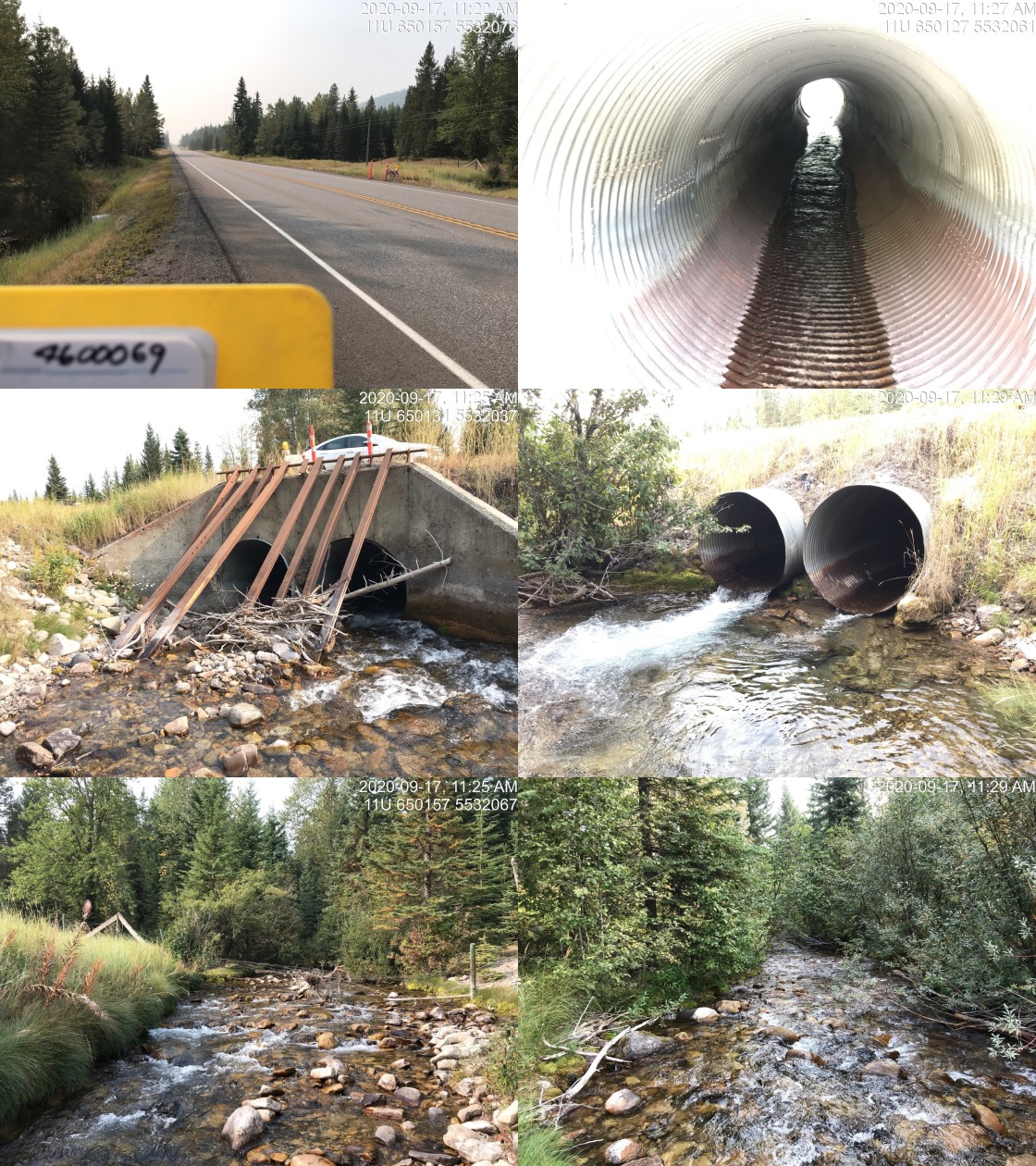
|
| Location | Length Surveyed (m) | Channel Width (m) | Wetted Width (m) | Pool Depth (m) | Gradient (%) | Total Cover | Habitat Value |
|---|---|---|---|---|---|---|---|
| Upstream | 1100 | 6.6 | 4.6 | 0.5 | 4.5 | moderate | high |
| Downstream | 675 | 4.7 | 3.6 | 0.5 | 3.7 | moderate | medium |
Figure 5.33: Habitat downstream of PSCIS crossing 197534.
Figure 5.34: Habitat upstream of PSCIS crossing 197534.