Appendix - 50155 - Tributary to Lizard Creek
Site Location
Crossing 50155 is located on a tributary to Lizard Creek, approximately 75m upstream from the confluence with Lizard Creek. The stream is located approximately 100m east of the location where it is mapped on the freshwater atlas stream layer. The culvert is located at km 3.6 of Island Lake Lodge Road which is an extension of Mt.Fernie Park Road with access from Highway 3 located within Fernie city limits. The area is a popular recreational destination for hikers and mountain bikers. Island Lake Lodge is a year round tourist destination in the Lizard Creek watershed providing accommodations, guided hiking and backcountry catskiing for clients.
Background
At the crossing location, the stream is 2nd order with a watershed area upstream of the road of approximately 1.8km2. The elevation of the watershed ranges from a maximum of 1945m to 1080m at the culvert. One 12m long bridge (PSCIS 197543) is located upstream of the subject crossing approximately 575m on the Lazy Lizard bike trail and another 7m long bridge structure is located downstream also on a recreational trail. A search of provincial records yielded no fisheries information for the stream (MoE 2020d). Downstream, Lizard Creek supports westslope cutthroat trout, bull trout, mountain whitefish, brook trout, longnose sucker and longnose dace (MoE 2020b). Elk River Alliance (2020) conducted redd surveys in Lizard Creek in 2019 along with Morrissey Creek, Coal Creek and Forsyth Creek. A total of 55 redds were observed within a 2.4km section of Lizard Creek comprising the largest densities of redds of the four tributaries surveyed (22.9 redds/km).
PSCIS stream crossing 50155 was ranked as a high priority for follow up with habitat confirmation due to the large size of the stream relative to other tributary streams in the watershed, the previously rated high value habitat and because it was prioritized for follow up by VAST Resource Solutions Inc. (2013). The habitat confirmation was completed on September 22, 2020. A map of the watershed including areas surveyed is provided in Attachment 1 – Map 082G.113.
Stream Characteristics at Crossing
At the time of the survey, the un-embedded and non-backwatered 0.9m diameter crossing was considered a barrier to upstream fish passage with a pipe length of 11m, a culvert slope of 2.6%, a stream width ratio of 2.5 an outlet drop of 0.22m (Table 5.3). Water temperature was 9\(^\circ\)C, pH was 7.7 and conductivity was 480uS/cm.
Stream Characteristics Downstream
The stream was surveyed downstream from the culvert for 100m to Lizard Creek. Overall, total cover amount was rated as moderate with undercut banks dominant. Cover was also present as small woody debris, large woody debris, and overhanging vegetation (Table 5.8, Figure 5.4). The average channel width was 2.2m, the average wetted width was 1.9m and the average gradient was 4.3%. Habitat value was rated as medium with good potential for fry/juvenile salmonid rearing but a lack of deep pools for adult overwintering and rearing.
Stream Characteristics Upstream
The stream was surveyed upstream from the culvert for 700m. Overall, total cover amount was rated as abundant with deep pools dominant. Cover was also present as small woody debris, large woody debris, boulders, undercut banks, and overhanging vegetation (Table 5.8, Figure 5.5). The average channel width was 2.2m, the average wetted width was 1.6m and the average gradient was 10.5%. Frequent areas of gravels suitable for resident westslope cutthrout trout spawning and pools to 40cm deep associated with small and large woody debris were present throughout areas surveyed. Habitat value was rated as high for fry and juvenile westslope cutthrout rearing.
Fish Sampling
To assess potential impacts of the culvert on fish densities in the stream we electrofished upstream and downstream of the crossing. Three sites were sampled upstream and one site was sampled downstream. A total of 42 westslope cutthrout trout and 4 eastern brook trout were captured upstream with 28 westslope cutthrout trout and 2 eastern brook trout captured downstream. Raw results are included in digital format as Attachment 2 and summarized in Tables 5.5 - 5.6 and Figure 5.3.
Structure Remediation and Cost Estimate
Structure replacement with a bridge is recommended to provide unconstained access to the habitat located upstream of PSCIS crossing 50155. The cost of the work is estimated at $125,000 for a cost benefit of 14.4 linear m/$1000 and 31.7m2/$1000.
Conclusion
There is an estimated 1.8km of mainstem habitat upstream of crossing 50155 with habitat in the areas surveyed rated as high value for fry and juvenile salmonid rearing. Although potentially attributable to lower gradient habitat and closer proximity to the Lizard Creek mainstem, fish sampling results demonstrated that westslope cutthrout trout fry densities were lower upstream of the crossing than below. The road may be permitted to Island Lake Lodge or solely the responsibility of the Ministry of Forests, Lands, Natural Resource Operations & Rural Development. The crossing was ranked as a moderate priority for proceeding to design for replacement with an open bottomed structure.
| Location and Stream Data |
|
Crossing Characteristics | – |
|---|---|---|---|
| Date | 2020-09-22 | Crossing Sub Type | Round Culvert |
| PSCIS ID | 50155 | Diameter (m) | 0.9 |
| External ID | – | Length (m) | 11 |
| Crew | KP, AI | Embedded | No |
| UTM Zone | 11 | Depth Embedded (m) | – |
| Easting | 635113 | Resemble Channel | No |
| Northing | 5484261 | Backwatered | No |
| Stream | Tributary to Lizard Creek | Percent Backwatered | – |
| Road | Island Lake Lodge Road | Fill Depth (m) | 0.3 |
| Road Tenure | MoTi recreation | Outlet Drop (m) | 0.22 |
| Channel Width (m) | 2.25 | Outlet Pool Depth (m) | 0.45 |
| Stream Slope (%) | 4.3 | Inlet Drop | Yes |
| Beaver Activity | No | Slope (%) | 2.6 |
| Habitat Value | Medium | Valley Fill | Deep Fill |
Photos: From top left clockwise: Road/Site Card, Barrel, Outlet, Downstream, Upstream, Inlet.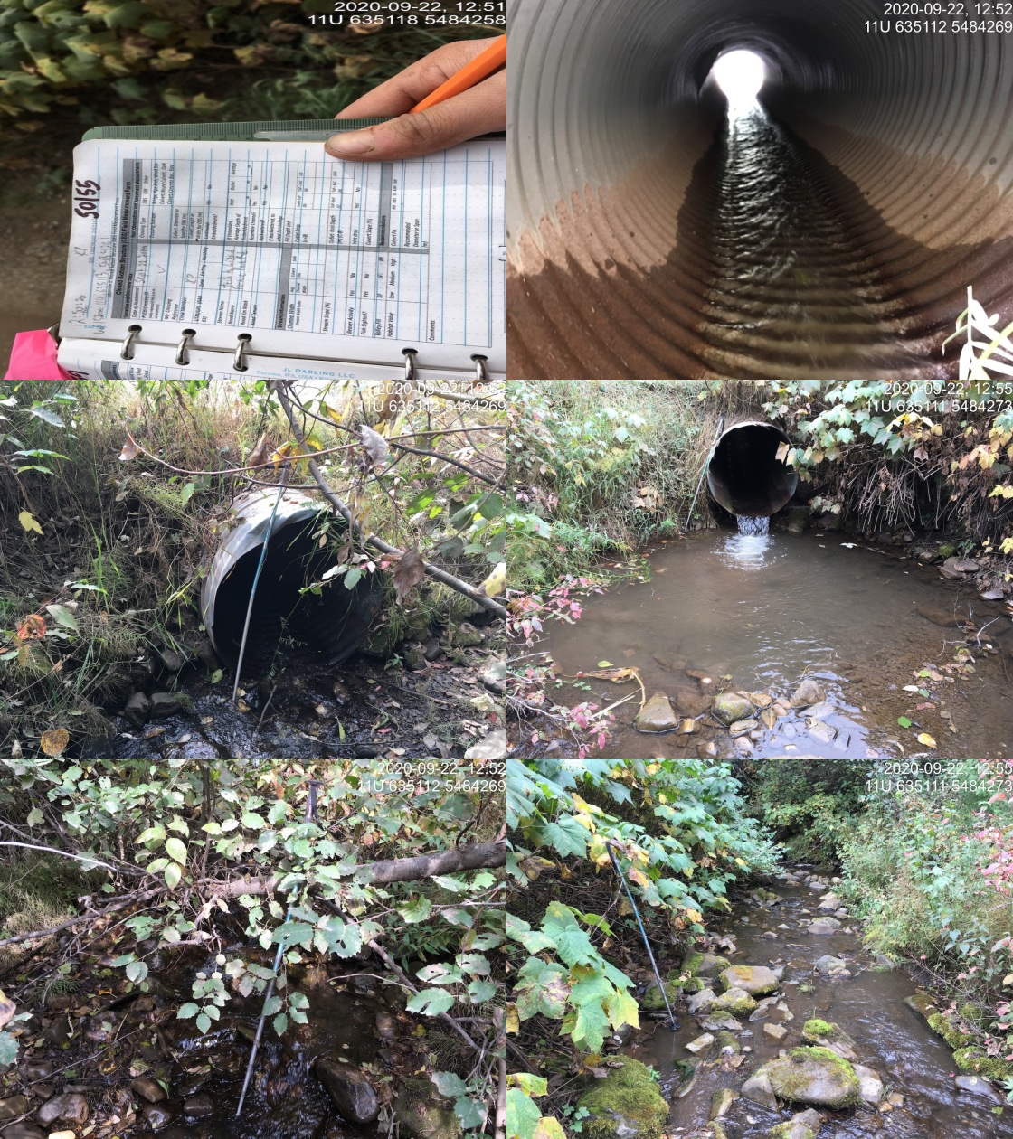
|
| Location | Length Surveyed (m) | Channel Width (m) | Wetted Width (m) | Pool Depth (m) | Gradient (%) | Total Cover | Habitat Value |
|---|---|---|---|---|---|---|---|
| Upstream | 700 | 2.2 | 1.6 | 0.3 | 10.5 | abundant | high |
| Downstream | 100 | 2.2 | 1.9 | – | 4.3 | moderate | medium |
| Site | Location | Width (m) | Length (m) | Area (m2) | Effort (s) | Effort (s/m2) |
|---|---|---|---|---|---|---|
| 19 | Downstream | 1.7 | 40 | 68 | 200 | 2.9 |
| 18 | Upstream | 1.6 | 25 | 40 | 117 | 2.9 |
| 33 | Upstream | 1.6 | 13 | 21 | 61 | 2.9 |
| 34 | Upstream | 1.6 | 45 | 72 | 154 | 2.1 |
| Site | Location | Fry | Parr | Adult | Juvenile |
|---|---|---|---|---|---|
| 19 | Downstream | 35.3 | 4.4 | 1.5 | 0 |
| 18 | Upstream | 15 | 12.5 | 0 | 0 |
| 33 | Upstream | 23.8 | 9.5 | 0 | 9.5 |
| 34 | Upstream | 23.6 | 5.6 | 1.4 | 0 |
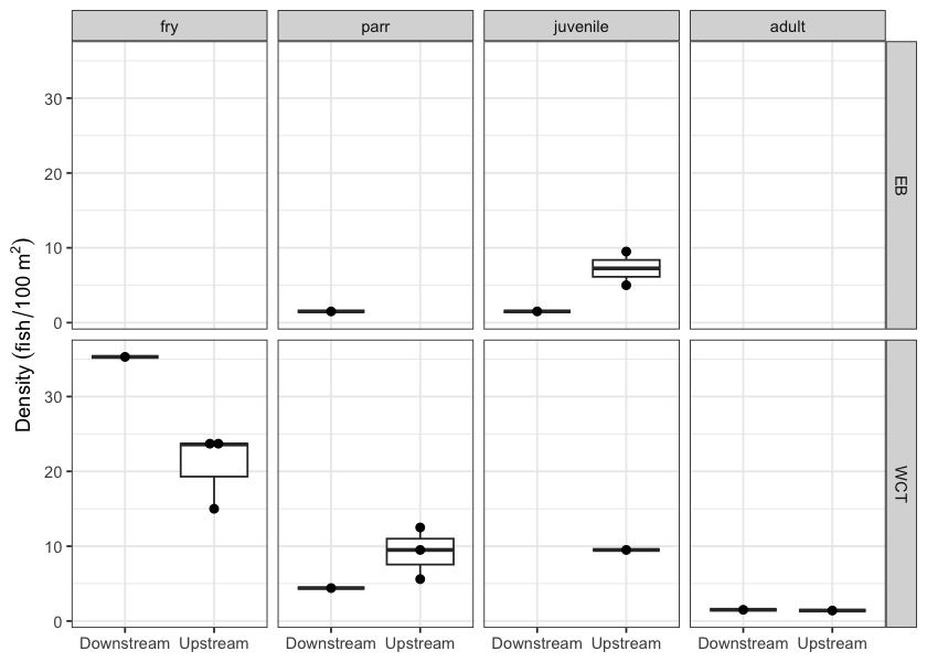
Figure 5.3: Fish densities (fish/100m2) for PSCIS crossing 50155.
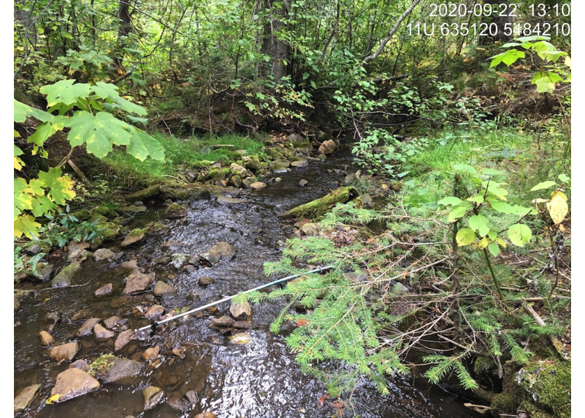
Figure 5.4: Typical habitat downstream of PSCIS crossing 50155.
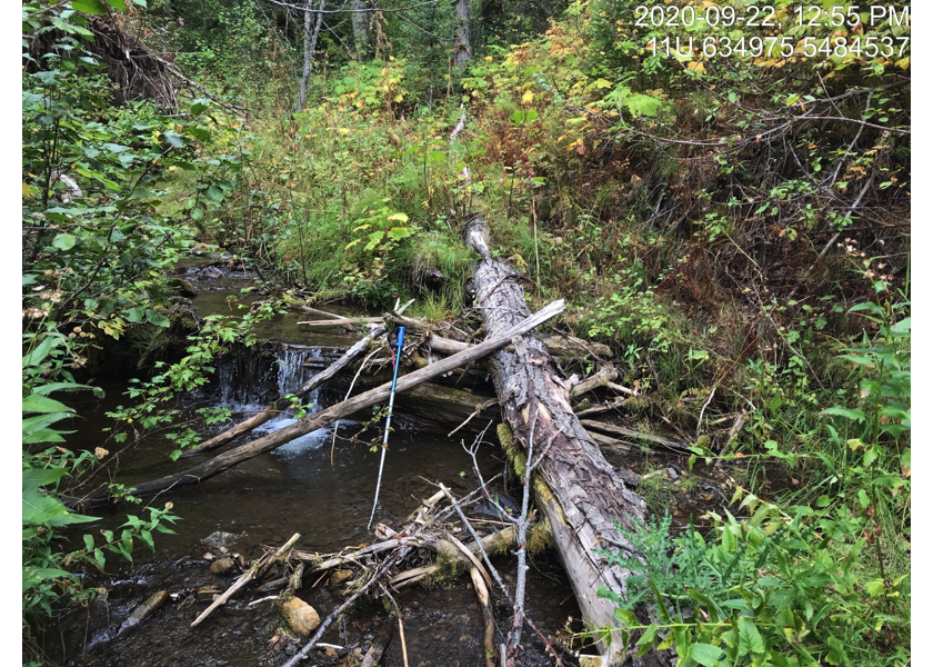
Figure 5.5: Typical habitat upstream of PSCIS crossing 50155.