Appendix - Phase 1 Fish Passage Assessment Data and Photos
| Location and Stream Data |
|
Crossing Characteristics | – |
|---|---|---|---|
| Date | 2020-10-16 | Crossing Sub Type | Round Culvert |
| PSCIS ID | – | Diameter (m) | 1.2 |
| External ID | 4600005 | Length (m) | 19 |
| Crew | AI, MF | Embedded | No |
| UTM Zone | 11 | Depth Embedded (m) | – |
| Easting | 638974 | Resemble Channel | No |
| Northing | 5484444 | Backwatered | No |
| Stream | Tributary to Elk R | Percent Backwatered | – |
| Road | Hwy 3 | Fill Depth (m) | 1.2 |
| Road Tenure | – | Outlet Drop (m) | 0.5 |
| Channel Width (m) | 2.7 | Outlet Pool Depth (m) | 0 |
| Stream Slope (%) | 6 | Inlet Drop | No |
| Beaver Activity | No | Slope (%) | 7 |
| Habitat Value | Low | Valley Fill | Deep Fill |
Photos: External ID 4600005. From top left clockwise: Road/Site Card, Barrel, Outlet, Downstream, Upstream, Inlet.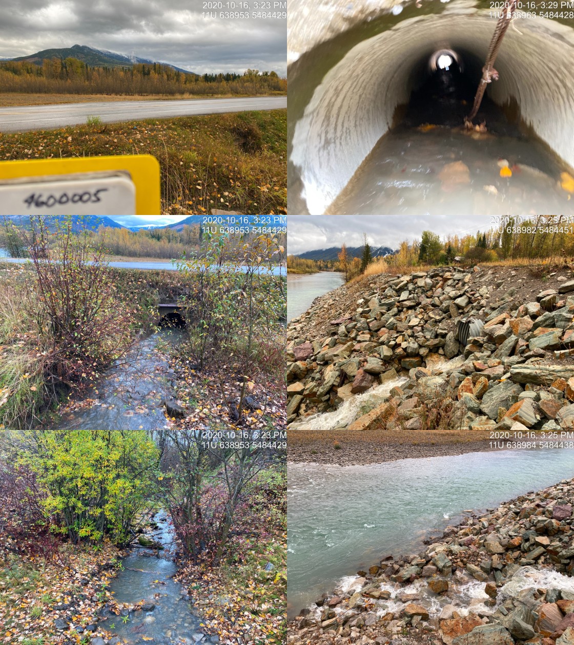
|
|||
| Comments: Difficult to discern if slpe (>60%) downstream between the highway the Elk River is due to highway fill or was naturally occurring before highway installation. |
| Location and Stream Data |
|
Crossing Characteristics | – |
|---|---|---|---|
| Date | 2020-09-23 | Crossing Sub Type | Round Culvert |
| PSCIS ID | 197548 | Diameter (m) | 0.65 |
| External ID | 4600008 | Length (m) | 11 |
| Crew | AI, KP | Embedded | Yes |
| UTM Zone | 11 | Depth Embedded (m) | 0.1 |
| Easting | 640268 | Resemble Channel | Yes |
| Northing | 5481377 | Backwatered | No |
| Stream | Tributary to Elk River | Percent Backwatered | – |
| Road | Robinson Road | Fill Depth (m) | 1.2 |
| Road Tenure | MoTi local | Outlet Drop (m) | 0 |
| Channel Width (m) | 1.2 | Outlet Pool Depth (m) | 0 |
| Stream Slope (%) | 0.5 | Inlet Drop | No |
| Beaver Activity | No | Slope (%) | 0.5 |
| Habitat Value | Low | Valley Fill | Deep Fill |
Photos: External ID 4600008. From top left clockwise: Road/Site Card, Barrel, Outlet, Downstream, Upstream, Inlet.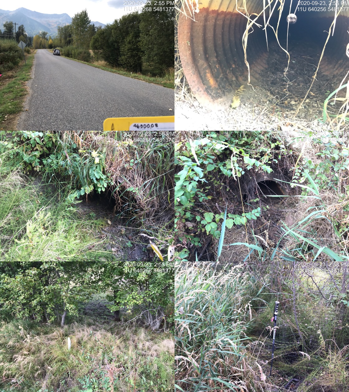
|
|||
| Comments: Dry mostly vegetated channel. Not likely fish habitat. |
| Location and Stream Data |
|
Crossing Characteristics | – |
|---|---|---|---|
| Date | 2020-09-24 | Crossing Sub Type | Round Culvert |
| PSCIS ID | 197580 | Diameter (m) | 0.6 |
| External ID | 4600026 | Length (m) | 22 |
| Crew | AI, MF, DN | Embedded | No |
| UTM Zone | 11 | Depth Embedded (m) | – |
| Easting | 642911 | Resemble Channel | No |
| Northing | 5490630 | Backwatered | No |
| Stream | Tributary to Elk River | Percent Backwatered | – |
| Road | Dicken Rd | Fill Depth (m) | 2 |
| Road Tenure | MoTi collector | Outlet Drop (m) | 1.3 |
| Channel Width (m) | 2.2 | Outlet Pool Depth (m) | 0.3 |
| Stream Slope (%) | 3 | Inlet Drop | No |
| Beaver Activity | No | Slope (%) | 1.5 |
| Habitat Value | Low | Valley Fill | Deep Fill |
Photos: External ID 4600026. From top left clockwise: Road/Site Card, Barrel, Outlet, Downstream, Upstream, Inlet.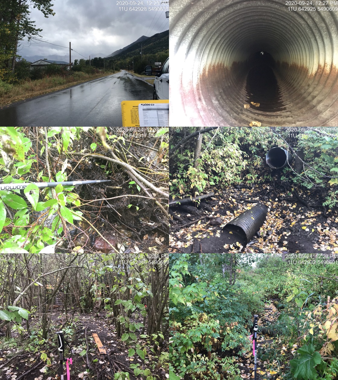
|
|||
| Comments: Stream dry at time of survey. Children’s fort in upstream channel indicating that flows are likely very minimal year round. |
| Location and Stream Data |
|
Crossing Characteristics | – |
|---|---|---|---|
| Date | 2020-09-24 | Crossing Sub Type | Round Culvert |
| PSCIS ID | 197581 | Diameter (m) | 0.95 |
| External ID | 4600028 | Length (m) | 14 |
| Crew | AI, MF, DN | Embedded | No |
| UTM Zone | 11 | Depth Embedded (m) | – |
| Easting | 642559 | Resemble Channel | No |
| Northing | 5490377 | Backwatered | No |
| Stream | Bean Creek | Percent Backwatered | – |
| Road | Dicken Rd | Fill Depth (m) | 1.2 |
| Road Tenure | MoTi collector | Outlet Drop (m) | 0.57 |
| Channel Width (m) | 2 | Outlet Pool Depth (m) | 0.22 |
| Stream Slope (%) | 5 | Inlet Drop | No |
| Beaver Activity | No | Slope (%) | 5.5 |
| Habitat Value | High | Valley Fill | Deep Fill |
Photos: External ID 4600028. From top left clockwise: Road/Site Card, Barrel, Outlet, Downstream, Upstream, Inlet.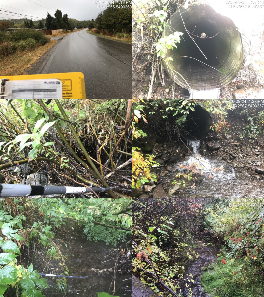
|
|||
| Comments: Multiple fish observed in outlet pool (~190mm). Some gravels suitable for spawning located upstream. |
| Location and Stream Data |
|
Crossing Characteristics | – |
|---|---|---|---|
| Date | 2020-09-17 | Crossing Sub Type | Round Culvert |
| PSCIS ID | 197531 | Diameter (m) | 0.75 |
| External ID | 4600037 | Length (m) | 6 |
| Crew | AI, KP | Embedded | Yes |
| UTM Zone | 11 | Depth Embedded (m) | 0.1 |
| Easting | 651867 | Resemble Channel | Yes |
| Northing | 5522741 | Backwatered | No |
| Stream | Dalzell Creek | Percent Backwatered | – |
| Road | Driveway | Fill Depth (m) | 0.3 |
| Road Tenure | private | Outlet Drop (m) | 0 |
| Channel Width (m) | 2.5 | Outlet Pool Depth (m) | 0 |
| Stream Slope (%) | 1.5 | Inlet Drop | No |
| Beaver Activity | No | Slope (%) | 2 |
| Habitat Value | Medium | Valley Fill | Deep Fill |
Photos: External ID 4600037. From top left clockwise: Road/Site Card, Barrel, Outlet, Downstream, Upstream, Inlet.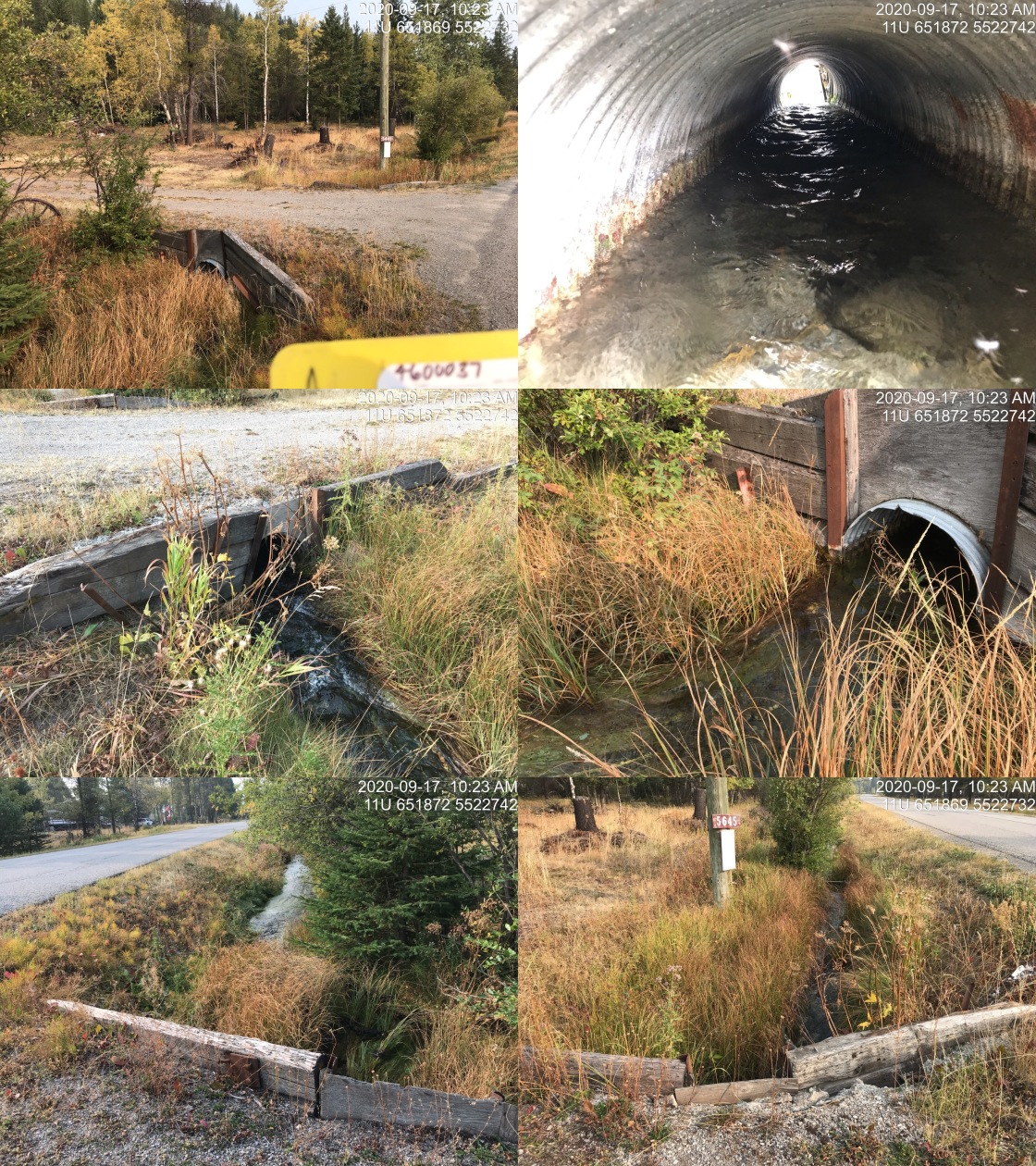
|
|||
| Comments: Embedded culvert on private driveway. EB known upstream. Culvert does not appear likely to be significantly impacting upstream fish passage for juvenile or adult WCT at time of survey. |
| Location and Stream Data |
|
Crossing Characteristics | – |
|---|---|---|---|
| Date | 2020-09-17 | Crossing Sub Type | Round Culvert |
| PSCIS ID | 197532 | Diameter (m) | 0.75 |
| External ID | 4600038 | Length (m) | 12 |
| Crew | AI, KP | Embedded | Yes |
| UTM Zone | 11 | Depth Embedded (m) | 0.18 |
| Easting | 651917 | Resemble Channel | Yes |
| Northing | 5522888 | Backwatered | No |
| Stream | Dalzell Creek | Percent Backwatered | – |
| Road | Driveway | Fill Depth (m) | 0.3 |
| Road Tenure | private | Outlet Drop (m) | 0 |
| Channel Width (m) | 1.2 | Outlet Pool Depth (m) | 0 |
| Stream Slope (%) | 1.5 | Inlet Drop | Yes |
| Beaver Activity | No | Slope (%) | 2 |
| Habitat Value | Medium | Valley Fill | Deep Fill |
Photos: External ID 4600038. From top left clockwise: Road/Site Card, Barrel, Outlet, Downstream, Upstream, Inlet.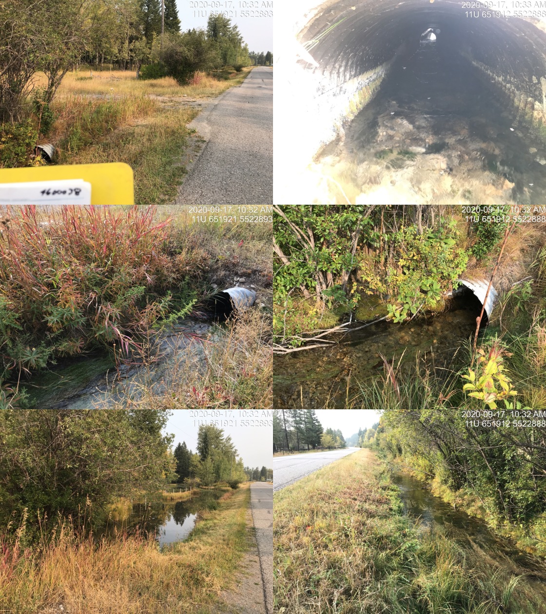
|
|||
| Comments: Culvert collapsing in the middle. Private resdience driveway. Wetland type habitat upstream. Culvert does not appear likely to be significantly impacting upstream fish passage for juvenile or adult WCT at time of survey. |
| Location and Stream Data |
|
Crossing Characteristics | – |
|---|---|---|---|
| Date | 2020-09-17 | Crossing Sub Type | Round Culvert |
| PSCIS ID | 197558 | Diameter (m) | 0.45 |
| External ID | 4600039 | Length (m) | 16 |
| Crew | KP, AI | Embedded | Yes |
| UTM Zone | 11 | Depth Embedded (m) | 0.07 |
| Easting | 651833 | Resemble Channel | Yes |
| Northing | 5522544 | Backwatered | No |
| Stream | Dalzell Creek | Percent Backwatered | – |
| Road | Lower Elk Valley Rd | Fill Depth (m) | 1 |
| Road Tenure | MoTi arterial | Outlet Drop (m) | 0 |
| Channel Width (m) | 3.8 | Outlet Pool Depth (m) | 0.07 |
| Stream Slope (%) | 1 | Inlet Drop | No |
| Beaver Activity | No | Slope (%) | 3.5 |
| Habitat Value | Medium | Valley Fill | Deep Fill |
Photos: External ID 4600039. From top left clockwise: Road/Site Card, Barrel, Outlet, Downstream, Upstream, Inlet.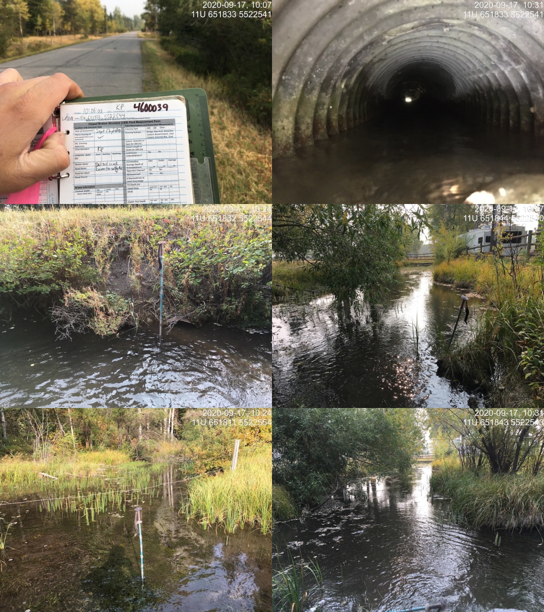
|
|||
| Comments: Three barrels (.45m each). Two of the three have water flowing through them. Upstream and downstream channel widens out, slow flow through vegetated channel. Highly manipulated banks. Deep fine substrate on both sides of crossing. Upstream resembles a wetland. Crossing does not appear likely to be significantly impacting upstream fish passage for juvenile or adult WCT at time of survey. |
| Location and Stream Data |
|
Crossing Characteristics | – |
|---|---|---|---|
| Date | 2020-09-17 | Crossing Sub Type | Round Culvert |
| PSCIS ID | 197530 | Diameter (m) | 0.9 |
| External ID | 4600040 | Length (m) | 22 |
| Crew | AI, KP | Embedded | Yes |
| UTM Zone | 11 | Depth Embedded (m) | 0.3 |
| Easting | 652004 | Resemble Channel | Yes |
| Northing | 5522330 | Backwatered | No |
| Stream | Dalzell Creek | Percent Backwatered | – |
| Road | Airport Road | Fill Depth (m) | 0.5 |
| Road Tenure | MoTi local | Outlet Drop (m) | 0 |
| Channel Width (m) | 5 | Outlet Pool Depth (m) | 0 |
| Stream Slope (%) | 0 | Inlet Drop | No |
| Beaver Activity | No | Slope (%) | 2.5 |
| Habitat Value | Medium | Valley Fill | Deep Fill |
Photos: External ID 4600040. From top left clockwise: Road/Site Card, Barrel, Outlet, Downstream, Upstream, Inlet.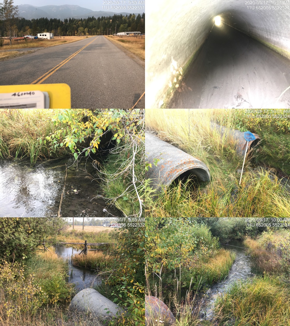
|
|||
| Comments: Fenced private land upstream and downstream. Wetland area downstream. Culvert does not appear likely to be significantly impacting upstream fish passage for juvenile or adult WCT at time of survey. |
| Location and Stream Data |
|
Crossing Characteristics | – |
|---|---|---|---|
| Date | 2020-09-17 | Crossing Sub Type | Round Culvert |
| PSCIS ID | 197534 | Diameter (m) | 3.2 |
| External ID | 4600069 | Length (m) | 18 |
| Crew | AI, KP | Embedded | No |
| UTM Zone | 11 | Depth Embedded (m) | – |
| Easting | 650144 | Resemble Channel | No |
| Northing | 5532055 | Backwatered | No |
| Stream | Weigart Creek | Percent Backwatered | – |
| Road | Highway 43 | Fill Depth (m) | 1.3 |
| Road Tenure | MoTi highway | Outlet Drop (m) | 0.15 |
| Channel Width (m) | 4.3 | Outlet Pool Depth (m) | 0.6 |
| Stream Slope (%) | 2 | Inlet Drop | Yes |
| Beaver Activity | No | Slope (%) | 3.4 |
| Habitat Value | High | Valley Fill | Deep Fill |
Photos: External ID 4600069. From top left clockwise: Road/Site Card, Barrel, Outlet, Downstream, Upstream, Inlet.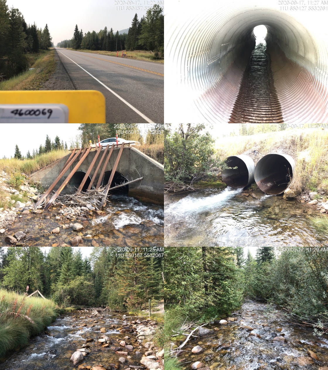
|
|||
| Comments: Large stream with good flow. Flows currently mostly through south culvert which has slightly higher outlet drop. Similar elevation outlets so added together for width. Lazer level used for culvert slope. Cobble/boulder substrate. Boulder cover. |
| Location and Stream Data |
|
Crossing Characteristics | – |
|---|---|---|---|
| Date | 2020-09-17 | Crossing Sub Type | Round Culvert |
| PSCIS ID | 197559 | Diameter (m) | 2.5 |
| External ID | 4600070 | Length (m) | 35 |
| Crew | KP, AI | Embedded | Yes |
| UTM Zone | 11 | Depth Embedded (m) | 0.05 |
| Easting | 651516 | Resemble Channel | Yes |
| Northing | 5528829 | Backwatered | No |
| Stream | Brule Creek | Percent Backwatered | – |
| Road | Highway 43 | Fill Depth (m) | 3 |
| Road Tenure | MoTi highway | Outlet Drop (m) | 0 |
| Channel Width (m) | 6.1 | Outlet Pool Depth (m) | 1.7 |
| Stream Slope (%) | 1.5 | Inlet Drop | No |
| Beaver Activity | No | Slope (%) | 2.5 |
| Habitat Value | Medium | Valley Fill | Deep Fill |
Photos: External ID 4600070. From top left clockwise: Road/Site Card, Barrel, Outlet, Downstream, Upstream, Inlet.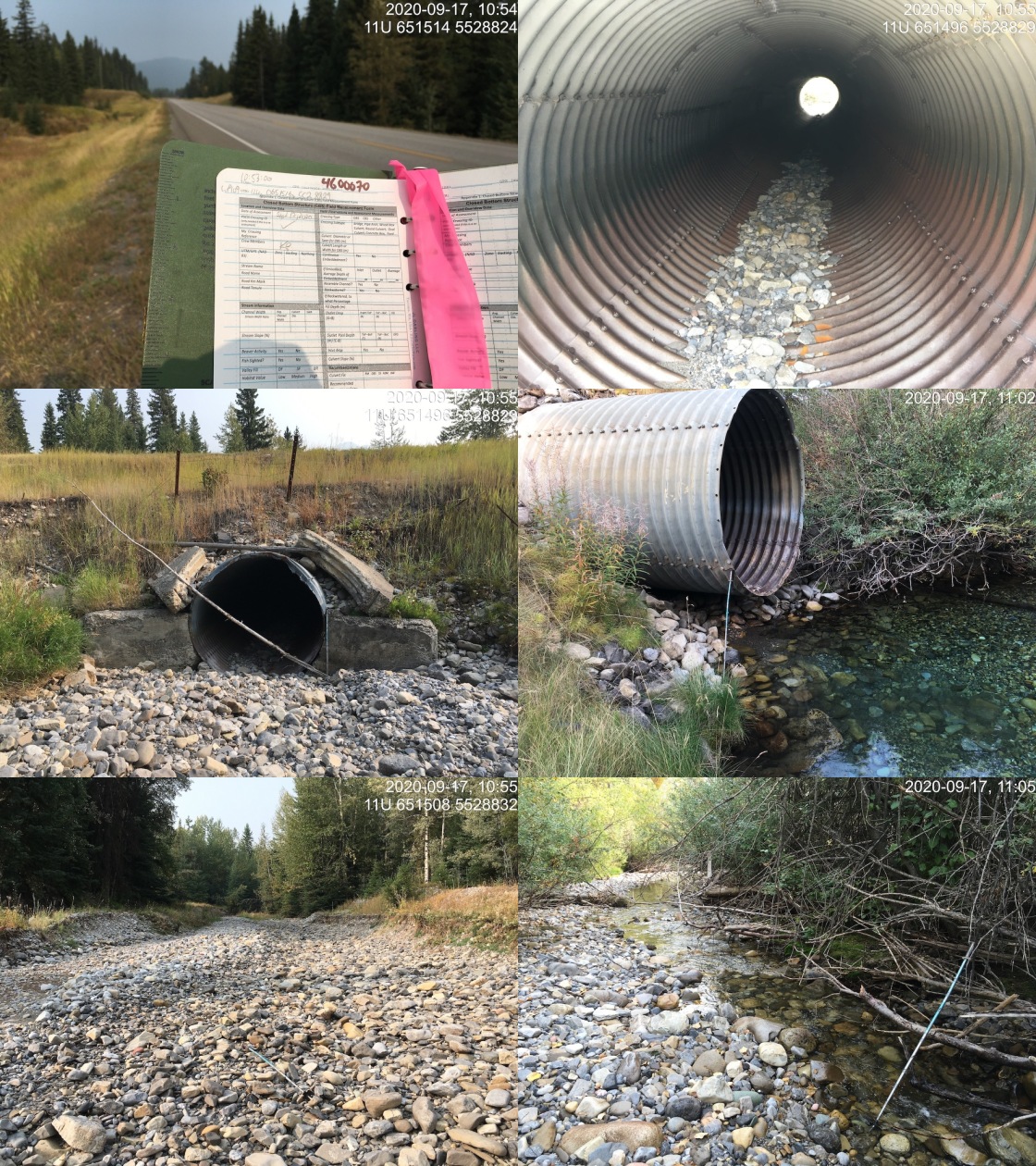
|
|||
| Comments: Dewatered upstream of highway for 600m. Deep pool present downstream fed subsurface from northside of culvert. Approximately 9 WCT in outlet pool. Four fish ~300mm and 5 fish ~200 mm. High confidence that the larger fish were WCT as easy to recognize spotted backs from bank. |
| Location and Stream Data |
|
Crossing Characteristics | – |
|---|---|---|---|
| Date | 2020-09-23 | Crossing Sub Type | Round Culvert |
| PSCIS ID | 197545 | Diameter (m) | 0.75 |
| External ID | 4600077 | Length (m) | 20 |
| Crew | AI, KP | Embedded | Yes |
| UTM Zone | 11 | Depth Embedded (m) | 0.1 |
| Easting | 639864 | Resemble Channel | Yes |
| Northing | 5483627 | Backwatered | No |
| Stream | Tributary to Elk River | Percent Backwatered | – |
| Road | Mt Mclean Road | Fill Depth (m) | 4 |
| Road Tenure | Fernie local | Outlet Drop (m) | 0 |
| Channel Width (m) | 2.7 | Outlet Pool Depth (m) | 0 |
| Stream Slope (%) | 0.5 | Inlet Drop | No |
| Beaver Activity | No | Slope (%) | 0.5 |
| Habitat Value | Low | Valley Fill | Deep Fill |
Photos: External ID 4600077. From top left clockwise: Road/Site Card, Barrel, Outlet, Downstream, Upstream, Inlet.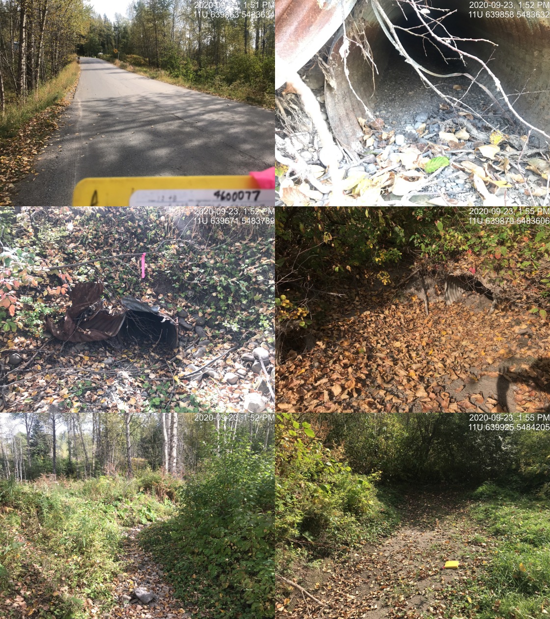
|
|||
| Comments: Dry channel. Culvert is embedded. |
| Location and Stream Data |
|
Crossing Characteristics | – |
|---|---|---|---|
| Date | 2020-09-23 | Crossing Sub Type | Round Culvert |
| PSCIS ID | 197569 | Diameter (m) | 1.1 |
| External ID | 4600080 | Length (m) | 43 |
| Crew | KP, AI | Embedded | No |
| UTM Zone | 11 | Depth Embedded (m) | – |
| Easting | 640568 | Resemble Channel | No |
| Northing | 5481516 | Backwatered | No |
| Stream | Tributary to Elk River | Percent Backwatered | – |
| Road | Cokato Road | Fill Depth (m) | 2 |
| Road Tenure | MoTi local | Outlet Drop (m) | 0 |
| Channel Width (m) | 2.1 | Outlet Pool Depth (m) | 0 |
| Stream Slope (%) | 3.5 | Inlet Drop | No |
| Beaver Activity | No | Slope (%) | 4 |
| Habitat Value | Low | Valley Fill | Deep Fill |
Photos: External ID 4600080. From top left clockwise: Road/Site Card, Barrel, Outlet, Downstream, Upstream, Inlet.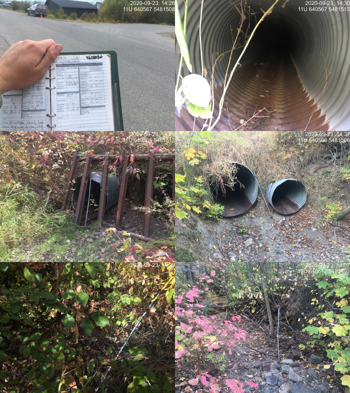
|
|||
| Comments: 2 barrels, 0.90 and 1.1m. Debris rack on inlet. Stream dry at time of survey. |
| Location and Stream Data |
|
Crossing Characteristics | – |
|---|---|---|---|
| Date | 2020-09-17 | Crossing Sub Type | Round Culvert |
| PSCIS ID | 197529 | Diameter (m) | 0.6 |
| External ID | 4600084 | Length (m) | 22 |
| Crew | AI, KP | Embedded | No |
| UTM Zone | 11 | Depth Embedded (m) | – |
| Easting | 651532 | Resemble Channel | No |
| Northing | 5521052 | Backwatered | No |
| Stream | Littlemoor Creek | Percent Backwatered | – |
| Road | Lower Elk Valley Rd | Fill Depth (m) | 0.8 |
| Road Tenure | MoTi arterial | Outlet Drop (m) | 0.2 |
| Channel Width (m) | 1 | Outlet Pool Depth (m) | 0.15 |
| Stream Slope (%) | 0.5 | Inlet Drop | No |
| Beaver Activity | No | Slope (%) | 3 |
| Habitat Value | Low | Valley Fill | Deep Fill |
Photos: External ID 4600084. From top left clockwise: Road/Site Card, Barrel, Outlet, Downstream, Upstream, Inlet.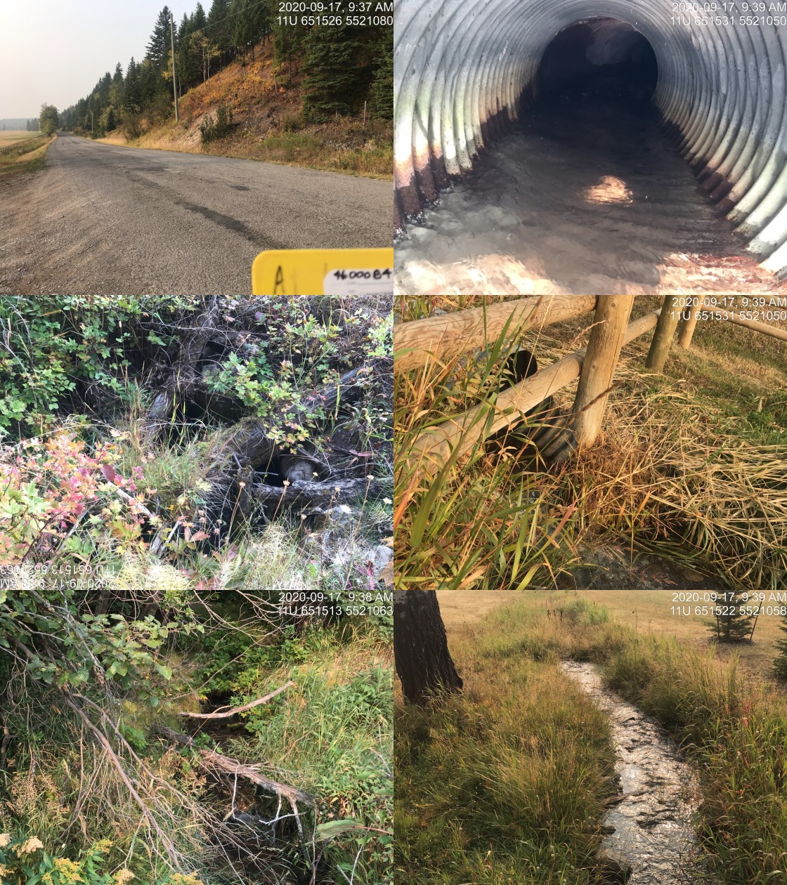
|
|||
| Comments: Flows through fenced private land upstream and downstream. Inlet has quite a bit of debris on it. Upstream is much steeper than downstream with gradient estimated at 12%. Small stream with good flow. |
| Location and Stream Data |
|
Crossing Characteristics | – |
|---|---|---|---|
| Date | 2020-09-17 | Crossing Sub Type | Round Culvert |
| PSCIS ID | 197556 | Diameter (m) | 0.45 |
| External ID | 4600090 | Length (m) | 18 |
| Crew | KP, AI | Embedded | No |
| UTM Zone | 11 | Depth Embedded (m) | – |
| Easting | 651814 | Resemble Channel | No |
| Northing | 5519652 | Backwatered | No |
| Stream | Tributary to Elk River | Percent Backwatered | – |
| Road | Lower Elk Valley Rd | Fill Depth (m) | 1 |
| Road Tenure | MoTi arterial | Outlet Drop (m) | 0 |
| Channel Width (m) | 0 | Outlet Pool Depth (m) | 0 |
| Stream Slope (%) | 0 | Inlet Drop | No |
| Beaver Activity | No | Slope (%) | 1.5 |
| Habitat Value | Low | Valley Fill | Deep Fill |
Photos: External ID 4600090. From top left clockwise: Road/Site Card, Barrel, Outlet, Downstream, Upstream, Inlet.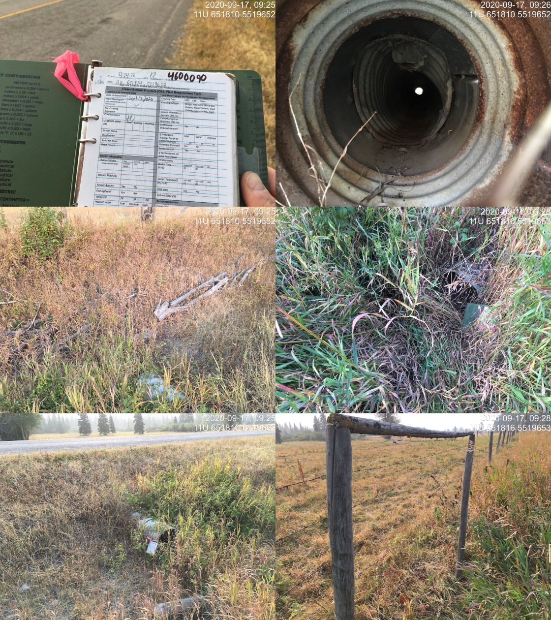
|
|||
| Comments: No visible channel. Not likely fish habitat. Agricultural area. |
| Location and Stream Data |
|
Crossing Characteristics | – |
|---|---|---|---|
| Date | 2020-09-17 | Crossing Sub Type | Round Culvert |
| PSCIS ID | 197557 | Diameter (m) | 0.8 |
| External ID | 4600092 | Length (m) | 18 |
| Crew | KP, AI | Embedded | No |
| UTM Zone | 11 | Depth Embedded (m) | – |
| Easting | 651701 | Resemble Channel | No |
| Northing | 5521881 | Backwatered | No |
| Stream | North Littlemoor Creek | Percent Backwatered | – |
| Road | Lower Elk Valley Rd | Fill Depth (m) | 0.6 |
| Road Tenure | MoTi arterial | Outlet Drop (m) | 0 |
| Channel Width (m) | 1.5 | Outlet Pool Depth (m) | 0 |
| Stream Slope (%) | 2.5 | Inlet Drop | No |
| Beaver Activity | No | Slope (%) | 3 |
| Habitat Value | Low | Valley Fill | Deep Fill |
Photos: External ID 4600092. From top left clockwise: Road/Site Card, Barrel, Outlet, Downstream, Upstream, Inlet.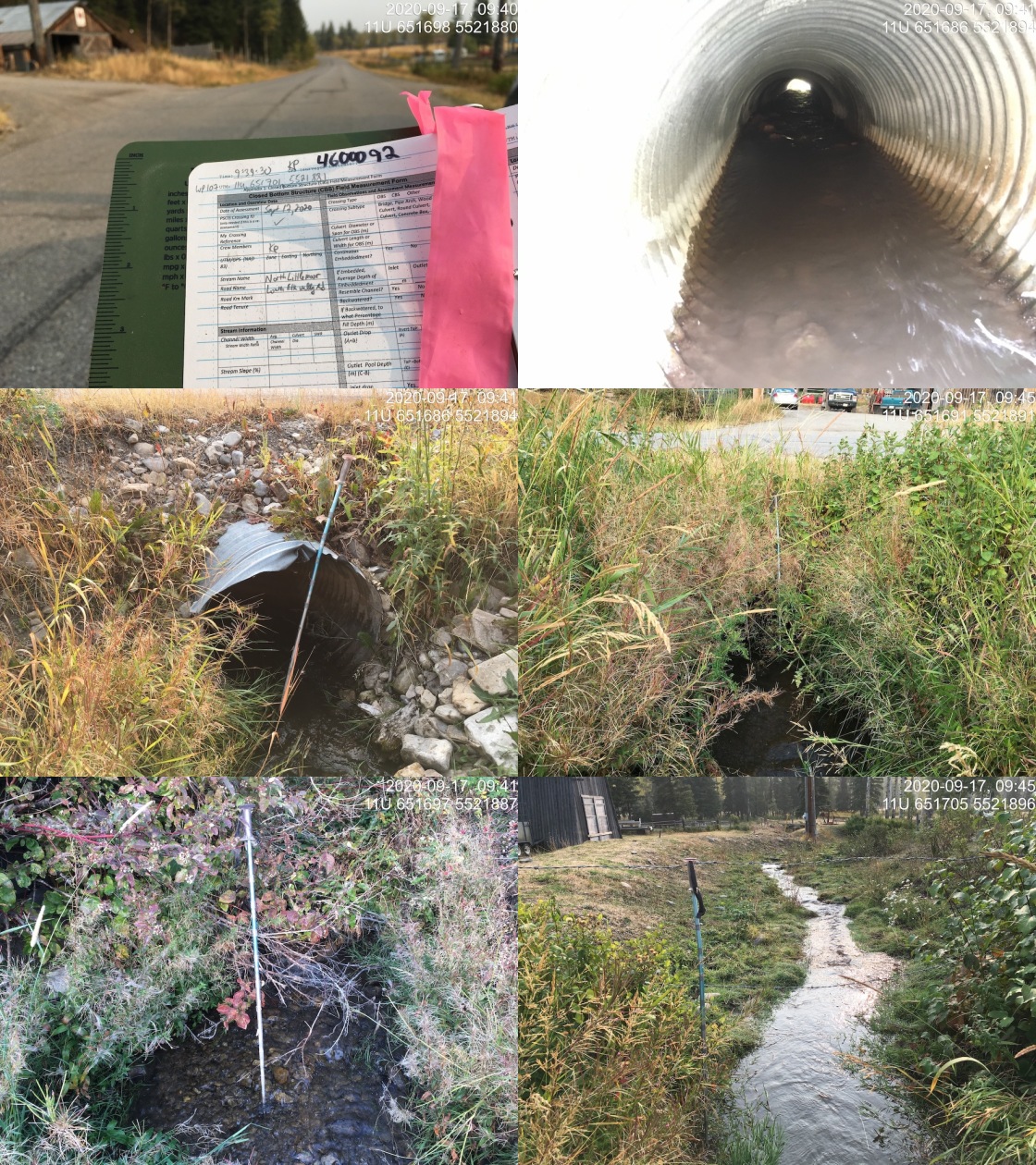
|
|||
| Comments: Stream slope estimated due to fenced private land. |
| Location and Stream Data |
|
Crossing Characteristics | – |
|---|---|---|---|
| Date | 2020-09-23 | Crossing Sub Type | Round Culvert |
| PSCIS ID | 197546 | Diameter (m) | 0.5 |
| External ID | 4600102 | Length (m) | 16 |
| Crew | AI, Kp | Embedded | No |
| UTM Zone | 11 | Depth Embedded (m) | – |
| Easting | 640306 | Resemble Channel | No |
| Northing | 5481672 | Backwatered | No |
| Stream | Tributary to Elk River | Percent Backwatered | – |
| Road | McGiverin Road | Fill Depth (m) | 1 |
| Road Tenure | MoTi local | Outlet Drop (m) | 0 |
| Channel Width (m) | 0.5 | Outlet Pool Depth (m) | 0 |
| Stream Slope (%) | 0 | Inlet Drop | No |
| Beaver Activity | No | Slope (%) | 1 |
| Habitat Value | Low | Valley Fill | Deep Fill |
Photos: External ID 4600102. From top left clockwise: Road/Site Card, Barrel, Outlet, Downstream, Upstream, Inlet.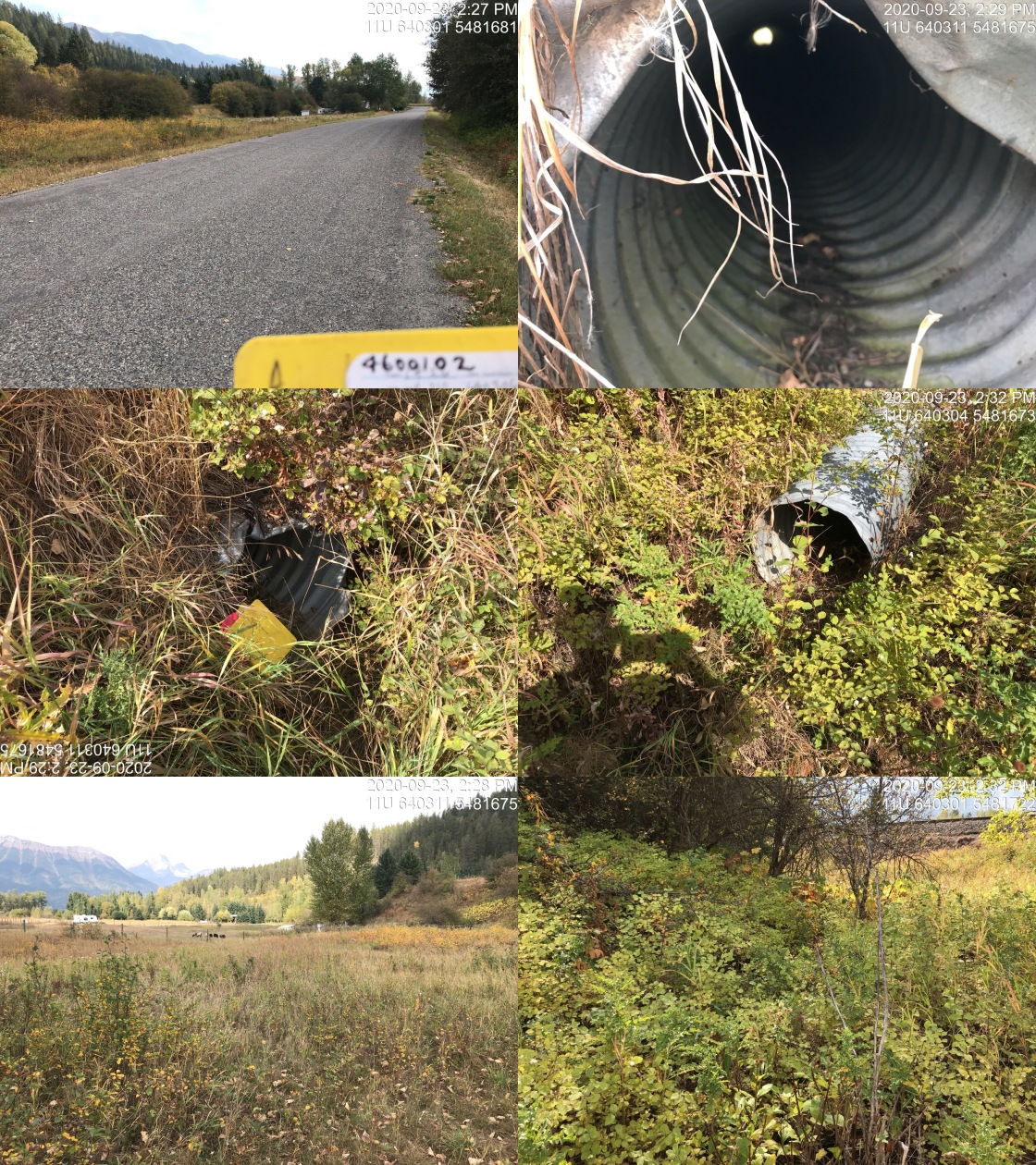
|
|||
| Comments: Vegetated channel. Not likely fish habitat. |
| Location and Stream Data |
|
Crossing Characteristics | – |
|---|---|---|---|
| Date | 2020-09-23 | Crossing Sub Type | Round Culvert |
| PSCIS ID | 197567 | Diameter (m) | 1.2 |
| External ID | 4600130 | Length (m) | 22 |
| Crew | KP, AI | Embedded | No |
| UTM Zone | 11 | Depth Embedded (m) | – |
| Easting | 640037 | Resemble Channel | No |
| Northing | 5483655 | Backwatered | Yes |
| Stream | Tributary to Elk River | Percent Backwatered | 20 |
| Road | Cokato Road | Fill Depth (m) | 8 |
| Road Tenure | Fernie collector | Outlet Drop (m) | 0 |
| Channel Width (m) | 0.65 | Outlet Pool Depth (m) | 0 |
| Stream Slope (%) | 9 | Inlet Drop | Yes |
| Beaver Activity | No | Slope (%) | 9 |
| Habitat Value | Low | Valley Fill | Deep Fill |
Photos: External ID 4600130. From top left clockwise: Road/Site Card, Barrel, Outlet, Downstream, Upstream, Inlet.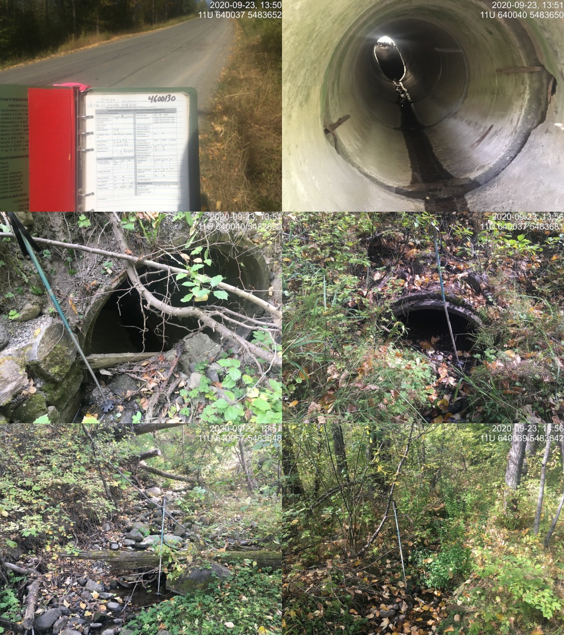
|
|||
| Comments: Very low flow at time of survey and 0.5m inlet drop from debris. Very steep culvert, possibly 2 sections with further upstream section being much steeper. |
| Location and Stream Data |
|
Crossing Characteristics | – |
|---|---|---|---|
| Date | 2020-09-24 | Crossing Sub Type | Round Culvert |
| PSCIS ID | 197574 | Diameter (m) | 0.9 |
| External ID | 4600134 | Length (m) | 48 |
| Crew | KP, AI | Embedded | No |
| UTM Zone | 11 | Depth Embedded (m) | – |
| Easting | 638639 | Resemble Channel | No |
| Northing | 5480681 | Backwatered | No |
| Stream | Tributary to Elk River | Percent Backwatered | – |
| Road | Fernie ski hill | Fill Depth (m) | 3 |
| Road Tenure | unclassified | Outlet Drop (m) | 0.09 |
| Channel Width (m) | 1.4 | Outlet Pool Depth (m) | 0.22 |
| Stream Slope (%) | 5 | Inlet Drop | No |
| Beaver Activity | No | Slope (%) | 9 |
| Habitat Value | Low | Valley Fill | Deep Fill |
Photos: External ID 4600134. From top left clockwise: Road/Site Card, Barrel, Outlet, Downstream, Upstream, Inlet.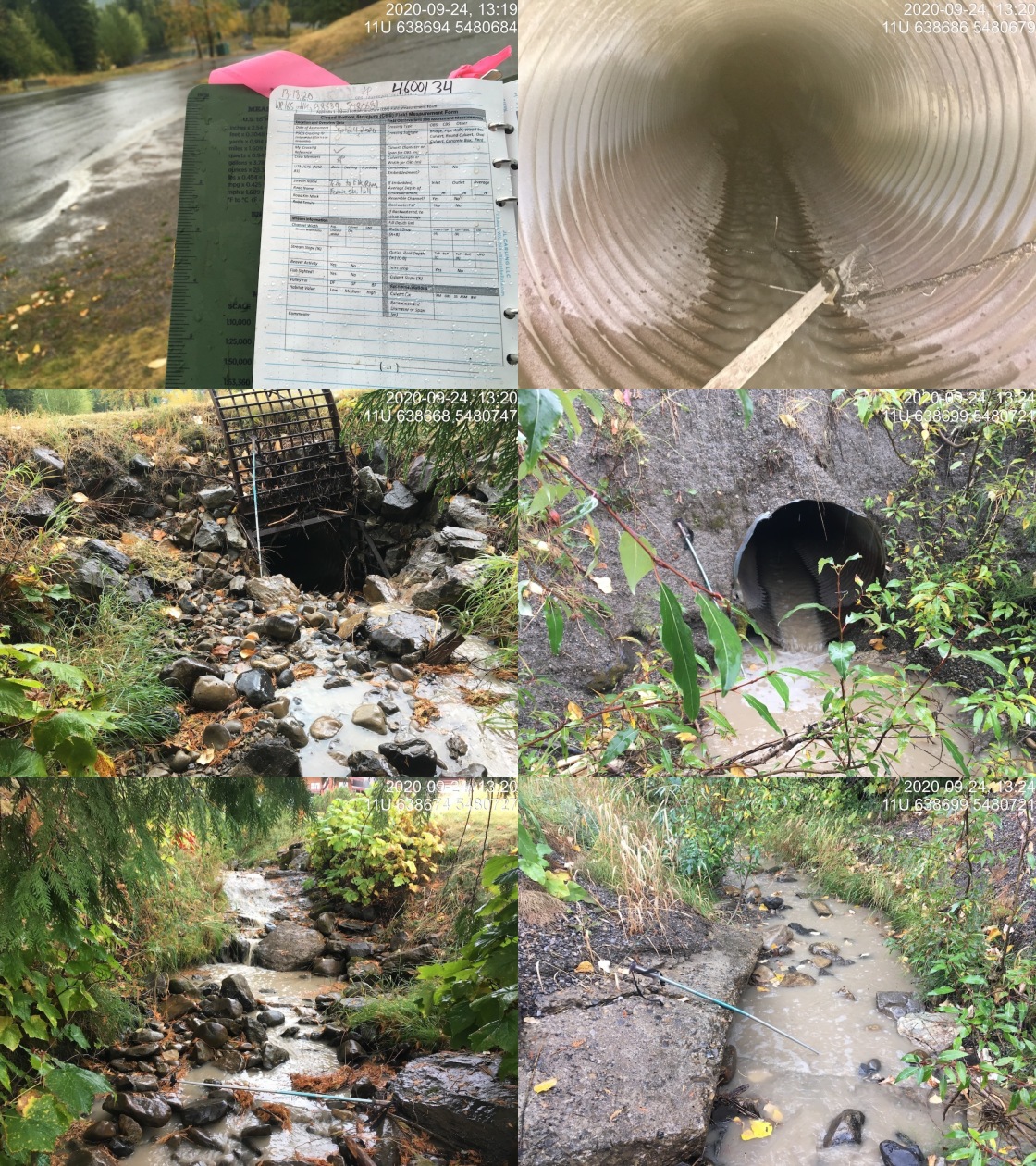
|
|||
| Comments: Debris guard on inlet. Unable to see through the culvert to other end. Highly manipulated banks, drains large parking area and ski hill. Steep with placed rocks (rip rap) in spots upstream. Stream goes under large turn around, paved area. Culvert likely >1 piece with slight angle. Armoured banks downstream, lots of sediment (sand) form pavement and parking area. |
| Location and Stream Data |
|
Crossing Characteristics | – |
|---|---|---|---|
| Date | 2020-09-18 | Crossing Sub Type | Round Culvert |
| PSCIS ID | 197562 | Diameter (m) | 0.9 |
| External ID | 4600140 | Length (m) | 22 |
| Crew | KP, AI | Embedded | No |
| UTM Zone | 11 | Depth Embedded (m) | – |
| Easting | 651110 | Resemble Channel | No |
| Northing | 5515356 | Backwatered | No |
| Stream | Whiting Creek | Percent Backwatered | – |
| Road | Highway 43 | Fill Depth (m) | 3 |
| Road Tenure | MoTi arterial | Outlet Drop (m) | 0.18 |
| Channel Width (m) | 0.6 | Outlet Pool Depth (m) | 0 |
| Stream Slope (%) | 2 | Inlet Drop | No |
| Beaver Activity | No | Slope (%) | 1.5 |
| Habitat Value | Low | Valley Fill | Deep Fill |
Photos: External ID 4600140. From top left clockwise: Road/Site Card, Barrel, Outlet, Downstream, Upstream, Inlet.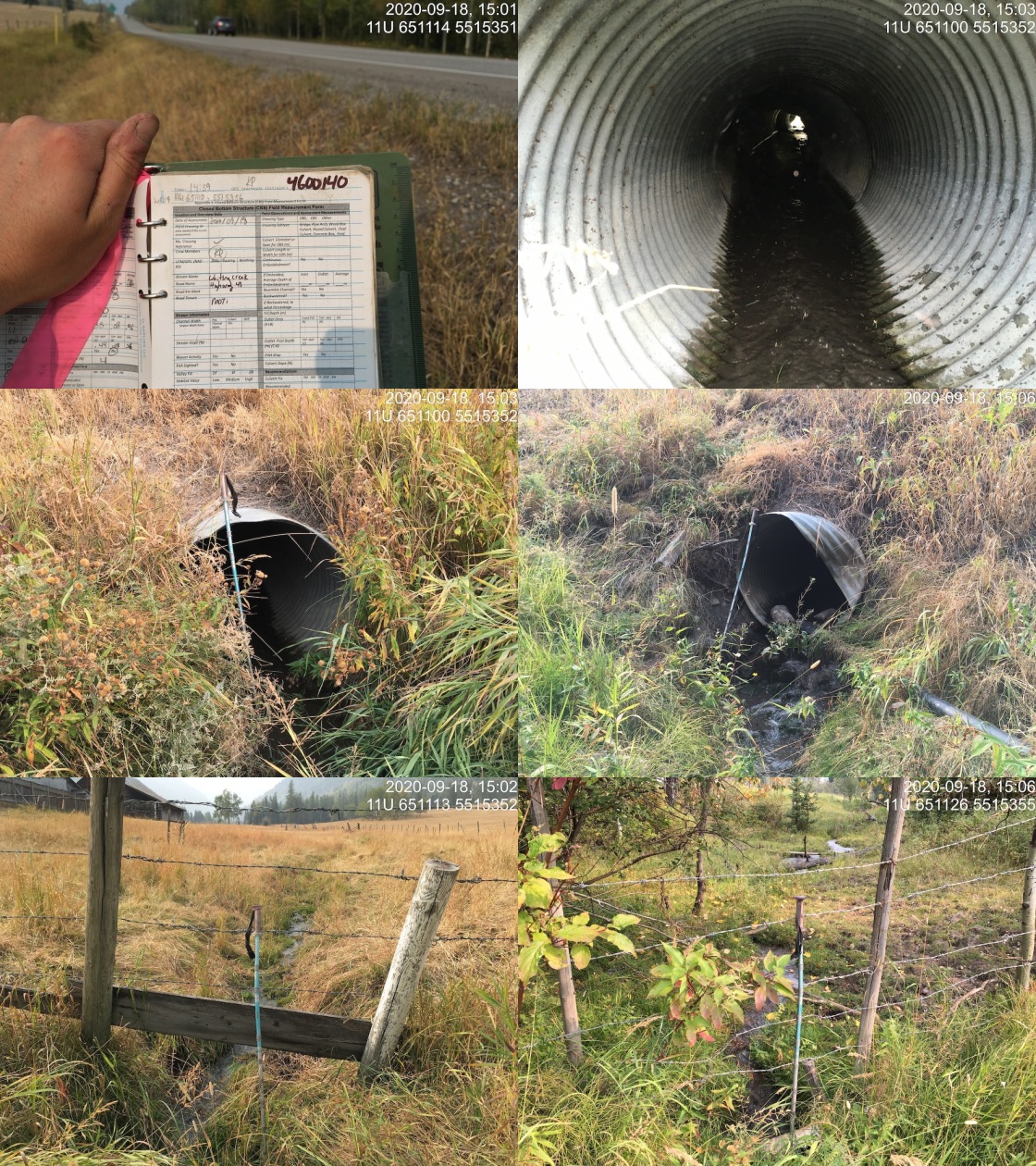
|
|||
| Comments: No access up or downstream due to fenced private land. Stream slope estimated. Water pipe intake at the outlet. |
| Location and Stream Data |
|
Crossing Characteristics | – |
|---|---|---|---|
| Date | 2020-09-24 | Crossing Sub Type | Pipe Arch |
| PSCIS ID | 197582 | Diameter (m) | 4 |
| External ID | 4600157 | Length (m) | 44 |
| Crew | AI, MF, DN | Embedded | – |
| UTM Zone | 11 | Depth Embedded (m) | – |
| Easting | 643565 | Resemble Channel | – |
| Northing | 5490325 | Backwatered | – |
| Stream | Hartley Creek | Percent Backwatered | – |
| Road | Highway 3 | Fill Depth (m) | – |
| Road Tenure | MoTi highway | Outlet Drop (m) | – |
| Channel Width (m) | – | Outlet Pool Depth (m) | – |
| Stream Slope (%) | – | Inlet Drop | – |
| Beaver Activity | No | Slope (%) | – |
| Habitat Value | – | Valley Fill | – |
Photos: External ID 4600157. From top left clockwise: Road/Site Card, Barrel, Outlet, Downstream, Upstream, Inlet.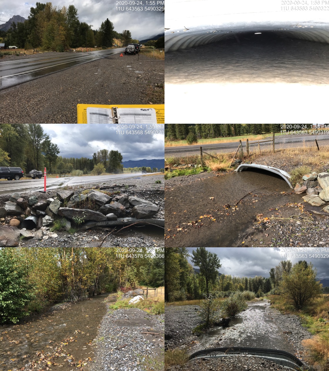
|
|||
| Comments: This crossing is very full of debris and has been recently dredges. Less than 30cm freeboard from top of aggraded gravels at inlet and top of pipe arch. Newly installed overflow pipe (0.55 diameter) on left bank. |
| Location and Stream Data |
|
Crossing Characteristics | – |
|---|---|---|---|
| Date | 2020-09-24 | Crossing Sub Type | Round Culvert |
| PSCIS ID | 197583 | Diameter (m) | 1.8 |
| External ID | 4600158 | Length (m) | 30 |
| Crew | AI, MF, DN | Embedded | No |
| UTM Zone | 11 | Depth Embedded (m) | – |
| Easting | 642739 | Resemble Channel | No |
| Northing | 5489444 | Backwatered | No |
| Stream | Bean Creek | Percent Backwatered | – |
| Road | Highway 3 | Fill Depth (m) | 1.5 |
| Road Tenure | MoTi highway | Outlet Drop (m) | 0.17 |
| Channel Width (m) | 3.2 | Outlet Pool Depth (m) | 0.24 |
| Stream Slope (%) | 0.5 | Inlet Drop | No |
| Beaver Activity | No | Slope (%) | 1 |
| Habitat Value | Medium | Valley Fill | Deep Fill |
Photos: External ID 4600158. From top left clockwise: Road/Site Card, Barrel, Outlet, Downstream, Upstream, Inlet.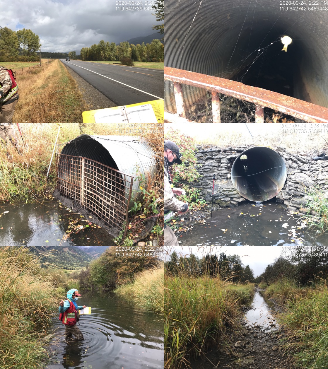
|
|||
| Comments: Fish observed at upstream crossing on Bean Rd. Grate on inlet may prevent passage off adult fish. Fill depth estimated from photos. |
| Location and Stream Data |
|
Crossing Characteristics | – |
|---|---|---|---|
| Date | 2020-09-24 | Crossing Sub Type | Round Culvert |
| PSCIS ID | 197573 | Diameter (m) | 1 |
| External ID | 4600169 | Length (m) | 36 |
| Crew | KP, AI | Embedded | No |
| UTM Zone | 11 | Depth Embedded (m) | – |
| Easting | 638850 | Resemble Channel | No |
| Northing | 5480833 | Backwatered | No |
| Stream | Tributary to Elk River | Percent Backwatered | – |
| Road | Highline Drive | Fill Depth (m) | 6 |
| Road Tenure | MoTi local | Outlet Drop (m) | 0.2 |
| Channel Width (m) | 2.3 | Outlet Pool Depth (m) | 0.25 |
| Stream Slope (%) | 11.5 | Inlet Drop | No |
| Beaver Activity | No | Slope (%) | 13 |
| Habitat Value | Medium | Valley Fill | Deep Fill |
Photos: External ID 4600169. From top left clockwise: Road/Site Card, Barrel, Outlet, Downstream, Upstream, Inlet.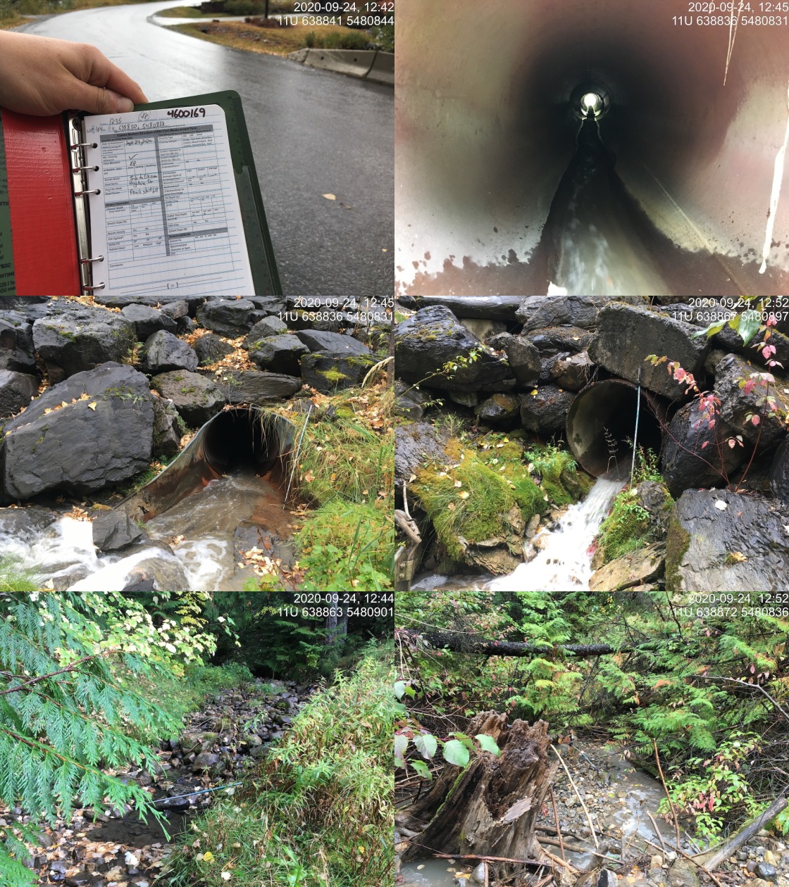
|
|||
| Comments: Very recent heavy rains, 2 side channels for ski hill drainage infrastructure giving significant flow contributions just upstream of crossing, one of which is especially turbid (from large parking lot). Culvert not baffled, very steep. A lot of fill on paved access to condos. Old metal collar of culvert ripped off and in outlet pool. |
| Location and Stream Data |
|
Crossing Characteristics | – |
|---|---|---|---|
| Date | 2020-09-18 | Crossing Sub Type | Round Culvert |
| PSCIS ID | 197560 | Diameter (m) | 0.6 |
| External ID | 4600181 | Length (m) | 73 |
| Crew | KP, AI | Embedded | No |
| UTM Zone | 11 | Depth Embedded (m) | – |
| Easting | 652322 | Resemble Channel | No |
| Northing | 5527529 | Backwatered | No |
| Stream | Tributary to Elk River | Percent Backwatered | – |
| Road | Line Creek Mine Rd | Fill Depth (m) | 3.5 |
| Road Tenure | MoTi local | Outlet Drop (m) | 0 |
| Channel Width (m) | 0.5 | Outlet Pool Depth (m) | 0 |
| Stream Slope (%) | 2 | Inlet Drop | No |
| Beaver Activity | No | Slope (%) | 2 |
| Habitat Value | Low | Valley Fill | Deep Fill |
Photos: External ID 4600181. From top left clockwise: Road/Site Card, Barrel, Outlet, Downstream, Upstream, Inlet.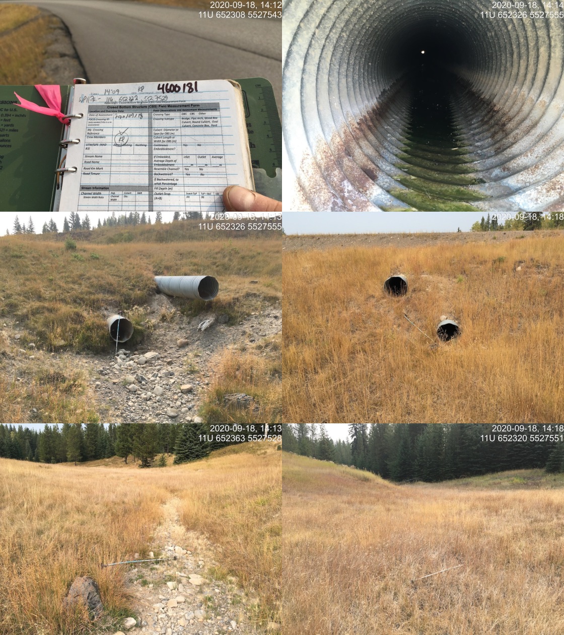
|
|||
| Comments: Dry at time of survey, no channel present, area vegetated grassland. Two culverts, 0.60m in diameter. Top culvert 0.5m higher than the lower. |
| Location and Stream Data |
|
Crossing Characteristics | – |
|---|---|---|---|
| Date | 2020-09-17 | Crossing Sub Type | Oval Culvert |
| PSCIS ID | 197533 | Diameter (m) | 3.3 |
| External ID | 4600183 | Length (m) | 20 |
| Crew | AI, KP | Embedded | No |
| UTM Zone | 11 | Depth Embedded (m) | – |
| Easting | 651626 | Resemble Channel | No |
| Northing | 5528888 | Backwatered | No |
| Stream | Brule Creek | Percent Backwatered | – |
| Road | Busato Road | Fill Depth (m) | 1 |
| Road Tenure | MoTi local | Outlet Drop (m) | 0.7 |
| Channel Width (m) | 7.1 | Outlet Pool Depth (m) | 1.5 |
| Stream Slope (%) | 2 | Inlet Drop | Yes |
| Beaver Activity | No | Slope (%) | 4 |
| Habitat Value | High | Valley Fill | Deep Fill |
Photos: External ID 4600183. From top left clockwise: Road/Site Card, Barrel, Outlet, Downstream, Upstream, Inlet.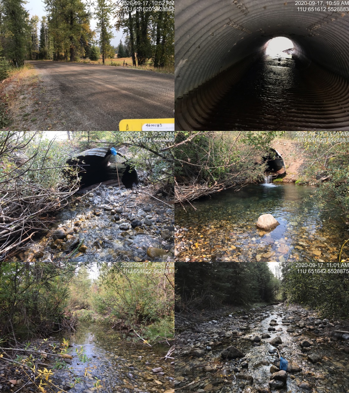
|
|||
| Comments: Large stream with good flow at this crossing. Culvert inlet is damaged and there is a large outlet drop. Upstream of highway the stream is subsurface for ~600m. |
| Location and Stream Data |
|
Crossing Characteristics | – |
|---|---|---|---|
| Date | 2020-09-18 | Crossing Sub Type | Round Culvert |
| PSCIS ID | 197537 | Diameter (m) | 0.6 |
| External ID | 4600184 | Length (m) | 30 |
| Crew | AI, KP | Embedded | No |
| UTM Zone | 11 | Depth Embedded (m) | – |
| Easting | 650954 | Resemble Channel | No |
| Northing | 5522199 | Backwatered | No |
| Stream | North Littlemoor Creek | Percent Backwatered | – |
| Road | Highway 43 | Fill Depth (m) | 4 |
| Road Tenure | MoTi highway | Outlet Drop (m) | 0.65 |
| Channel Width (m) | 1.6 | Outlet Pool Depth (m) | 0.55 |
| Stream Slope (%) | 5 | Inlet Drop | No |
| Beaver Activity | No | Slope (%) | 8 |
| Habitat Value | Medium | Valley Fill | Deep Fill |
Photos: External ID 4600184. From top left clockwise: Road/Site Card, Barrel, Outlet, Downstream, Upstream, Inlet.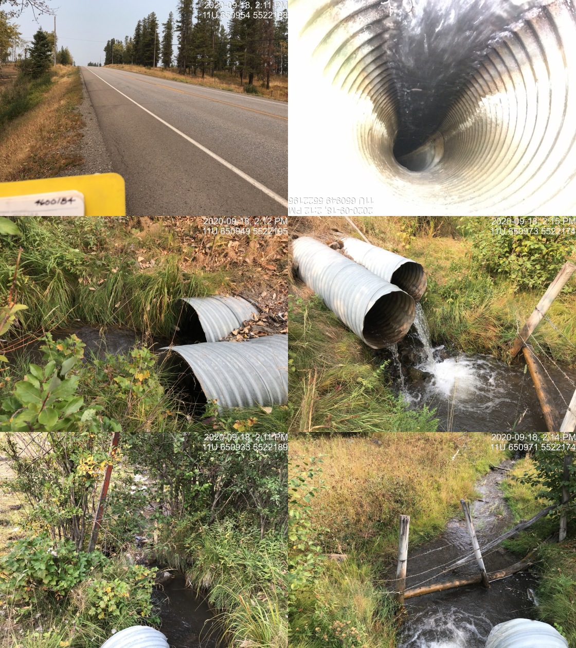
|
|||
| Comments: Small stream with good flow, EB known upstream. Fenced private land upstream and downstream. Stream measurements estimated due to fenced private land. Large outlet drop. |
| Location and Stream Data |
|
Crossing Characteristics | – |
|---|---|---|---|
| Date | 2020-09-18 | Crossing Sub Type | Round Culvert |
| PSCIS ID | 197538 | Diameter (m) | 0.9 |
| External ID | 4600185 | Length (m) | 40 |
| Crew | AI, KP | Embedded | No |
| UTM Zone | 11 | Depth Embedded (m) | – |
| Easting | 651002 | Resemble Channel | No |
| Northing | 5521022 | Backwatered | No |
| Stream | Littlemoor Creek | Percent Backwatered | – |
| Road | Highway 43 | Fill Depth (m) | 5 |
| Road Tenure | MoTi highway | Outlet Drop (m) | 0.3 |
| Channel Width (m) | 1.2 | Outlet Pool Depth (m) | 0.55 |
| Stream Slope (%) | 3.5 | Inlet Drop | Yes |
| Beaver Activity | No | Slope (%) | 5 |
| Habitat Value | Medium | Valley Fill | Deep Fill |
Photos: External ID 4600185. From top left clockwise: Road/Site Card, Barrel, Outlet, Downstream, Upstream, Inlet.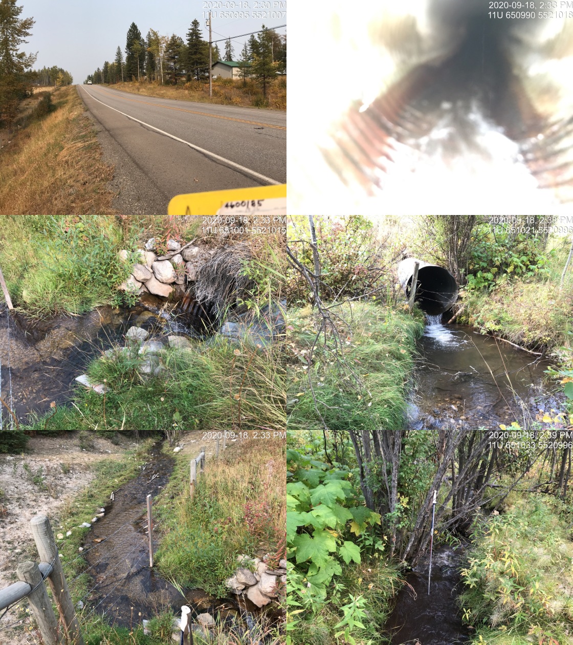
|
|||
| Comments: Culvert has extension with corner, small stream with good flow. WCT and EB documented upstream. Gravels present suitable for WCT and EB spawning. |
| Location and Stream Data |
|
Crossing Characteristics | – |
|---|---|---|---|
| Date | 2020-09-18 | Crossing Sub Type | Round Culvert |
| PSCIS ID | 197561 | Diameter (m) | 0.8 |
| External ID | 4600186 | Length (m) | 22 |
| Crew | KP, AI | Embedded | No |
| UTM Zone | 11 | Depth Embedded (m) | – |
| Easting | 651051 | Resemble Channel | No |
| Northing | 5519343 | Backwatered | No |
| Stream | Hollow Creek | Percent Backwatered | – |
| Road | Highway 43 | Fill Depth (m) | 0.8 |
| Road Tenure | MoTi highway | Outlet Drop (m) | 0.46 |
| Channel Width (m) | 1.1 | Outlet Pool Depth (m) | 0.36 |
| Stream Slope (%) | 2 | Inlet Drop | No |
| Beaver Activity | No | Slope (%) | 4 |
| Habitat Value | Low | Valley Fill | Deep Fill |
Photos: External ID 4600186. From top left clockwise: Road/Site Card, Barrel, Outlet, Downstream, Upstream, Inlet.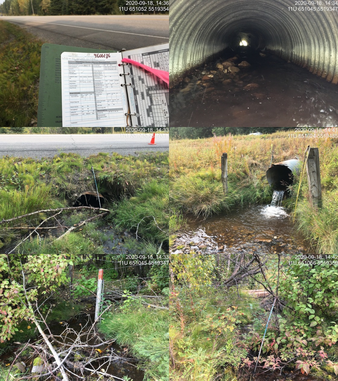
|
|||
| Comments: No access up or downstream due to fenced private land. Stream slope estimated. |
| Location and Stream Data |
|
Crossing Characteristics | – |
|---|---|---|---|
| Date | 2020-09-23 | Crossing Sub Type | Round Culvert |
| PSCIS ID | 197571 | Diameter (m) | 1.2 |
| External ID | 4600316 | Length (m) | 12 |
| Crew | KP, AI | Embedded | No |
| UTM Zone | 11 | Depth Embedded (m) | – |
| Easting | 641167 | Resemble Channel | No |
| Northing | 5479429 | Backwatered | No |
| Stream | Tributary to Elk River | Percent Backwatered | – |
| Road | Cokato Road | Fill Depth (m) | 0.5 |
| Road Tenure | MoTi local | Outlet Drop (m) | 0 |
| Channel Width (m) | 4.1 | Outlet Pool Depth (m) | 0 |
| Stream Slope (%) | 4 | Inlet Drop | No |
| Beaver Activity | No | Slope (%) | 2.5 |
| Habitat Value | Low | Valley Fill | Deep Fill |
Photos: External ID 4600316. From top left clockwise: Road/Site Card, Barrel, Outlet, Downstream, Upstream, Inlet.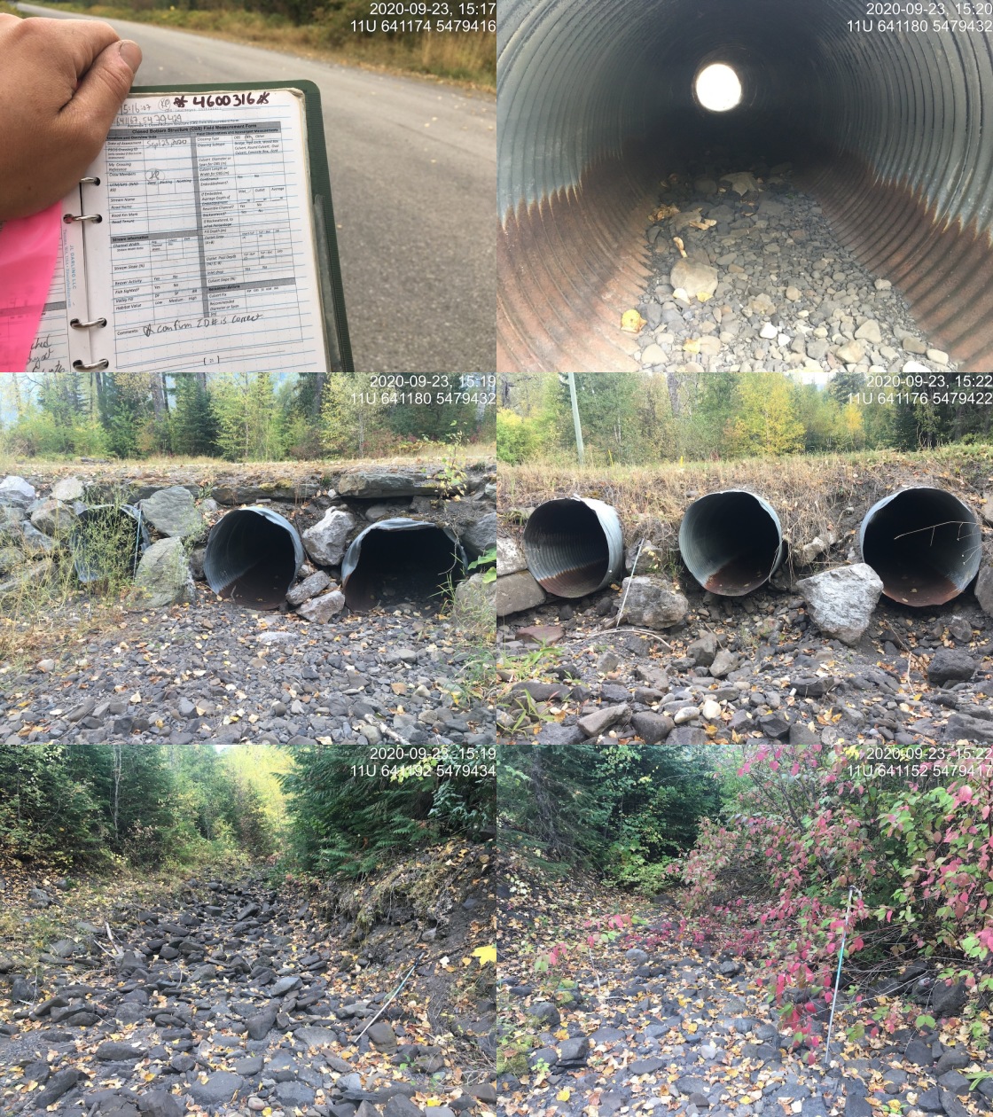
|
|||
| Comments: Stream dry at time of survey. Three barrels, 1.2m in diameter. All three very similar elevation, all perched .2-.50m above substrate. |
| Location and Stream Data |
|
Crossing Characteristics | – |
|---|---|---|---|
| Date | 2020-09-17 | Crossing Sub Type | Round Culvert |
| PSCIS ID | 197528 | Diameter (m) | 0.6 |
| External ID | 4600329 | Length (m) | 12 |
| Crew | AI, KP | Embedded | No |
| UTM Zone | 11 | Depth Embedded (m) | – |
| Easting | 652325 | Resemble Channel | Yes |
| Northing | 5515789 | Backwatered | No |
| Stream | Tributary to Whiting Creek | Percent Backwatered | – |
| Road | Lower Elk Valley Rd | Fill Depth (m) | 1 |
| Road Tenure | MoTi arterial | Outlet Drop (m) | 0 |
| Channel Width (m) | 0.5 | Outlet Pool Depth (m) | 0 |
| Stream Slope (%) | 0 | Inlet Drop | No |
| Beaver Activity | No | Slope (%) | 1 |
| Habitat Value | Low | Valley Fill | Deep Fill |
Photos: External ID 4600329. From top left clockwise: Road/Site Card, Barrel, Outlet, Downstream, Upstream, Inlet.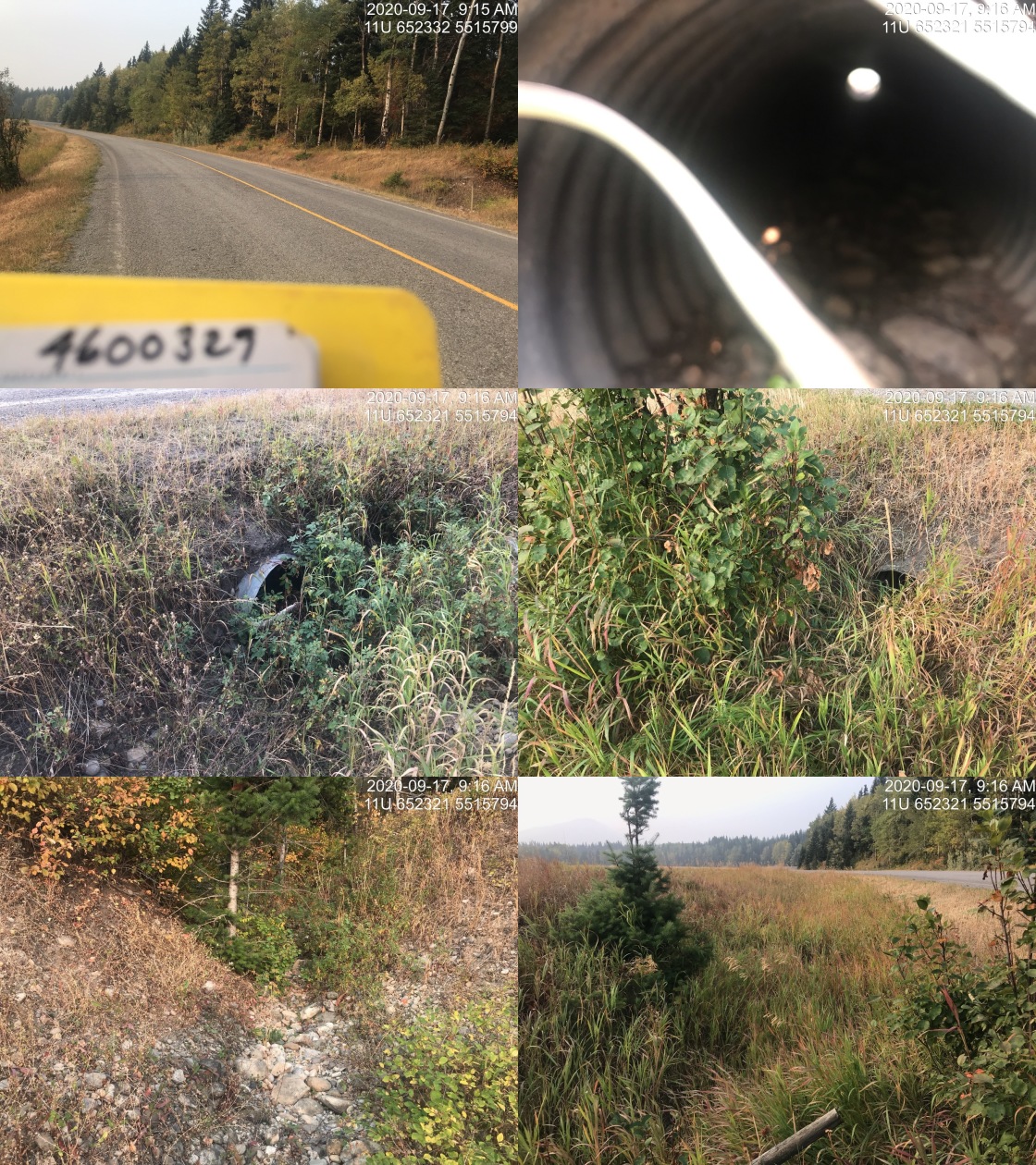
|
|||
| Comments: Whiting creek appeared to not be present through agricultural field downstream. This appeared to be only channel present for Whiting crossing this road although the main Whiting channel is present upstream. Dry, heavily vegetated channel downstream. Defined channel upstream but seems unlikely to be fish bearing. |
| Location and Stream Data |
|
Crossing Characteristics | – |
|---|---|---|---|
| Date | 2020-09-24 | Crossing Sub Type | Round Culvert |
| PSCIS ID | 197579 | Diameter (m) | 1.2 |
| External ID | 4600332 | Length (m) | 25 |
| Crew | AI, KP | Embedded | No |
| UTM Zone | 11 | Depth Embedded (m) | – |
| Easting | 639511 | Resemble Channel | No |
| Northing | 5481114 | Backwatered | No |
| Stream | Tributary to Elk River | Percent Backwatered | – |
| Road | Highway 3 | Fill Depth (m) | 2.3 |
| Road Tenure | MoTi highway | Outlet Drop (m) | 0 |
| Channel Width (m) | 3.3 | Outlet Pool Depth (m) | 0.5 |
| Stream Slope (%) | 4 | Inlet Drop | Yes |
| Beaver Activity | No | Slope (%) | 1.5 |
| Habitat Value | Medium | Valley Fill | Deep Fill |
Photos: External ID 4600332. From top left clockwise: Road/Site Card, Barrel, Outlet, Downstream, Upstream, Inlet.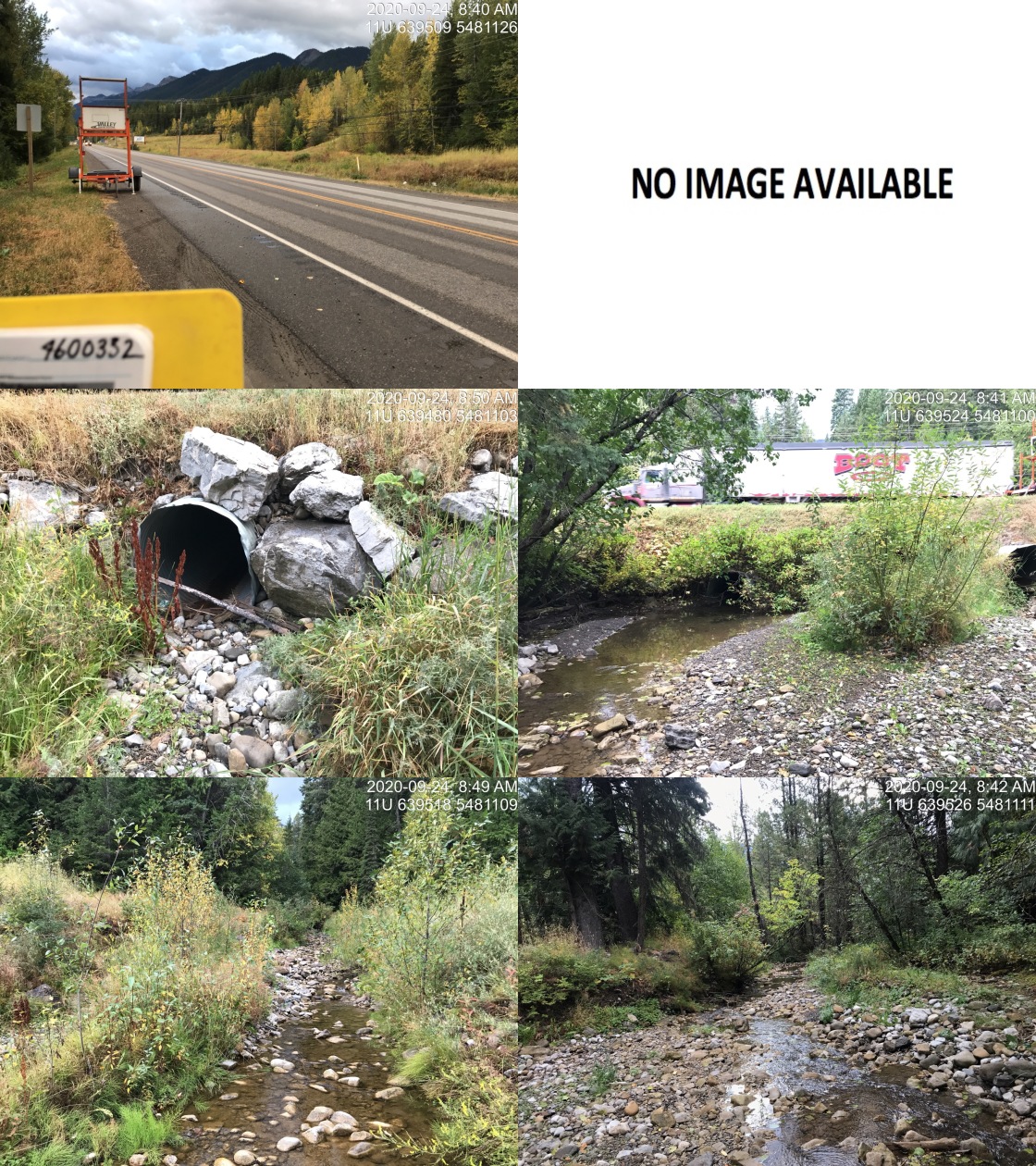
|
|||
| Comments: Fry observed at outlet pool. Inlet of active pipe mostly plugged with debris. Overflow pipe is 0.8m outlet drop with fry/juveniles stranded in outlet pool. Flows out of Fernie Ski Hill Road development area. |
| Location and Stream Data |
|
Crossing Characteristics | – |
|---|---|---|---|
| Date | 2020-09-18 | Crossing Sub Type | Oval Culvert |
| PSCIS ID | 197542 | Diameter (m) | 2.6 |
| External ID | 4600367 | Length (m) | 20 |
| Crew | AI, KP | Embedded | No |
| UTM Zone | 11 | Depth Embedded (m) | – |
| Easting | 643534 | Resemble Channel | No |
| Northing | 5490723 | Backwatered | No |
| Stream | Hartley Creek | Percent Backwatered | – |
| Road | Dicken Road | Fill Depth (m) | 0.4 |
| Road Tenure | MoTi collector | Outlet Drop (m) | 0.4 |
| Channel Width (m) | 3.5 | Outlet Pool Depth (m) | 0.8 |
| Stream Slope (%) | 1 | Inlet Drop | No |
| Beaver Activity | No | Slope (%) | 2 |
| Habitat Value | High | Valley Fill | Deep Fill |
Photos: External ID 4600367. From top left clockwise: Road/Site Card, Barrel, Outlet, Downstream, Upstream, Inlet.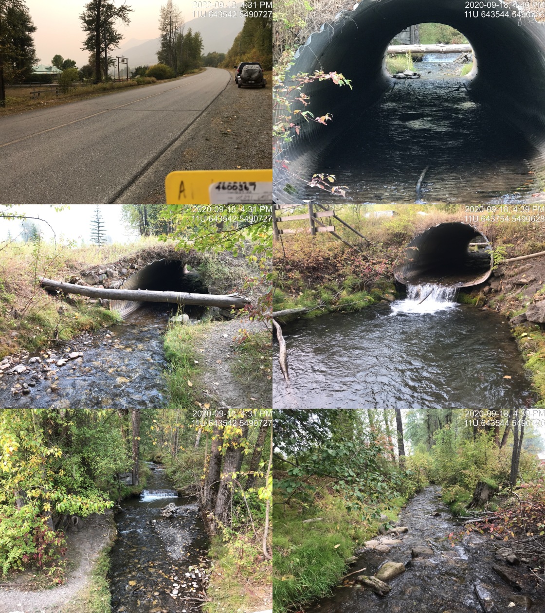
|
|||
| Comments: Laser level used for culvert slope. WCT spawning system. See Management Plan for the Westslope Cutthroat Trout (Oncorhynchus clarkii lewisi) in British Columbia 2014 http://a100.gov.bc.ca/pub/eirs/finishDownloadDocument.do?subdocumentId=9781 |
| Location and Stream Data |
|
Crossing Characteristics | – |
|---|---|---|---|
| Date | 2020-09-20 | Crossing Sub Type | Ford |
| PSCIS ID | 197563 | Diameter (m) | – |
| External ID | 4601129 | Length (m) | – |
| Crew | KP, AI | Embedded | – |
| UTM Zone | 11 | Depth Embedded (m) | – |
| Easting | 661062 | Resemble Channel | – |
| Northing | 5524446 | Backwatered | – |
| Stream | Grave Creek | Percent Backwatered | – |
| Road | – | Fill Depth (m) | – |
| Road Tenure | unclassified | Outlet Drop (m) | – |
| Channel Width (m) | – | Outlet Pool Depth (m) | – |
| Stream Slope (%) | – | Inlet Drop | – |
| Beaver Activity | No | Slope (%) | – |
| Habitat Value | – | Valley Fill | – |
Photos: External ID 4601129. From top left clockwise: Road/Site Card, Barrel, Outlet, Downstream, Upstream, Inlet.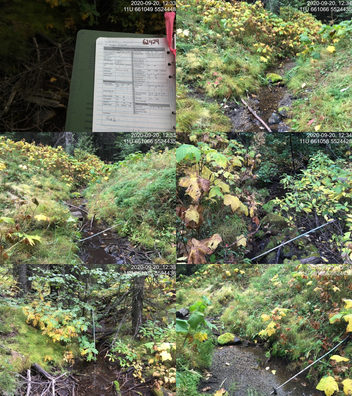
|
|||
| Comments: Deactivated road. Ford. |
| Location and Stream Data |
|
Crossing Characteristics | – |
|---|---|---|---|
| Date | 2020-09-18 | Crossing Sub Type | Ford |
| PSCIS ID | 197535 | Diameter (m) | – |
| External ID | 4601205 | Length (m) | – |
| Crew | AI, KP | Embedded | – |
| UTM Zone | 11 | Depth Embedded (m) | – |
| Easting | 650917 | Resemble Channel | – |
| Northing | 5528513 | Backwatered | – |
| Stream | Brule Creek | Percent Backwatered | – |
| Road | Private | Fill Depth (m) | – |
| Road Tenure | private | Outlet Drop (m) | – |
| Channel Width (m) | – | Outlet Pool Depth (m) | – |
| Stream Slope (%) | – | Inlet Drop | – |
| Beaver Activity | No | Slope (%) | – |
| Habitat Value | – | Valley Fill | – |
Photos: External ID 4601205. From top left clockwise: Road/Site Card, Barrel, Outlet, Downstream, Upstream, Inlet.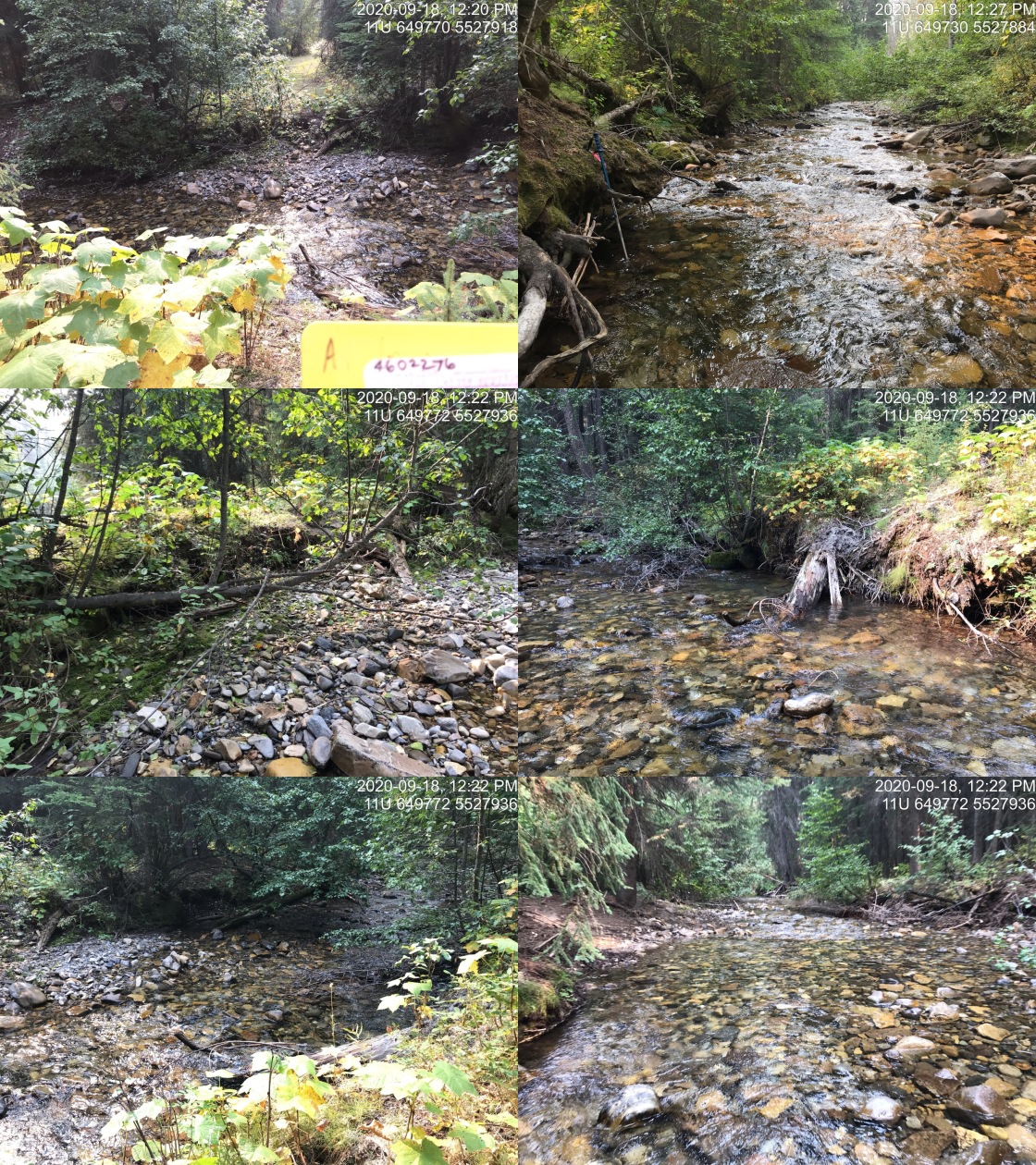
|
|||
| Comments: Pulled crossing, no issues, is now a ford. |
| Location and Stream Data |
|
Crossing Characteristics | – |
|---|---|---|---|
| Date | 2020-09-24 | Crossing Sub Type | Round Culvert |
| PSCIS ID | 197577 | Diameter (m) | 0.9 |
| External ID | 4601556 | Length (m) | 14 |
| Crew | KP, AI | Embedded | No |
| UTM Zone | 11 | Depth Embedded (m) | – |
| Easting | 638522 | Resemble Channel | No |
| Northing | 5480616 | Backwatered | No |
| Stream | Tributary to Elk River | Percent Backwatered | – |
| Road | Fernie ski hill | Fill Depth (m) | 1.2 |
| Road Tenure | unclassified | Outlet Drop (m) | 0 |
| Channel Width (m) | 1.3 | Outlet Pool Depth (m) | 0.2 |
| Stream Slope (%) | 8 | Inlet Drop | Yes |
| Beaver Activity | No | Slope (%) | 9 |
| Habitat Value | Low | Valley Fill | Deep Fill |
Photos: External ID 4601556. From top left clockwise: Road/Site Card, Barrel, Outlet, Downstream, Upstream, Inlet.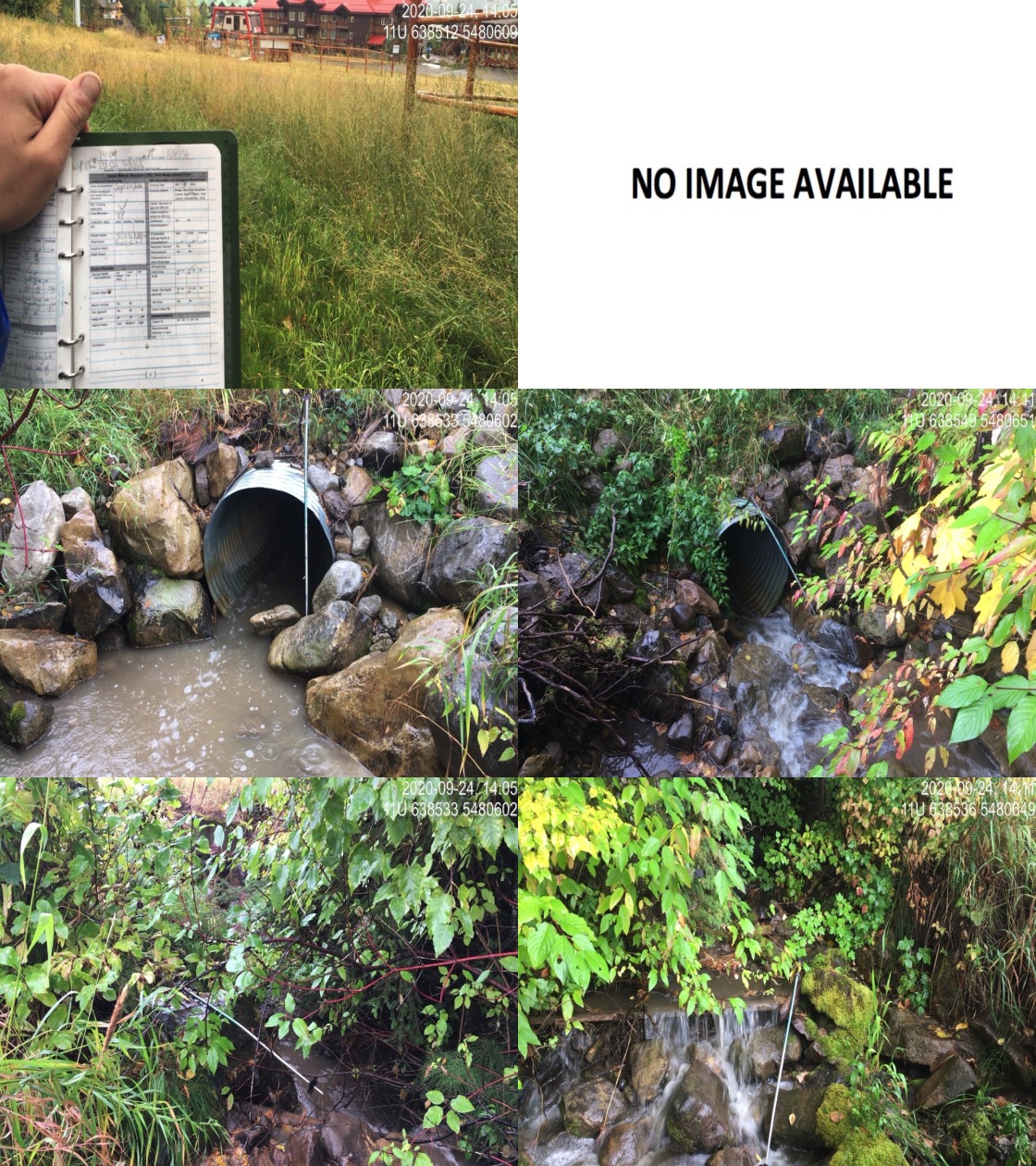
|
|||
| Comments: Stream gradient immediately upstream of crossing is near 20%. Crossing is last of a series within close proximity to each other. The crossing downstream of this one is near 100m long. Likely more crossings upstream on ski hill infrastructure and access roads. Recent heavy rains. |
| Location and Stream Data |
|
Crossing Characteristics | – |
|---|---|---|---|
| Date | 2020-09-23 | Crossing Sub Type | Round Culvert |
| PSCIS ID | 197572 | Diameter (m) | 1.5 |
| External ID | 4601594 | Length (m) | 22 |
| Crew | KP, AI | Embedded | No |
| UTM Zone | 11 | Depth Embedded (m) | – |
| Easting | 641090 | Resemble Channel | No |
| Northing | 5479392 | Backwatered | No |
| Stream | Tributary to Elk River | Percent Backwatered | – |
| Road | Railway | Fill Depth (m) | 2 |
| Road Tenure | Canadian Pacific | Outlet Drop (m) | 0 |
| Channel Width (m) | 2.7 | Outlet Pool Depth (m) | 0 |
| Stream Slope (%) | 2.5 | Inlet Drop | No |
| Beaver Activity | No | Slope (%) | 1.5 |
| Habitat Value | Low | Valley Fill | Deep Fill |
Photos: External ID 4601594. From top left clockwise: Road/Site Card, Barrel, Outlet, Downstream, Upstream, Inlet.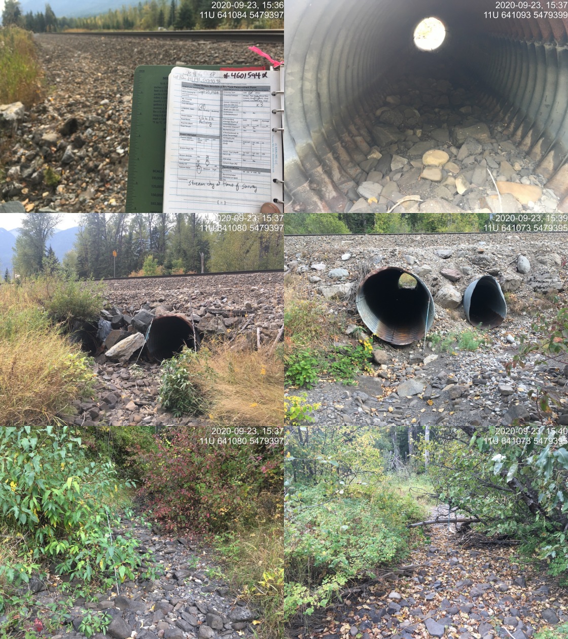
|
|||
| Comments: Stream dry at time of survey. 2 barrels (0.80 and 1.5m in diameter), similar heights but 1.5m slightly lower. Smaller barrel inlet damaged. |
| Location and Stream Data |
|
Crossing Characteristics | – |
|---|---|---|---|
| Date | 2020-09-24 | Crossing Sub Type | Round Culvert |
| PSCIS ID | 197576 | Diameter (m) | 1.2 |
| External ID | 4601639 | Length (m) | 99 |
| Crew | KP, AI | Embedded | No |
| UTM Zone | 11 | Depth Embedded (m) | – |
| Easting | 638630 | Resemble Channel | No |
| Northing | 5480655 | Backwatered | No |
| Stream | Tributary to Elk River | Percent Backwatered | – |
| Road | Fernie ski hill | Fill Depth (m) | 2.5 |
| Road Tenure | unclassified | Outlet Drop (m) | 0.73 |
| Channel Width (m) | 1.5 | Outlet Pool Depth (m) | 0.65 |
| Stream Slope (%) | 6 | Inlet Drop | Yes |
| Beaver Activity | No | Slope (%) | 11 |
| Habitat Value | Low | Valley Fill | Deep Fill |
Photos: External ID 4601639. From top left clockwise: Road/Site Card, Barrel, Outlet, Downstream, Upstream, Inlet.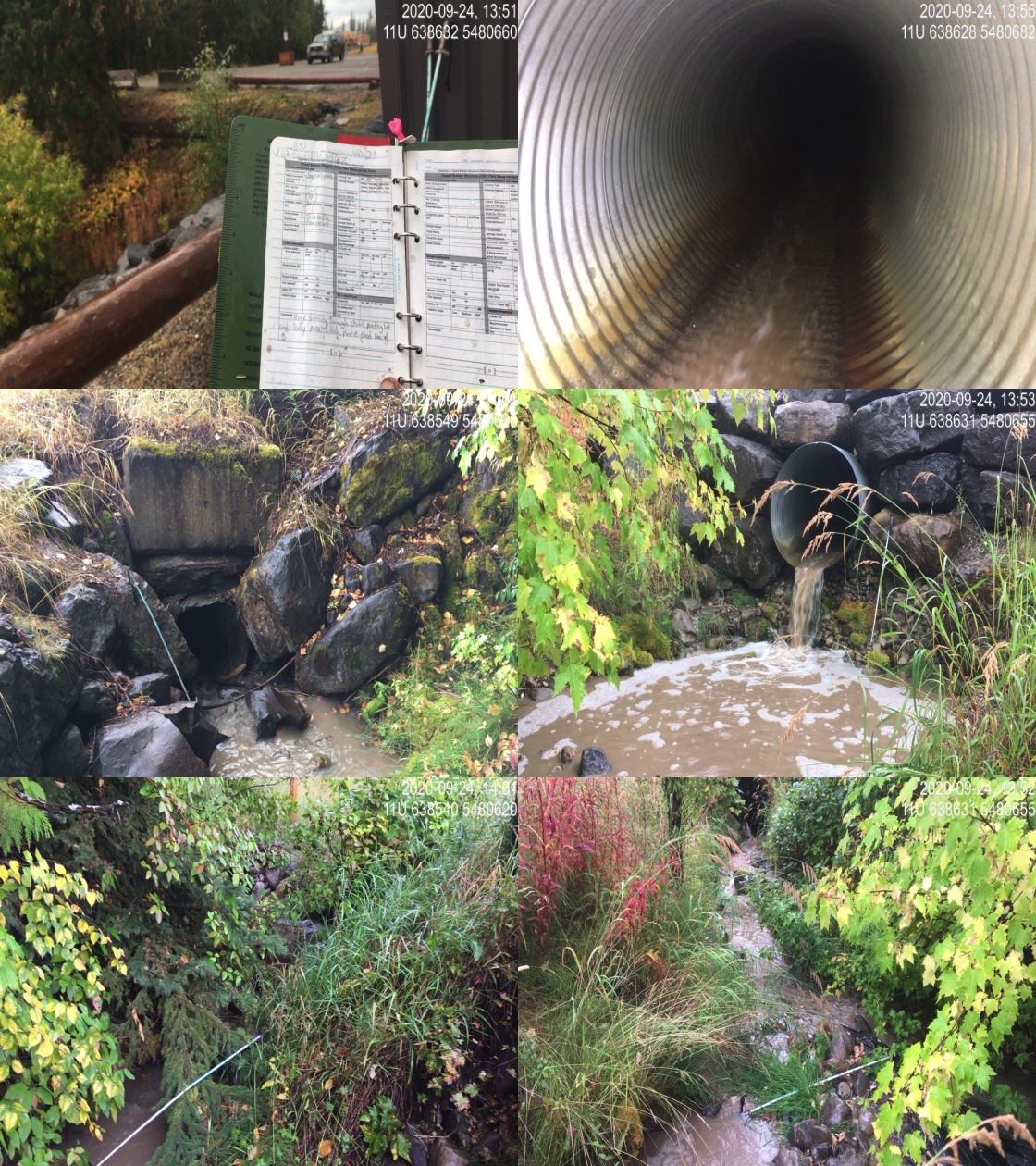
|
|||
| Comments: Huge crossing through the ski hill parking lot and lodge area. Largeoutlet drop and pool, extremely long culvert (close to 100m) tied in with other drainage infrastructure at the base of the Fernie ski hill. Inlet drop about .15m. |
| Location and Stream Data |
|
Crossing Characteristics | – |
|---|---|---|---|
| Date | 2020-09-20 | Crossing Sub Type | Round Culvert |
| PSCIS ID | 197565 | Diameter (m) | 0.9 |
| External ID | 4602270 | Length (m) | 14 |
| Crew | KP, AI | Embedded | No |
| UTM Zone | 11 | Depth Embedded (m) | – |
| Easting | 655441 | Resemble Channel | No |
| Northing | 5524175 | Backwatered | No |
| Stream | Tributary to Grave Creek | Percent Backwatered | – |
| Road | – | Fill Depth (m) | 2 |
| Road Tenure | unclassified | Outlet Drop (m) | 0 |
| Channel Width (m) | 1.5 | Outlet Pool Depth (m) | 0 |
| Stream Slope (%) | 3 | Inlet Drop | Yes |
| Beaver Activity | No | Slope (%) | 4 |
| Habitat Value | Low | Valley Fill | Deep Fill |
Photos: External ID 4602270. From top left clockwise: Road/Site Card, Barrel, Outlet, Downstream, Upstream, Inlet.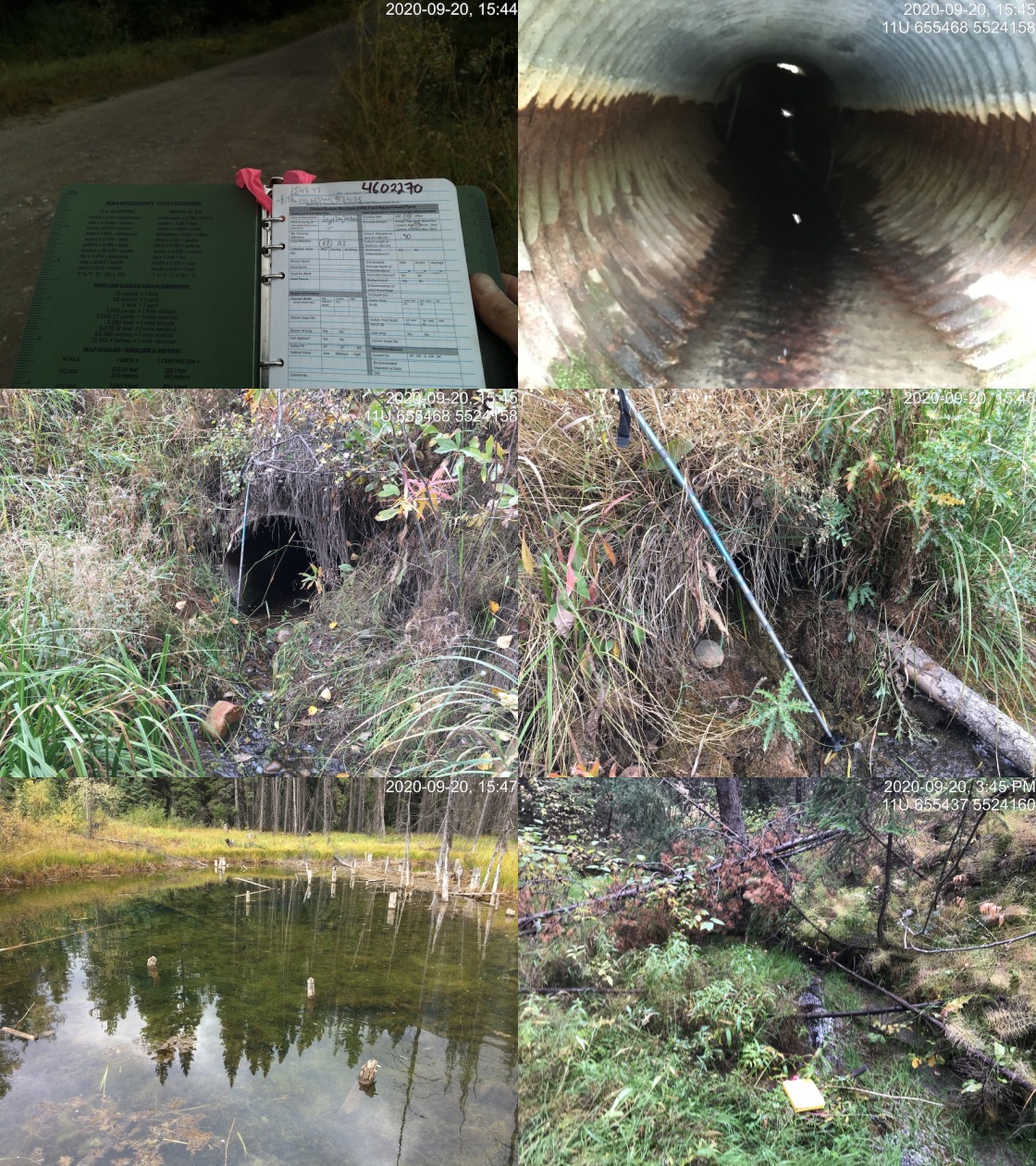
|
|||
| Comments: Inlet clogged with debris 3/4 of way up. Upstream area is wetland/pond. |
| Location and Stream Data |
|
Crossing Characteristics | – |
|---|---|---|---|
| Date | 2020-09-18 | Crossing Sub Type | Ford |
| PSCIS ID | 197536 | Diameter (m) | – |
| External ID | 4602276 | Length (m) | – |
| Crew | AI | Embedded | – |
| UTM Zone | 11 | Depth Embedded (m) | – |
| Easting | 649758 | Resemble Channel | – |
| Northing | 5527935 | Backwatered | – |
| Stream | Brule Creek | Percent Backwatered | – |
| Road | Spur | Fill Depth (m) | – |
| Road Tenure | unclassified | Outlet Drop (m) | – |
| Channel Width (m) | – | Outlet Pool Depth (m) | – |
| Stream Slope (%) | – | Inlet Drop | – |
| Beaver Activity | No | Slope (%) | – |
| Habitat Value | – | Valley Fill | – |
Photos: External ID 4602276. From top left clockwise: Road/Site Card, Barrel, Outlet, Downstream, Upstream, Inlet.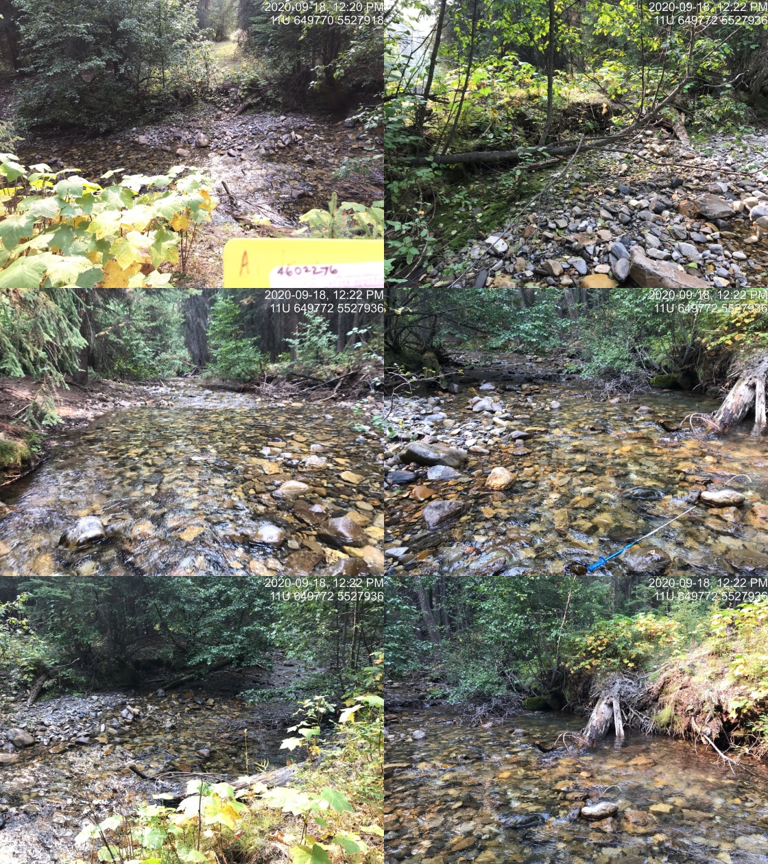
|
|||
| Comments: Deactivated. Ford. no issues. |
| Location and Stream Data |
|
Crossing Characteristics | – |
|---|---|---|---|
| Date | 2020-09-24 | Crossing Sub Type | Round Culvert |
| PSCIS ID | 197578 | Diameter (m) | 1.2 |
| External ID | 4602349 | Length (m) | 10 |
| Crew | KP, AI | Embedded | No |
| UTM Zone | 11 | Depth Embedded (m) | – |
| Easting | 638525 | Resemble Channel | No |
| Northing | 5481496 | Backwatered | Yes |
| Stream | Tributary to Elk River | Percent Backwatered | 20 |
| Road | Fernie Nordic Trail | Fill Depth (m) | 1.5 |
| Road Tenure | unclassified | Outlet Drop (m) | 0 |
| Channel Width (m) | 2 | Outlet Pool Depth (m) | 2 |
| Stream Slope (%) | 7 | Inlet Drop | No |
| Beaver Activity | No | Slope (%) | 3.5 |
| Habitat Value | Medium | Valley Fill | Deep Fill |
Photos: External ID 4602349. From top left clockwise: Road/Site Card, Barrel, Outlet, Downstream, Upstream, Inlet.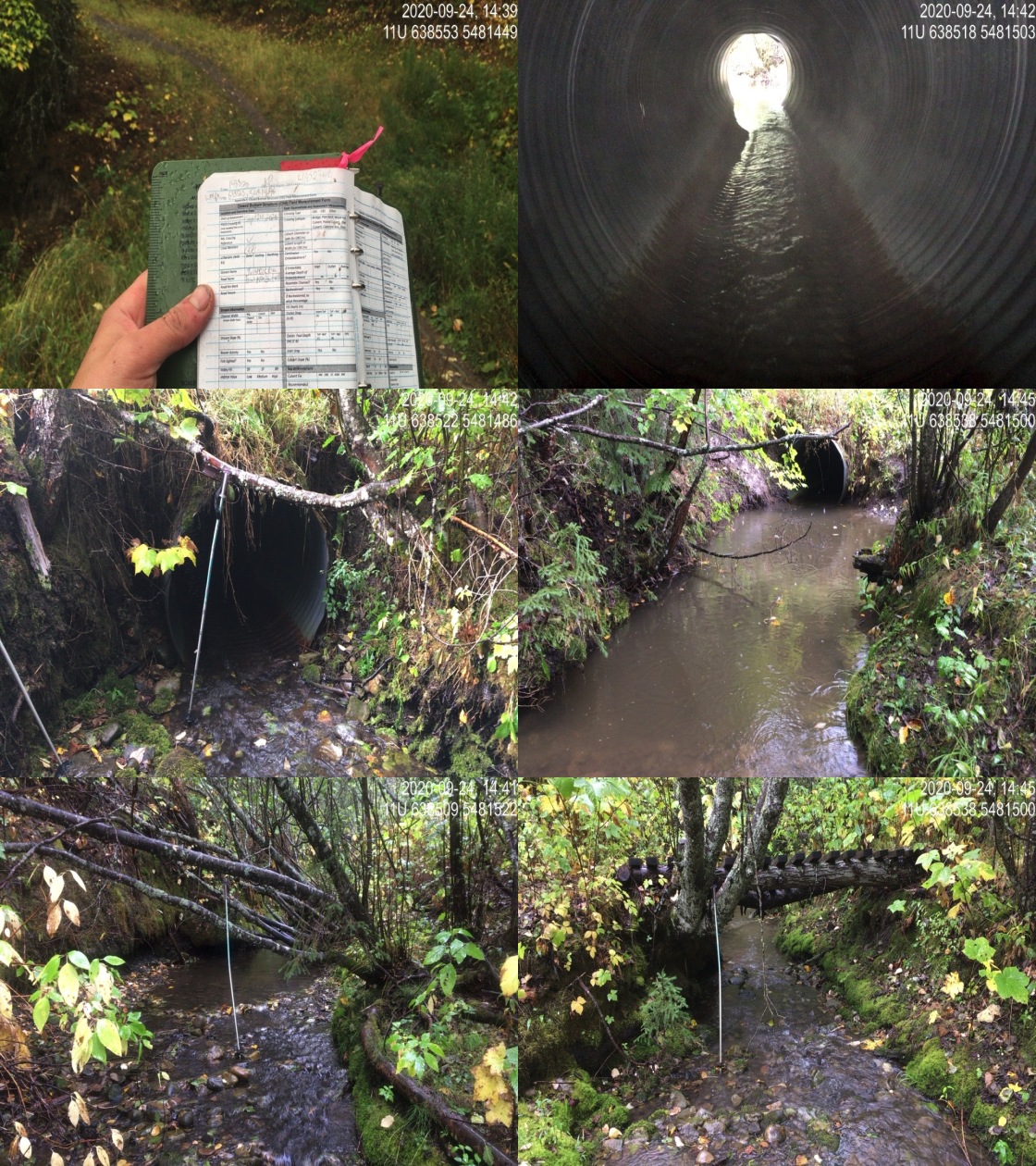
|
|||
| Comments: Outlet pool appears dredged, very deep, approximately 2m and 7-8m long. Nice stream, good flow. |
| Location and Stream Data |
|
Crossing Characteristics | – |
|---|---|---|---|
| Date | 2020-09-20 | Crossing Sub Type | Round Culvert |
| PSCIS ID | 197564 | Diameter (m) | 0.6 |
| External ID | 4602533 | Length (m) | 8 |
| Crew | KP, AI | Embedded | No |
| UTM Zone | 11 | Depth Embedded (m) | – |
| Easting | 661172 | Resemble Channel | No |
| Northing | 5524451 | Backwatered | No |
| Stream | Grave Creek | Percent Backwatered | – |
| Road | – | Fill Depth (m) | 0.35 |
| Road Tenure | unclassified | Outlet Drop (m) | 0 |
| Channel Width (m) | 0.1 | Outlet Pool Depth (m) | 0 |
| Stream Slope (%) | 1 | Inlet Drop | No |
| Beaver Activity | No | Slope (%) | 4 |
| Habitat Value | Low | Valley Fill | Deep Fill |
Photos: External ID 4602533. From top left clockwise: Road/Site Card, Barrel, Outlet, Downstream, Upstream, Inlet.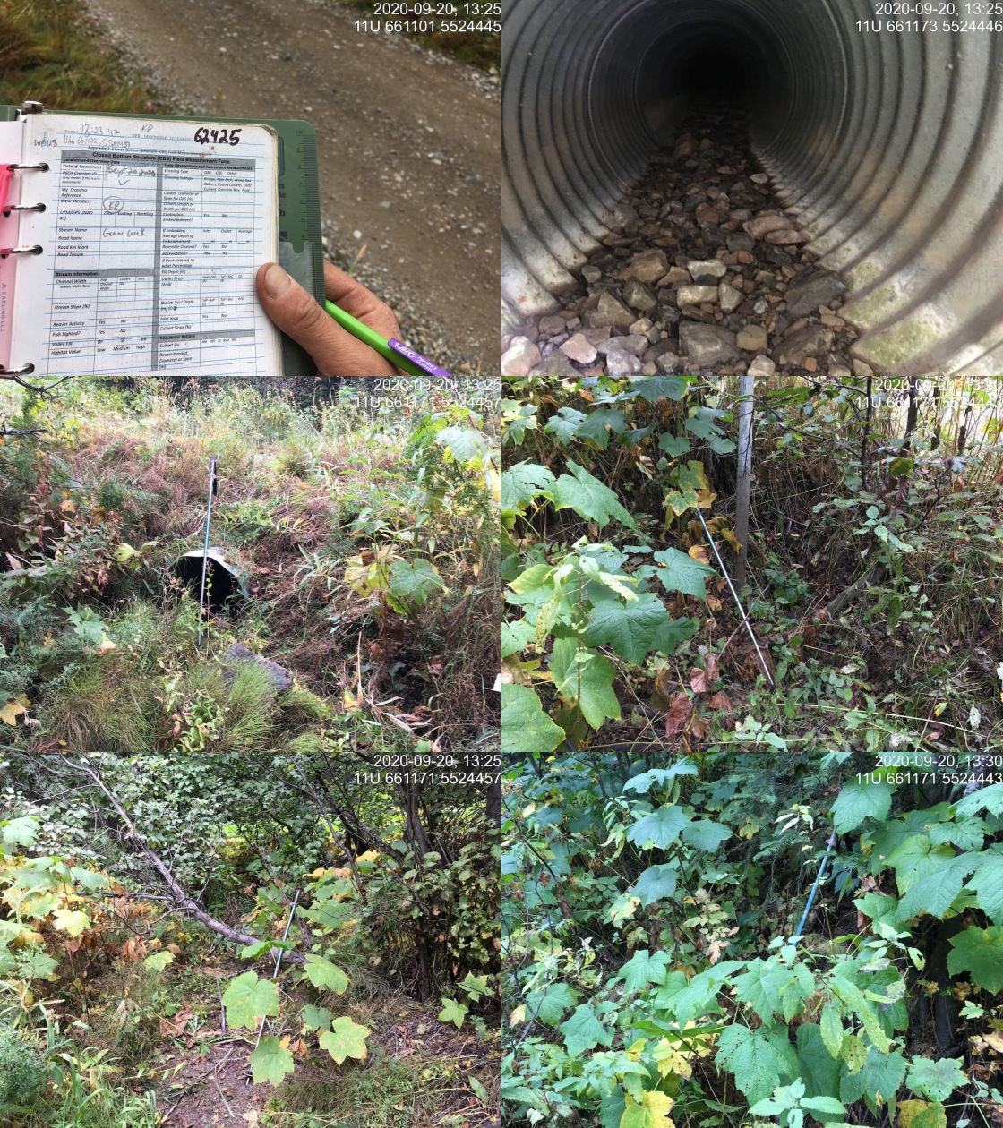
|
|||
| Comments: Stream dry at time of survey, channel not visible for about 40 downstream. Water and channel appear about 65m downstream of crossing. Upstream side of crossing inlet not visible, covered by road fill or deep organic debris. Channel upstream non-existent and dry. This system (labelled as Grave creek on the map) must be a side channel or remnant channel. |
| Location and Stream Data |
|
Crossing Characteristics | – |
|---|---|---|---|
| Date | 2020-09-23 | Crossing Sub Type | Round Culvert |
| PSCIS ID | 197547 | Diameter (m) | 0.6 |
| External ID | 4603265 | Length (m) | 13 |
| Crew | AI, KP | Embedded | No |
| UTM Zone | 11 | Depth Embedded (m) | – |
| Easting | 640287 | Resemble Channel | No |
| Northing | 5481650 | Backwatered | No |
| Stream | Tributary to Elk River | Percent Backwatered | – |
| Road | Railway | Fill Depth (m) | 3 |
| Road Tenure | Canadian Pacific | Outlet Drop (m) | 0 |
| Channel Width (m) | 0.5 | Outlet Pool Depth (m) | 0 |
| Stream Slope (%) | 0 | Inlet Drop | No |
| Beaver Activity | No | Slope (%) | 0.5 |
| Habitat Value | Low | Valley Fill | Deep Fill |
Photos: External ID 4603265. From top left clockwise: Road/Site Card, Barrel, Outlet, Downstream, Upstream, Inlet.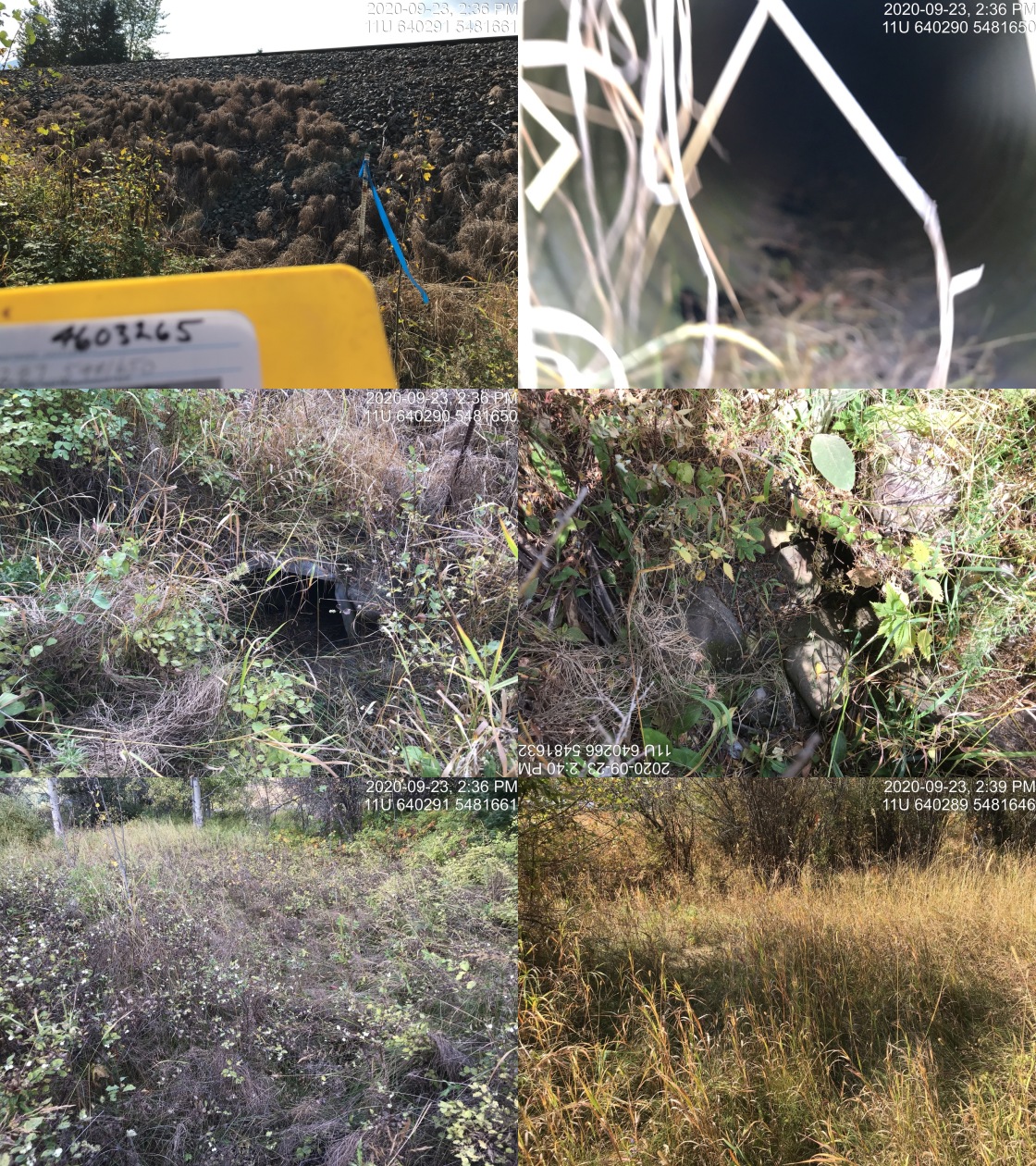
|
|||
| Comments: Dry vegetated channel. Not likely fish habitat. |
| Location and Stream Data |
|
Crossing Characteristics | – |
|---|---|---|---|
| Date | 2020-09-23 | Crossing Sub Type | Round Culvert |
| PSCIS ID | 197570 | Diameter (m) | 1.2 |
| External ID | 4603291 | Length (m) | 13 |
| Crew | KP, AI | Embedded | No |
| UTM Zone | 11 | Depth Embedded (m) | – |
| Easting | 640891 | Resemble Channel | No |
| Northing | 5480517 | Backwatered | No |
| Stream | Cokato Creek | Percent Backwatered | – |
| Road | Cokato Road | Fill Depth (m) | 0.5 |
| Road Tenure | MoTi local | Outlet Drop (m) | 0 |
| Channel Width (m) | 4.5 | Outlet Pool Depth (m) | 0 |
| Stream Slope (%) | 4 | Inlet Drop | No |
| Beaver Activity | No | Slope (%) | 4 |
| Habitat Value | Low | Valley Fill | Deep Fill |
Photos: External ID 4603291. From top left clockwise: Road/Site Card, Barrel, Outlet, Downstream, Upstream, Inlet.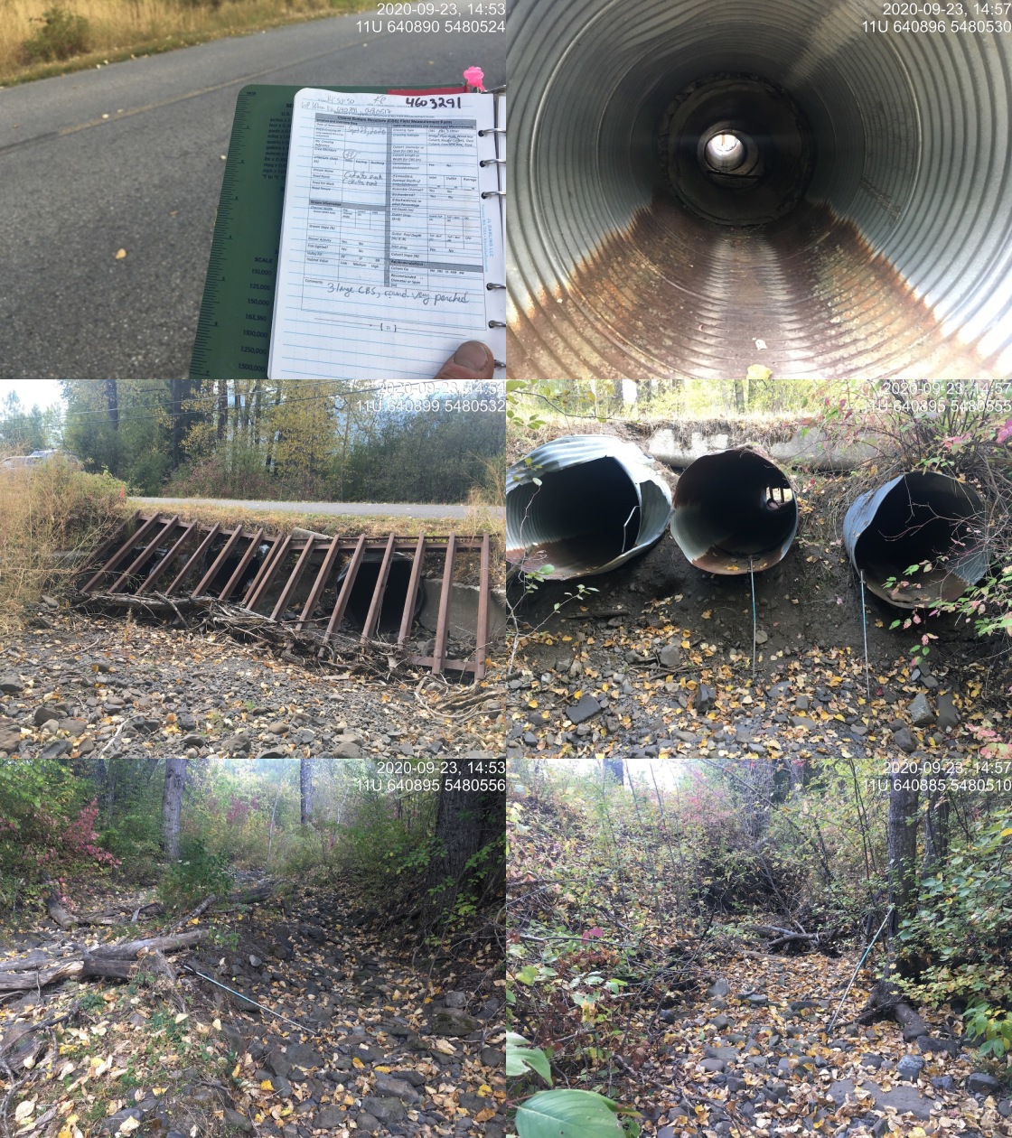
|
|||
| Comments: 3 large barrels (all 1.2m), very perched 0.7-1.3m above substrate. Stream dry at time of survey. Debris rack on upstream side of culvert. Note there is a slope change at the inlet of structure, much steeper short section possibly from damage. |
| Location and Stream Data |
|
Crossing Characteristics | – |
|---|---|---|---|
| Date | 2020-10-14 | Crossing Sub Type | Round Culvert |
| PSCIS ID | – | Diameter (m) | 0.95 |
| External ID | 4603294 | Length (m) | 11 |
| Crew | AI,MF | Embedded | No |
| UTM Zone | 11 | Depth Embedded (m) | – |
| Easting | 643191 | Resemble Channel | No |
| Northing | 5492547 | Backwatered | No |
| Stream | Tributary to Hartley Creek | Percent Backwatered | – |
| Road | Hartley Lake Rd | Fill Depth (m) | 1 |
| Road Tenure | – | Outlet Drop (m) | 0.5 |
| Channel Width (m) | 1.8 | Outlet Pool Depth (m) | 0 |
| Stream Slope (%) | 5.5 | Inlet Drop | Yes |
| Beaver Activity | No | Slope (%) | 4 |
| Habitat Value | Low | Valley Fill | Deep Fill |
Photos: External ID 4603294. From top left clockwise: Road/Site Card, Barrel, Outlet, Downstream, Upstream, Inlet.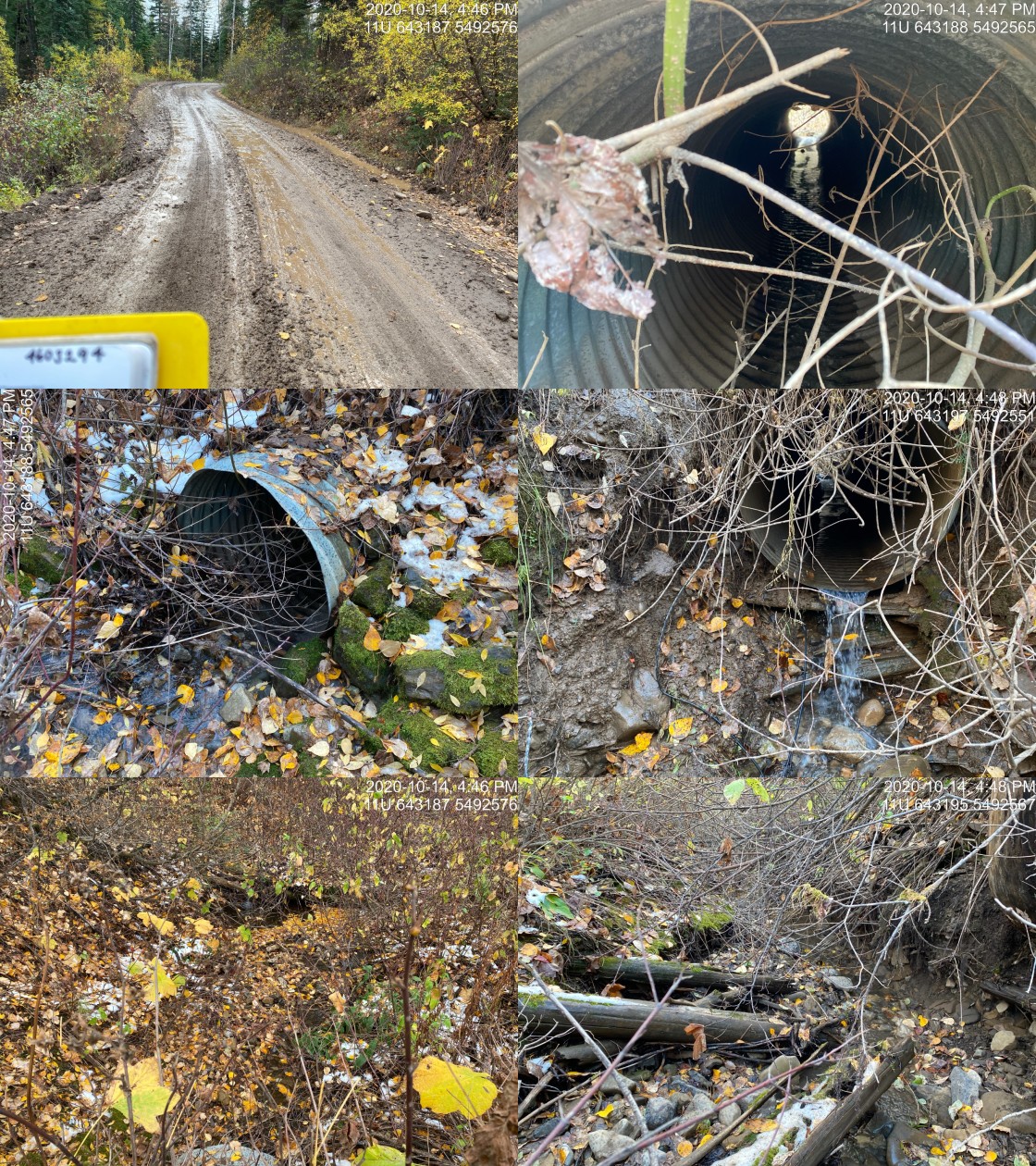
|
|||
| Comments: Small stream with some flow present. Some gravels. |
| Location and Stream Data |
|
Crossing Characteristics | – |
|---|---|---|---|
| Date | 2020-09-18 | Crossing Sub Type | Round Culvert |
| PSCIS ID | 197541 | Diameter (m) | 0.8 |
| External ID | 4604198 | Length (m) | 9 |
| Crew | AI, KP | Embedded | No |
| UTM Zone | 11 | Depth Embedded (m) | – |
| Easting | 647819 | Resemble Channel | No |
| Northing | 5498551 | Backwatered | No |
| Stream | Tributary to Elk River | Percent Backwatered | – |
| Road | Hadner FSR | Fill Depth (m) | 1 |
| Road Tenure | FLNR 6946 | Outlet Drop (m) | 0.6 |
| Channel Width (m) | 2.9 | Outlet Pool Depth (m) | 0.3 |
| Stream Slope (%) | 19 | Inlet Drop | Yes |
| Beaver Activity | No | Slope (%) | 6 |
| Habitat Value | Medium | Valley Fill | Deep Fill |
Photos: External ID 4604198. From top left clockwise: Road/Site Card, Barrel, Outlet, Downstream, Upstream, Inlet.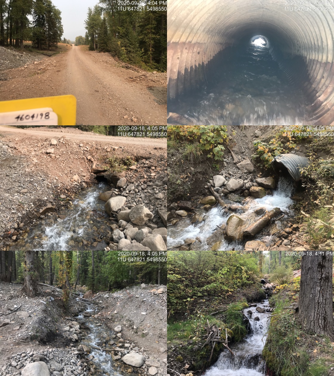
|
|||
| Comments: Steep stream with good flow. FISS sample site 2593 near crossing location. Suspect too steep to be fish bearing. |
| Location and Stream Data |
|
Crossing Characteristics | – |
|---|---|---|---|
| Date | 2020-09-24 | Crossing Sub Type | Round Culvert |
| PSCIS ID | 197575 | Diameter (m) | 0.9 |
| External ID | 4604455 | Length (m) | 16 |
| Crew | KP, AI | Embedded | No |
| UTM Zone | 11 | Depth Embedded (m) | – |
| Easting | 638669 | Resemble Channel | No |
| Northing | 5480601 | Backwatered | No |
| Stream | Tributary to Elk River | Percent Backwatered | – |
| Road | Fernie ski hill | Fill Depth (m) | 2 |
| Road Tenure | unclassified | Outlet Drop (m) | 0.15 |
| Channel Width (m) | 1.5 | Outlet Pool Depth (m) | 0.2 |
| Stream Slope (%) | 9 | Inlet Drop | Yes |
| Beaver Activity | No | Slope (%) | 7 |
| Habitat Value | Low | Valley Fill | Deep Fill |
Photos: External ID 4604455. From top left clockwise: Road/Site Card, Barrel, Outlet, Downstream, Upstream, Inlet.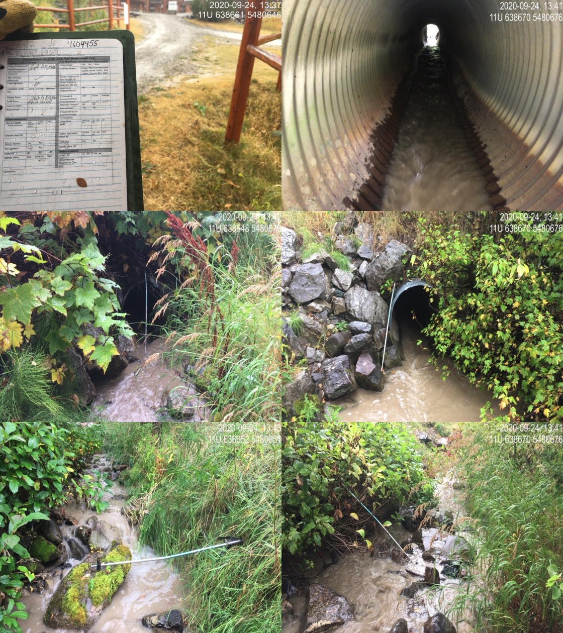
|
|||
| Comments: Inlet drop about .40m, significant and looks like increased barrier. Crossing is Fernie ski hill gravel road. urrently high and turbid due to heavy rain. |
| Location and Stream Data |
|
Crossing Characteristics | – |
|---|---|---|---|
| Date | 2020-09-16 | Crossing Sub Type | Pipe Arch |
| PSCIS ID | 197551 | Diameter (m) | 2.5 |
| External ID | 4605636 | Length (m) | 14 |
| Crew | KP, AI | Embedded | – |
| UTM Zone | 11 | Depth Embedded (m) | – |
| Easting | 644148 | Resemble Channel | – |
| Northing | 5564425 | Backwatered | – |
| Stream | Tributary to Elk River | Percent Backwatered | – |
| Road | Elk River FSR | Fill Depth (m) | – |
| Road Tenure | FLNR 0103 | Outlet Drop (m) | – |
| Channel Width (m) | – | Outlet Pool Depth (m) | – |
| Stream Slope (%) | – | Inlet Drop | – |
| Beaver Activity | No | Slope (%) | – |
| Habitat Value | – | Valley Fill | – |
Photos: External ID 4605636. From top left clockwise: Road/Site Card, Barrel, Outlet, Downstream, Upstream, Inlet.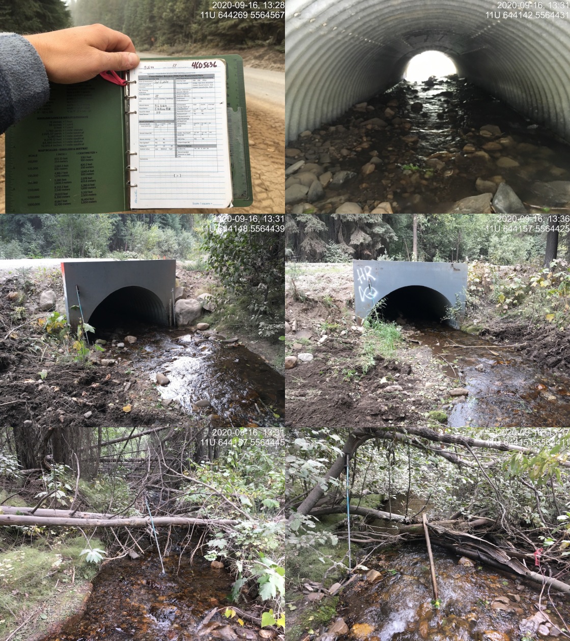
|
|||
| Comments: Appears passable. |
| Location and Stream Data |
|
Crossing Characteristics | – |
|---|---|---|---|
| Date | 2020-09-16 | Crossing Sub Type | Round Culvert |
| PSCIS ID | 197554 | Diameter (m) | 0.9 |
| External ID | 4605649 | Length (m) | 17 |
| Crew | KP, AI | Embedded | No |
| UTM Zone | 11 | Depth Embedded (m) | – |
| Easting | 645873 | Resemble Channel | No |
| Northing | 5556758 | Backwatered | Yes |
| Stream | Tributary to Elk River | Percent Backwatered | 100 |
| Road | Elk River FSR | Fill Depth (m) | 1.5 |
| Road Tenure | FLNR 0103 | Outlet Drop (m) | 0 |
| Channel Width (m) | 1 | Outlet Pool Depth (m) | 0.6 |
| Stream Slope (%) | 2.5 | Inlet Drop | No |
| Beaver Activity | No | Slope (%) | 0.5 |
| Habitat Value | Medium | Valley Fill | Deep Fill |
Photos: External ID 4605649. From top left clockwise: Road/Site Card, Barrel, Outlet, Downstream, Upstream, Inlet.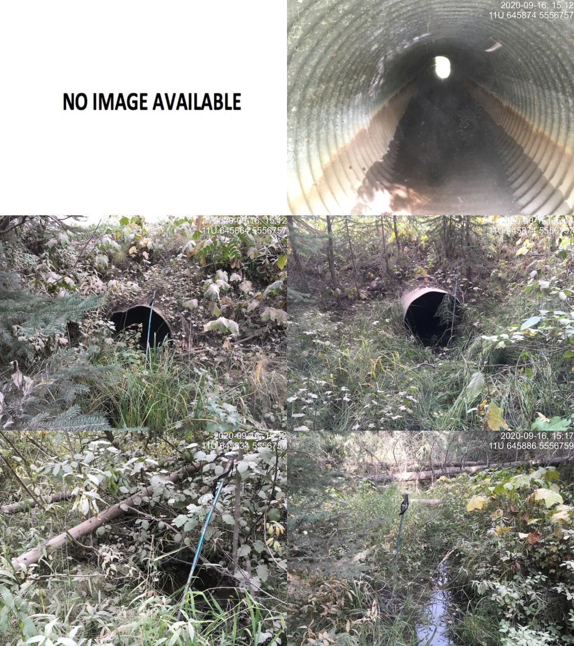
|
|||
| Comments: Low, slow flow. Culvert completely backwatered. |
| Location and Stream Data |
|
Crossing Characteristics | – |
|---|---|---|---|
| Date | 2020-09-16 | Crossing Sub Type | Round Culvert |
| PSCIS ID | 197520 | Diameter (m) | 0.9 |
| External ID | 4605653 | Length (m) | 11 |
| Crew | AI, KP | Embedded | No |
| UTM Zone | 11 | Depth Embedded (m) | – |
| Easting | 644666 | Resemble Channel | No |
| Northing | 5564940 | Backwatered | No |
| Stream | Tributary to Elk River | Percent Backwatered | – |
| Road | Elk River FSR | Fill Depth (m) | 0.4 |
| Road Tenure | FLNR 0103 | Outlet Drop (m) | 0 |
| Channel Width (m) | 2.5 | Outlet Pool Depth (m) | 0.2 |
| Stream Slope (%) | 2 | Inlet Drop | No |
| Beaver Activity | No | Slope (%) | 3.2 |
| Habitat Value | Medium | Valley Fill | Deep Fill |
Photos: External ID 4605653. From top left clockwise: Road/Site Card, Barrel, Outlet, Downstream, Upstream, Inlet.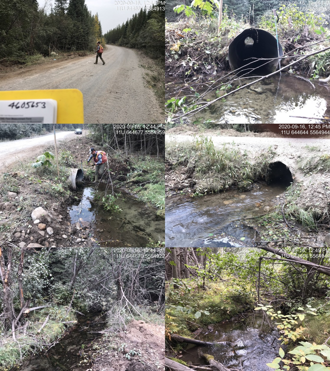
|
|||
| Comments: Good habitat, habitat assessment (FHAP) conducted in 2016 (Masse Environmental Consultants Ltd.) for proposed coal mine EA (Bingay). Electrofished U/S and D/S, see provincial records and data submission file at http://a100.gov.bc.ca/pub/acat/public/viewReport.do?reportId=52717 . Culvert does not appear to be barrier to any species at any life stage at time of survey. Could be barrier to small fish at high flows. EB and WCT recrded upstream. |
| Location and Stream Data |
|
Crossing Characteristics | – |
|---|---|---|---|
| Date | 2020-09-16 | Crossing Sub Type | Round Culvert |
| PSCIS ID | 197521 | Diameter (m) | 0.6 |
| External ID | 4605675 | Length (m) | 10 |
| Crew | AI, KP | Embedded | No |
| UTM Zone | 11 | Depth Embedded (m) | – |
| Easting | 645225 | Resemble Channel | No |
| Northing | 5567096 | Backwatered | No |
| Stream | Tributary to Elk River | Percent Backwatered | – |
| Road | Elk River FSR | Fill Depth (m) | 0.5 |
| Road Tenure | – | Outlet Drop (m) | 0 |
| Channel Width (m) | 2 | Outlet Pool Depth (m) | 0.05 |
| Stream Slope (%) | 0.5 | Inlet Drop | No |
| Beaver Activity | No | Slope (%) | 2.5 |
| Habitat Value | Medium | Valley Fill | Deep Fill |
Photos: External ID 4605675. From top left clockwise: Road/Site Card, Barrel, Outlet, Downstream, Upstream, Inlet.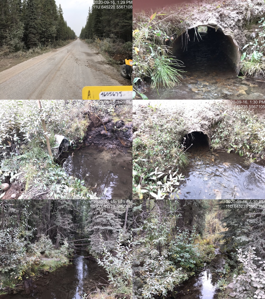
|
|||
| Comments: Culvert slope estimate. Stream dredged upstream to remove sediments. Flows are slow through culvert and unlikely barrier for fry/parr for much of year. Crossing 4606244 is on deactivated spur upstream so very likely a ford, about 300m upstream same thing for 4604099. |
| Location and Stream Data |
|
Crossing Characteristics | – |
|---|---|---|---|
| Date | 2020-09-16 | Crossing Sub Type | Round Culvert |
| PSCIS ID | 197527 | Diameter (m) | 1.5 |
| External ID | 4605697 | Length (m) | 2 |
| Crew | AI, KP | Embedded | No |
| UTM Zone | 11 | Depth Embedded (m) | – |
| Easting | 648722 | Resemble Channel | No |
| Northing | 5548198 | Backwatered | No |
| Stream | Crossing Creek | Percent Backwatered | – |
| Road | Elk River FSR | Fill Depth (m) | 1 |
| Road Tenure | FLNR 0103 | Outlet Drop (m) | 0 |
| Channel Width (m) | 2.5 | Outlet Pool Depth (m) | 0 |
| Stream Slope (%) | 3.5 | Inlet Drop | No |
| Beaver Activity | No | Slope (%) | 5 |
| Habitat Value | Low | Valley Fill | Deep Fill |
Photos: External ID 4605697. From top left clockwise: Road/Site Card, Barrel, Outlet, Downstream, Upstream, Inlet.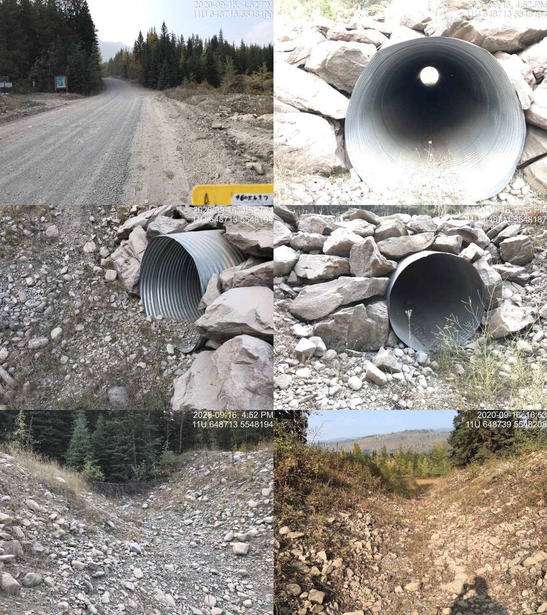
|
|||
| Comments: Dry channel at time of survey, channel transitions to grass flats about 60 meters downstream. |
| Location and Stream Data |
|
Crossing Characteristics | – |
|---|---|---|---|
| Date | 2020-09-16 | Crossing Sub Type | Round Culvert |
| PSCIS ID | 197522 | Diameter (m) | 0.35 |
| External ID | 4605705 | Length (m) | 15 |
| Crew | AI, KP | Embedded | No |
| UTM Zone | 11 | Depth Embedded (m) | – |
| Easting | 643733 | Resemble Channel | No |
| Northing | 5560586 | Backwatered | No |
| Stream | Tributary to Elk River | Percent Backwatered | – |
| Road | Elk River FSR | Fill Depth (m) | 1.2 |
| Road Tenure | Unknown | Outlet Drop (m) | 2.15 |
| Channel Width (m) | 1 | Outlet Pool Depth (m) | 0.4 |
| Stream Slope (%) | 0.5 | Inlet Drop | No |
| Beaver Activity | No | Slope (%) | 2.5 |
| Habitat Value | Low | Valley Fill | Deep Fill |
Photos: External ID 4605705. From top left clockwise: Road/Site Card, Barrel, Outlet, Downstream, Upstream, Inlet.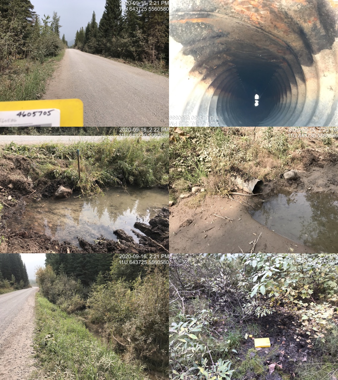
|
|||
| Comments: Stream not located where mapped. Unlikely fish bearing. Flows into forest floor downstream of culvert. |
| Location and Stream Data |
|
Crossing Characteristics | – |
|---|---|---|---|
| Date | 2020-09-16 | Crossing Sub Type | Round Culvert |
| PSCIS ID | 197552 | Diameter (m) | 0.6 |
| External ID | 4605707 | Length (m) | 11 |
| Crew | KP, AI | Embedded | No |
| UTM Zone | 11 | Depth Embedded (m) | – |
| Easting | 643981 | Resemble Channel | No |
| Northing | 5561132 | Backwatered | No |
| Stream | Tributary to Elk River | Percent Backwatered | – |
| Road | Elk River FSR | Fill Depth (m) | 0.4 |
| Road Tenure | FLNR 0103 | Outlet Drop (m) | 0 |
| Channel Width (m) | 2.3 | Outlet Pool Depth (m) | 0 |
| Stream Slope (%) | 1 | Inlet Drop | No |
| Beaver Activity | No | Slope (%) | 1.5 |
| Habitat Value | Low | Valley Fill | Deep Fill |
Photos: External ID 4605707. From top left clockwise: Road/Site Card, Barrel, Outlet, Downstream, Upstream, Inlet.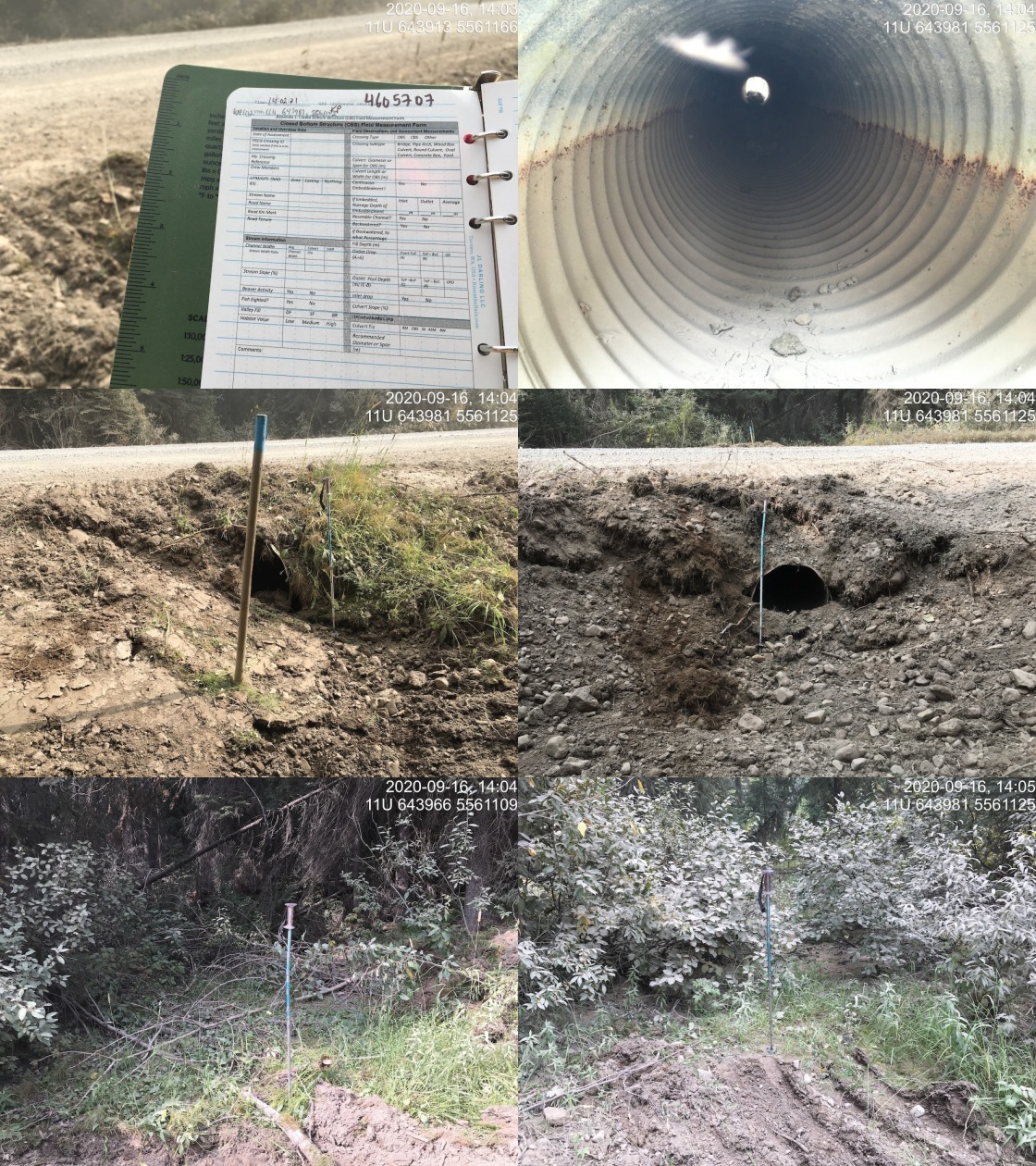
|
|||
| Comments: Stream dry at time of survey. Vegetated channel, loaded with sediment. Inlet of culvert damaged, partly bent. Inlet and outlet area dredged. Not likely fish habitat. |
| Location and Stream Data |
|
Crossing Characteristics | – |
|---|---|---|---|
| Date | 2020-09-16 | Crossing Sub Type | Round Culvert |
| PSCIS ID | 197523 | Diameter (m) | 0.6 |
| External ID | 4605708 | Length (m) | 10 |
| Crew | AI, KP | Embedded | Yes |
| UTM Zone | 11 | Depth Embedded (m) | 0.1 |
| Easting | 643611 | Resemble Channel | Yes |
| Northing | 5559835 | Backwatered | No |
| Stream | Tributary to Lowe Creek | Percent Backwatered | – |
| Road | Elk River FSR | Fill Depth (m) | 0.5 |
| Road Tenure | FLNR 0103 | Outlet Drop (m) | 0 |
| Channel Width (m) | 1.1 | Outlet Pool Depth (m) | 0 |
| Stream Slope (%) | 3.5 | Inlet Drop | No |
| Beaver Activity | No | Slope (%) | 1.5 |
| Habitat Value | Low | Valley Fill | Deep Fill |
Photos: External ID 4605708. From top left clockwise: Road/Site Card, Barrel, Outlet, Downstream, Upstream, Inlet.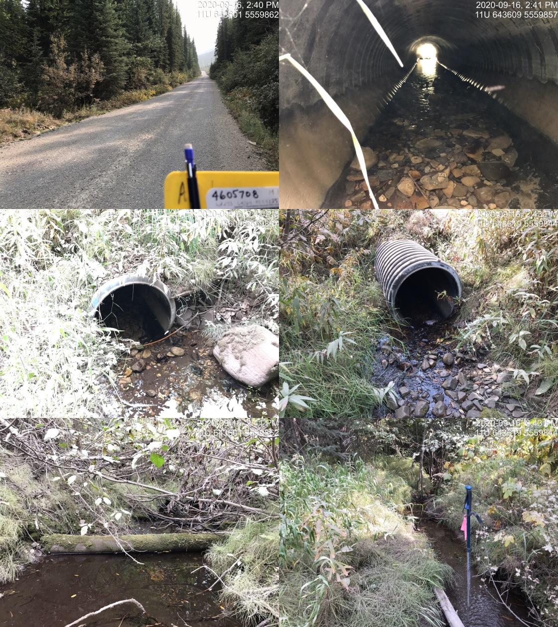
|
|||
| Comments: Channelized downstream due to dredging for about 30m. Small stream, substrate primarily fines but some gravel present. |
| Location and Stream Data |
|
Crossing Characteristics | – |
|---|---|---|---|
| Date | 2020-09-16 | Crossing Sub Type | Round Culvert |
| PSCIS ID | 197555 | Diameter (m) | 1.5 |
| External ID | 4605732 | Length (m) | 49 |
| Crew | KP, AI | Embedded | No |
| UTM Zone | 11 | Depth Embedded (m) | – |
| Easting | 646735 | Resemble Channel | No |
| Northing | 5554534 | Backwatered | No |
| Stream | Tributary to Elk River | Percent Backwatered | – |
| Road | Elk River FSR | Fill Depth (m) | 8 |
| Road Tenure | FLNR 0103 | Outlet Drop (m) | 1.48 |
| Channel Width (m) | 3.5 | Outlet Pool Depth (m) | 1.3 |
| Stream Slope (%) | 1.5 | Inlet Drop | Yes |
| Beaver Activity | No | Slope (%) | 3.5 |
| Habitat Value | High | Valley Fill | Deep Fill |
Photos: External ID 4605732. From top left clockwise: Road/Site Card, Barrel, Outlet, Downstream, Upstream, Inlet.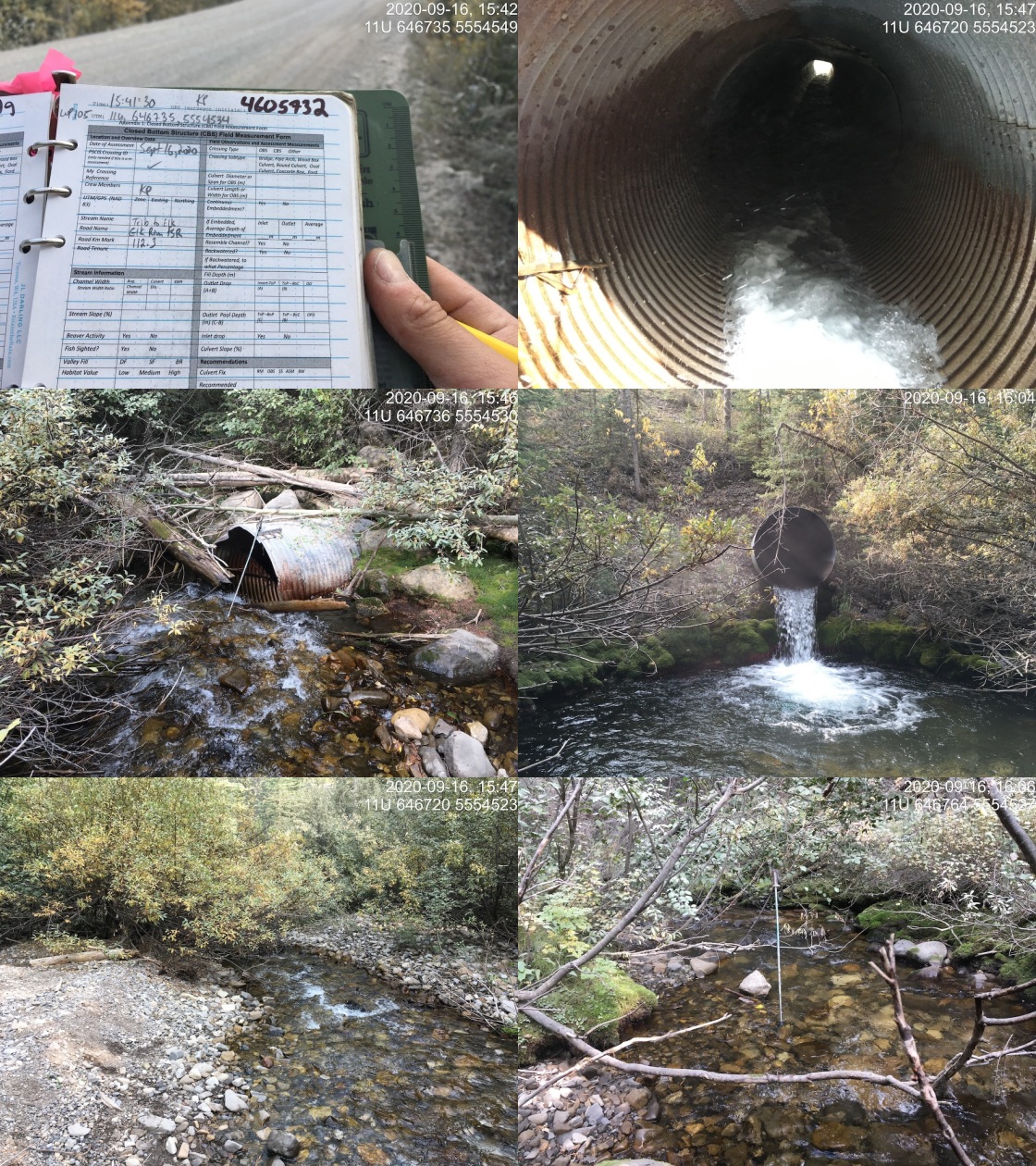
|
|||
| Comments: Large perched culvert. High value habitat. Habitat confirmation and sampling conducted. |
| Location and Stream Data |
|
Crossing Characteristics | – |
|---|---|---|---|
| Date | 2020-09-16 | Crossing Sub Type | Round Culvert |
| PSCIS ID | 197526 | Diameter (m) | 1.2 |
| External ID | 4605733 | Length (m) | 10 |
| Crew | AI, KP | Embedded | No |
| UTM Zone | 11 | Depth Embedded (m) | – |
| Easting | 647191 | Resemble Channel | No |
| Northing | 5552693 | Backwatered | No |
| Stream | Tributary to Elk River | Percent Backwatered | – |
| Road | Elk River FSR | Fill Depth (m) | 1 |
| Road Tenure | FLNR 0103 | Outlet Drop (m) | 0.3 |
| Channel Width (m) | 3.1 | Outlet Pool Depth (m) | 0.6 |
| Stream Slope (%) | 2 | Inlet Drop | No |
| Beaver Activity | No | Slope (%) | 1 |
| Habitat Value | Low | Valley Fill | Deep Fill |
Photos: External ID 4605733. From top left clockwise: Road/Site Card, Barrel, Outlet, Downstream, Upstream, Inlet.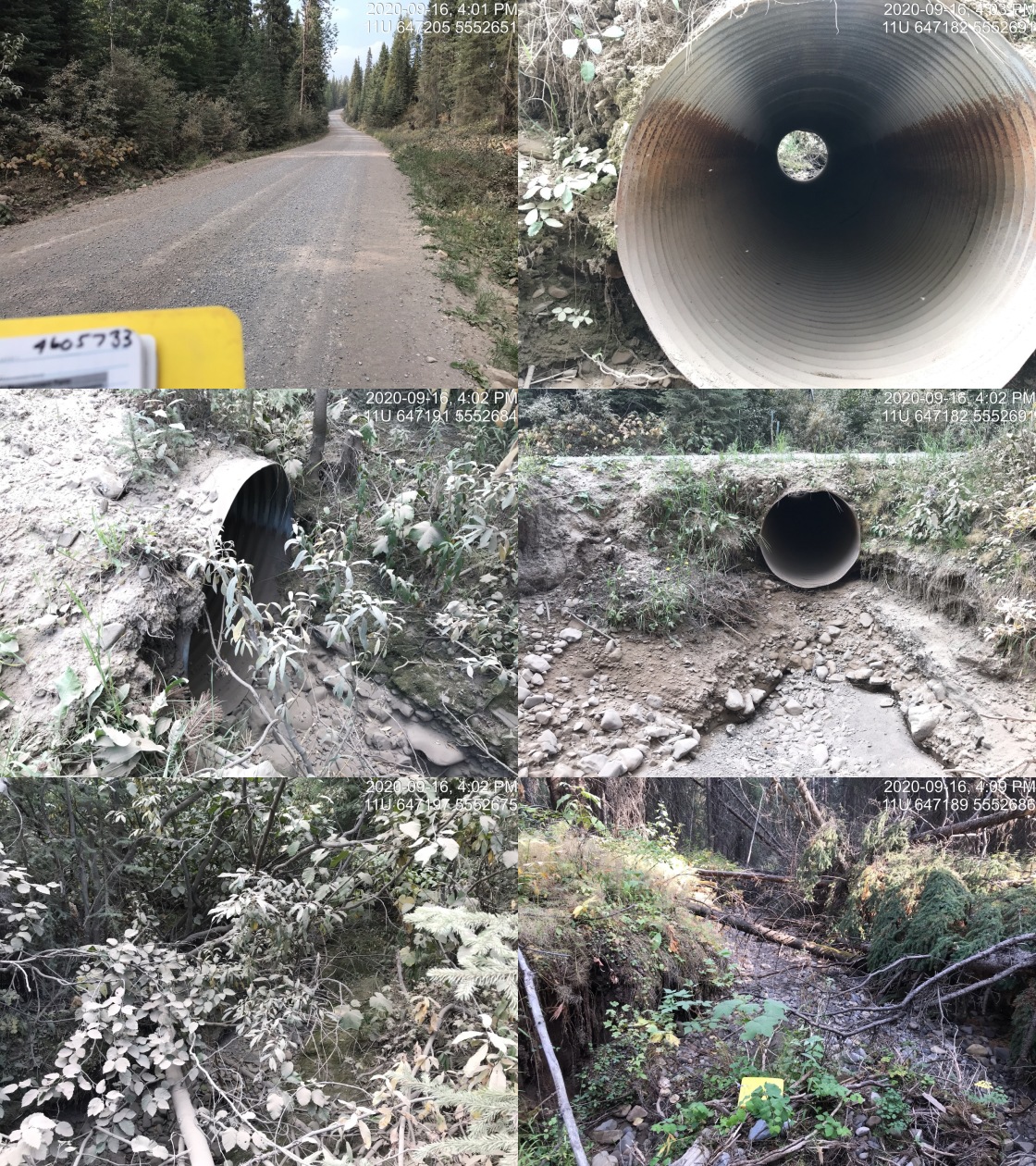
|
|||
| Comments: Freshly dredged. Dry, Dredging may extend well down channel. See photo from about 130m downstream. |
| Location and Stream Data |
|
Crossing Characteristics | – |
|---|---|---|---|
| Date | 2020-09-16 | Crossing Sub Type | Round Culvert |
| PSCIS ID | 197553 | Diameter (m) | 1.5 |
| External ID | 4605742 | Length (m) | 15 |
| Crew | KP, AI | Embedded | Yes |
| UTM Zone | 11 | Depth Embedded (m) | 0.12 |
| Easting | 643578 | Resemble Channel | Yes |
| Northing | 5560087 | Backwatered | No |
| Stream | Lowe Creek | Percent Backwatered | – |
| Road | Elk River FSR | Fill Depth (m) | 0.3 |
| Road Tenure | FLNR 0103 | Outlet Drop (m) | 0 |
| Channel Width (m) | 2.5 | Outlet Pool Depth (m) | 0.2 |
| Stream Slope (%) | 3.5 | Inlet Drop | No |
| Beaver Activity | No | Slope (%) | 1.5 |
| Habitat Value | High | Valley Fill | Deep Fill |
Photos: External ID 4605742. From top left clockwise: Road/Site Card, Barrel, Outlet, Downstream, Upstream, Inlet.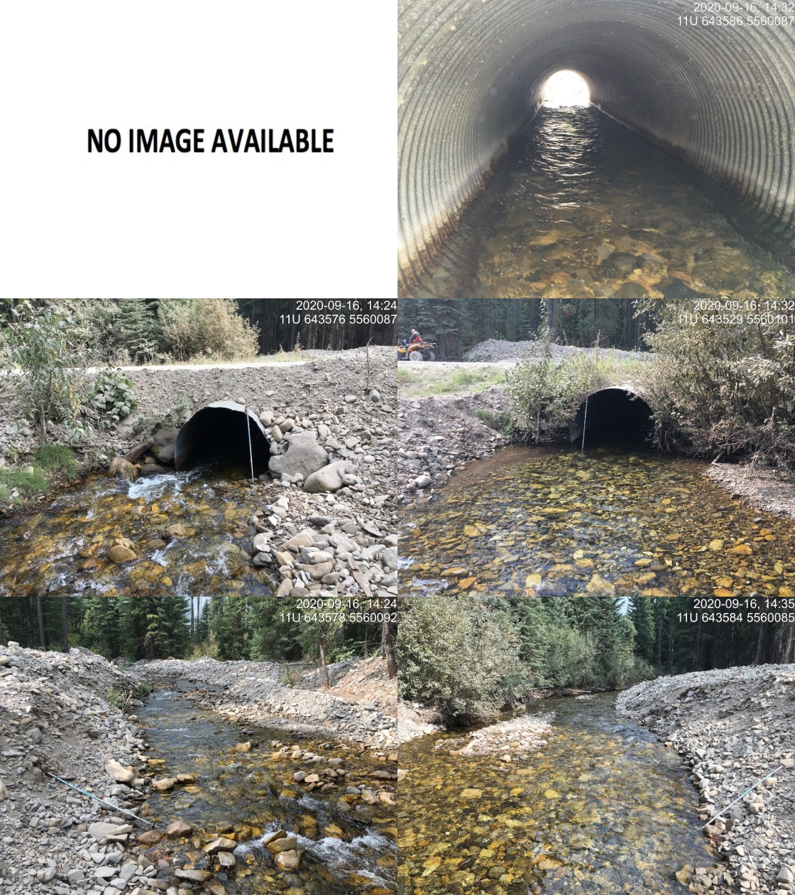
|
|||
| Comments: Upstream past dredging natural channel 2.5m wide. Downstream below dredging extremely braided, original channel difficult to track. Channel widths >10m at times with substrate on top of banks and in bases of trees. Channel dredged upstream and downstream approximately 75m on each. Habitat assessment (FHAP) conducted in 2016 (Masse Environmental Consultants Ltd.) for proposed coal mine EA (Bingay). Electrofished D/S, see provincial records and data submission file at http://a100.gov.bc.ca/pub/acat/public/viewReport.do?reportId=52717 . |
| Location and Stream Data |
|
Crossing Characteristics | – |
|---|---|---|---|
| Date | 2020-10-17 | Crossing Sub Type | Ford |
| PSCIS ID | – | Diameter (m) | – |
| External ID | 4606006 | Length (m) | – |
| Crew | AI, MF | Embedded | – |
| UTM Zone | 11 | Depth Embedded (m) | – |
| Easting | 649094 | Resemble Channel | – |
| Northing | 5531756 | Backwatered | – |
| Stream | Weigert Creek | Percent Backwatered | – |
| Road | Weigert FSR | Fill Depth (m) | – |
| Road Tenure | – | Outlet Drop (m) | – |
| Channel Width (m) | – | Outlet Pool Depth (m) | – |
| Stream Slope (%) | – | Inlet Drop | – |
| Beaver Activity | No | Slope (%) | – |
| Habitat Value | – | Valley Fill | – |
Photos: External ID 4606006. From top left clockwise: Road/Site Card, Barrel, Outlet, Downstream, Upstream, Inlet.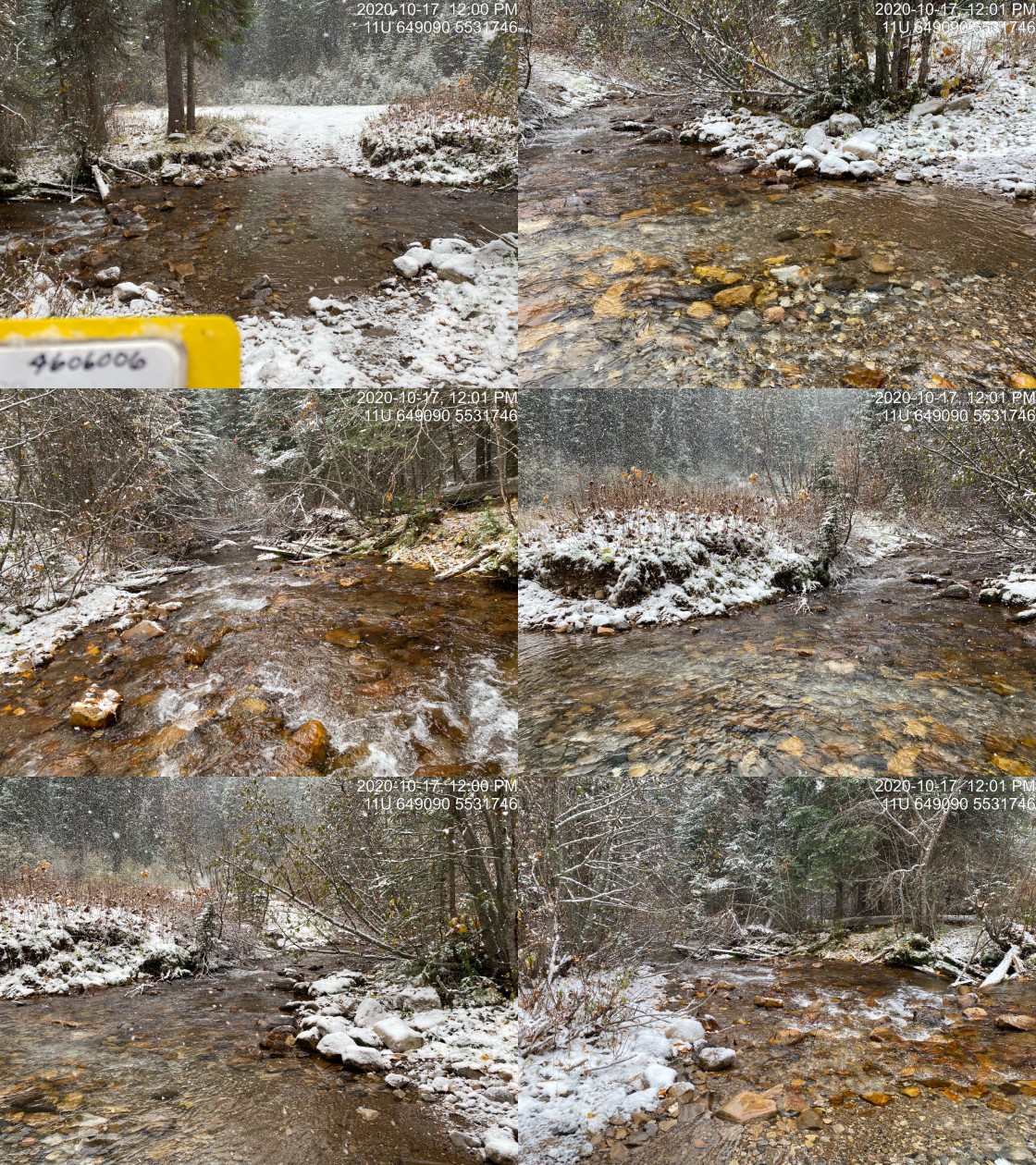
|
|||
| Comments: Ford passable with 4wd. |
| Location and Stream Data |
|
Crossing Characteristics | – |
|---|---|---|---|
| Date | 2020-10-14 | Crossing Sub Type | Round Culvert |
| PSCIS ID | – | Diameter (m) | 1.7 |
| External ID | 4606515 | Length (m) | 9 |
| Crew | AI, MF | Embedded | No |
| UTM Zone | 11 | Depth Embedded (m) | – |
| Easting | 642385 | Resemble Channel | No |
| Northing | 5493830 | Backwatered | No |
| Stream | Tributary to Hartley Creek | Percent Backwatered | – |
| Road | Hartley Lake Rd | Fill Depth (m) | 0.3 |
| Road Tenure | – | Outlet Drop (m) | 0 |
| Channel Width (m) | 6.7 | Outlet Pool Depth (m) | 0 |
| Stream Slope (%) | 11 | Inlet Drop | No |
| Beaver Activity | No | Slope (%) | 14 |
| Habitat Value | Low | Valley Fill | Deep Fill |
Photos: External ID 4606515. From top left clockwise: Road/Site Card, Barrel, Outlet, Downstream, Upstream, Inlet.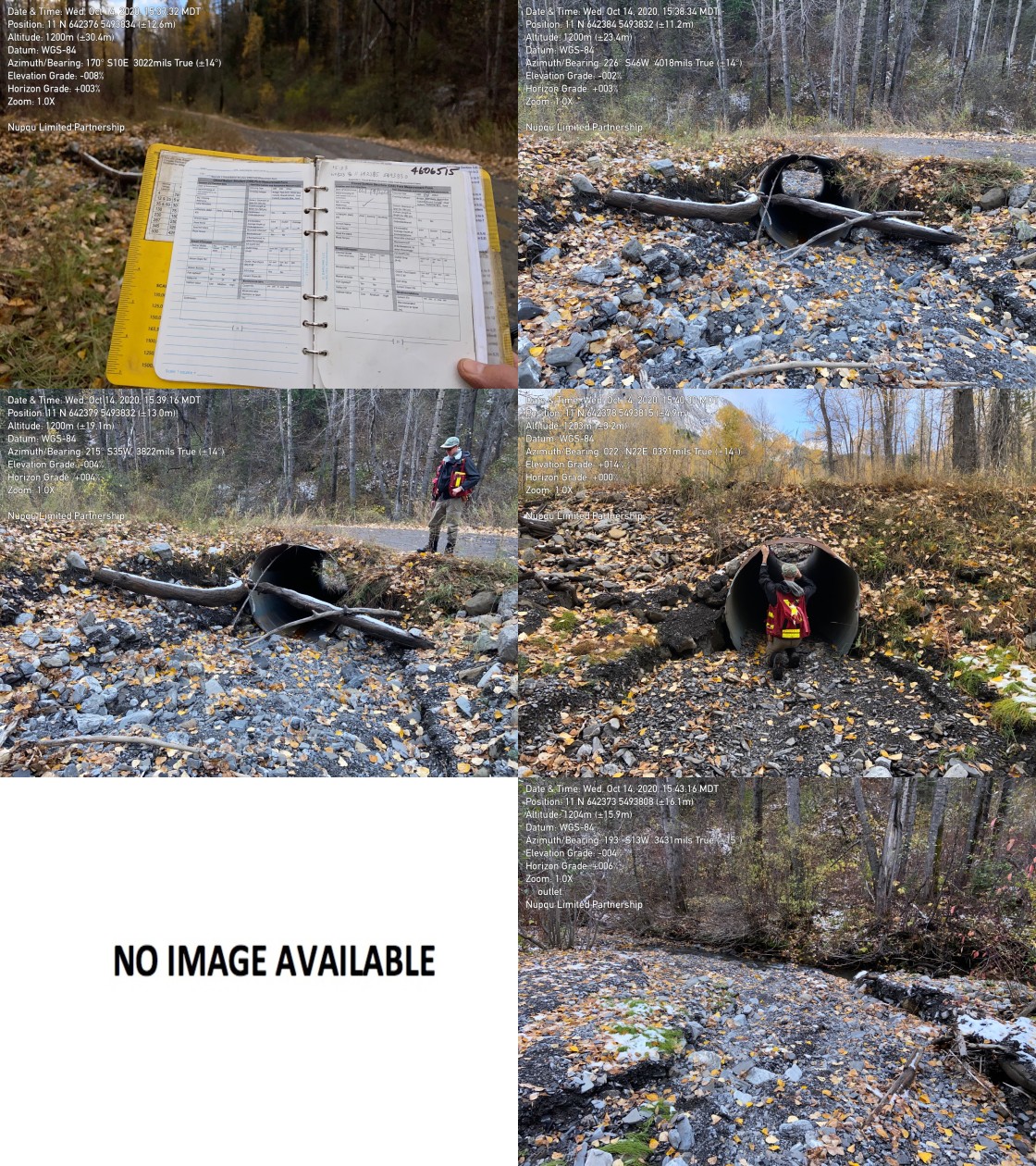
|
|||
| Comments: Dry at time of survey. Appears to be dredged. |
| Location and Stream Data |
|
Crossing Characteristics | – |
|---|---|---|---|
| Date | 2020-10-14 | Crossing Sub Type | Bridge |
| PSCIS ID | – | Diameter (m) | 4.8 |
| External ID | 4606518 | Length (m) | 12 |
| Crew | MF, AI | Embedded | – |
| UTM Zone | 11 | Depth Embedded (m) | – |
| Easting | 642606 | Resemble Channel | – |
| Northing | 5493561 | Backwatered | – |
| Stream | Tributary to Hartley Creek | Percent Backwatered | – |
| Road | Hartley Lake Rd | Fill Depth (m) | – |
| Road Tenure | – | Outlet Drop (m) | – |
| Channel Width (m) | – | Outlet Pool Depth (m) | – |
| Stream Slope (%) | – | Inlet Drop | – |
| Beaver Activity | No | Slope (%) | – |
| Habitat Value | – | Valley Fill | – |
Photos: External ID 4606518. From top left clockwise: Road/Site Card, Barrel, Outlet, Downstream, Upstream, Inlet.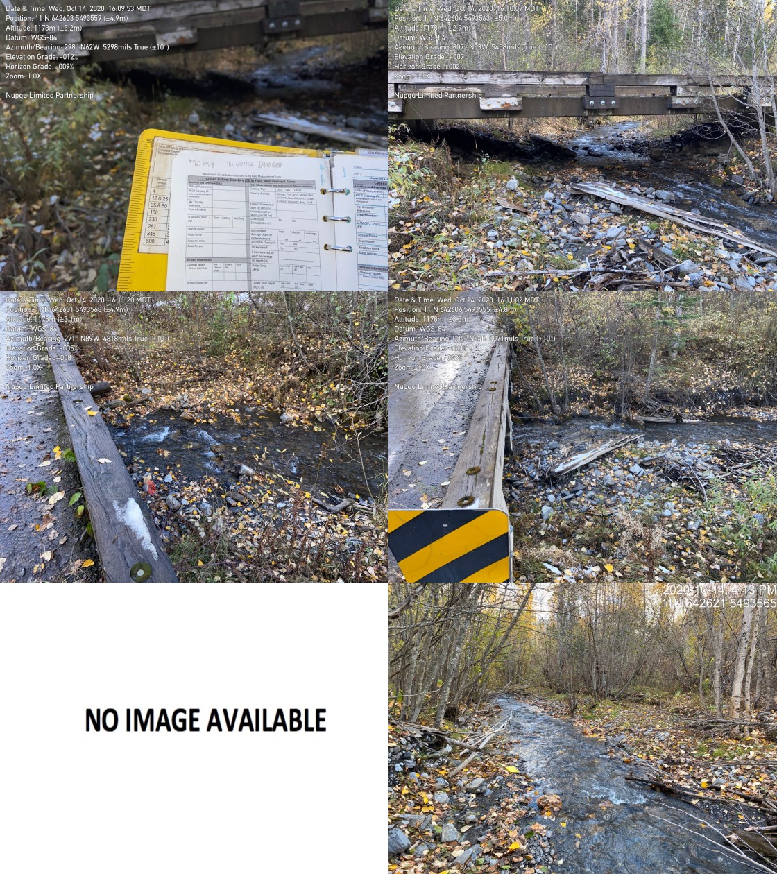
|
|||
| Comments: Channel width 3.6. Gravel substrate with cobbles. |
| Location and Stream Data |
|
Crossing Characteristics | – |
|---|---|---|---|
| Date | 2020-09-16 | Crossing Sub Type | Round Culvert |
| PSCIS ID | 197525 | Diameter (m) | 0.4 |
| External ID | 4606669 | Length (m) | 10 |
| Crew | AI, KP | Embedded | No |
| UTM Zone | 11 | Depth Embedded (m) | – |
| Easting | 646462 | Resemble Channel | No |
| Northing | 5554360 | Backwatered | No |
| Stream | Tributary to Elk River | Percent Backwatered | – |
| Road | Spur | Fill Depth (m) | 1 |
| Road Tenure | Canfor R08473 | Outlet Drop (m) | 0 |
| Channel Width (m) | 1 | Outlet Pool Depth (m) | 0 |
| Stream Slope (%) | 0.5 | Inlet Drop | No |
| Beaver Activity | No | Slope (%) | 2 |
| Habitat Value | Low | Valley Fill | Deep Fill |
Photos: External ID 4606669. From top left clockwise: Road/Site Card, Barrel, Outlet, Downstream, Upstream, Inlet.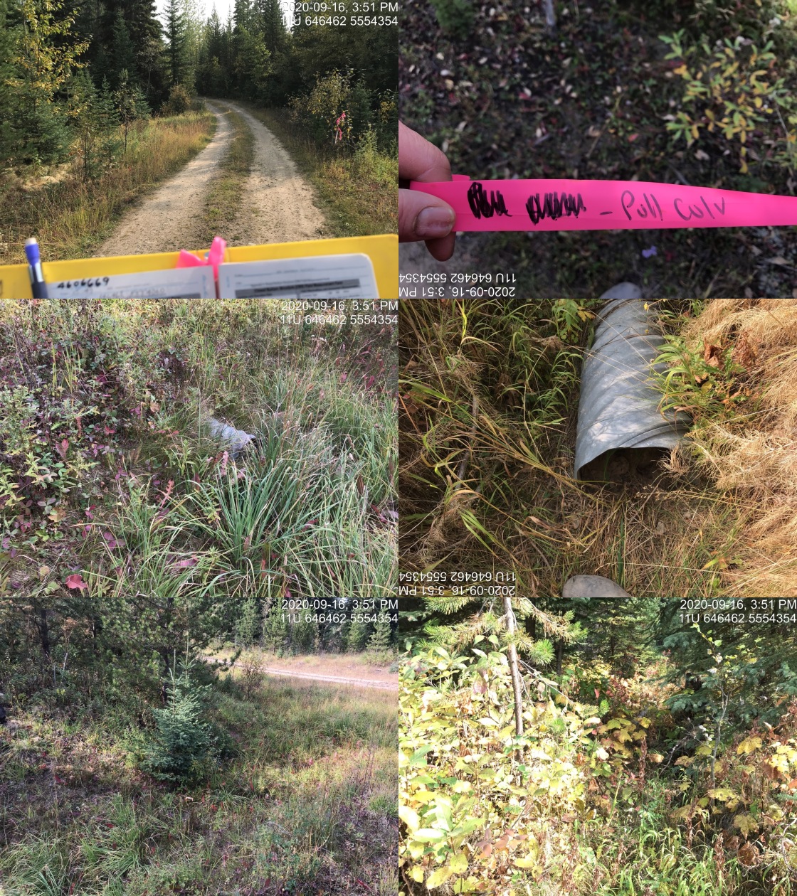
|
|||
| Comments: Plan in place to deactivate entire network here (personal communication with local machinery operator). Dry, vegetated channel. Likely non-fish bearing. |
| Location and Stream Data |
|
Crossing Characteristics | – |
|---|---|---|---|
| Date | 2020-09-23 | Crossing Sub Type | Concrete Box |
| PSCIS ID | 197568 | Diameter (m) | 1.2 |
| External ID | 4606807 | Length (m) | 9 |
| Crew | KP, AI | Embedded | Yes |
| UTM Zone | 11 | Depth Embedded (m) | 0.09 |
| Easting | 639952 | Resemble Channel | No |
| Northing | 5483636 | Backwatered | No |
| Stream | Tributary to Elk River | Percent Backwatered | – |
| Road | Railway | Fill Depth (m) | 6 |
| Road Tenure | Canadian Pacific | Outlet Drop (m) | 0 |
| Channel Width (m) | 1.5 | Outlet Pool Depth (m) | 0 |
| Stream Slope (%) | 30 | Inlet Drop | No |
| Beaver Activity | No | Slope (%) | 1.5 |
| Habitat Value | Low | Valley Fill | Deep Fill |
Photos: External ID 4606807. From top left clockwise: Road/Site Card, Barrel, Outlet, Downstream, Upstream, Inlet.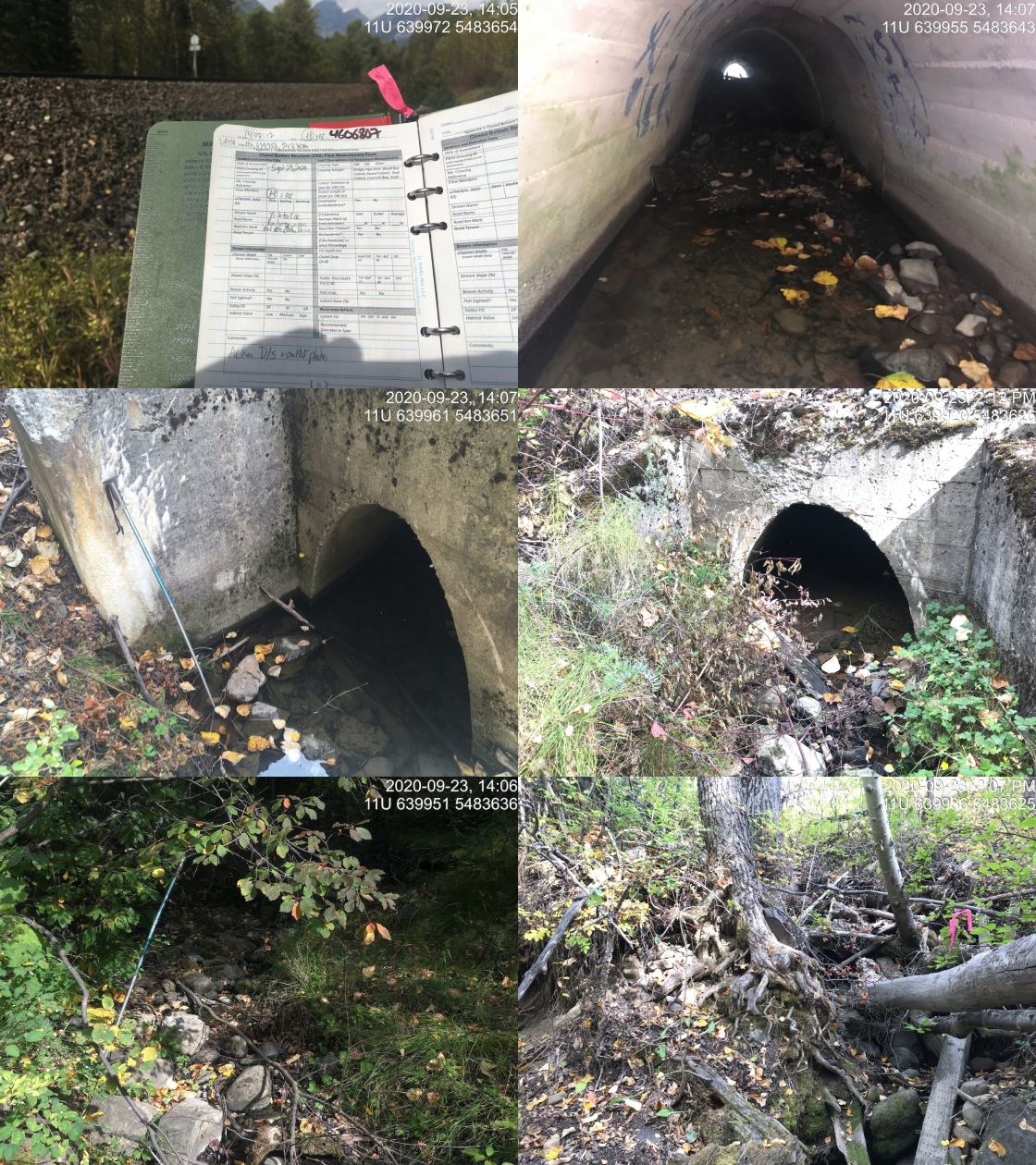
|
|||
| Comments: Concrete arch, >30% downstream of culvert for 10m likely from railway fill. Dry downstream with stagnant pools upstream. |
| Location and Stream Data |
|
Crossing Characteristics | – |
|---|---|---|---|
| Date | 2020-09-16 | Crossing Sub Type | Round Culvert |
| PSCIS ID | 197524 | Diameter (m) | 0.4 |
| External ID | 4606835 | Length (m) | 10 |
| Crew | AI, KP | Embedded | No |
| UTM Zone | 11 | Depth Embedded (m) | – |
| Easting | 644829 | Resemble Channel | No |
| Northing | 5559116 | Backwatered | No |
| Stream | Tributary to Elk River | Percent Backwatered | – |
| Road | Spur | Fill Depth (m) | 1 |
| Road Tenure | Canfor R08370 | Outlet Drop (m) | 0.3 |
| Channel Width (m) | 1 | Outlet Pool Depth (m) | 0 |
| Stream Slope (%) | 3 | Inlet Drop | No |
| Beaver Activity | No | Slope (%) | 2.5 |
| Habitat Value | Low | Valley Fill | Deep Fill |
Photos: External ID 4606835. From top left clockwise: Road/Site Card, Barrel, Outlet, Downstream, Upstream, Inlet.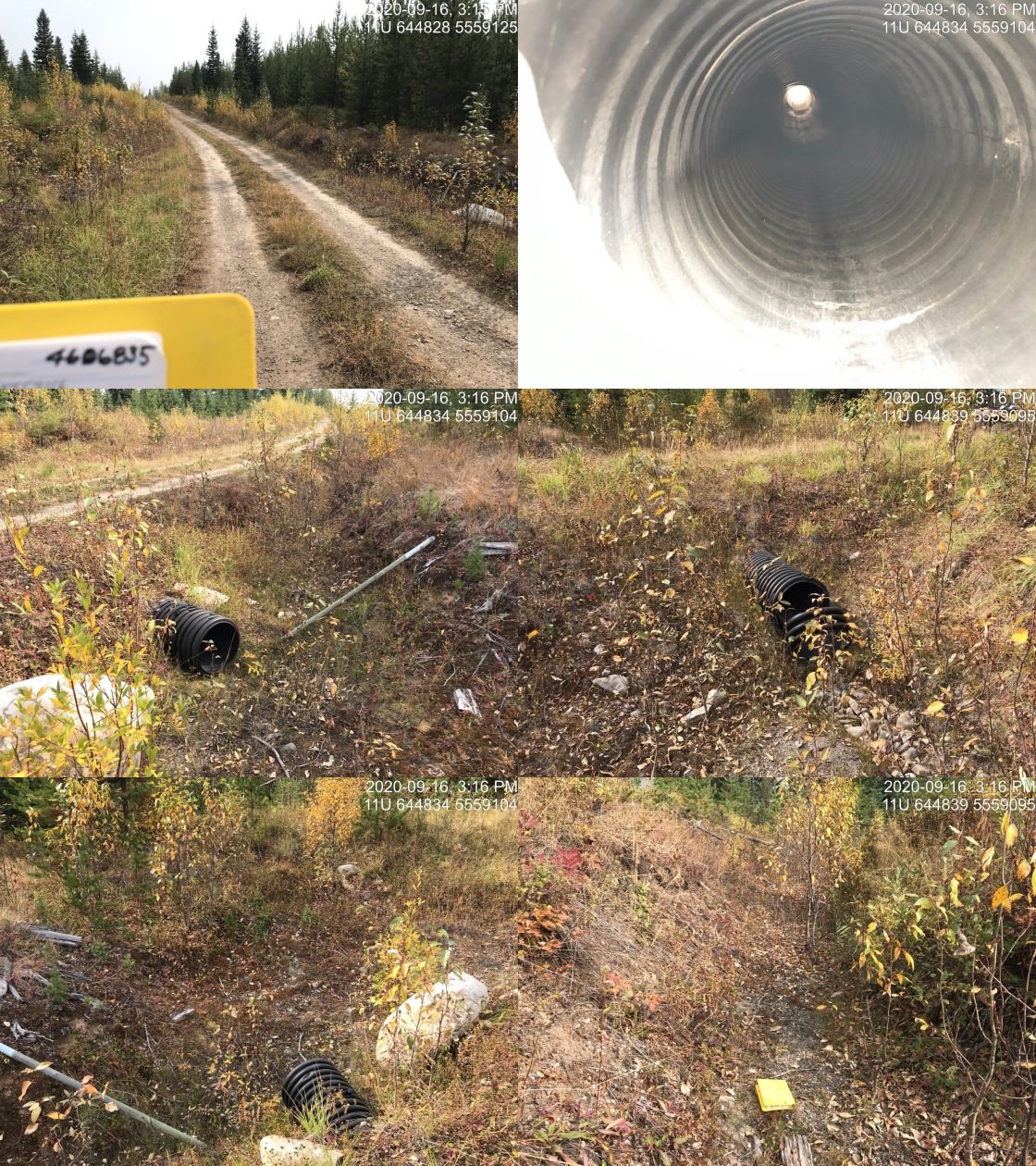
|
|||
| Comments: Road is deactivated downstream so no crossings below (4607172, 4606929). Dry vegetated channel. Not likely fish bearing at this location. |
| Location and Stream Data |
|
Crossing Characteristics | – |
|---|---|---|---|
| Date | 2020-09-18 | Crossing Sub Type | Bridge |
| PSCIS ID | 197540 | Diameter (m) | 4 |
| External ID | 4607023 | Length (m) | 18 |
| Crew | AI, KP | Embedded | – |
| UTM Zone | 11 | Depth Embedded (m) | – |
| Easting | 648041 | Resemble Channel | – |
| Northing | 5499983 | Backwatered | – |
| Stream | McCool Creek | Percent Backwatered | – |
| Road | – | Fill Depth (m) | – |
| Road Tenure | Canfor R08477 | Outlet Drop (m) | – |
| Channel Width (m) | – | Outlet Pool Depth (m) | – |
| Stream Slope (%) | – | Inlet Drop | – |
| Beaver Activity | No | Slope (%) | – |
| Habitat Value | – | Valley Fill | – |
Photos: External ID 4607023. From top left clockwise: Road/Site Card, Barrel, Outlet, Downstream, Upstream, Inlet.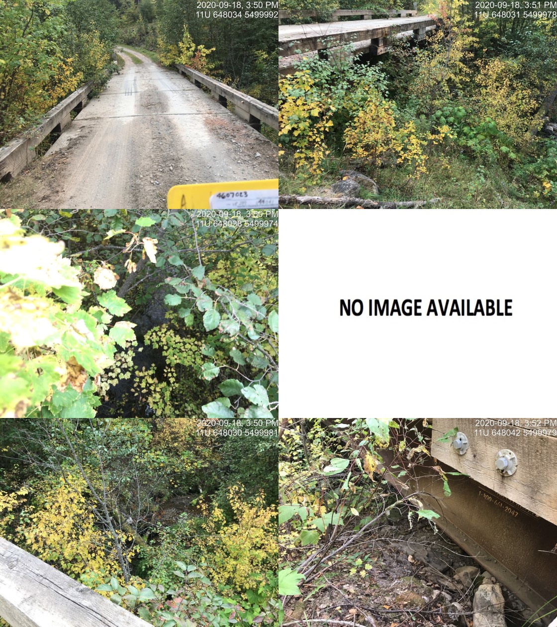
|
|||
| Comments: Bridge. |
| Location and Stream Data |
|
Crossing Characteristics | – |
|---|---|---|---|
| Date | 2020-09-18 | Crossing Sub Type | Bridge |
| PSCIS ID | 197539 | Diameter (m) | 4 |
| External ID | 2020091801 | Length (m) | 18 |
| Crew | AI, KP | Embedded | – |
| UTM Zone | 11 | Depth Embedded (m) | – |
| Easting | 648381 | Resemble Channel | – |
| Northing | 5499536 | Backwatered | – |
| Stream | McCool Creek | Percent Backwatered | – |
| Road | Hadner FSR | Fill Depth (m) | – |
| Road Tenure | FLNR 6946 | Outlet Drop (m) | – |
| Channel Width (m) | – | Outlet Pool Depth (m) | – |
| Stream Slope (%) | – | Inlet Drop | – |
| Beaver Activity | No | Slope (%) | – |
| Habitat Value | – | Valley Fill | – |
Photos: External ID 2020091801. From top left clockwise: Road/Site Card, Barrel, Outlet, Downstream, Upstream, Inlet.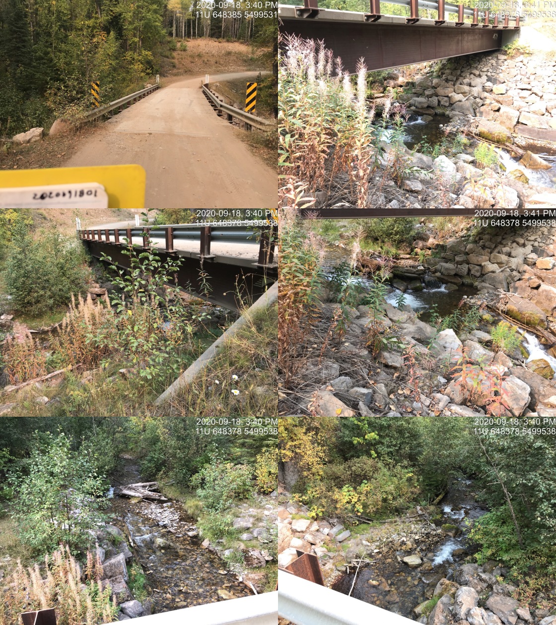
|
|||
| Comments: Bridge. |
| Location and Stream Data |
|
Crossing Characteristics | – |
|---|---|---|---|
| Date | 2020-09-22 | Crossing Sub Type | Bridge |
| PSCIS ID | 197543 | Diameter (m) | 1.2 |
| External ID | 2020092201 | Length (m) | 12 |
| Crew | AI, KP | Embedded | – |
| UTM Zone | 11 | Depth Embedded (m) | – |
| Easting | 634969 | Resemble Channel | – |
| Northing | 5484828 | Backwatered | – |
| Stream | Tributary to Lizard Creek | Percent Backwatered | – |
| Road | Lazy Lizard Lower | Fill Depth (m) | – |
| Road Tenure | Unknown | Outlet Drop (m) | – |
| Channel Width (m) | – | Outlet Pool Depth (m) | – |
| Stream Slope (%) | – | Inlet Drop | – |
| Beaver Activity | No | Slope (%) | – |
| Habitat Value | – | Valley Fill | – |
Photos: External ID 2020092201. From top left clockwise: Road/Site Card, Barrel, Outlet, Downstream, Upstream, Inlet.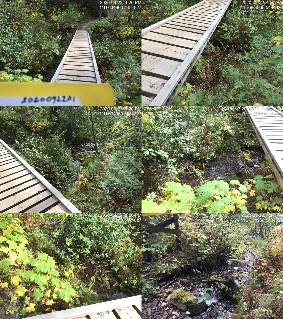
|
|||
| Comments: Bike trail. |
| Location and Stream Data |
|
Crossing Characteristics | – |
|---|---|---|---|
| Date | 2020-09-23 | Crossing Sub Type | Bridge |
| PSCIS ID | 197544 | Diameter (m) | 1.2 |
| External ID | 2020092301 | Length (m) | 8 |
| Crew | AI, KP | Embedded | – |
| UTM Zone | 11 | Depth Embedded (m) | – |
| Easting | 636474 | Resemble Channel | – |
| Northing | 5483873 | Backwatered | – |
| Stream | Tributary to Lizard Creek | Percent Backwatered | – |
| Road | Trail | Fill Depth (m) | – |
| Road Tenure | Unknown | Outlet Drop (m) | – |
| Channel Width (m) | – | Outlet Pool Depth (m) | – |
| Stream Slope (%) | – | Inlet Drop | – |
| Beaver Activity | No | Slope (%) | – |
| Habitat Value | – | Valley Fill | – |
Photos: External ID 2020092301. From top left clockwise: Road/Site Card, Barrel, Outlet, Downstream, Upstream, Inlet.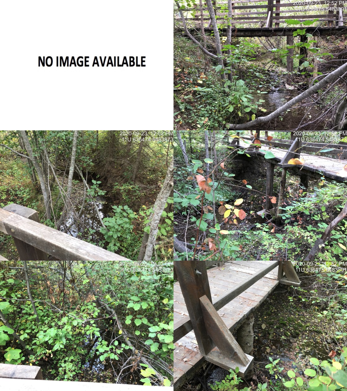
|
|||
| Comments: Trail. Stream has been diverted to beside the road. |
| Location and Stream Data |
|
Crossing Characteristics | – |
|---|---|---|---|
| Date | 2020-09-23 | Crossing Sub Type | Round Culvert |
| PSCIS ID | 197549 | Diameter (m) | 0.6 |
| External ID | 2020092302 | Length (m) | 14 |
| Crew | AI, KP | Embedded | Yes |
| UTM Zone | 11 | Depth Embedded (m) | 0.03 |
| Easting | 640218 | Resemble Channel | Yes |
| Northing | 5481065 | Backwatered | No |
| Stream | Tributary to Elk River | Percent Backwatered | – |
| Road | Hill Road | Fill Depth (m) | 1.2 |
| Road Tenure | Unknown | Outlet Drop (m) | 0 |
| Channel Width (m) | 1.5 | Outlet Pool Depth (m) | 0 |
| Stream Slope (%) | 0 | Inlet Drop | No |
| Beaver Activity | No | Slope (%) | 0.5 |
| Habitat Value | Low | Valley Fill | Deep Fill |
Photos: External ID 2020092302. From top left clockwise: Road/Site Card, Barrel, Outlet, Downstream, Upstream, Inlet.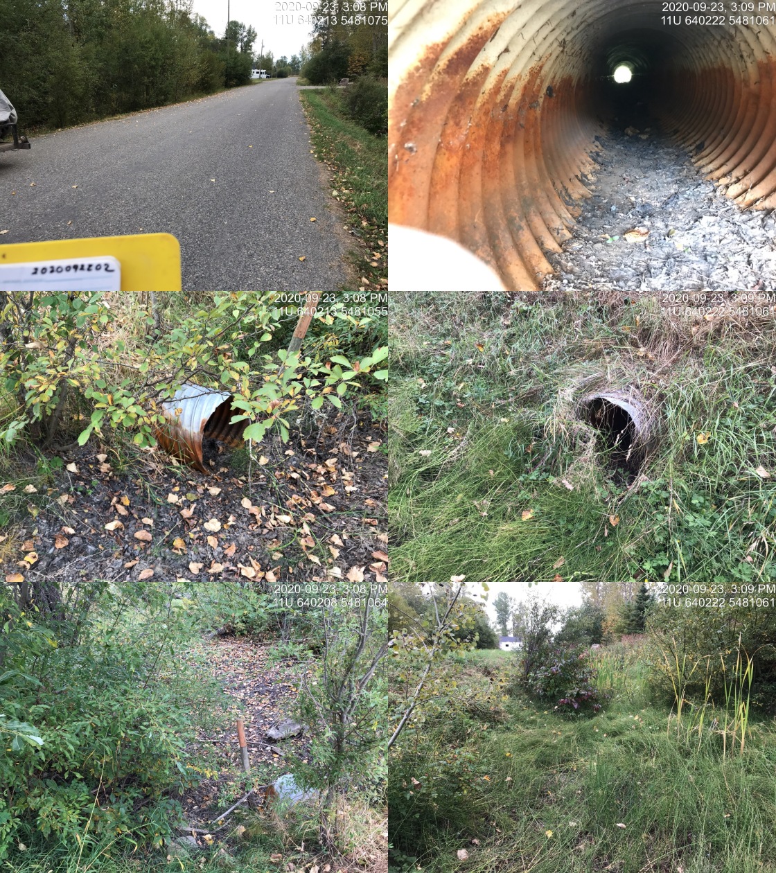
|
|||
| Comments: Dry vegetated channel. Not likely fish habitat. |
| Location and Stream Data |
|
Crossing Characteristics | – |
|---|---|---|---|
| Date | 2020-09-23 | Crossing Sub Type | Round Culvert |
| PSCIS ID | 197550 | Diameter (m) | 0.6 |
| External ID | 2020092303 | Length (m) | 15 |
| Crew | AI, KP | Embedded | No |
| UTM Zone | 11 | Depth Embedded (m) | – |
| Easting | 640227 | Resemble Channel | No |
| Northing | 5481028 | Backwatered | No |
| Stream | Tributary to Elk River | Percent Backwatered | – |
| Road | Driveway | Fill Depth (m) | 1 |
| Road Tenure | Unknown | Outlet Drop (m) | 0 |
| Channel Width (m) | 1.5 | Outlet Pool Depth (m) | 0 |
| Stream Slope (%) | 2 | Inlet Drop | No |
| Beaver Activity | No | Slope (%) | 0.5 |
| Habitat Value | Low | Valley Fill | Deep Fill |
Photos: External ID 2020092303. From top left clockwise: Road/Site Card, Barrel, Outlet, Downstream, Upstream, Inlet.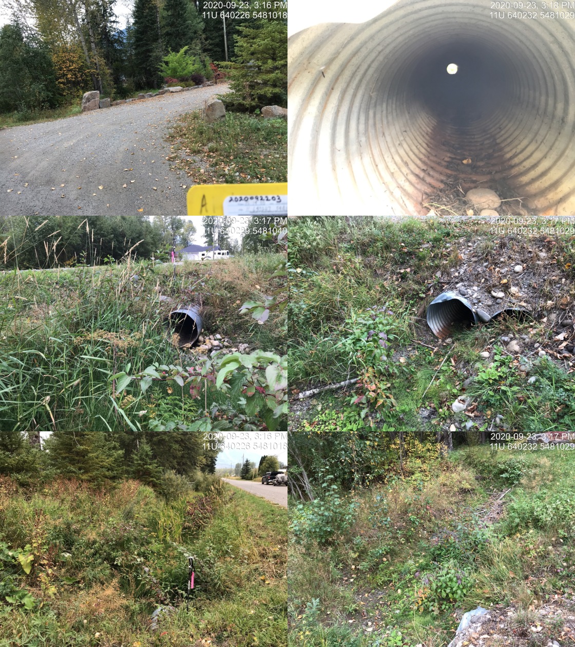
|
|||
| Comments: Dry, mostly vegetated channel. Not likely fish habitat. Two pipes, one buried by fill. Inlet elevated resulting in small are of wetland vegetation upstream. |
| Location and Stream Data |
|
Crossing Characteristics | – |
|---|---|---|---|
| Date | 2020-09-23 | Crossing Sub Type | Bridge |
| PSCIS ID | 197566 | Diameter (m) | 1.2 |
| External ID | 2020092310 | Length (m) | 14 |
| Crew | KP, AI | Embedded | – |
| UTM Zone | 11 | Depth Embedded (m) | – |
| Easting | 636029 | Resemble Channel | – |
| Northing | 5484419 | Backwatered | – |
| Stream | Tributary to Lizard Creek | Percent Backwatered | – |
| Road | Lazy Lizard Lower | Fill Depth (m) | – |
| Road Tenure | Unknown | Outlet Drop (m) | – |
| Channel Width (m) | – | Outlet Pool Depth (m) | – |
| Stream Slope (%) | – | Inlet Drop | – |
| Beaver Activity | No | Slope (%) | – |
| Habitat Value | – | Valley Fill | – |
Photos: External ID 2020092310. From top left clockwise: Road/Site Card, Barrel, Outlet, Downstream, Upstream, Inlet.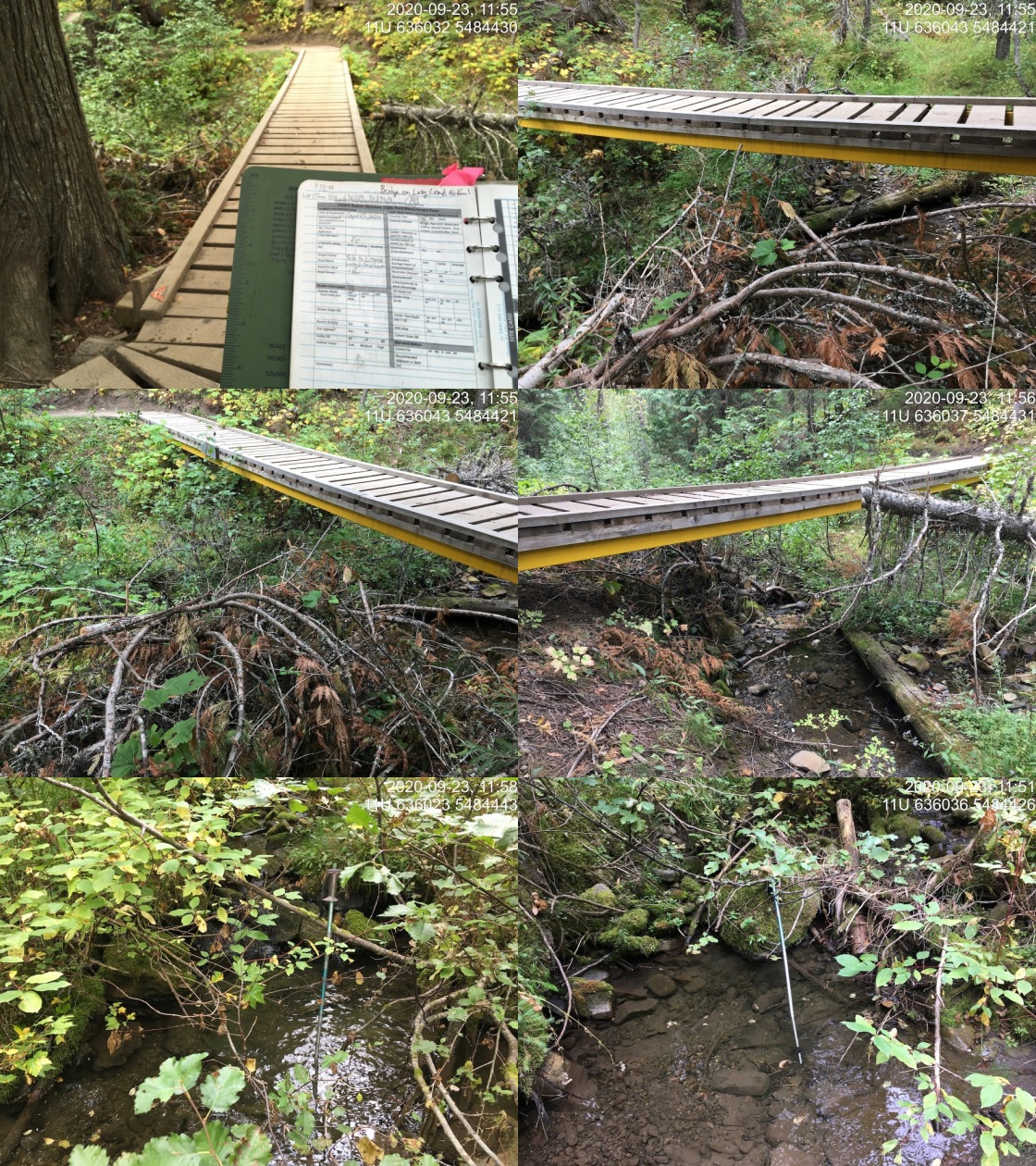
|
|||
| Comments: Nice wooden pedestrian/bike bridge for recreational use. |
| Location and Stream Data |
|
Crossing Characteristics | – |
|---|---|---|---|
| Date | 2020-10-14 | Crossing Sub Type | Bridge |
| PSCIS ID | – | Diameter (m) | 3 |
| External ID | 2020101410 | Length (m) | 7 |
| Crew | MF, AI | Embedded | – |
| UTM Zone | 11 | Depth Embedded (m) | – |
| Easting | 643131 | Resemble Channel | – |
| Northing | 5492766 | Backwatered | – |
| Stream | Tributary to Hartley Creek | Percent Backwatered | – |
| Road | Hartley Lake Rd | Fill Depth (m) | – |
| Road Tenure | – | Outlet Drop (m) | – |
| Channel Width (m) | – | Outlet Pool Depth (m) | – |
| Stream Slope (%) | – | Inlet Drop | – |
| Beaver Activity | No | Slope (%) | – |
| Habitat Value | – | Valley Fill | – |
Photos: External ID 2020101410. From top left clockwise: Road/Site Card, Barrel, Outlet, Downstream, Upstream, Inlet.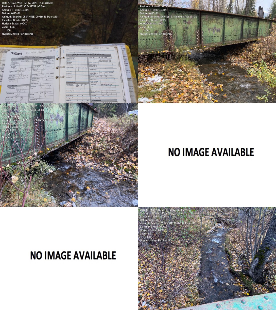
|
|||
| Comments: Old train bridge unmodelled. Private land access point. |
| Location and Stream Data |
|
Crossing Characteristics | – |
|---|---|---|---|
| Date | 2020-10-16 | Crossing Sub Type | Bridge |
| PSCIS ID | – | Diameter (m) | 8 |
| External ID | 2020101610 | Length (m) | 3 |
| Crew | AI, MF | Embedded | – |
| UTM Zone | 11 | Depth Embedded (m) | – |
| Easting | 638067 | Resemble Channel | – |
| Northing | 5483493 | Backwatered | – |
| Stream | Stove Creek | Percent Backwatered | – |
| Road | Trail | Fill Depth (m) | – |
| Road Tenure | – | Outlet Drop (m) | – |
| Channel Width (m) | – | Outlet Pool Depth (m) | – |
| Stream Slope (%) | – | Inlet Drop | – |
| Beaver Activity | No | Slope (%) | – |
| Habitat Value | – | Valley Fill | – |
Photos: External ID 2020101610. From top left clockwise: Road/Site Card, Barrel, Outlet, Downstream, Upstream, Inlet.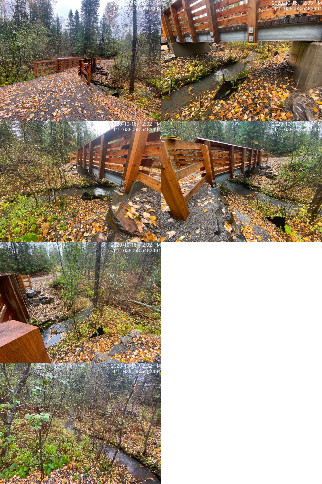
|
|||
| Comments: New bridge |
| Location and Stream Data |
|
Crossing Characteristics | – |
|---|---|---|---|
| Date | 2020-10-16 | Crossing Sub Type | Bridge |
| PSCIS ID | – | Diameter (m) | 12 |
| External ID | 2020101611 | Length (m) | 2 |
| Crew | AI, MF | Embedded | – |
| UTM Zone | 11 | Depth Embedded (m) | – |
| Easting | 637994 | Resemble Channel | – |
| Northing | 5483701 | Backwatered | – |
| Stream | Stove Creek | Percent Backwatered | – |
| Road | Trail | Fill Depth (m) | – |
| Road Tenure | – | Outlet Drop (m) | – |
| Channel Width (m) | – | Outlet Pool Depth (m) | – |
| Stream Slope (%) | – | Inlet Drop | – |
| Beaver Activity | No | Slope (%) | – |
| Habitat Value | – | Valley Fill | – |
Photos: External ID 2020101611. From top left clockwise: Road/Site Card, Barrel, Outlet, Downstream, Upstream, Inlet.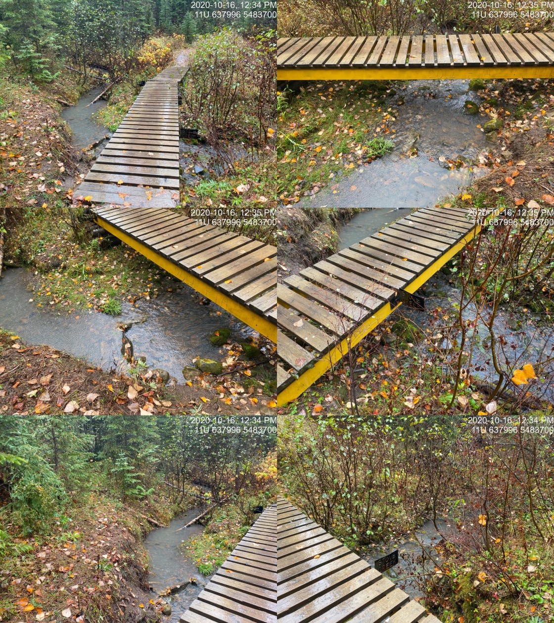
|
|||
| Comments: Bridge. Fry observed throughout stream. |