Appendix - 197555 - Tributary to Elk River
Site Location
Crossing 197555 is located on a tributary to Elk River, approximately 900m upstream from the confluence with the Elk River. The crossing is located on the Elk River FSR approximately 10km north of Elkford, BC. The Elk River FSR is a gravel forest tenure road (forest file id 0103) with active log hauling at the time of the survey.
Background
At the crossing location, the stream is 4th order with a watershed area upstream of the road of approximately 17km2. The elevation of the watershed ranges from a maximum of 2900 to 1400m at the culvert. Upstream of the crossing, there are no anthropogenic barriers on the mainstem. Although there are two modelled crossings on small tributaries that enter the stream approximately 1.5km upstream of the road, machinery operators encountered onsite indicated that they had been removed during road deactivation. No fisheries information was available for the stream (MoE 2020d) however westslope cutthroat trout, bull trout, mountain whitefish, brook trout, longnose sucker and longnose dace (among other species) have been recorded downstream in the Elk River (MoE 2020b).
PSCIS stream crossing 197555 was ranked as a high priority for follow up with habitat confirmation due to the large amount of habitat modelled upstream of the crossing. The habitat confirmation was completed on September 16, 2020. A map of the watershed including areas surveyed is provided in Attachment 1 – Map 082J.103.
Stream Characteristics at Crossing
At the time of the survey, the un-embedded and non-backwatered 1.5m diameter crossing was considered a barrier to upstream fish passage with a pipe length of 49m, a culvert slope of 3.5%, a stream width ratio of 2.3 and an outlet drop of 1.48m (Table 5.34). Water temperature was 6\(^\circ\)C, pH was 7.2 and conductivity was 378uS/cm.
Stream Characteristics Downstream
The stream was surveyed downstream from the culvert for 700m. Overall, total cover amount was rated as moderate with deep pools dominant. Cover was also present as small woody debris, large woody debris, boulders, and overhanging vegetation (Table 5.35, Figure 5.40). The average channel width was 4.4m, the average wetted width was 3.1m and the average gradient was 3.6%. The dominant substrate was cobbles with gravels subdominant . There were frequent pools formed by small and large woody debris ranging from 0.3 - 0.75m in depth (average residual depth = 0.4m). Frequent pockets of gravels suitably sized for resident and fluvial salmonid spawning were also present. Habitat value was rated as high with good potential for fry/juvenile salmonid rearing.
Stream Characteristics Upstream
The stream was surveyed upstream from the culvert for 675m. Overall, total cover amount was rated as abundant with boulders as the dominant type. Cover was also present as small woody debris, large woody debris, undercut banks, deep pools, and overhanging vegetation (Table 5.35, Figure 5.41). The average channel width was 5.9m, the average wetted width was 3.8m and the average gradient was 5.9%. The dominant substrate was cobbles with boulders subdominant. The stream had good flows, pools to 0.6m deep (average residual depth = 0.4m) were present and pockets of gravel suitable for spawning were observed throughout. Infrequent large woody debris jams to 0.5m high were also noted. Habitat value was rated as high for fry and juvenile westslope cutthrout trout and bull trout rearing.
Fish Sampling
To assess potential impacts of the culvert on fish communities in the stream, electrofishing was conducted upstream and downstream of the crossing. One 150m site was sampled upstream and one 315m site was sampled downstream. One bull trout was captured downstream and no fish were captured upstream (Figure 5.42). Raw results are included in digital format as Attachment 2 and summarized in Table 5.36.
Structure Remediation and Cost Estimate
Structure replacement with an open bottomed culvert is recommended to provide access to the habitat located upstream of PSCIS crossing 197555. Due to the large amount of fill on the road (8m) the size of a replacement bridge was estimated at 25m. The cost for work is estimated at $312,000 for a cost benefit of 19.2linear m/$1000 and 113.5m2/$1000.
Conclusion
There is an estimated 6km of mainstem habitat upstream of crossing 197555 with habitat in the areas surveyed rated as high value for fry and juvenile salmonid rearing. However, fish sampling results indicate that westslope cutthrout trout are not currently utilizing the stream and densities of bull trout are very low. This could be the result of the cold water conditions due to the positioning of the watershed at high elevation in the generally cold Rocky Mountain setting. Elk River FSR is a forest tenure liscensee road of the Ministry of Forests, Lands, Natural Resource Operations & Rural Development. The crossing was ranked as a moderate priority for proceeding to design for replacement with an open bottomed structure.
| Location and Stream Data |
|
Crossing Characteristics | – |
|---|---|---|---|
| Date | 2020-09-16 | Crossing Sub Type | Round Culvert |
| PSCIS ID | 197555 | Diameter (m) | 1.5 |
| External ID | – | Length (m) | 49 |
| Crew | KP, AI | Embedded | No |
| UTM Zone | 11 | Depth Embedded (m) | – |
| Easting | 646735 | Resemble Channel | No |
| Northing | 5554534 | Backwatered | No |
| Stream | Tributary to Elk River | Percent Backwatered | – |
| Road | Elk River FSR | Fill Depth (m) | 8 |
| Road Tenure | FLNR 0103 | Outlet Drop (m) | 1.48 |
| Channel Width (m) | 3.5 | Outlet Pool Depth (m) | 1.3 |
| Stream Slope (%) | 1.5 | Inlet Drop | Yes |
| Beaver Activity | No | Slope (%) | 3.5 |
| Habitat Value | High | Valley Fill | Deep Fill |
Photos: From top left clockwise: Road/Site Card, Barrel, Outlet, Downstream, Upstream, Inlet.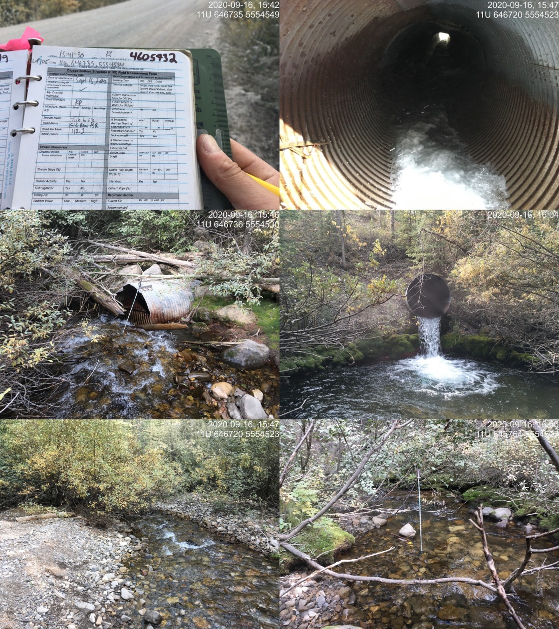
|
| Location | Length Surveyed (m) | Channel Width (m) | Wetted Width (m) | Pool Depth (m) | Gradient (%) | Total Cover | Habitat Value |
|---|---|---|---|---|---|---|---|
| Upstream | 675 | 5.9 | 3.8 | 0.4 | 5.9 | abundant | high |
| Downstream | 700 | 4.4 | 3.1 | 0.4 | 3.6 | moderate | high |
| Site | Location | Width (m) | Length (m) | Area (m2) | Effort (s) | Effort (s/m2) |
|---|---|---|---|---|---|---|
| 4 | Downstream | 3.1 | 315 | 976 | 550 | 0.6 |
| 3 | Upstream | 3.8 | 150 | 570 | 177 | 0.3 |
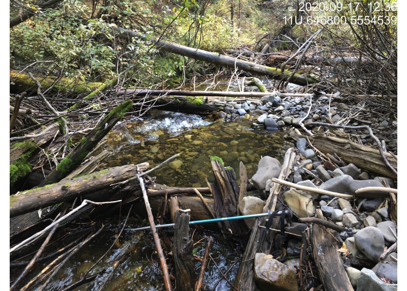
Figure 5.40: Typical habitat downstream of PSCIS crossing 197555.
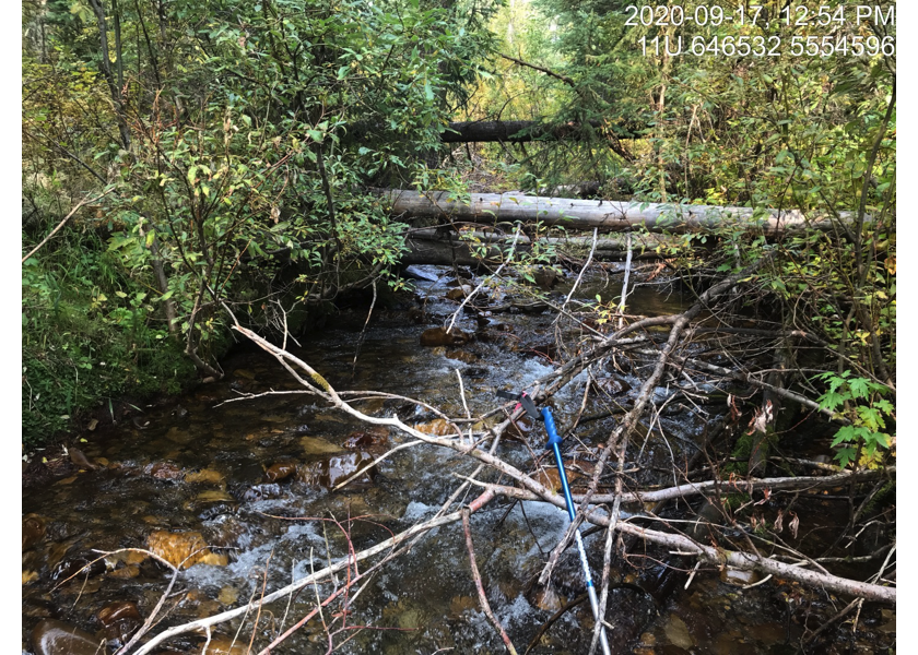
Figure 5.41: Typical habitat upstream of PSCIS crossing 197555.
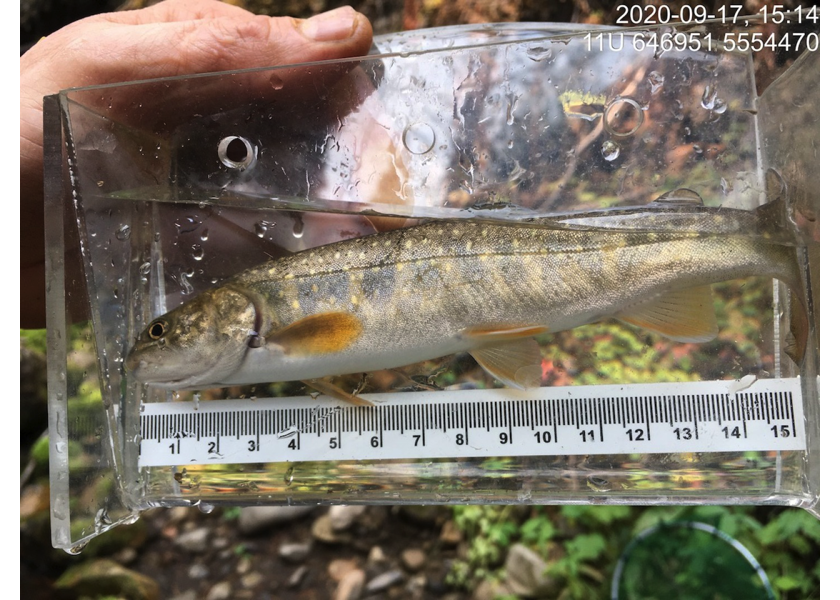
Figure 5.42: Bull trout captured downstream of PSCIS crossing 197555.