4 Results and Discussion
Field assessments were conducted between September 16 2020 and October 17 2020 by Allan Irvine, R.P.Bio, Mark Fjeld, BiT, Kyle Prince, P,Biol, and Chad Hughes, Ecologist. Mapping was completed by Hillcrest Geographics with a geopackage of project specific layers available here. Results of Planning, Phase 1 and Phase 2 assessments are summarized in Figure 4.1 with additional details provided in sections below.
Figure 4.1: Map of fish passage and habitat confirmation results
4.1 Planning
Review of the PSCIS database indicated that prior to 2020, 480 assessments for fish passage (Phase 1) and 11 habitat confirmations (Phase 2) had been conducted at crossing structures within the Upper Elk River. Within the Flathead River watershed, 126 fish passage assessments and 3 habitat confirmations had been conducted.
Following review of background literature, fisheries information, PSCIS and bcfishpass outputs, 241 modelled and PSCIS crossings were reviewed to select sites for follow up with Phase 1 and 2 assessments. In total, 160 crossings were reviewed in the Upper Elk River watershed and 81 crossings were reviewed in the Flathead River watershed. Not including sites surveyed in the field in 2020, 17 crossings ranked as high priority for future follow up with Phase 1 and/or Phase 2 assessments, 39 crossings ranked as moderate priorities, 90 crossings ranked as low priorities and 23 crossings ranked as “no fix”. Results are presented in Figure 4.1 and included as a zipped Google Earth kml file (Attachment 1).
4.2 Phase 1
During 2020 field surveys, a total of 72 Phase 1 assessments were conducted with 17 crossings considered “passable”, 8 crossings considered “potential” barriers and 43 crossings considered “barriers” according to threshold values based on culvert embedment, outlet drop, slope, diameter (relative to channel size) and length (MoE 2011). Site maps are presented in Attachment 2 with a summary of crossings assessed, a cost benefit analysis and priority ranking for follow up for Phase 1 sites presented in Table 4.1. Detailed data with photos are presented in Appendix - Phase 1 Fish Passage Assessment Data and Photos.
Barrier passability criteria used in this project follows MoE (2011), and reflects an estimation for the passage of a juvenile salmon or small resident rainbow trout (Clarkin et al. 2005 ; Bell 1991; Thompson 2013). As noted in Bourne et al. (2011), with a detailed review of different criteria in Kemp and O’Hanley (2010), passability of barriers can be quantified in many different ways. Fish physiology (i.e. species, length, swim speeds) as well as the temporal variation of physical characteristics (ex. due to flow volumes/velocities a particular culvert is passable 50% of the time to fish with a defined physiological capacity) make defining passability difficult with important implications for watershed connectivity modelling (Bourne et al. 2011; Shaw et al. 2016; Mahlum et al. 2014; Kemp and O’Hanley 2010).
| ID | Stream | Road | Habitat Value (priority) | Result (Score) | Stream Width (m) | Fix | Cost Est ( $K) | Habitat Upstream (km) | Cost Benefit (m / $K) | Cost Benefit (m2 / $K) |
|---|---|---|---|---|---|---|---|---|---|---|
| 197520 | Tributary to Elk River | Elk River FSR | Medium (low) | Barrier (26) | 2.5 | OBS | 125 | 2.49 | 19.9 | 49.8 |
| 197521 | Tributary to Elk River | Elk River FSR | Medium (low) | Barrier (21) | 2 | OBS | 125 | 3.86 | 30.9 | 61.8 |
| 197522 | Tributary to Elk River | Elk River FSR | Low (low) | Barrier (34) | 1 | SS-CBS | – | – | – | – |
| 197523 | Tributary to Lowe Creek | Elk River FSR | Low (low) | Potential (16) | 1.1 | SS-CBS | 25 | 1.43 | 57.2 | 62.9 |
| 197524 | Tributary to Elk River | Spur | Low (low) | Barrier (31) | 1 | SS-CBS | 25 | 1.77 | 70.8 | 70.8 |
| 197525 | Tributary to Elk River | Spur | Low (low) | Barrier (21) | 1 | RM | – | 1.8 | – | – |
| 197526 | Tributary to Elk River | Elk River FSR | Low (low) | Barrier (31) | 3.1 | OBS | 125 | 6.6 | 52.8 | 163.7 |
| 197527 | Crossing Creek | Elk River FSR | Low (low) | Barrier (26) | 2.5 | OBS | 125 | 12.34 | 98.7 | 246.8 |
| 197528 | Tributary to Whiting Creek | Lower Elk Valley Rd | Low (low) | Potential (15) | 0.5 | SS-CBS | 1000 | 2.32 | 2.3 | 1.2 |
| 197529 | Littlemoor Creek | Lower Elk Valley Rd | Low (low) | Barrier (34) | 1 | SS-CBS | 1000 | 4.95 | 5 | 5 |
| 197530 | Dalzell Creek | Airport Road | – | Passable (14) | 5 | – | – | 2.51 | – | – |
| 197531 | Dalzell Creek | Driveway | Medium (low) | Potential (16) | 2.5 | OBS | 5000 | 2.03 | 0.4 | 1 |
| 197532 | Dalzell Creek | Driveway | Medium (low) | Potential (16) | 1.2 | SS-CBS | 1000 | 1.76 | 1.8 | 2.1 |
| 197533 | Brule Creek | Busato Road | High (high) | Barrier (39) | 7.1 | OBS | 710 | 36.95 | 52 | 369.5 |
| 197534 | Weigart Creek | Highway 43 | High (high) | Barrier (34) | 4.3 | OBS | 5000 | 20.38 | 4.1 | 17.5 |
| 197535 | Brule Creek | Private | – | Unknown (0) | – | – | – | 36.06 | – | – |
| 197536 | Brule Creek | Spur | – | Unknown (0) | – | – | – | 34.66 | – | – |
| 197537 | North Littlemoor Creek | Highway 43 | Medium (mod) | Barrier (42) | 1.6 | SS-CBS | 1000 | 3.77 | 3.8 | 6 |
| 197538 | Littlemoor Creek | Highway 43 | Medium (mod) | Barrier (42) | 1.2 | SS-CBS | 1000 | 4.37 | 4.4 | 5.2 |
| 197539 | McCool Creek | Hadner FSR | – | Passable (3) | – | – | – | 12.04 | – | – |
| 197540 | McCool Creek | – | – | Passable (3) | – | – | – | 3.41 | – | – |
| 197541 | Tributary to Elk River | Hadner FSR | Medium (low) | Barrier (36) | 2.9 | OBS | 162 | 0 | 0 | 0 |
| 197542 | Hartley Creek | Dicken Road | High (high) | Barrier (34) | 3.5 | OBS | 1000 | 13.07 | 13.1 | 45.7 |
| 197543 | Tributary to Lizard Creek | Lazy Lizard Lower | – | Passable (0) | – | – | – | – | – | – |
| 197544 | Tributary to Lizard Creek | Trail | – | Passable (0) | – | – | – | – | – | – |
| 197545 | Tributary to Elk River | Mt Mclean Road | – | Passable (14) | 2.7 | – | – | 0.86 | – | – |
| 197546 | Tributary to Elk River | McGiverin Road | Low (low) | Barrier (21) | 0.5 | SS-CBS | 100 | 0.5 | 5 | 2.5 |
| 197547 | Tributary to Elk River | Railway | – | Passable (10) | 0.5 | – | – | 0.54 | – | – |
| 197548 | Tributary to Elk River | Robinson Road | – | Passable (11) | 1.2 | – | – | 0.98 | – | – |
| 197549 | Tributary to Elk River | Hill Road | – | Passable (11) | 1.5 | – | – | – | – | – |
| 197550 | Tributary to Elk River | Driveway | Low (low) | Potential (19) | 1.5 | SS-CBS | – | – | – | – |
| 197551 | Tributary to Elk River | Elk River FSR | – | Passable (0) | – | – | – | 1.09 | – | – |
| 197552 | Tributary to Elk River | Elk River FSR | Low (low) | Barrier (21) | 2.3 | OBS | 125 | 1.33 | 10.6 | 24.5 |
| 197553 | Lowe Creek | Elk River FSR | High (mod) | Potential (19) | 2.5 | OBS | 125 | 6.45 | 51.6 | 129 |
| 197554 | Tributary to Elk River | Elk River FSR | Medium (low) | Potential (16) | 1 | SS-CBS | 25 | 1.5 | 60 | 60 |
| 197555 | Tributary to Elk River | Elk River FSR | High (high) | Barrier (42) | 3.5 | OBS | 312 | 5.99 | 19.2 | 67.2 |
| 197556 | Tributary to Elk River | Lower Elk Valley Rd | Low (low) | Potential (18) | 0 | SS-CBS | 1000 | 1.13 | 1.1 | 0 |
| 197557 | North Littlemoor Creek | Lower Elk Valley Rd | Low (low) | Barrier (29) | 1.5 | SS-CBS | 1000 | 4.6 | 4.6 | 6.9 |
| 197558 | Dalzell Creek | Lower Elk Valley Rd | Medium (low) | Barrier (24) | 3.8 | OBS | 5000 | 2.23 | 0.4 | 1.7 |
| 197559 | Brule Creek | Highway 43 | Medium (high) | Barrier (22) | 6.1 | OBS | 6100 | 36.82 | 6 | 36.8 |
| 197560 | Tributary to Elk River | Line Creek Mine Rd | Low (low) | Barrier (21) | 0.5 | SS-CBS | 200 | 2.49 | 12.4 | 6.2 |
| 197561 | Hollow Creek | Highway 43 | Low (low) | Barrier (39) | 1.1 | SS-CBS | 1000 | 0.25 | 0.2 | 0.3 |
| 197562 | Whiting Creek | Highway 43 | Low (low) | Barrier (23) | 0.6 | SS-CBS | 1000 | 0.96 | 1 | 0.6 |
| 197563 | Grave Creek | – | – | Unknown (0) | – | – | – | 5.84 | – | – |
| 197564 | Grave Creek | – | Low (low) | Barrier (20) | 0.1 | SS-CBS | 25 | 5.73 | 229.2 | 22.9 |
| 197565 | Tributary to Grave Creek | – | Low (low) | Barrier (26) | 1.5 | SS-CBS | 25 | 5.45 | 218 | 327 |
| 197566 | Tributary to Lizard Creek | Lazy Lizard Lower | – | Passable (0) | – | – | – | – | – | – |
| 197567 | Tributary to Elk River | Cokato Road | Low (low) | Barrier (23) | 0.65 | SS-CBS | 200 | 0.69 | 3.5 | 2.2 |
| 197568 | Tributary to Elk River | Railway | – | Passable (13) | 1.5 | – | – | 0.78 | – | – |
| 197569 | Tributary to Elk River | Cokato Road | Low (low) | Barrier (32) | 2.1 | OBS | 1000 | 1.28 | 1.3 | 2.7 |
| 197570 | Cokato Creek | Cokato Road | Low (low) | Barrier (26) | 4.5 | OBS | 1000 | 1.76 | 1.8 | 7.9 |
| 197571 | Tributary to Elk River | Cokato Road | Low (low) | Barrier (21) | 4.1 | OBS | 1000 | 1.9 | 1.9 | 7.8 |
| 197572 | Tributary to Elk River | Railway | Low (low) | Barrier (24) | 2.7 | OBS | 500 | 1.93 | 3.9 | 10.4 |
| 197573 | Tributary to Elk River | Highline Drive | Medium (mod) | Barrier (37) | 2.3 | OBS | 1900 | 0.63 | 0.3 | 0.8 |
| 197574 | Tributary to Elk River | Fernie ski hill | Low (low) | Barrier (32) | 1.4 | SS-CBS | 25 | 0.29 | 11.6 | 16.2 |
| 197575 | Tributary to Elk River | Fernie ski hill | Low (low) | Barrier (34) | 1.5 | SS-CBS | 25 | 0.29 | 11.6 | 17.4 |
| 197576 | Tributary to Elk River | Fernie ski hill | Low (low) | Barrier (39) | 1.5 | SS-CBS | 25 | 0.29 | 11.6 | 17.4 |
| 197577 | Tributary to Elk River | Fernie ski hill | Low (low) | Barrier (26) | 1.3 | SS-CBS | 25 | 0.23 | 9.2 | 12 |
| 197578 | Tributary to Elk River | Fernie Nordic Trail | Medium (mod) | Barrier (26) | 2 | OBS | 125 | 2.24 | 17.9 | 35.8 |
| 197579 | Tributary to Elk River | Highway 3 | Medium (mod) | Barrier (24) | 3.3 | OBS | 5000 | 5.27 | 1.1 | 3.5 |
| 197580 | Tributary to Elk River | Dicken Rd | Low (low) | Barrier (34) | 2.2 | OBS | 1000 | 1.38 | 1.4 | 3 |
| 197581 | Bean Creek | Dicken Rd | High (mod) | Barrier (36) | 2 | OBS | 1000 | 0.63 | 0.6 | 1.3 |
| 197582 | Hartley Creek | Highway 3 | – | Passable (6) | – | – | – | 13.46 | – | – |
| 197583 | Bean Creek | Highway 3 | Medium (mod) | Barrier (29) | 3.2 | OBS | 5000 | 3.78 | 0.8 | 2.4 |
| *4600005 | Tributary to Elk R | Hwy 3 | Low (low) | Barrier (39) | 2.7 | OBS | 5000 | 1.81 | 0.4 | 1 |
| *4603294 | Tributary to Hartley Creek | Hartley Lake Rd | Low (low) | Barrier (36) | 1.8 | SS-CBS | 25 | 1.83 | 73.2 | 131.8 |
| *4606006 | Weigert Creek | Weigert FSR | – | Unknown (0) | – | – | – | 19.17 | – | – |
| *4606515 | Tributary to Hartley Creek | Hartley Lake Rd | Low (low) | Barrier (26) | 6.7 | OBS | 168 | 1.5 | 8.9 | 59.8 |
| *4606518 | Tributary to Hartley Creek | Hartley Lake Rd | – | Passable (0) | – | – | – | – | – | – |
| *2020101410 | Tributary to Hartley Creek | Hartley Lake Rd | – | Passable (0) | – | – | – | – | – | – |
| *2020101610 | Stove Creek | Trail | – | Passable (0) | – | – | – | – | – | – |
| *2020101611 | Stove Creek | Trail | – | Passable (0) | – | – | – | – | – | – |
4.3 Phase 2
Habitat confirmation assessments were conducted at 15 sites with a total of approximately 15 km of stream assessed. Six crossings were rated as high priorities for proceeding to design for replacement, Eight crossings were rated as moderate priorities for proceeding to design for replacement, 0 crossings were rated as a low priority and 1 rated as “no fix”. Results are summarized in Figure 4.1 and Tables 4.2 - 4.5 with raw habitat and fish sampling data included in digital format as Attachment 3. Detailed information for each site assessed with Phase 2 assessments is included within site specific reports included as appendices to this document with maps included as Attachment 2.
| PSCIS ID | Stream | Road | UTM (11U) | Fish Species | Habitat Gain (km) | Habitat Value | Priority | Comments |
|---|---|---|---|---|---|---|---|---|
| 50152 | Tributary to Lizard Creek | Mt.Fernie Park Rd | 637987 5483407 | (WCT) | 2.7 | High | high | Newly installed culvert with large outlet drop. Cover as undercut banks, small woody debris, large woody debris and overhanging vegetation. Numerous fry observed throughout the area surveyed and abundant gravels suitable for salmonid spawning. Highest value habitat of 4 Lizard Creek tributary streams surveyed. |
| 50155 | Tributary to Lizard Creek | Island Lake Lodge Road | 635113 5484261 | EB, WCT | 1.8 | Medium | moderate | Frequent areas of gravels suitable for resident westslope cutthrout trout spawning and pools to 40cm deep associated with small and large woody debris. Fish sampling indicates westslope cutthrout trout fry densities lower upstream than downstream. |
| 50159 | Tributary to Lizard Creek | Island Lake Lodge Road | 633320 5484601 | – | 0.3 | Medium | moderate | Abundant gravels suitable for resident and fluvial westslope cutthrout trout spawning. Frequent pools to 40cm deep associated with woody debris. Within old growth cedar forest and not mapped in the freshwater atlas stream layer. Flows potentially diverted as part of a micro-hydro facilty for Island Lake Lodge. |
| 50181 | Tributary to Morrissey Creek | Lodgepole FSR | 648276 5468176 | WCT | 0.5 | Medium | high | Boulders, small woody debris, large woody debris, undercut banks, overhanging vegetation and gravels suitable for spawning. Electrofished upstream and downstream of the crossing with westslope cutthrout trout fry, juvenile and adult fish captured downstream and only parr captured upstream. Density of parr (fish/area) lower in the steeper habitat located upstream. |
| 50185 | Tributary to Morrisey Creek | River Rd | 645683 5469025 | EB, WCT | 4.5 | High | high | Good flows, pools to 0.6m deep and pockets of gravel suitable for salmonid spawning throughout. Infrequent large woody debris jams to 0.5m high. Electrofishing indicated generally higher densities of fry, parr and juvenile westslope cutthrout trout downstream when compared to upstream. |
| 50261 | Tributary to Michel Creek | Flathead FSR | 669027 5481115 | – | 0.0 | Low | no fix | A 4.4m high chute was located 200m downstream of crossing (UTM: 11U 668858 5481210) and is considered a permanent impassable barrier to upstream migration. |
| 62423 | Harriet Lake Creek | Grave Creek FSR | 660508 5524239 | WCT | 2.3 | Low | moderate | Crossing dry at time of survey. Incorrectly mapped as Grave Creek. Steep gradients in Harriet Lake Creek approximatlely 1km upstream. |
| 62425 | Grave Creek | Spur | 661486 5524426 | WCT | 0.2 | Medium | moderate | Deep pools, large woody debris and boulders present. Stream is Grave Creek mainstem that has redirected from historic channel. Higher value habitat in adjacent valley channel. Crossing is 170m downstream of 62426. Westslope cutthrout density study underway within watershed by Lotic Environmental Ltd. |
| 62426 | Grave Creek | Spur | 661611 5524460 | WCT | 1.8 | Medium | moderate | Deep pools, large woody debris and boulders present. Habitat quality decreases with distance upstream. Upstream tributary too steep at 250m upstream. Channel is Grave Creek mainstem that has redirected from historic channel. Located 170m usptream of 62425. |
| 62516 | Tributary to Lizard Creek | Island Lake Lodge Road | 636123 5484087 | (WCT) | 0.5 | Medium | moderate | Undercut banks throughout with small woody debris, large woody debris, deep pools, and overhanging vegetation also present. Abundant gravels suitable for resident westslope cutthrout trout spawning. Fry observed upstream and downstream. |
| 197533 | Brule Creek | Busato Rd | 651626 5528888 | RB, WCT, BT | 0.1 | High | high | Recommend exploring deactivation as a potential remediatory action. Culvert is located 125m below crossing 197559. |
| 197534 | Weigert Creek | Highway 43 | 650144 5532055 | – | 11.6 | High | high | Undercut banks, small woody debris, large woody debris, boulders, deep pools, and overhanging vegetation present. Abundant gravels present. Habitat increasingly complex upstream. Watershed is a habitat protection area with motor vehicle restrictions. Elk Valley Park recreation site is located downstream of the crossing. Water too cold to sample. Recommend fish sampling upstream and down. |
| 197542 | Hartley Creek | Dicken Road | 643534 5490723 | WCT, BT, EB | 7.2 | High | high | Frequent pools formed by small and large woody debris ranging from 0.3 - 0.7m in depth. Pockets of gravels suitable for resident and fluvial salmonids. Downstream crossing on Hwy 3 is passable but requires dredging to keep clear. Historic fish density information available on Ecocat for 3 upstream sites. |
| 197555 | Tributary to Elk River | Elk River FSR | 646735 5554534 | BT | 6.0 | High | moderate | Good flows, pools to 0.6m deep and pockets of gravel suitable for spawning. Infrequent large woody debris jams to 0.5m high. Sites electrofished upstream and downstream with one bull trout captured downstream within 315m site. |
| 197559 | Brule Creek | Highway 43 | 651516 5528829 | RB, WCT | 23.0 | Medium | moderate | Deep pools, boulders and undercut banks within wetted channel upstream. Adult westslope cutthout trout in outlet pool below hwy. Section of stream (670m) immediately upstream of Highway 43 subsurface during survey. Electrofished upstream only with no fish captured. |
| PSCIS ID | Embedded | Outlet Drop (m) | Diameter (m) | SWR | Slope (%) | Length (m) | Score | Result |
|---|---|---|---|---|---|---|---|---|
| 50152 | No | 0.90 | 0.9 | 2.9 | 1.5 | 30 | 37 | Barrier |
| 50155 | No | 0.22 | 0.9 | 2.5 | 2.6 | 11 | 26 | Barrier |
| 50159 | No | 1.60 | 0.8 | 3.1 | 8.0 | 12 | 36 | Barrier |
| 50181 | No | 0.95 | 1.2 | 2.2 | 7.0 | 30 | 42 | Barrier |
| 50185 | No | 0.00 | 2.2 | 2.0 | 3.4 | 17 | 29 | Barrier |
| 50261 | No | 1.80 | 2.7 | 1.7 | 12.0 | 19 | 39 | Barrier |
| 62423 | No | 0.18 | 0.9 | 1.6 | 0.5 | 12 | 21 | Barrier |
| 62425 | No | 0.47 | 1.2 | 3.1 | 7.5 | 12 | 36 | Barrier |
| 62426 | No | 0.25 | 1.2 | 2.9 | 5.0 | 12 | 31 | Barrier |
| 62516 | No | 0.49 | 1.2 | 2.1 | 5.0 | 11 | 36 | Barrier |
| 197533 | No | 0.70 | 3.3 | 2.2 | 4.0 | 20 | 39 | Barrier |
| 197534 | No | 0.15 | 3.2 | 1.3 | 3.4 | 18 | 34 | Barrier |
| 197542 | No | 0.40 | 2.6 | 1.3 | 2.0 | 20 | 34 | Barrier |
| 197555 | No | 1.48 | 1.5 | 2.3 | 3.5 | 49 | 42 | Barrier |
| 197559 | Yes | 0.00 | 2.5 | 2.4 | 2.5 | 35 | 22 | Barrier |
| PSCIS ID | Stream | Road | Result | Habitat value | Stream Width (m) | Fix | Cost Est (in $K) | Habitat Upstream (m) | Cost Benefit (m / $K) | Cost Benefit (m2 / $K) |
|---|---|---|---|---|---|---|---|---|---|---|
| 50152 | Tributary to Lizard Creek | Mt.Fernie Park Rd | Barrier | High | 2.6 | OBS | 438 | 2700 | 6.2 | 16 |
| 50155 | Tributary to Lizard Creek | Island Lake Lodge Road | Barrier | Medium | 2.2 | OBS | 125 | 1800 | 14.4 | 31.7 |
| 50159 | Tributary to Lizard Creek | Island Lake Lodge Road | Barrier | Medium | 3 | OBS | 125 | 350 | 2.8 | 8.4 |
| 50181 | Tributary to Morrissey Creek | Lodgepole FSR | Barrier | Medium | 3 | OBS | 125 | 515 | 4.1 | 12.4 |
| 50185 | Tributary to Morrisey Creek | River Rd | Barrier | High | 4 | OBS | 125 | 4500 | 36 | 144 |
| 50261 | Tributary to Michel Creek | Flathead FSR | Barrier | Low | 5.2 | OBS | 125 | 0 | 0 | 0 |
| 62423 | Harriet Lake Creek | Grave Creek FSR | Barrier | Low | 1.2 | SS-CBS | 25 | 2300 | 92 | 110.4 |
| 62425 | Grave Creek | Spur | Barrier | Medium | 3.5 | OBS | 125 | 170 | 1.4 | 4.8 |
| 62426 | Grave Creek | Spur | Barrier | Medium | 3.9 | OBS | 125 | 1800 | 14.4 | 56.2 |
| 62516 | Tributary to Lizard Creek | Island Lake Lodge Road | Barrier | Medium | 2 | OBS | 125 | 540 | 4.3 | 8.6 |
| 197533 | Brule Creek | Busato Rd | Barrier | High | 5.5 | OBS | 710 | 125 | 0.2 | 1 |
| 197534 | Weigert Creek | Highway 43 | Barrier | High | 6.6 | OBS | 5000 | 11600 | 2.3 | 15.3 |
| 197542 | Hartley Creek | Dicken Road | Barrier | High | 6.1 | OBS | 1000 | 7200 | 7.2 | 43.9 |
| 197555 | Tributary to Elk River | Elk River FSR | Barrier | High | 5.9 | OBS | 312 | 6000 | 19.2 | 113.5 |
| 197559 | Brule Creek | Highway 43 | Barrier | Medium | 7.7 | OBS | 6100 | 23000 | 3.8 | 29 |
| PSCIS ID | Length surveyed upstream (m) | Channel Width (m) | Wetted Width (m) | Pool Depth (m) | Gradient (%) | Total Cover | Habitat Value |
|---|---|---|---|---|---|---|---|
| 50152 | 675 | 2.6 | 2 | 0.3 | 3.0 | moderate | high |
| 50155 | 700 | 2.2 | 1.6 | 0.3 | 10.5 | abundant | high |
| 50159 | 400 | 3.0 | 2.6 | 0.4 | 11.2 | moderate | high |
| 50181 | 515 | 3.0 | 2.2 | 0.3 | 12.4 | moderate | medium |
| 50185 | 740 | 4.0 | 2.9 | 0.4 | 6.2 | moderate | high |
| 50261 | 220 | 5.2 | 3.6 | 0.6 | 12.0 | moderate | medium |
| 62423 | 725 | 1.2 | 0.8 | 0.2 | 4.4 | moderate | medium |
| 62425 | 170 | 3.5 | 2.1 | 0.3 | 5.0 | moderate | high |
| 62426 | 650 | 3.9 | 1.6 | 0.4 | 11.9 | moderate | medium |
| 62516 | 730 | 2.0 | 1.3 | 0.3 | 7.6 | moderate | high |
| 197533 | 125 | 5.5 | 3.8 | – | 1.5 | moderate | high |
| 197534 | 1100 | 6.6 | 4.6 | 0.5 | 4.5 | moderate | high |
| 197542 | 725 | 6.1 | 3.8 | 0.5 | 3.5 | moderate | high |
| 197555 | 675 | 5.9 | 3.8 | 0.4 | 5.9 | abundant | high |
| 197559 | 1600 | 7.7 | 2.3 | 0.6 | 3.5 | moderate | high |
4.4 Fish Sampling
Fish sampling was conducted at five sites with a total of 154 westslope cutthout trout, 31 eastern brook trout and 1 bull trout captured. Westslope cutthrout trout were captured at three of the sites sampled with fork length data delineated into life stages: fry (≤60mm), parr (>60 to 110mm), juvenile (>110mm to 140mm) and adult (>140mm) by visually assessing the histogram presented in Figure 4.2. Fish sampling results are presented in detail within individual habitat confirmation site memos within the appendices of this document with westslope cutthrout trout density results also presented in Figure 4.3.
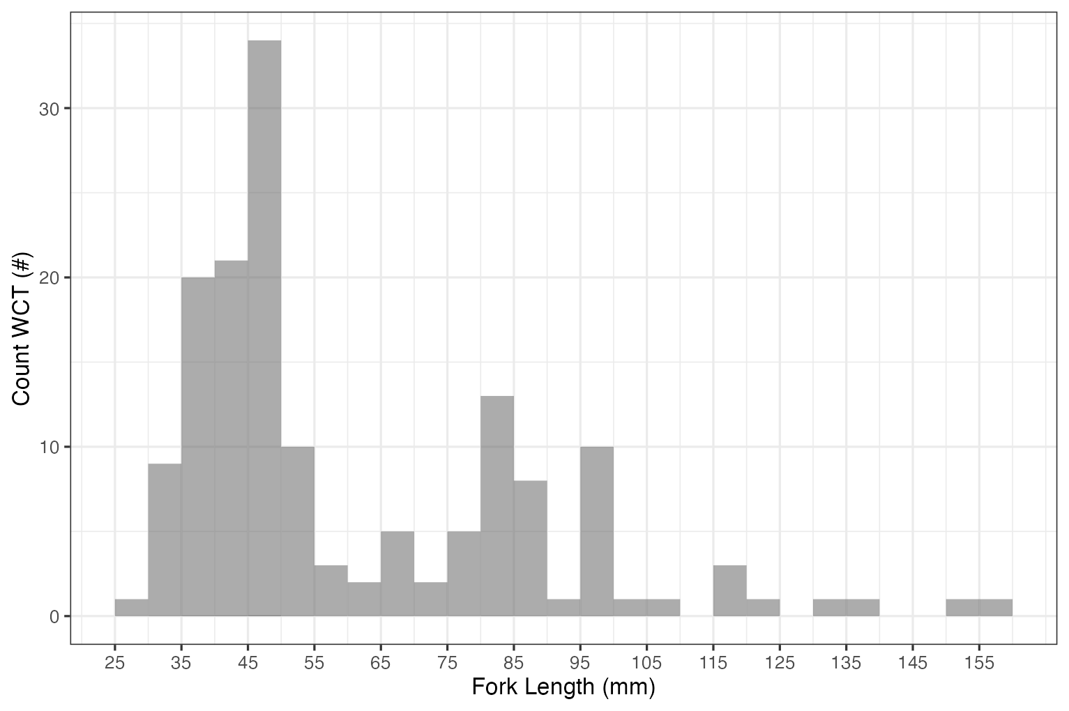
Figure 4.2: Histogram of westslope cutthrout trout captured during electrofishing surveys.
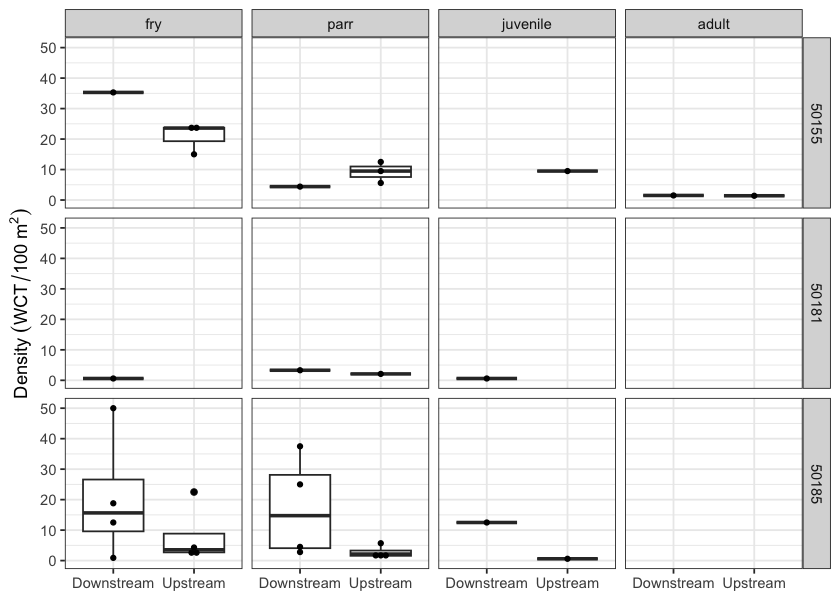
Figure 4.3: Boxplots of densities (fish/100m2) of westslope cutthrout trout captured by life stage and site for data collected during habitat confirmation assessments.