Appendix - 50152 - Tributary to Lizard Creek
Site Location
Crossing 50152 is located on a tributary to Lizard Creek, approximately 140m upstream from the confluence with Lizard Creek and within Mt.Fernie provincial Park. This culvert has also been recorded in PSCIS as crossing 62521. The culvert is located on a paved section of Mt.Fernie Park Road (0.3km mark) and is accessed from Highway 3 within Fernie city limits. The Mt.Fernie Provincial Park is a popular recreational destination for hikers, sightseers and mountain bikers. Island Lake Lodge is located at 1400m of elevation near Island Lake and is a year round tourist destination providing accommodations, guided hiking and backcountry catskiing in the Lizard Creek watershed.
Background
The subject culvert was recently repaired with the work completed including re-profiling the road for safety to improve sightlines for vehicles approaching the campground. This work involved raising the elevation of the road surface and bank stabilization on both sides of the road with washed frac rock. While the work was being conducted, it was determined that the Stove Creek culvert had failed at a coupling joint on the downstream side of the culvert causing erosion and undermining of the culvert. The failed end of the culvert was removed and replaced to remediate the erosion issues (pers comm. Merika Welsh, BC Parks). No fisheries information was available for the stream although Lizard Creek supports westslope cutthroat trout, bull trout, mountain whitefish, brook trout, longnose sucker and longnose dace downstream (MoE 2020d, 2020b). Elk River Alliance (2020) conducted redd surveys in Lizard Creek in 2019 along with Morrissey Creek, Coal Creek and Forsyth Creek. A total of 55 redds were observed within a 2.4km section of Lizard Creek comprising the largest densities of redds of the four tributaries surveyed (22.9 redds/km).
PSCIS stream crossing 50152 was ranked as a high priority for follow up with habitat confirmation due to the large size of the stream recorded in PSCIS (channel width = 2.4m) relative to other tributary streams in the Lizard Creek watershed and because it was rated as containing high value habitat by VAST Resource Solutions Inc. (2013) and Grainger (2011). There is a bridge located on the Lazy Lizard recreation trail approximately 150m upstream of the crossing and an unassessed modelled crossing (ID 4600926) approximately 2100m upstream which could not be accessed due to a road closure. The habitat confirmation was completed on October 16, 2020. A map of the watershed including areas surveyed is provided in Attachment 1 – Map 082G.113.
Stream Characteristics at Crossing
As noted, the culvert located at PSCIS 50152 appeared to have been replaced in 2020 with fresh rock, road fill and pavement present. At the time of the survey, the un-embedded and non-backwatered 0.9m diameter crossing was considered a barrier to upstream fish passage with a pipe length of 30m, a culvert slope of 1.5%, a stream width ratio of 2.9 and an outlet drop of 0.9m (Table 5.1). Water temperature was 5\(^\circ\)C, pH was 8.5 and conductivity was 286uS/cm.
Stream Characteristics Downstream
The stream was surveyed downstream from the culvert for 140m to Lizard Creek. Overall, total cover amount was rated as moderate with undercut banks dominant. Cover was also present as small woody debris, large woody debris, and overhanging vegetation (Table 5.2, Figure 5.1). The average channel width was 2.7m, the average wetted width was 2.1m and the average gradient was 4%. The dominant substrate was cobbles with gravels subdominant. Downstream of the crossing, numerous fry were observed, there were frequent sections of gravels suitable for salmonid spawning and there were no barriers or obstacles to fish passage. Habitat was rated as high value for fry/juvenile salmonid rearing.
Stream Characteristics Upstream
The stream was surveyed upstream from the culvert for 675m. Overall, total cover amount was rated as moderate with undercut banks dominant. Cover was also present as small woody debris, large woody debris, deep pools, and overhanging vegetation (Table 5.2, Figure 5.2). The average channel width was 2.6m, the average wetted width was 2m and the average gradient was 3%. There were numerous fry observed throughout the area surveyed and abundant gravels suitable for resident westslope cutthrout trout spawning were noted. Habitat value was rated as high for salmonid rearing and spawning.
Structure Remediation and Cost Estimate
Structure replacement with a bridge is recommended to provide access to the habitat located upstream of PSCIS crossing 50152. The cost of the work is estimated at $438,000 for a cost benefit of 6.2 linear m/$1000 and 16m2/$1000.
Conclusion
There is 2.7km of mainstem habitat in Stove Creek upstream of crossing 50152 with habitat rated in areas surveyed as high value for fry and juvenile salmonid rearing. Of the four streams surveyed with habitat confirmations in the Lizard Creek drainage during this project, Stove Creek contained the highest value habitat. The large outlet drop (0.9m) on the newly installed culvert prevents upstream migration by all species and life stages. This paved section of road is within Mt.Fernie Provincial Park. The crossing was ranked as a high priority for proceeding to design for replacement.
| Location and Stream Data |
|
Crossing Characteristics | – |
|---|---|---|---|
| Date | 2020-10-16 | Crossing Sub Type | Round Culvert |
| PSCIS ID | 50152 | Diameter (m) | 0.9 |
| External ID | – | Length (m) | 30 |
| Crew | AI, MF | Embedded | No |
| UTM Zone | 11 | Depth Embedded (m) | – |
| Easting | 637987 | Resemble Channel | No |
| Northing | 5483407 | Backwatered | No |
| Stream | Tributary to Lizard Creek | Percent Backwatered | – |
| Road | Mt.Fernie Park Rd | Fill Depth (m) | 5.5 |
| Road Tenure | – | Outlet Drop (m) | 0.9 |
| Channel Width (m) | 2.6 | Outlet Pool Depth (m) | 0.4 |
| Stream Slope (%) | 3 | Inlet Drop | No |
| Beaver Activity | No | Slope (%) | 1.5 |
| Habitat Value | High | Valley Fill | Deep Fill |
Photos: From top left clockwise: Road/Site Card, Barrel, Outlet, Downstream, Upstream, Inlet.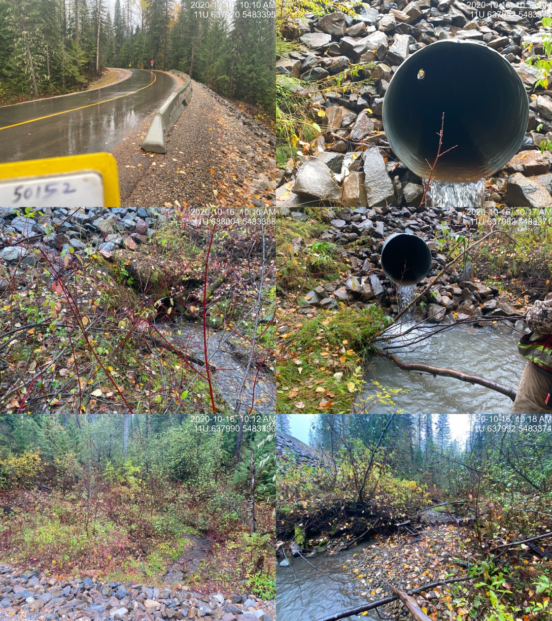
|
| Location | Length Surveyed (m) | Channel Width (m) | Wetted Width (m) | Pool Depth (m) | Gradient (%) | Total Cover | Habitat Value |
|---|---|---|---|---|---|---|---|
| Upstream | 675 | 2.6 | 2 | 0.3 | 3 | moderate | high |
| Downstream | 140 | 2.7 | 2.1 | 0.3 | 4 | moderate | high |
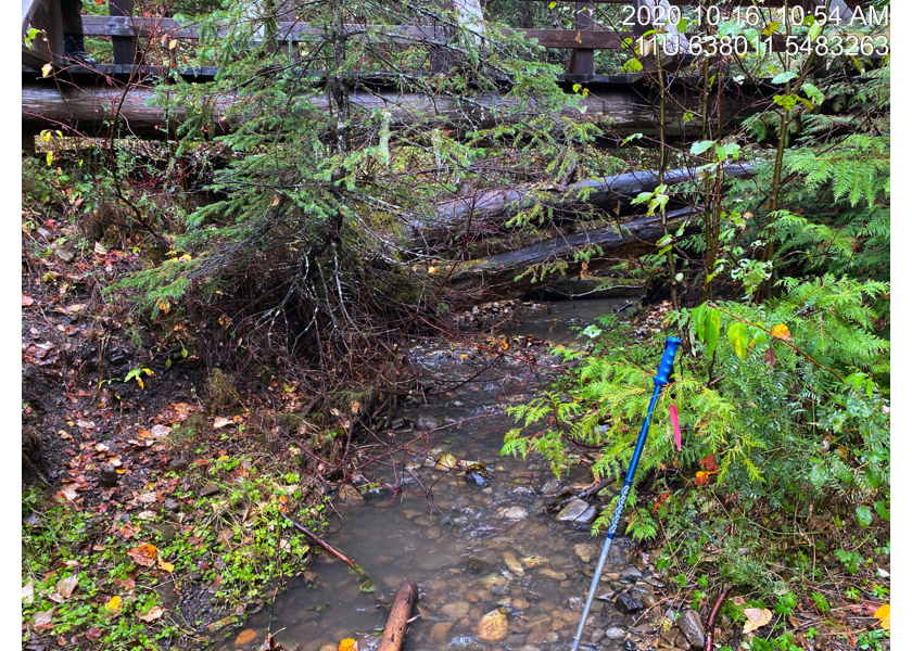
Figure 5.1: Typical habitat downstream of PSCIS crossing 50152.
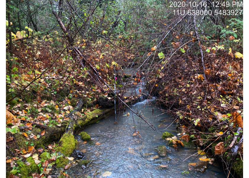
Figure 5.2: Typical habitat upstream of PSCIS crossing 50152.