Tributary To Fraser River - 203581 & 196076 - Appendix
Site Location
PSCIS crossings 203581 and 196076 are located on Tributary To Fraser River , approximately 13km east of Prince George, BC, in the Tabor River watershed group (Figure ??). Crossing 203581 is located 80m upstream of the Fraser River, and is located on and the responsibility of the CN Railway. Approximately 1.3km further upstream, PSCIS crossing 196076 is located on Beaver FSR, and is situated under McLean road tenure R02924 A.
 my_caption <- "Map of Tributary to Fraser River"

 knitr::include_graphics("fig/gis/trib_to_fraser.jpeg")
Background
At the location of these crossings, Tributary To Fraser River is a fourth order stream and drains a watershed of approximately 17.5km2. The watershed ranges in elevation from a maximum of 784m to 592m near the crossing (Table 5.17).
The uppermost crossing, crossing 196076 on Beaver FSR, was previously assessed in 2014 by Hooft (2015) and ranked as a barrier to fish passage with medium value habitat documented. Due to the large amount of chinook and bull trout habitat modelled upstream, the site was reassessed in 2025 along with the previously unassessed downstream CN railway crossing (crossing 203581). Habitat confirmation assessments were completed at both crossings in 2025. No fisheries information is documented for the stream; however, the crossings are near the confluence with the Fraser River, where chinook and bull trout have been recorded.
A summary of habitat modelling outputs for the crossing are presented in Table 5.18.
fpr::fpr_table_wshd_sum(site_id = my_site) |>
  fpr::fpr_kable(caption_text = paste0('Summary of derived upstream watershed statistics for PSCIS crossing ', my_site, '.'),
           footnote_text = 'Elev P60 = Elevation at which 60% of the watershed area is above',
scroll = F)| Site | Area Km | Elev Site | Elev Min | Elev Max | Elev Median | Elev P60 | Aspect |
|---|---|---|---|---|---|---|---|
| 203581 | 17.5 | 592 | 572 | 784 | 688 | 680 | SW |
| * Elev P60 = Elevation at which 60% of the watershed area is above |
| Habitat | Potential | Remediation Gain | Remediation Gain (%) |
|---|---|---|---|
| BT Rearing (km) | 11.6 | 1.4 | 12 |
| BT Spawning (km) | 3.4 | 1.1 | 32 |
| BT Network (km) | 30.3 | 2.4 | 8 |
| BT Stream (km) | 24.1 | 2.1 | 9 |
| BT Lake Reservoir (ha) | 22.2 | 2.6 | 12 |
| BT Wetland (ha) | 40.7 | 0.0 | 0 |
| BT Slopeclass03 (km) | 15.3 | 0.9 | 6 |
| BT Slopeclass05 (km) | 6.8 | 0.6 | 9 |
| BT Slopeclass08 (km) | 1.1 | 0.0 | 0 |
| BT Slopeclass15 (km) | 0.9 | 0.6 | 67 |
| * Model data is preliminary and subject to adjustments. |
Stream Characteristics at Crossings 203581 and 196076
At the time of the 2025 assessment, both PSCIS crossing 203581 and 196076 on Railway were un-embedded, non-backwatered and ranked as a barrier to upstream fish passage according to the provincial protocol (MoE 2011) (Tables 5.19 - 5.20). The downstream crossing on the CN railway (crossing 203581) had a 2.5m outlet drop, however the outlet is directly on the floodplain of the Fraser River and when the river is 2.5 - 3.5m higher the structure would backwater.
Water temperature was 8\(^\circ\)C, pH was 7.6 and conductivity was 489 uS/cm.
| Location and Stream Data |
|
Crossing Characteristics | – |
|---|---|---|---|
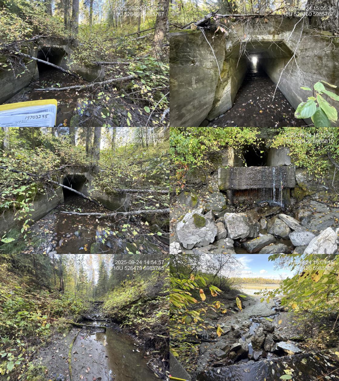
| Date | 2025-09-24 | Crossing Sub Type | Concrete Box |
| PSCIS ID | 203581 | Diameter (m) | 2.1 |
| External ID | 19703295 | Length (m) | 50 |
| Crew | AI | Embedded | No |
| UTM Zone | 10 | Depth Embedded (m) | – |
| Easting | 526469 | Resemble Channel | No |
| Northing | 5985767 | Backwatered | No |
| Stream | Tributary To Fraser River | Percent Backwatered | – |
| Road | Railway | Fill Depth (m) | 9.9 |
| Road Tenure | CN Rail | Outlet Drop (m) | 2.5 |
| Channel Width (m) | 4 | Outlet Pool Depth (m) | 0.1 |
| Stream Slope (%) | 2.5 | Inlet Drop | No |
| Beaver Activity | No | Slope (%) | 2.5 |
| Habitat Value | Medium | Valley Fill | Deep Fill |
| Final score | 37 | Barrier Result | Barrier |
| Fix type | Replace with New Open Bottom Structure | Fix Span / Diameter | 35.5 |
| Comments: Large concrete box structure with the outlet directly on the floodolain of the Fraser River. When the river is 2.5 - 3.5m higher the structure would backwater. Appears that the high watermark is near level with the outlet of the culvert. | |||
| Photos: From top left clockwise: Road/Site Card, Barrel, Outlet, Downstream, Upstream, Inlet. | |||
|
| Location and Stream Data |
|
Crossing Characteristics | – |
|---|---|---|---|
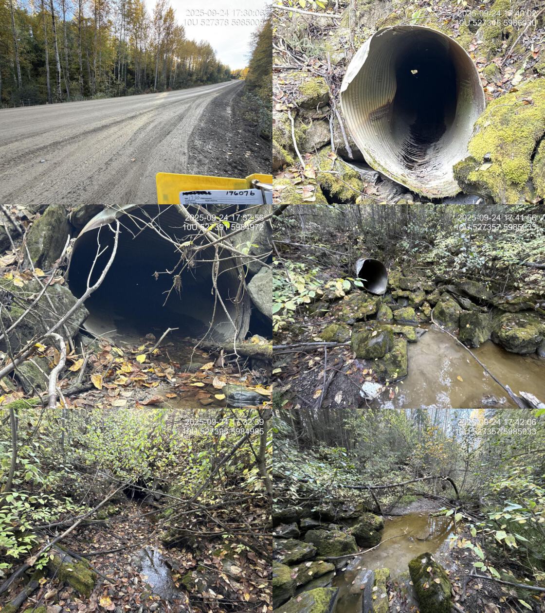
| Date | 2025-09-24 | Crossing Sub Type | Round Culvert |
| PSCIS ID | 196076 | Diameter (m) | 1.2 |
| External ID | – | Length (m) | 50 |
| Crew | AI | Embedded | No |
| UTM Zone | 10 | Depth Embedded (m) | – |
| Easting | 527373 | Resemble Channel | No |
| Northing | 5985002 | Backwatered | No |
| Stream | Tributary To Fraser River | Percent Backwatered | – |
| Road | Beaver FSR | Fill Depth (m) | 4.5 |
| Road Tenure | McLean R02924 A | Outlet Drop (m) | 0.55 |
| Channel Width (m) | 4 | Outlet Pool Depth (m) | 0.1 |
| Stream Slope (%) | 3 | Inlet Drop | No |
| Beaver Activity | Yes | Slope (%) | 2 |
| Habitat Value | Medium | Valley Fill | Deep Fill |
| Final score | 37 | Barrier Result | Barrier |
| Fix type | Replace with New Open Bottom Structure | Fix Span / Diameter | 19.5 |
| Comments: Very long culvert in poor condition, with water flowing out through the eroded pipe bottom rather than the outlet, which landed on a dry boulder riprap cascade. Large beaver dams began approximately 50–100m downstream. Habitat confirmation was conducted upstream and downstream of the crossing, as well as at the railway crossing approximately 1.5km downstream near the Fraser River. | |||
| Photos: From top left clockwise: Road/Site Card, Barrel, Outlet, Downstream, Upstream, Inlet. | |||
|
##this is useful to get some comments for the report
hab_site |>filter(site == my_site & location == 'ds') |>pull(comments)
hab_site |>filter(site == my_site & location == 'us') |>pull(comments)


hab_site |>filter(site == my_site2 & location == 'ds') |>pull(comments)
hab_site |>filter(site == my_site2 & location == 'us') |>pull(comments)
Stream Characteristics Downstream of Crossing 203581
The stream was surveyed downstream from crossing 203581 for 80m (Figure 5.10). The habitat was rated as low value for salmonid spawning and rearing. The outlet of the culvert was directly on the floodplain of the Fraser River. The average channel width was 8.3m, the average wetted width was 1m, and the average gradient was 2.5%.
Stream Characteristics Upstream of Crossing 203581
The stream was surveyed upstream from crossing 203581 for 650m (Figure 5.11). The habitat was rated as medium value. Total cover amount was rated as moderate with small woody debris dominant. Cover was also present as large woody debris, boulders, undercut banks, deep pools, and overhanging vegetation.The average channel width was 4.5m, the average wetted width was 1.9m, and the average gradient was 2.5%.The dominant substrate was gravels with fines sub-dominant. A landslide was located approximately 300m upstream of the railway crossing. The stream was low-gradient with abundant gravels and numerous fish to 60mm observed. The channel flowed through an entrenched, steep-walled valley with several sections where clay banks had collapsed into the stream.
Stream Characteristics Downstream of Crossing 196076
The stream was surveyed downstream from crossing 196076 for 250m (Figure 5.12). The habitat was rated as medium value. Beaver dams ranging from 0.6–1m in height began approximately 150m downstream of the culvert within an incised gully. Upstream of the dams, abundant gravels, shallow pools, and small woody debris provided habitat suitable for parr and juvenile rearing. Total cover amount was rated as moderate with deep pools dominant. Cover was also present as small woody debris, undercut banks, and overhanging vegetation.The dominant substrate was NA with NA sub-dominant.The average channel width was 7m, the average wetted width was 5.7m, and the average gradient was 3%.
Stream Characteristics Upstream of Crossing 196076
The stream was surveyed upstream from crossing 196076 for 700m (Figure 5.13). The habitat was rated as medium value. Total cover amount was rated as moderate with undercut banks dominant. Cover was also present as small woody debris, deep pools, and overhanging vegetation.The dominant substrate was NA with NA sub-dominant.The average channel width was 3.5m, the average wetted width was 2.1m, and the average gradient was 2.8%. The stream was moderate-sized, low-gradient stream with abundant gravels and habitat suitable for fry and juvenile salmonid rearing, including shallow pools, small and large woody debris, and undercut banks. No fish or barriers were observed at the time of assessment.
Environmental DNA Sampling
Two eDNA samples were collected upstream of crossing 203581 on the CN railway using different pore sizes. Two samples were also collected downstream of crossing 196076 on Beaver FSR, positioned upstream of the lowest beaver dam. Fish were observed downstream of the lowest beaver dam ~500m from the Fraser River; samples were therefore collected to assess whether fish could be detected upstream of the dams but downstream of the FSR. Filtering rates were extremely slow, requiring a second filter. One additional sample was collected upstream of 196076 on Beaver FSR. Sampling techniques are summarized in Table 5.21.
my_caption <- paste0("Summary of eDNA samples collected at sites ", my_site, " and ", my_site2, ".")

tab_edna |>
  dplyr::filter(site %in% c(my_site, my_site2)) |>
  ## Unique to fraser 2025 - renaming sites to match the new pscis IDs, I didnt want to change the site names in the actually form because those are associated with the samples that got sent to the lab, and didn't want to cause any confusion.
  tidyr::separate(Site, into = c("site", "location", "ed"), remove = FALSE) |>
  dplyr::mutate(site = dplyr::case_when(stringr::str_detect(ed, "ed1a|ed1b") ~ "203581", T ~ site)) |>
  dplyr::mutate(location = dplyr::case_when(stringr::str_detect(ed, "ed1a|ed1b") ~ "us", T ~ location)) |>
  dplyr::mutate(Site = paste0(site, "_", location, "_", ed)) |>
  dplyr::select(-c(site, location, ed)) |>
  dplyr::arrange(Site) |>
  ## END hack
  # dplyr::select(-site) |>
fpr_kable(caption_text = my_caption, scroll = FALSE)| Site | Stream | Habitat Type | Sample Method | Filter Type | Filter Size (um) | Volume filtered (L) | Site Description |
|---|---|---|---|---|---|---|---|
| 196076_ds_ed2a | Tributary To Fraser River | pool | instream | mce | 1.00 | 1.3 | 150m downstream of culvert on Beaver FSR upstream of first beaver dam (from culvert downstream). |
| 196076_ds_ed2b | Tributary To Fraser River | pool | instream | mce | 1.00 | 1.6 | 150m downstream of culvert on Beaver FSR upstream of first beaver dam (from culvert downstream). |
| 196076_us_ed1 | Tributary To Fraser River | pool | instream | mce | 1.00 | 2.0 | 10 m upstream of culvert inlet in pool. Too shallow to sample riffle soul sample top end of shallow pool. Right bank |
| 203581_us_ed1a | Tributary To Fraser River | – | grab | mce | 0.45 | 1.0 | 20m upstream of railway culvert |
| 203581_us_ed1b | Tributary To Fraser River | – | grab | mce | 1.50 | 1.0 | 20m upstream of railway culvert |
Structure Remediation and Cost Estimate
Should restoration/maintenance activities proceed, replacement of the CN Railway crossing (203581) with a bridge (35.5m span) is recommended. At the time of reporting in 2025, the cost of the work is estimated at $26,625,000.
Should restoration/maintenance activities proceed at the Beaver FSR crossing (196076) replacement with a bridge (19.5 m span) is recommended. At the time of reporting in 2025, the cost of the work is estimated at $585,000.
Conclusion
Tributary To Fraser River provided medium value habitat for salmonid spawning and rearing. The downstream railway crossing is ranked as a low priority for replacement because the structure is likely backwatered when the Fraser River is higher. The upstream crossing on Beaver FSR had a significant outlet drop and is ranked as a moderate priority for replacement. Crossing 196076 on Beaver FSR could be a strong candidate for replacement because the site is close to the Fraser River, is in close proximity to the City of Prince George (supporting community engagement opportunities), and is located on an active logging road, providing potential for collaborative remediation with the road tenure holder McLean.
tab_hab_summary |>
  dplyr::filter(Site %in% c(my_site, my_site2)) |>
  fpr::fpr_kable(caption_text = paste0("Summary of habitat details for PSCIS crossings ", my_site, " and ", my_site2, "."),
scroll = F) | Site | Location | Length Surveyed (m) | Average Channel Width (m) | Average Wetted Width (m) | Average Pool Depth (m) | Average Gradient (%) | Total Cover | Habitat Value |
|---|---|---|---|---|---|---|---|---|
| 196076 | Downstream | 250 | 7.0 | 5.7 | 0.4 | 3.0 | moderate | medium |
| 196076 | Upstream | 700 | 3.5 | 2.1 | 0.4 | 2.8 | moderate | medium |
| 203581 | Downstream | 80 | 8.3 | 1.0 | – | 2.5 | – | – |
| 203581 | Upstream | 650 | 4.5 | 1.9 | 0.3 | 2.5 | moderate | medium |
my_photo1 = fpr::fpr_photo_pull_by_str(str_to_pull = 'ds_typical_2_')

my_caption1 = paste0('Typical habitat downstream of PSCIS crossing ', my_site, '.')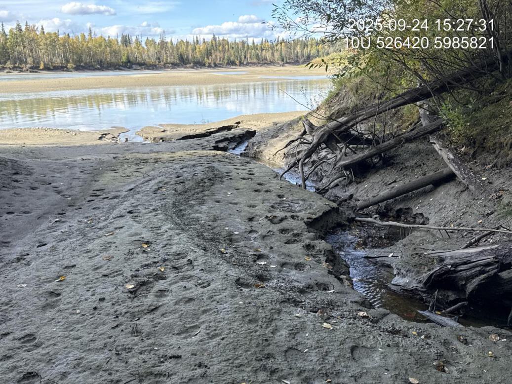
Figure 5.10: Typical habitat downstream of PSCIS crossing 203581.
my_photo2 = fpr::fpr_photo_pull_by_str(str_to_pull = 'us_typical_1_')

my_caption2 = paste0('Typical habitat upstream of PSCIS crossing ', my_site, '.')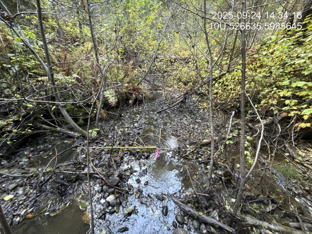
Figure 5.11: Typical habitat upstream of PSCIS crossing 203581.
my_caption <- paste0('Left: ', my_caption1, ' Right: ', my_caption2)

knitr::include_graphics(my_photo1)
knitr::include_graphics("fig/pixel.png")
knitr::include_graphics(my_photo2)
my_photo1 = fpr::fpr_photo_pull_by_str(site = my_site2, str_to_pull = 'ds_typical_1_')
my_caption1 = paste0('Beaver dam complex located downstream of PSCIS crossing ', my_site2, '.')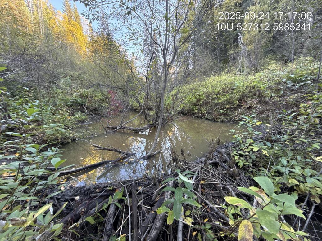
Figure 5.12: Beaver dam complex located downstream of PSCIS crossing 196076.
my_photo2 = fpr::fpr_photo_pull_by_str(site = my_site2, str_to_pull = 'us_typical_2_')

my_caption2 = paste0('Typical habitat upstream of PSCIS crossing ', my_site2, '.')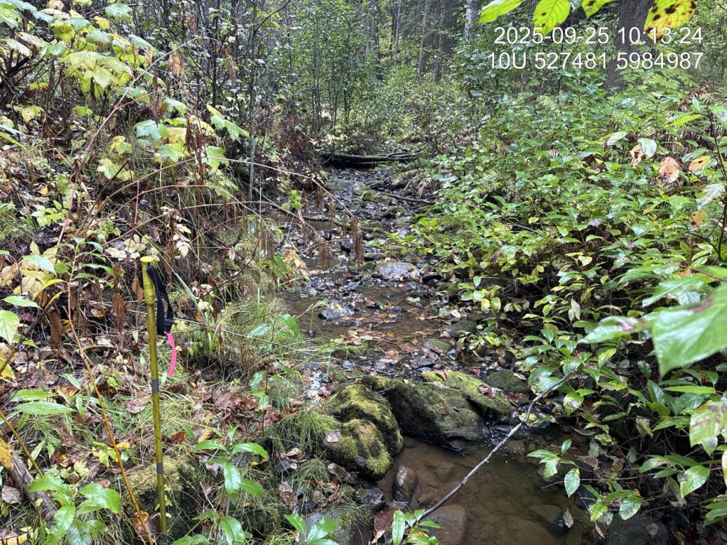
Figure 5.13: Typical habitat upstream of PSCIS crossing 196076.