Tributary to the Table River - 125231 - Monitoring Appendix
Effectiveness monitoring was conducted in 2025 at PSCIS crossing 125231 on the Chuchinka-Table FSR. Site location, background, and the 2023 replacement of the crossing with a clear-span bridge by Canfor (with engineering oversight by DWB Consulting Services Ltd. and 50% funding from FWCP via SERNbc coordination) are documented in Irvine and Winterscheidt (2024); the 2023 site appendix is available at https://www.newgraphenvironment.com/fish_passage_peace_2023_reporting/tributary-to-the-table-river—125231—appendix.html.
Monitoring Form
2025 effectiveness monitoring form results are summarized in Table 5.39.
tab_monitoring |>
  dplyr::filter(`Pscis Crossing Id` == my_site) |>
  dplyr::mutate(across(everything(), as.character)) |>
  tidyr::pivot_longer(
    cols = everything(),
    names_to = "Variable",
    values_to = "Value"
  ) |>
  fpr::fpr_kable(
    caption_text = paste0("Summary of effectiveness monitoring form results for site ", my_site, " in ", params$project_year, "."),
    scroll = gitbook_on
)| Variable | Value |
|---|---|
| Pscis Crossing Id | 125231 |
| Stream Name | Tributary to Table River |
| Road Name | Table FSR |
| Crossing Subtype | BRIDGE |
| Span | – |
| Width | – |
| Assessment Comment | Overall, the site looks very similar to last year, in good condition with no evidence of any structural issues and the instream portion doing quite well. As there is a large amount of rock rip wrap adjacent to the stream that was not planted the riparian vegetation within the footprint is basically nonexistent. Electrofishing was conducted at sites downstream and upstream of the bridge with fish over 65mm PIT tagged. eDNA samples were collected as well. |
| Dewatering Notes | No degrading of the channel noted. Good flow throughout construction footprint. |
| Velocity Notes | Velocities in the construction footprint are similar to upstream and downstream with maturing stone lines and placed boulders, stepping out the gradient to natural conditions |
| Constriction Notes | Width of channel appears similar to upstream and downstream with room for channel migration. |
| Substrate Notes | Substrate is very similar to upstream and downstream with well placed riprap and boulders providing scour and creating pool habitat. |
| Riparian Notes | Basically no riparian regrowth within the construction footprint due to large amount of rip wrap placed. |
| Flow Depth Notes | Flow depths are acceptable with deep sections adjacent to stone lines and placed boulders. |
| Stability Notes | Structure appears stable with no evidence of any movement |
| Revegetation Notes | Revegetation of the site is generally poor due to the large amount of rock placed in the construction footprint and a lack of planting and seeding. |
| Cover Notes | Cover is available adjacent to stone lines and placed boulders were scour and some shallow pools have been created. Fish were captured in these areas within the construction footprint, indicating that they are providing suitable habitat for local fish species. |
| Maintenance Notes | No maintenance required |
Fish Sampling
Electrofishing was conducted downstream and upstream of PSCIS crossing 125231 in 2025. Per-site capture results are in Table 5.40; densities are in Table 5.41 and Figure 5.33.
| site | passes | ef_length_m | ef_width_m | area_m2 | enclosure |
|---|---|---|---|---|---|
| 125231_ds_ef1 | 1 | 50 | 2.8 | 140 | partial enclosure |
| 125231_us_ef1 | 1 | 50 | 1.6 | 80 | partial enclosure |
| local_name | species_code | life_stage | catch | density_100m2 | nfc_pass |
|---|---|---|---|---|---|
| 125231_ds_ef1 | Rainbow Trout | adult | 1 | 0.7 | FALSE |
| 125231_ds_ef1 | Rainbow Trout | fry | 7 | 5.0 | FALSE |
| 125231_ds_ef1 | Rainbow Trout | juvenile | 1 | 0.7 | FALSE |
| 125231_ds_ef1 | Rainbow Trout | parr | 5 | 3.6 | FALSE |
| 125231_us_ef1 | Rainbow Trout | adult | 1 | 1.2 | FALSE |
| 125231_us_ef1 | Rainbow Trout | fry | 5 | 6.2 | FALSE |
| 125231_us_ef1 | Rainbow Trout | juvenile | 3 | 3.8 | FALSE |
| 125231_us_ef1 | Rainbow Trout | parr | 2 | 2.5 | FALSE |
| 125231_us_ef1 | Sucker (General) | adult | 1 | 1.2 | FALSE |
|
* nfc_pass FALSE means fish were captured in final pass indicating more fish of this species/lifestage may have remained in site. Mark-recaptured required to reduce uncertainties. |
my_caption <- paste0('Densities of fish (fish/100m2) captured upstream and downstream of PSCIS crossing ', my_site, ' in ', params$project_year, '.')

fish_abund |>
  dplyr::filter(site == my_site, species_code != "NFC") |>
  ggplot2::ggplot(ggplot2::aes(x = location, y = density_100m2, color = local_name, fill = local_name)) +
  ggplot2::geom_boxplot(fill = "lightgray", color = "black", alpha = 0.7) +
  ggplot2::geom_dotplot(binaxis = "y", stackdir = "center", dotsize = 0.8) +
  ggplot2::facet_grid(. ~ life_stage, scales = "fixed") +
  ggplot2::theme_light() +
  ggplot2::theme(
    legend.position = "right",
    axis.title.x = ggplot2::element_blank()
  ) +
  ggplot2::ylab(expression(Density ~ (fish/100 ~ m^2)))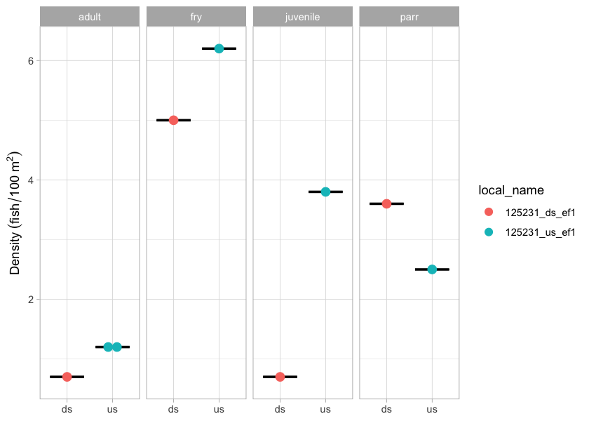
Figure 5.33: Densities of fish (fish/100m2) captured upstream and downstream of PSCIS crossing 125231 in 2025.
Environmental DNA
eDNA samples were collected upstream and downstream of PSCIS crossing 125231 in 2025 as part of the program-wide eDNA sampling effort. Per-position detection results are presented in Table 5.42. Detections are based on the standard ddPCR call threshold of ≥4 positive droplets; format is CODE(max_droplets), with * flagging samples UNBC reran. Site-level detail across all sampled crossings is in Appendix - Environmental DNA Results, and the interactive Peace eDNA map provides a toggleable per-species view.
edna_results_125231_mon |>
  fpr::fpr_kable(
    caption_text = paste0("eDNA detection results at crossing ", my_site, "."),
    scroll = FALSE
)| Site ID | UNBC ID | Detected | Sub-threshold | Not detected |
|---|---|---|---|---|
| 125231_ds_ed1c | M41356 | RAIN(205) | — | BULT(0), GRAY(0), SOCK(0) |
| 125231_us_ed1 | M41357 | RAIN(5) | — | BULT(0), GRAY(0), SOCK(0) |
Conclusion
At the time of reporting, the structure at PSCIS crossing 125231 appears stable and the site is showing positive signals of recovery. Continued effectiveness monitoring at this site is recommended in future years to extend the multi-year time series of structure performance and fish use.