Tributary To Parsnip River - 199663 - Appendix
Site Location
PSCIS crossing 199663 is located on Tributary To Parsnip River, approximately 20km northeast of community of McLeod Lake, BC, in the Parsnip River watershed group (Figure 5.22). The crossing is located 780m upstream of the stream’s confluence with the Parsnip River on Chco 12000 road which is the responsibility of BC Timber Sales.
 my_caption <- "Map of Tributary To Parsnip River"

 knitr::include_graphics("fig/gis/map_trib_to_parsnip.jpeg")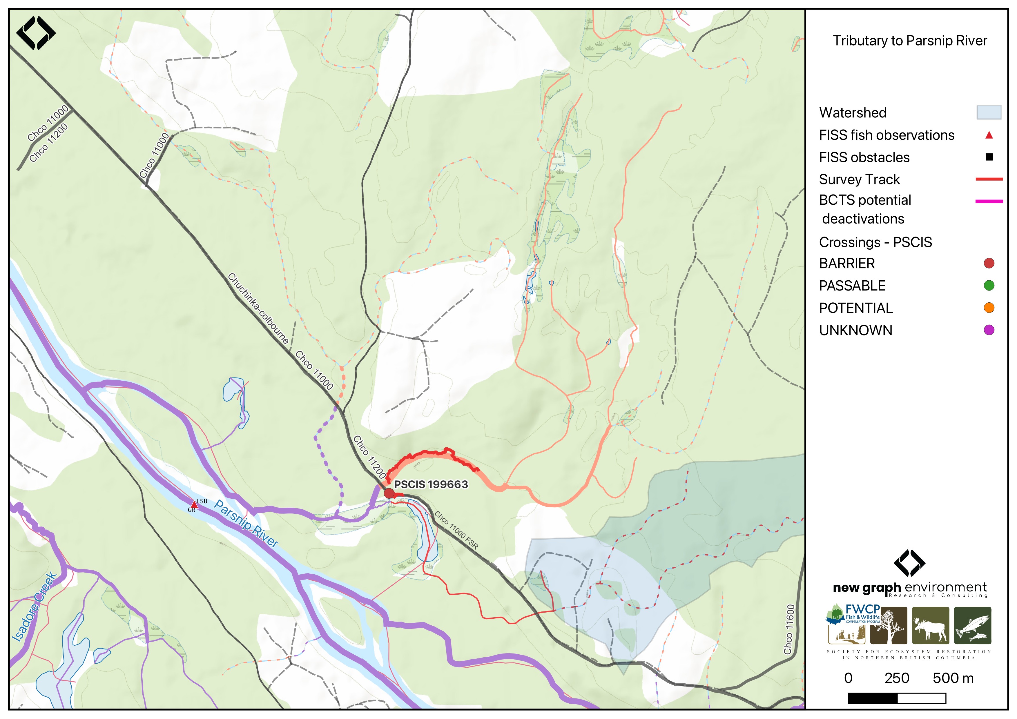
Figure 5.22: Map of Tributary To Parsnip River
Background
At PSCIS crossing 199663, Tributary To Parsnip River is a third order stream and drains a watershed of approximately 1km2. The watershed ranges in elevation from a maximum of 849m to 713m near the crossing (Table 5.17).
PSCIS crossing 199663 was first assessed in 2024 as part of this project and was ranked as a barrier to fish passage with medium value habitat documented (Irvine and Schick 2025). The crossing was reassessed in 2025, and a habitat confirmation was completed due to the presence of medium value habitat and a significant outlet drop at the culvert. Just upstream of the confluence of this tributary and the Parsnip River, grayling have been documented (Norris [2018] 2024; MoE 2024a).
A summary of habitat modelling outputs for the crossing are presented in Table 5.18.
fpr::fpr_table_wshd_sum(site_id = my_site) |>
  fpr::fpr_kable(caption_text = paste0('Summary of derived upstream watershed statistics for PSCIS crossing ', my_site, '.'),
           footnote_text = 'Elev P60 = Elevation at which 60% of the watershed area is above',
scroll = F)| Site | Area Km | Elev Site | Elev Min | Elev Max | Elev Median | Elev P60 | Aspect |
|---|---|---|---|---|---|---|---|
| 199663 | 1 | 713 | 707 | 849 | 784 | 774 | SW |
| * Elev P60 = Elevation at which 60% of the watershed area is above |
| Habitat | Potential | Remediation Gain | Remediation Gain (%) |
|---|---|---|---|
| BT Rearing (km) | 1.6 | 1.6 | 100 |
| BT Spawning (km) | 0.7 | 0.7 | 100 |
| BT Network (km) | 9.9 | 9.3 | 94 |
| BT Stream (km) | 8.0 | 7.4 | 92 |
| BT Lake Reservoir (ha) | 0.5 | 0.5 | 100 |
| BT Wetland (ha) | 12.8 | 12.8 | 100 |
| BT Slopeclass03 (km) | 3.6 | 3.0 | 83 |
| BT Slopeclass05 (km) | 3.6 | 3.6 | 100 |
| BT Slopeclass08 (km) | 0.9 | 0.9 | 100 |
| BT Slopeclass15 (km) | 0.2 | 0.2 | 100 |
| * Model data is preliminary and subject to adjustments. |
Stream Characteristics at Crossing 199663
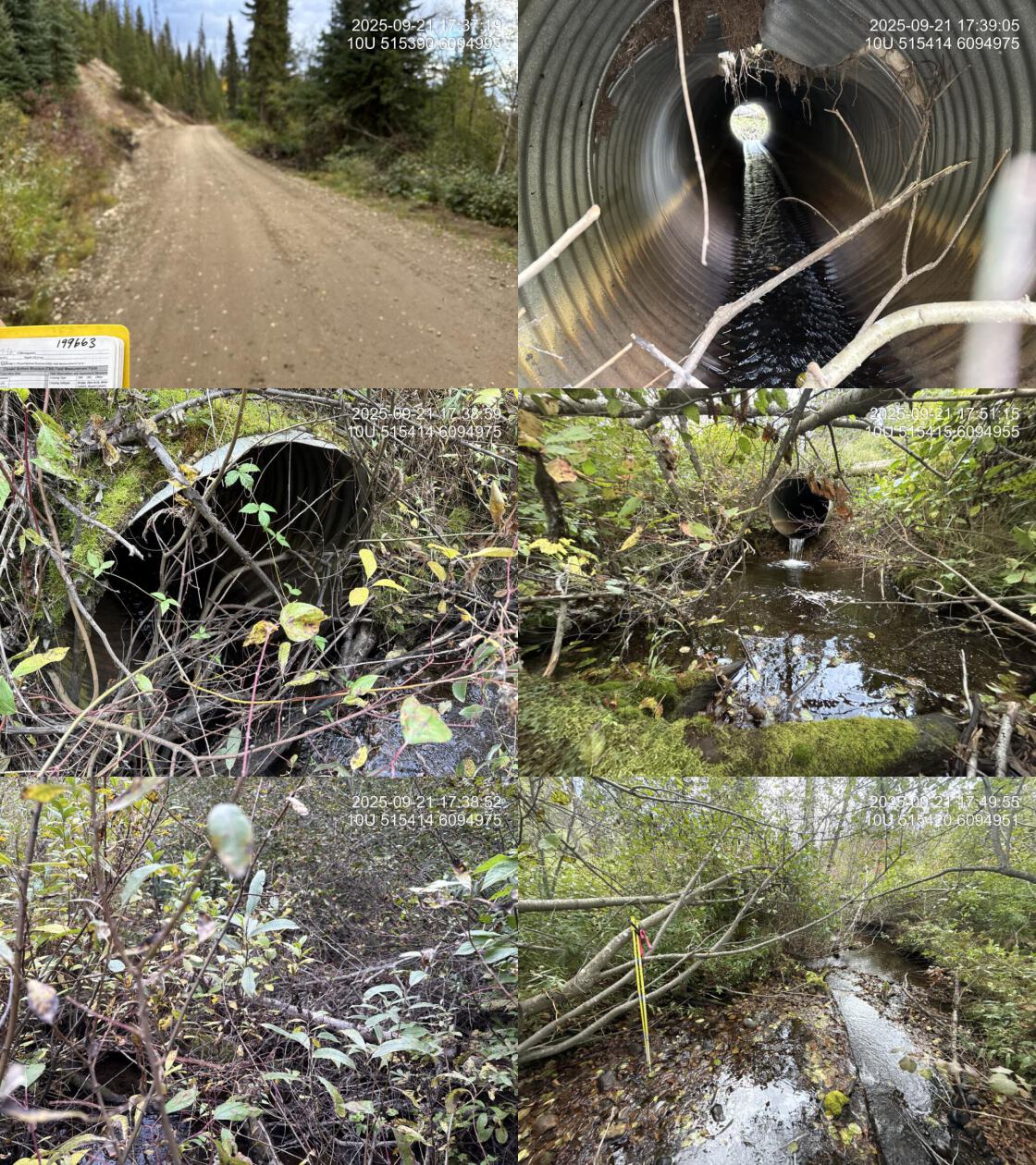
At the time of the 2025 assessment, PSCIS crossing 199663 on Chco 12000 was un-embedded, non-backwatered and ranked as barrier to upstream fish passage according to the provincial protocol (MoE 2011) (Table 5.19). The culvert had a 0.6m outlet drop and a 0.4m deep outlet pool.
The water temperature was 7\(^\circ\)C, pH was 8.2 and conductivity was 310 uS/cm.
| Location and Stream Data |
|
Crossing Characteristics | – |
|---|---|---|---|
| Date | 2025-09-21 | Crossing Sub Type | Round Culvert |
| PSCIS ID | 199663 | Diameter (m) | 1.2 |
| External ID | – | Length (m) | 13 |
| Crew | AI | Embedded | No |
| UTM Zone | 10 | Depth Embedded (m) | – |
| Easting | 515416 | Resemble Channel | – |
| Northing | 6094963 | Backwatered | No |
| Stream | Tributary To Parsnip River | Percent Backwatered | – |
| Road | Chco 12000 | Fill Depth (m) | 0.5 |
| Road Tenure | BCTS | Outlet Drop (m) | 0.6 |
| Channel Width (m) | 0 | Outlet Pool Depth (m) | 0.4 |
| Stream Slope (%) | 1 | Inlet Drop | No |
| Beaver Activity | No | Slope (%) | 3 |
| Habitat Value | Medium | Valley Fill | Deep Fill |
| Final score | 30 | Barrier Result | Barrier |
| Fix type | Replace Structure with Streambed Simulation CBS | Fix Span / Diameter | 3 |
| Comments: Only photos and downstream width measurements were collected in 2025 due to limited time; all other information was transcribed from the 2024 survey. Habitat confirmations and eDNA samples were collected both upstream and downstream. A large wetland was located approximately 70–80m downstream of the culvert outlet. Abundant gravels were present within the first 20–30m below the outlet pool, where flow was strong, and a substantial outlet drop was observed. | |||
| Photos: From top left clockwise: Road/Site Card, Barrel, Outlet, Downstream, Upstream, Inlet. | |||
|
Stream Characteristics Downstream of Crossing 199663
The stream was surveyed downstream from crossing 199663 for 80m (Figure 5.23). The habitat was rated as medium value for salmonid spawning and rearing. The stream had good flow and abundant gravels for 30–40m downstream of the culvert. A wetland was located ~80m downstream of the FSR. The average channel width was 2.6m and the average wetted width was 2.8m. The dominant substrate was cobbles with gravels sub-dominant.Total cover amount was rated as abundant with deep pools dominant. Cover was also present as small woody debris, large woody debris, undercut banks, and overhanging vegetation.
Stream Characteristics Upstream of Crossing 199663
The stream was surveyed upstream from crossing 199663 for 600m (Figure 5.24). The habitat was rated as medium value. The average channel width was 3m, the average wetted width was 2.1m, and the average gradient was 2.8%.The dominant substrate was fines with gravels sub-dominant.Total cover amount was rated as abundant with overhanging vegetation dominant. Cover was also present as small woody debris, large woody debris, and undercut banks. The stream was low gradient with significant riparian tree blowdown throughout. Wide floodplain within a well defined canyon (approximately 15m deep with slopes of ~45°). Healthy riparian consisting of herb and shrub cover within sparse spruce forest that appears to have been impacted by some sort of beetle or other affliction. Most of the spruce trees were dead with many already fallen down.
##this is useful to get some comments for the report
form_edna |>filter(site == my_site & location == 'ds') |>pull(comments_field)
form_edna |>filter(site == my_site & location == 'ds') |>pull(comments_lab)


form_edna |>filter(site == my_site & location == 'us') |>pull(comments_field)
form_edna |>filter(site == my_site & location == 'us') |>pull(comments_lab)

# form_edna |>filter(site == my_site2 & location == 'ds') |>pull(comments_field)
# form_edna |>filter(site == my_site2 & location == 'ds') |>pull(comments_lab)
#
#
# form_edna |>filter(site == my_site2 & location == 'us') |>pull(comments_field)
# form_edna |>filter(site == my_site2 & location == 'us') |>pull(comments_lab)
Environmental DNA
eDNA samples were collected both upstream and downstream of crossing 199663 on Chco 12000, with sampling techniques summarized in Table 5.20. Samples were submitted to UNBC for ddPCR analysis against Bull Trout, Arctic Grayling, Rainbow Trout, Kokanee, and Burbot assays (Burbot was tested only at this crossing among the Peace 2025 sites). Per-position results are summarized in Table 5.21. Detections are based on the standard ddPCR call threshold of ≥4 positive droplets; format is CODE(max_droplets), with * flagging samples UNBC reran.
Site-level detail across all sampled crossings is in Appendix - Environmental DNA Results. as well as within the interactive Peace eDNA map.
my_caption <- paste0("Summary of eDNA samples collected at site ", my_site, ".")

tab_edna |>
  dplyr::filter(site == my_site) |>
  dplyr::select(-site) |>
    dplyr::arrange(Site) |>
fpr_kable(caption_text = my_caption, scroll = FALSE)| Site | Stream | Habitat Type | Sample Method | Filter Type | Filter Size (um) | Volume filtered (L) | Site Description |
|---|---|---|---|---|---|---|---|
| 199663_ds_ed1 | Tributary To Parsnip River | riffle | instream | mce | 1 | 2.0 | Sample collected 15m downstream of culvert right bank. Site was chosen close to the culvert because of the wetland that was just downstream of this area - and wanted some flow. |
| 199663_us_ed1 | Tributary To Parsnip River | riffle | instream | mce | 1 | 2.9 | Sample collected 25m upstream of culvert inlet on the right bank |
edna_results_199663 |>
  fpr::fpr_kable(
    caption_text = paste0("eDNA detection results at crossing ", my_site, "."),
    scroll = FALSE
)| Site ID | UNBC ID | Detected | Sub-threshold | Not detected |
|---|---|---|---|---|
| 199663_ds_ed1 | M10139 | BURB(195), RAIN(112) | — | BULT(0), GRAY(0) |
| 199663_us_ed1 | M10140 | RAIN(65) | — | BULT(0), BURB(0), GRAY(0) |
Structure Remediation and Cost Estimate
Should restoration/maintenance activities proceed, replacement of the Chco 12000 crossing (199663) with a streambed simulation (3m span) is recommended. At the time of reporting in 2026, the cost of the work is estimated at $300,000.
Conclusion
The habitat upstream of PSCIS crossing 199663 on Chco 12000 was documented as medium value for salmonid spawning and rearing, and the crossing is rated as a moderate priority for replacement due to the large outlet drop. Environmental DNA sampling at the site confirmed rainbow trout both upstream and downstream of the crossing; no bull trout were detected. Burbot were detected downstream but not upstream.
Since the assessment season, the FWCP 2026 proposal for replacement of this crossing was accepted and 50% project funding is confirmed. Replacement is targeted for 2026 in coordination with BC Timber Sales; an engineering firm is expected to collect the data required for the site plan.
tab_hab_summary |>
  dplyr::filter(Site %in% c(my_site)) |>
  fpr::fpr_kable(caption_text = paste0("Summary of habitat details for PSCIS crossing ", my_site, "."),
scroll = F) | Site | Location | Length Surveyed (m) | Average Channel Width (m) | Average Wetted Width (m) | Average Pool Depth (m) | Average Gradient (%) | Total Cover | Habitat Value |
|---|---|---|---|---|---|---|---|---|
| 199663 | Downstream | 80 | 2.6 | 2.8 | – | – | abundant | – |
| 199663 | Upstream | 600 | 3.0 | 2.1 | 0.2 | 2.8 | abundant | medium |
my_photo1 = fpr::fpr_photo_pull_by_str(str_to_pull = 'ds_typical_2_')

my_caption1 = paste0('Typical habitat downstream of PSCIS crossing ', my_site, '.')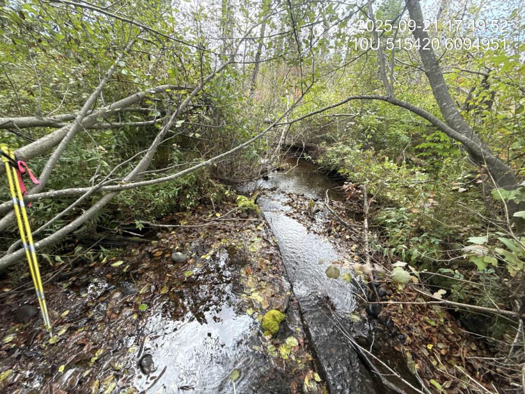
Figure 5.23: Typical habitat downstream of PSCIS crossing 199663.
my_photo2 = fpr::fpr_photo_pull_by_str(str_to_pull = 'us_typical_1_')

my_caption2 = paste0('Typical habitat upstream of PSCIS crossing ', my_site, '.')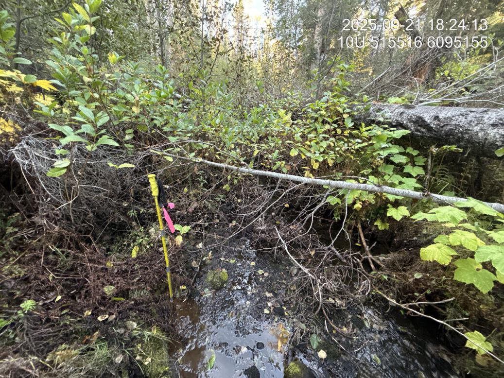
Figure 5.24: Typical habitat upstream of PSCIS crossing 199663.
my_caption <- paste0('Left: ', my_caption1, ' Right: ', my_caption2)

knitr::include_graphics(my_photo1)
knitr::include_graphics("fig/pixel.png")
knitr::include_graphics(my_photo2)