Tributary To Nation River - 203597 - Appendix
Site Location
PSCIS crossing 203597 is located on Tributary To Nation River, approximately 65km west of McKenzie, BC, as the crow flies, and is in the Nation River watershed group (Figure 5.25). The crossing is located 1.9m upstream of the stream’s confluence with the Nation River on Thut 15000 road and is situated under Sekani Forest Products Ltd. road tenure R07214 8.
 my_caption <- "Map of Tributary To Nation River"

 knitr::include_graphics("fig/gis/map_trib_to_nation.jpeg")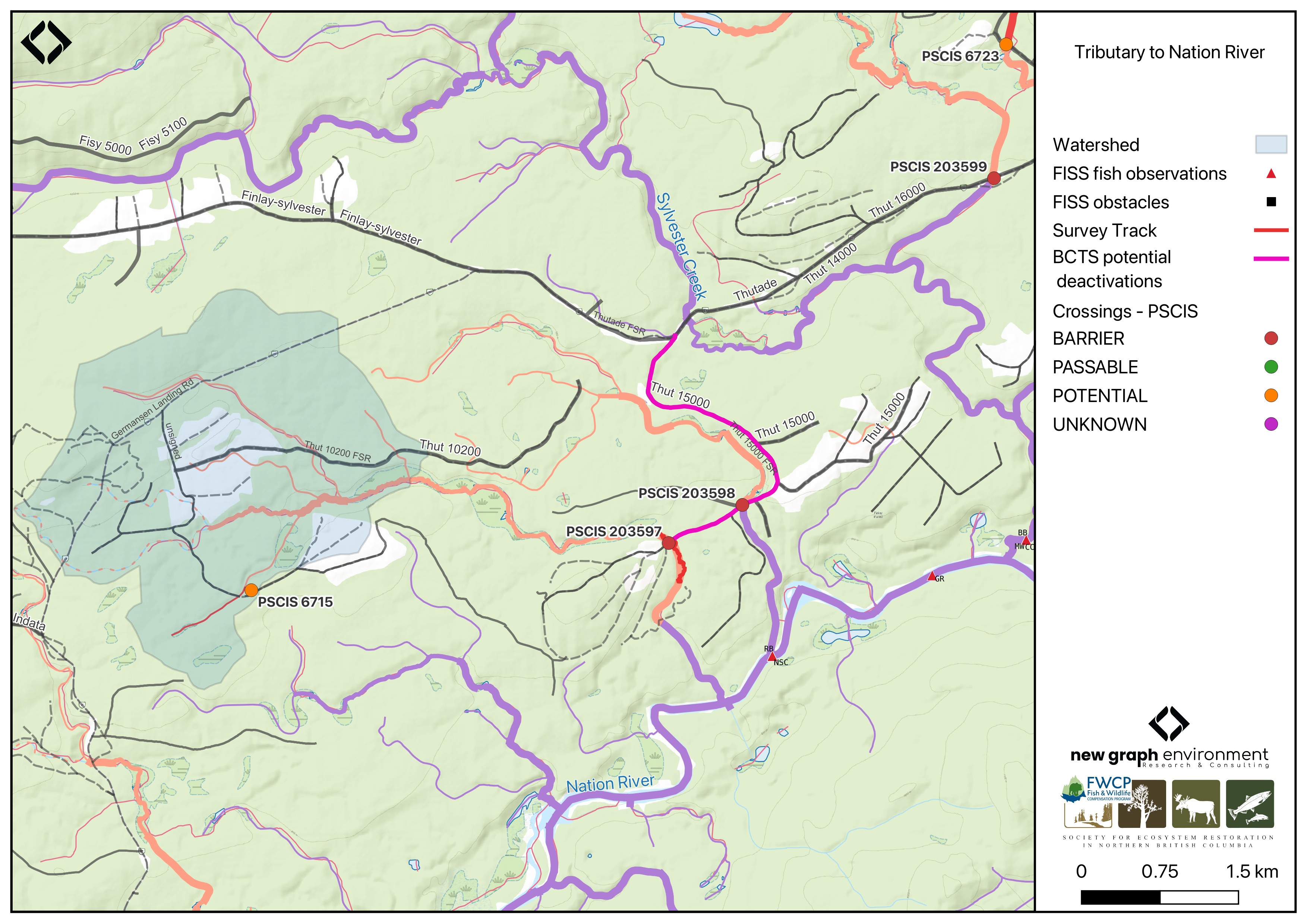
Figure 5.25: Map of Tributary To Nation River
Background
At PSCIS crossing 203597, Tributary To Nation River is a second order stream and drains a watershed of approximately 8.2km2. The watershed ranges in elevation from a maximum of 1065m to 900m near the crossing (Table 5.23).
This was the first assessment of PSCIS crossing 203597, in part because the site is situated on a road identified by BC Timber Sales as a potential deactivation candidate. The stream exhibited high-quality habitat, so a habitat confirmation was completed. Bull trout are documented in the Nation River near the confluence with this stream (Norris [2018] 2024; MoE 2024a).
A summary of habitat modelling outputs for the crossing are presented in Table 5.24.
fpr::fpr_table_wshd_sum(site_id = my_site) |>
  fpr::fpr_kable(caption_text = paste0('Summary of derived upstream watershed statistics for PSCIS crossing ', my_site, '.'),
           footnote_text = 'Elev P60 = Elevation at which 60% of the watershed area is above',
scroll = F)| Site | Area Km | Elev Site | Elev Min | Elev Max | Elev Median | Elev P60 | Aspect |
|---|---|---|---|---|---|---|---|
| 203597 | 8.2 | 900 | 907 | 1065 | 980 | 971 | S |
| * Elev P60 = Elevation at which 60% of the watershed area is above |
| Habitat | Potential | Remediation Gain | Remediation Gain (%) |
|---|---|---|---|
| BT Rearing (km) | 5.6 | 5.6 | 100 |
| BT Spawning (km) | 0.7 | 0.7 | 100 |
| BT Network (km) | 16.8 | 9.5 | 57 |
| BT Stream (km) | 12.2 | 5.2 | 43 |
| BT Lake Reservoir (ha) | 1.0 | 1.0 | 100 |
| BT Wetland (ha) | 47.1 | 46.2 | 98 |
| BT Slopeclass03 (km) | 7.9 | 2.5 | 32 |
| BT Slopeclass05 (km) | 4.0 | 2.5 | 62 |
| BT Slopeclass08 (km) | 0.5 | 0.5 | 100 |
| BT Slopeclass15 (km) | 0.0 | 0.0 | – |
| * Model data is preliminary and subject to adjustments. |
Stream Characteristics at Crossing 203597
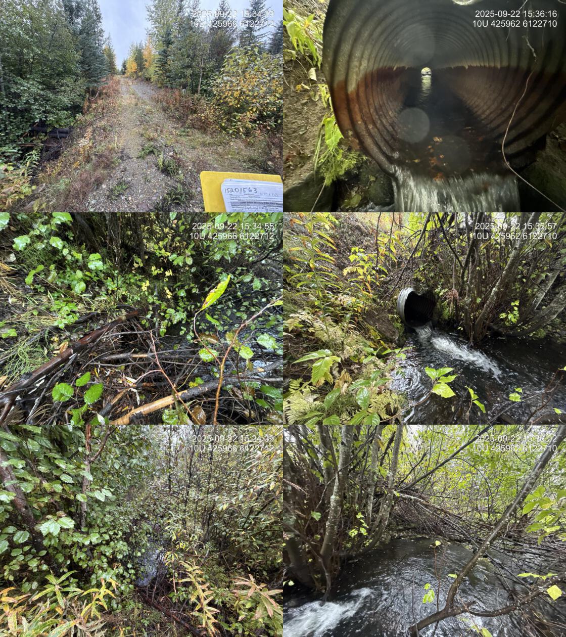
At the time of the 2025 assessment, PSCIS crossing 203597 on Thut 15000 was un-embedded, non-backwatered and ranked as barrier to upstream fish passage according to the provincial protocol (MoE 2011) (Table 5.25).
The water temperature was 6.5\(^\circ\)C, pH was 7.5 and conductivity was 188 uS/cm.
| Location and Stream Data |
|
Crossing Characteristics | – |
|---|---|---|---|
| Date | 2025-09-22 | Crossing Sub Type | Round Culvert |
| PSCIS ID | 203597 | Diameter (m) | 0.8 |
| External ID | 15201563 | Length (m) | 19 |
| Crew | AI | Embedded | No |
| UTM Zone | 10 | Depth Embedded (m) | – |
| Easting | 425959 | Resemble Channel | – |
| Northing | 6122703 | Backwatered | No |
| Stream | Tributary To Nation River | Percent Backwatered | – |
| Road | Thut 15000 | Fill Depth (m) | 1.5 |
| Road Tenure | Sekani R07214 8 | Outlet Drop (m) | 0.25 |
| Channel Width (m) | 2.5 | Outlet Pool Depth (m) | 0.5 |
| Stream Slope (%) | 2.5 | Inlet Drop | Yes |
| Beaver Activity | No | Slope (%) | 1 |
| Habitat Value | High | Valley Fill | Deep Fill |
| Final score | 29 | Barrier Result | Barrier |
| Fix type | Replace with New Open Bottom Structure | Fix Span / Diameter | 15 |
| Comments: High-quality stream with abundant gravels and cover, directly connected to the Nation River. Bull trout noted near the confluence. eDNA samples collected upstream and downstream of the crossing. This crossing is located on a road identified by BCTS as a candidate for potential deactivation. | |||
| Photos: From top left clockwise: Road/Site Card, Barrel, Outlet, Downstream, Upstream, Inlet. | |||
|
Stream Characteristics Downstream of Crossing 203597
The stream was surveyed downstream from crossing 203597 for 400m (Figure 5.26). The stream had good flow, likely elevated due to significant precipitation the previous night. Abundant gravels were present throughout, and cover was provided by multiple sources including woody debris and undercut banks. No barriers were observed. The average channel width was 2.8m, the average wetted width was 2.6m, and the average gradient was 3%.Total cover amount was rated as abundant with undercut banks dominant. Cover was also present as small woody debris, large woody debris, boulders, deep pools, and overhanging vegetation.The dominant substrate was cobbles with gravels sub-dominant.
Stream Characteristics Upstream of Crossing 203597
The stream was surveyed upstream from crossing 203597 for 350m up to the beginning of the wetlands (Figure 5.27). The habitat was rated as NA value. Total cover amount was rated as moderate with small woody debris dominant. Cover was also present as large woody debris, undercut banks, and overhanging vegetation.The average channel width was 2.5m, the average wetted width was 2.4m, and the average gradient was 3%.The dominant substrate was fines with cobbles sub-dominant. The stream had good flow, although recent rainfall may have influenced discharge. Pockets of gravels were present within the area surveyed. Wetlands adjacent to the channel appeared shallow, suggesting they may freeze to the bottom during winter.
##this is useful to get some comments for the report
form_edna |>filter(site == my_site & location == 'ds') |>pull(comments_field)
form_edna |>filter(site == my_site & location == 'ds') |>pull(comments_lab)


form_edna |>filter(site == my_site & location == 'us') |>pull(comments_field)
form_edna |>filter(site == my_site & location == 'us') |>pull(comments_lab)
Environmental DNA
eDNA samples were collected both upstream and downstream of crossing 203597 on Thut 15000, with sampling techniques summarized in Table 5.26. Samples were submitted to UNBC for ddPCR analysis against Bull Trout, Arctic Grayling, Rainbow Trout, and Kokanee assays. Per-position results from real environmental samples are summarized in Table 5.27. Detections are based on the standard ddPCR call threshold of ≥4 positive droplets; format is CODE(max_droplets), with * flagging samples UNBC reran.
Field blank at this crossing. Sample 203597_ds_ed1a (UNBC ID M41365) was a field blank — distilled water filtered at the field site to test for protocol contamination, not site eDNA. UNBC’s analysis returned a low-level Rainbow Trout signal at this blank (4 positive droplets, ≈0.27 copies/μL). Per ddPCR convention this represents protocol-side contamination during collection or processing, not species presence at this location. The blank is presented in the Controls layer of the interactive map (off by default) and in the field-blanks table within Appendix - Environmental DNA Results.
Site-level detail across all sampled crossings is in Appendix - Environmental DNA Results. as well as within the interactive Peace eDNA map.
my_caption <- paste0("Summary of eDNA samples collected at site ", my_site, ".")

tab_edna |>
  dplyr::filter(site == my_site) |>
  dplyr::select(-site) |>
    dplyr::arrange(Site) |>
fpr_kable(caption_text = my_caption, scroll = FALSE)| Site | Stream | Habitat Type | Sample Method | Filter Type | Filter Size (um) | Volume filtered (L) | Site Description |
|---|---|---|---|---|---|---|---|
| 203597_ds_ed1b | Tributary To Nation River | riffle | grab | mce | 1 | 1.7 | Sample collected 350 - 400m downstream of culvert. Right bank. Accessed via historic road which is now wildlife trail. |
| 203597_us_ed1 | Tributary To Nation River | riffle | inatream | mce | 1 | 2.0 | Sample collected 5m upstream of the culvert on the left bank |
edna_results_203597 |>
  fpr::fpr_kable(
    caption_text = paste0("eDNA detection results at crossing ", my_site, " (real environmental samples)."),
    scroll = FALSE
)| Site ID | UNBC ID | Detected | Sub-threshold | Not detected |
|---|---|---|---|---|
| 203597_ds_ed1b | M41366 | RAIN(173)* | BULT(3)* | GRAY(0), SOCK(0) |
| 203597_us_ed1 | M41367 | RAIN(213)* | — | BULT(0), GRAY(0), SOCK(0)* |
Structure Remediation and Cost Estimate
Since the time of field assessements this crossing was deactivated by BC Timber Sales.
Conclusion
The habitat upstream of PSCIS crossing 203597 on Thut 15000 was documented as medium value for salmonid spawning and rearing, and the crossing was rated as a high for deactivation.
Since the assessment season, the FWCP 2026 proposal for riparian enhancements at this site was accepted. Planned work consists of soil decompaction along the deactivated road prism, riparian planting with native species, and placement of coarse woody debris to advance recovery of the channel margin. Environmental DNA sampling confirmed rainbow trout both upstream and downstream of the crossing; an under-threshold bull trout detection is suspected to reflect real presence given the suitable size of the stream and its proximity to the Nation River, where bull trout detections are recorded in provincial records near the subject stream’s confluence with the Nation.
tab_hab_summary |>
  dplyr::filter(Site %in% c(my_site)) |>
  fpr::fpr_kable(caption_text = paste0("Summary of habitat details for PSCIS crossing ", my_site, "."),
scroll = F) | Site | Location | Length Surveyed (m) | Average Channel Width (m) | Average Wetted Width (m) | Average Pool Depth (m) | Average Gradient (%) | Total Cover | Habitat Value |
|---|---|---|---|---|---|---|---|---|
| 203597 | Downstream | 400 | 2.8 | 2.6 | 0.3 | 3 | abundant | high |
| 203597 | Upstream | 350 | 2.5 | 2.4 | 0.3 | 3 | moderate | – |
my_photo1 = fpr::fpr_photo_pull_by_str(str_to_pull = 'ds_typical_1_')

my_caption1 = paste0('Typical habitat downstream of PSCIS crossing ', my_site, '.')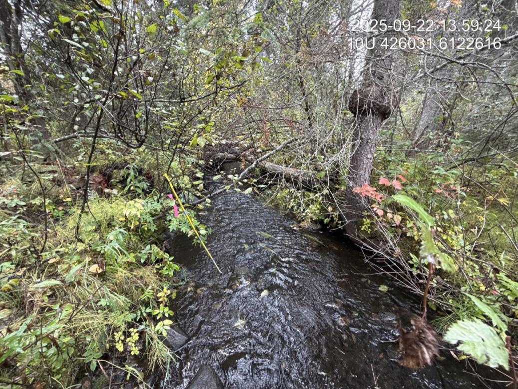
Figure 5.26: Typical habitat downstream of PSCIS crossing 203597.
my_photo2 = fpr::fpr_photo_pull_by_str(str_to_pull = 'us_typical_2_')

my_caption2 = paste0('Wetland habitat located 350m upstream of PSCIS crossing ', my_site, '.')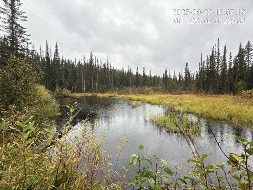
Figure 5.27: Wetland habitat located 350m upstream of PSCIS crossing 203597.
my_caption <- paste0('Left: ', my_caption1, ' Right: ', my_caption2)

knitr::include_graphics(my_photo1)
knitr::include_graphics("fig/pixel.png")
knitr::include_graphics(my_photo2)