Appendix - Phase 1 Fish Passage Assessment Data and Photos
| Location and Stream Data |
|
Crossing Characteristics | – |
|---|---|---|---|
| Date | 2020-08-26 | Crossing Sub Type | Round Culvert |
| PSCIS ID | 197640 | Diameter (m) | 1.5 |
| External ID | 1800092 | Length (m) | 12 |
| Crew | AI, KP | Embedded | No |
| UTM Zone | 9 | Depth Embedded (m) | – |
| Easting | 654312 | Resemble Channel | No |
| Northing | 6012383 | Backwatered | No |
| Stream | Tributary to Buck Creek | Percent Backwatered | – |
| Road | Buck Flats FSR | Fill Depth (m) | 1 |
| Road Tenure | MoTi local | Outlet Drop (m) | 0.4 |
| Channel Width (m) | 5.1 | Outlet Pool Depth (m) | 1.2 |
| Stream Slope (%) | 3 | Inlet Drop | No |
| Beaver Activity | No | Slope (%) | 1.5 |
| Habitat Value | High | Valley Fill | Deep Fill |
| Final score | 31 | Barrier Result | Barrier |
| Fix type | Replace with New Open Bottom Structure | Fix Span / Diameter | – |
Photos: PSCIS ID 197640. From top left clockwise: Road/Site Card, Barrel, Outlet, Downstream, Upstream, Inlet.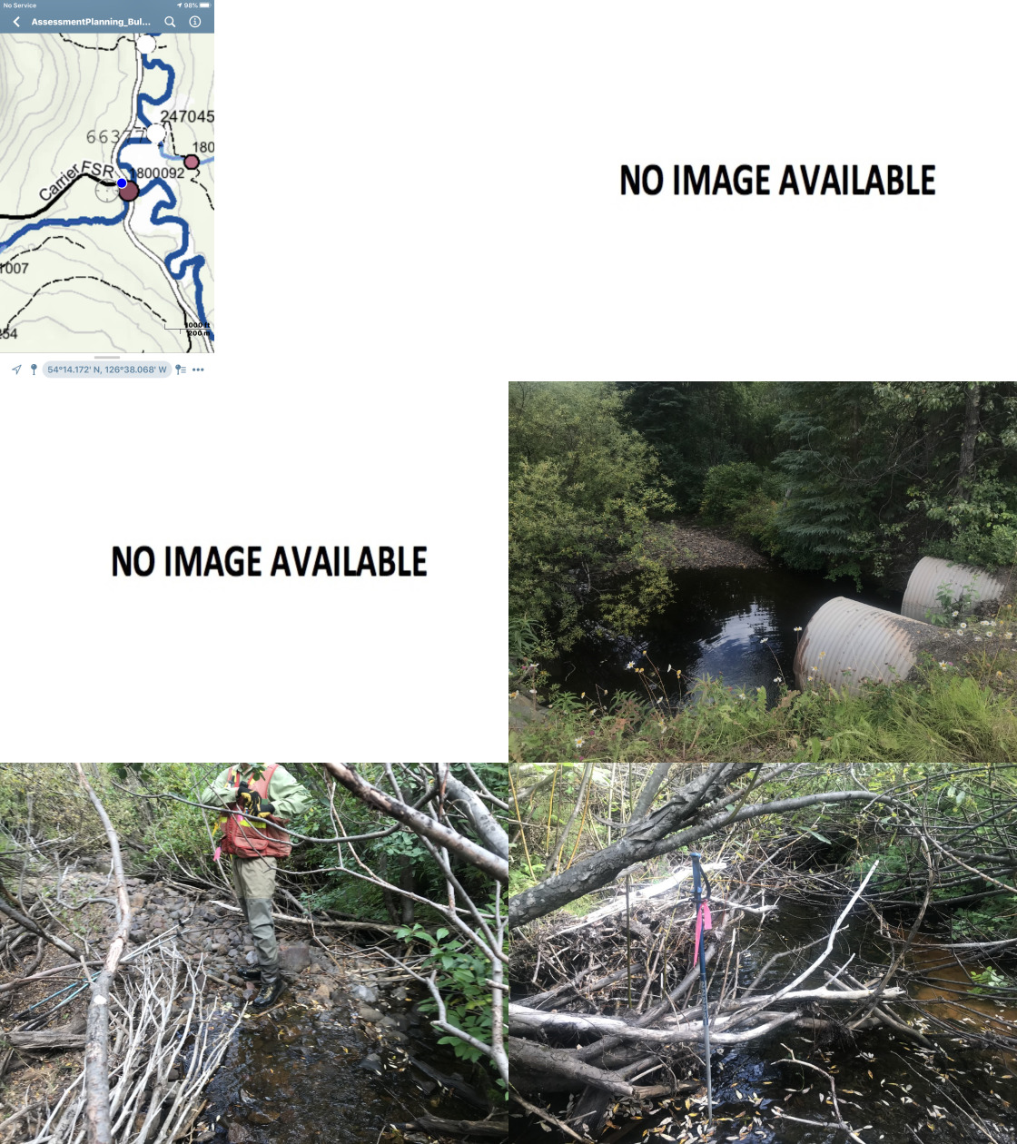
|
|||
| Comments: Large tributary on section of tributary connected to salmon bearing Buck Creek. Fish rising in outlet pool (estimated 130mm). Some cattle access points downstream. Habitat confirmation conducted at this site. |
| Location and Stream Data |
|
Crossing Characteristics | – |
|---|---|---|---|
| Date | 2020-08-26 | Crossing Sub Type | Pipe Arch |
| PSCIS ID | 197641 | Diameter (m) | 4.5 |
| External ID | 1805182 | Length (m) | 18 |
| Crew | KP, AI | Embedded | – |
| UTM Zone | 9 | Depth Embedded (m) | – |
| Easting | 675368.2 | Resemble Channel | – |
| Northing | 6004484 | Backwatered | – |
| Stream | Tributary to Buck Creek | Percent Backwatered | – |
| Road | Parrot FSR | Fill Depth (m) | – |
| Road Tenure | FLNR Nadina 9772 | Outlet Drop (m) | – |
| Channel Width (m) | – | Outlet Pool Depth (m) | – |
| Stream Slope (%) | – | Inlet Drop | – |
| Beaver Activity | No | Slope (%) | – |
| Habitat Value | – | Valley Fill | – |
| Final score | 3 | Barrier Result | Passable |
| Fix type | – | Fix Span / Diameter | – |
Photos: PSCIS ID 197641. From top left clockwise: Road/Site Card, Barrel, Outlet, Downstream, Upstream, Inlet.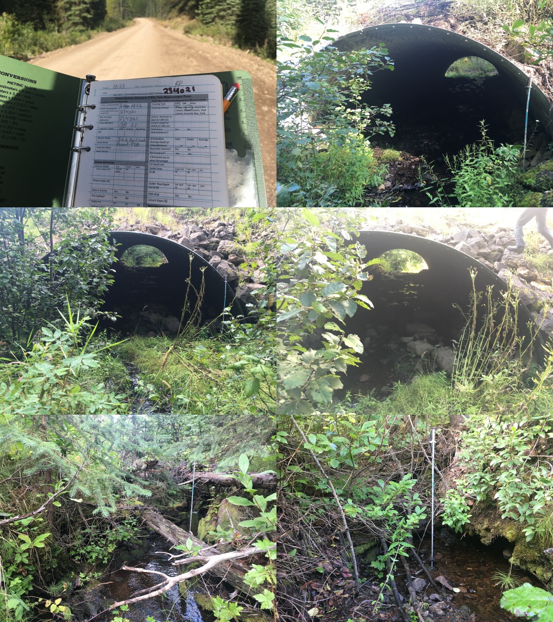
|
|||
| Comments: Newly constructed passable structure. |
| Location and Stream Data |
|
Crossing Characteristics | – |
|---|---|---|---|
| Date | 2020-08-26 | Crossing Sub Type | Ford |
| PSCIS ID | 197642 | Diameter (m) | – |
| External ID | 1805455 | Length (m) | – |
| Crew | AI, KP | Embedded | – |
| UTM Zone | 9 | Depth Embedded (m) | – |
| Easting | 675328.8 | Resemble Channel | – |
| Northing | 6004247 | Backwatered | – |
| Stream | Tributary to Buck Creek | Percent Backwatered | – |
| Road | Spur off Parrot FSR | Fill Depth (m) | – |
| Road Tenure | – | Outlet Drop (m) | – |
| Channel Width (m) | – | Outlet Pool Depth (m) | – |
| Stream Slope (%) | – | Inlet Drop | – |
| Beaver Activity | No | Slope (%) | – |
| Habitat Value | – | Valley Fill | – |
| Final score | 0 | Barrier Result | Unknown |
| Fix type | – | Fix Span / Diameter | – |
Photos: PSCIS ID 197642. From top left clockwise: Road/Site Card, Barrel, Outlet, Downstream, Upstream, Inlet.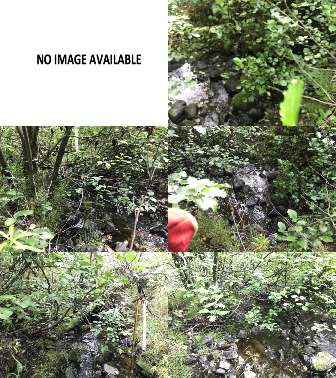
|
|||
| Comments: Ford. No issues. |
| Location and Stream Data |
|
Crossing Characteristics | – |
|---|---|---|---|
| Date | 2020-08-26 | Crossing Sub Type | Bridge |
| PSCIS ID | 197643 | Diameter (m) | 4.7 |
| External ID | 1805183 | Length (m) | 16 |
| Crew | KP, AI | Embedded | – |
| UTM Zone | 9 | Depth Embedded (m) | – |
| Easting | 677098.7 | Resemble Channel | – |
| Northing | 6003221 | Backwatered | – |
| Stream | Buck Creek | Percent Backwatered | – |
| Road | Goosley North Rd | Fill Depth (m) | – |
| Road Tenure | FLNR Nadina 9772 | Outlet Drop (m) | – |
| Channel Width (m) | – | Outlet Pool Depth (m) | – |
| Stream Slope (%) | – | Inlet Drop | – |
| Beaver Activity | No | Slope (%) | – |
| Habitat Value | – | Valley Fill | – |
| Final score | 3 | Barrier Result | Passable |
| Fix type | – | Fix Span / Diameter | – |
Photos: PSCIS ID 197643. From top left clockwise: Road/Site Card, Barrel, Outlet, Downstream, Upstream, Inlet.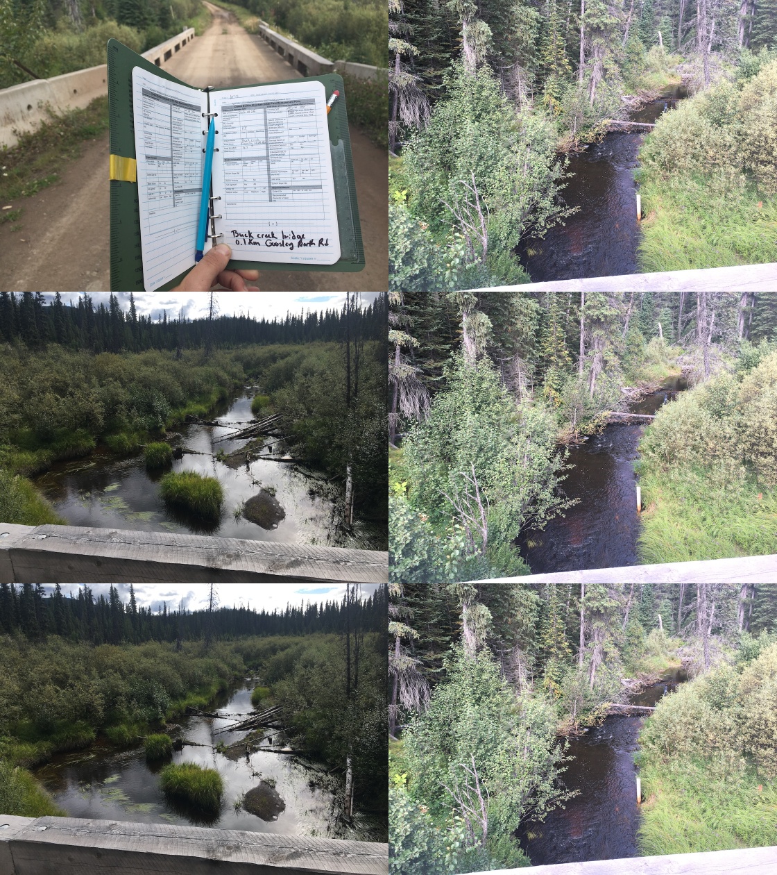
|
|||
| Comments: Bridge. |
| Location and Stream Data |
|
Crossing Characteristics | – |
|---|---|---|---|
| Date | 2020-08-26 | Crossing Sub Type | Ford |
| PSCIS ID | 197644 | Diameter (m) | – |
| External ID | 1803661 | Length (m) | – |
| Crew | AI, KP | Embedded | – |
| UTM Zone | 9 | Depth Embedded (m) | – |
| Easting | 677101.1 | Resemble Channel | – |
| Northing | 6003177 | Backwatered | – |
| Stream | Tributary to Buck Creek | Percent Backwatered | – |
| Road | Spur off Parrot FSR | Fill Depth (m) | – |
| Road Tenure | Canfor R10460 | Outlet Drop (m) | – |
| Channel Width (m) | – | Outlet Pool Depth (m) | – |
| Stream Slope (%) | – | Inlet Drop | – |
| Beaver Activity | No | Slope (%) | – |
| Habitat Value | – | Valley Fill | – |
| Final score | 0 | Barrier Result | Unknown |
| Fix type | – | Fix Span / Diameter | – |
Photos: PSCIS ID 197644. From top left clockwise: Road/Site Card, Barrel, Outlet, Downstream, Upstream, Inlet.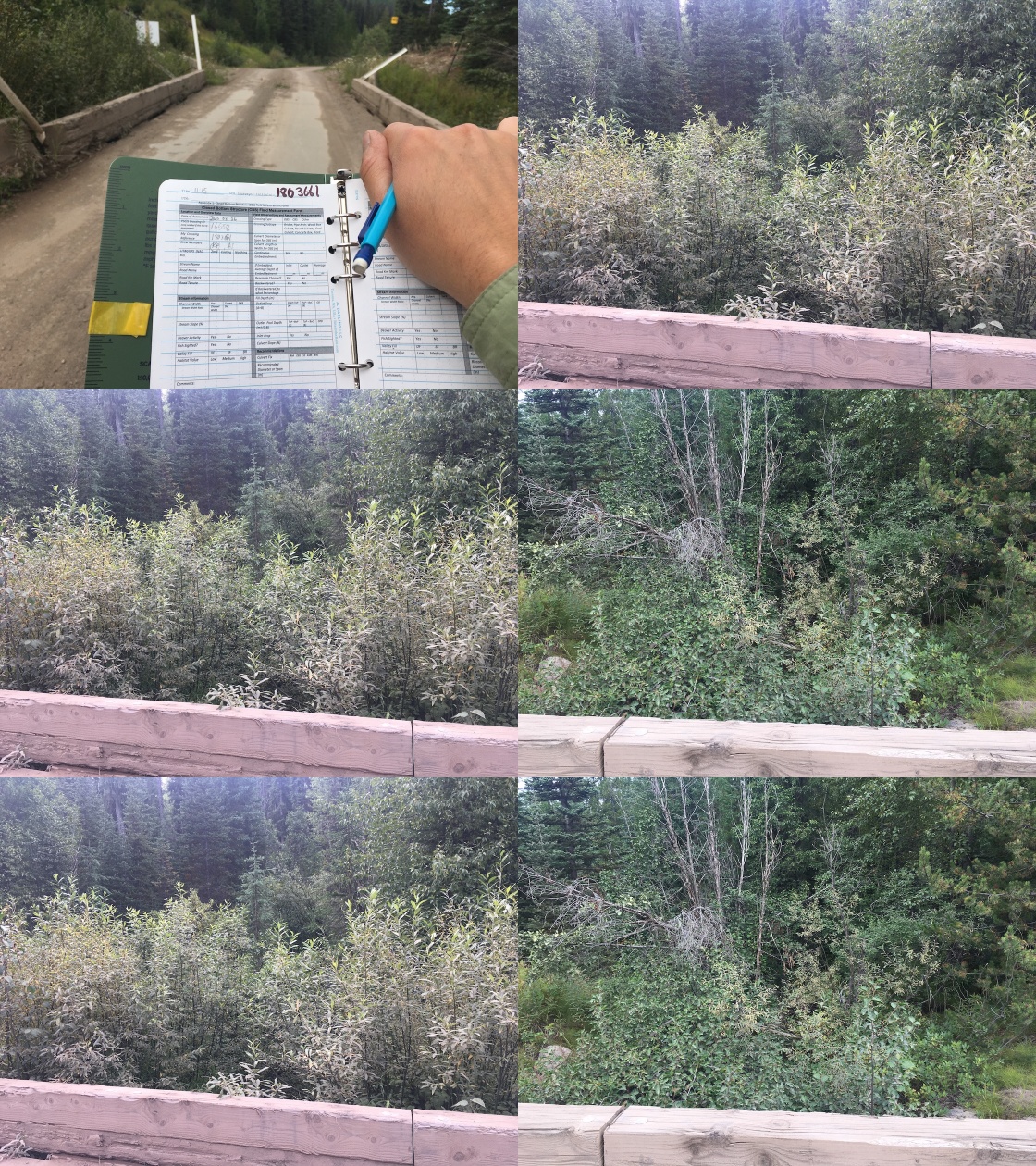
|
|||
| Comments: Ford. No issues. |
| Location and Stream Data |
|
Crossing Characteristics | – |
|---|---|---|---|
| Date | 2020-08-26 | Crossing Sub Type | Pipe Arch |
| PSCIS ID | 197645 | Diameter (m) | 7 |
| External ID | 1800472 | Length (m) | 21 |
| Crew | KP, AI | Embedded | – |
| UTM Zone | 9 | Depth Embedded (m) | – |
| Easting | 678411 | Resemble Channel | – |
| Northing | 6002821 | Backwatered | – |
| Stream | Tributary to Buck Creek | Percent Backwatered | – |
| Road | Parrot FSR | Fill Depth (m) | – |
| Road Tenure | MoTi unclassified | Outlet Drop (m) | – |
| Channel Width (m) | – | Outlet Pool Depth (m) | – |
| Stream Slope (%) | – | Inlet Drop | – |
| Beaver Activity | No | Slope (%) | – |
| Habitat Value | – | Valley Fill | – |
| Final score | 3 | Barrier Result | Passable |
| Fix type | – | Fix Span / Diameter | – |
Photos: PSCIS ID 197645. From top left clockwise: Road/Site Card, Barrel, Outlet, Downstream, Upstream, Inlet.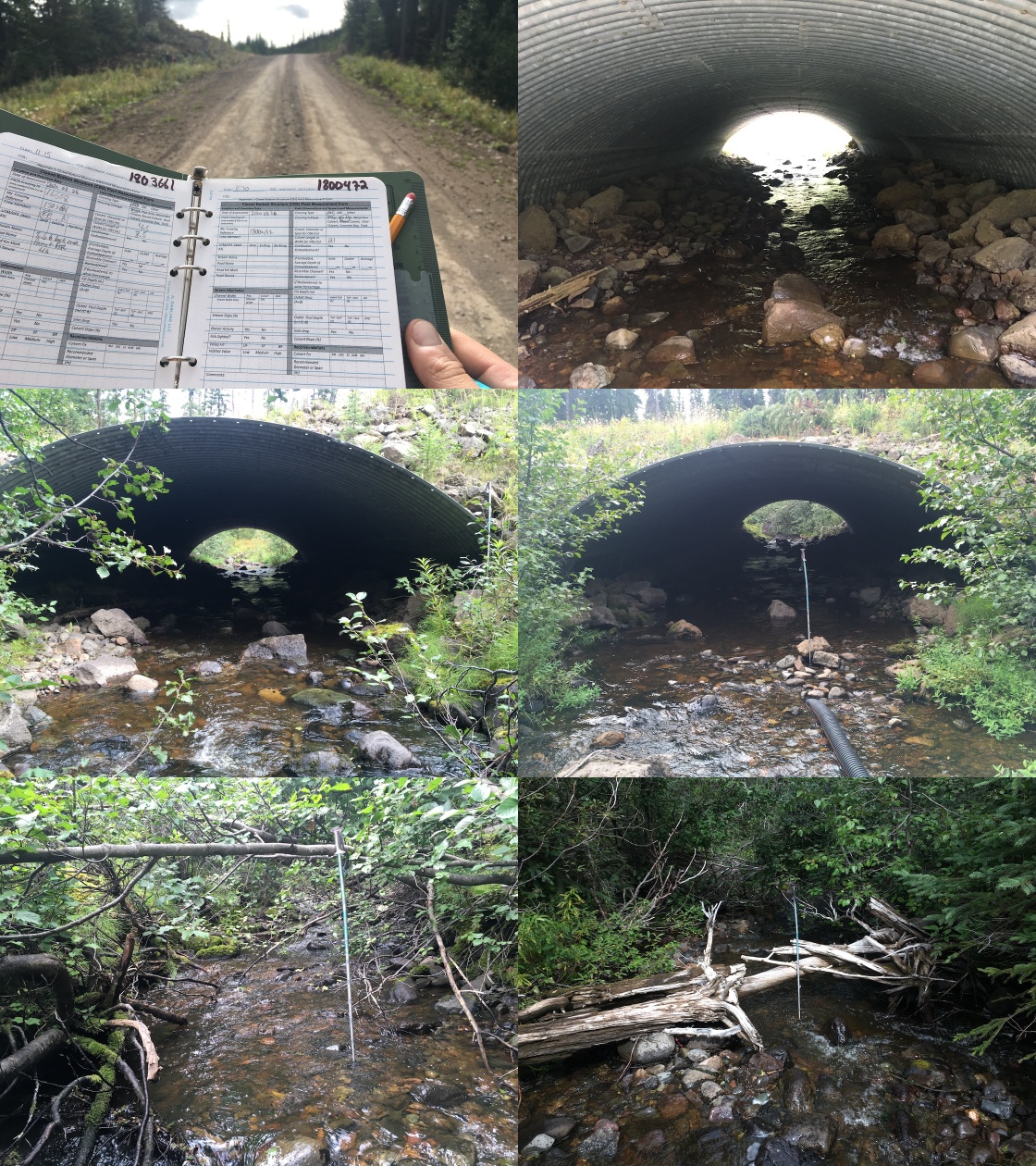
|
|||
| Comments: Newly constructed passable structure. |
| Location and Stream Data |
|
Crossing Characteristics | – |
|---|---|---|---|
| Date | 2020-08-26 | Crossing Sub Type | Round Culvert |
| PSCIS ID | 197646 | Diameter (m) | 1 |
| External ID | 1802520 | Length (m) | 10 |
| Crew | AI, KP | Embedded | No |
| UTM Zone | 9 | Depth Embedded (m) | – |
| Easting | 672023 | Resemble Channel | No |
| Northing | 6005200 | Backwatered | No |
| Stream | Tributary to Buck Creek | Percent Backwatered | – |
| Road | Spur off Parrot FSR | Fill Depth (m) | 1.2 |
| Road Tenure | R216960010 | Outlet Drop (m) | 0 |
| Channel Width (m) | 1.4 | Outlet Pool Depth (m) | 0.42 |
| Stream Slope (%) | 5 | Inlet Drop | No |
| Beaver Activity | Yes | Slope (%) | 1 |
| Habitat Value | Medium | Valley Fill | Deep Fill |
| Final score | 21 | Barrier Result | Barrier |
| Fix type | Replace Structure with Streambed Simulation CBS | Fix Span / Diameter | 3 |
Photos: PSCIS ID 197646. From top left clockwise: Road/Site Card, Barrel, Outlet, Downstream, Upstream, Inlet.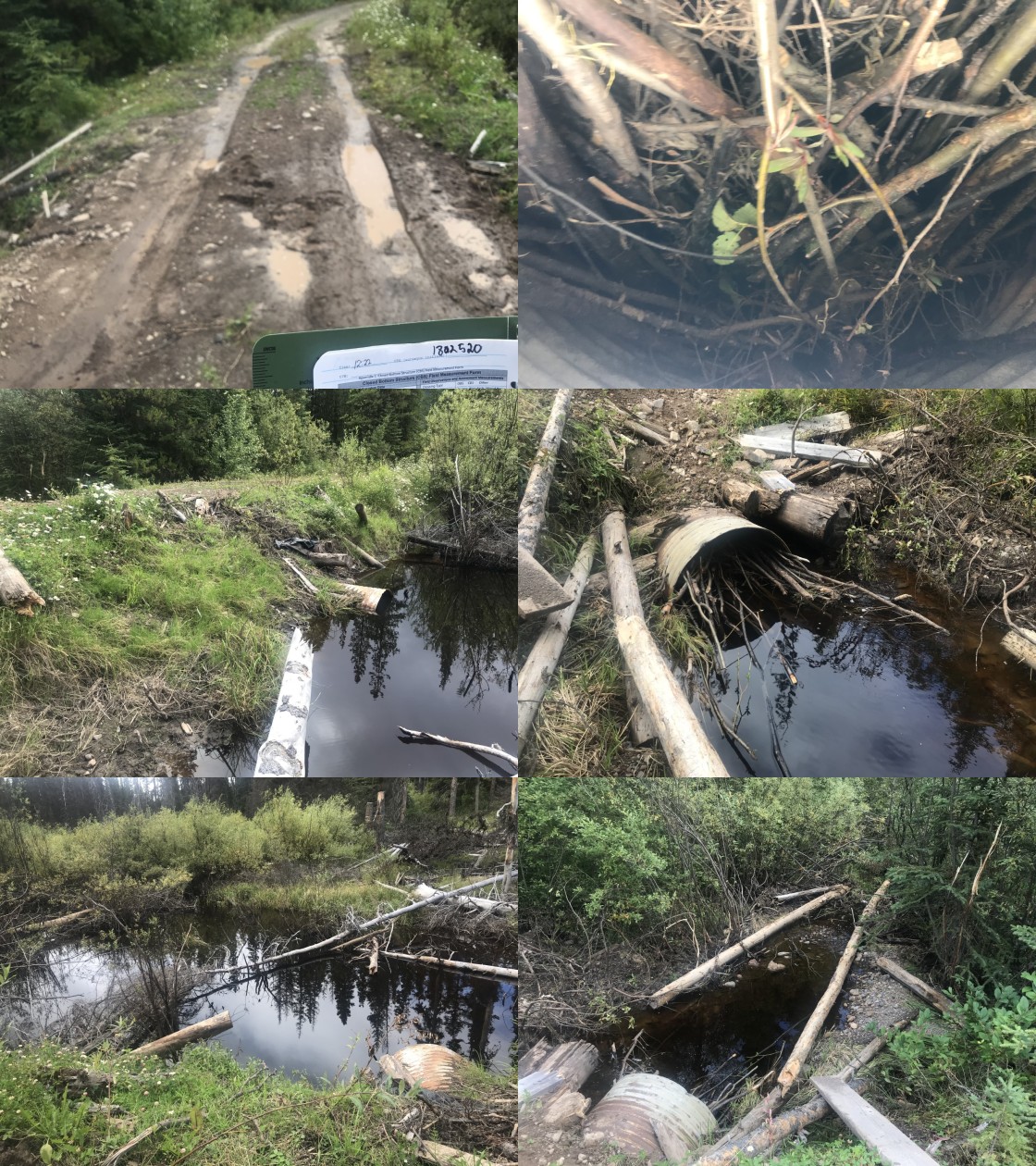
|
|||
| Comments: Stream drains Sam Lake. Old log bridge type stucture tha is collaping with round culvert inserted. Pipe contains beaver debris. Wetland habitat upstream. |
| Location and Stream Data |
|
Crossing Characteristics | – |
|---|---|---|---|
| Date | 2020-08-26 | Crossing Sub Type | Round Culvert |
| PSCIS ID | 197647 | Diameter (m) | 1 |
| External ID | 1804986 | Length (m) | 16 |
| Crew | KP, AI | Embedded | No |
| UTM Zone | 9 | Depth Embedded (m) | – |
| Easting | 651263.5 | Resemble Channel | No |
| Northing | 6012508 | Backwatered | No |
| Stream | Tributary to Buck Creek | Percent Backwatered | – |
| Road | Carrier FSR | Fill Depth (m) | 1.8 |
| Road Tenure | FLNR Nadina 9772 | Outlet Drop (m) | 0.3 |
| Channel Width (m) | 1.5 | Outlet Pool Depth (m) | 0 |
| Stream Slope (%) | 2 | Inlet Drop | No |
| Beaver Activity | No | Slope (%) | 1.5 |
| Habitat Value | Low | Valley Fill | Deep Fill |
| Final score | 34 | Barrier Result | Barrier |
| Fix type | Replace Structure with Streambed Simulation CBS | Fix Span / Diameter | 3 |
Photos: PSCIS ID 197647. From top left clockwise: Road/Site Card, Barrel, Outlet, Downstream, Upstream, Inlet.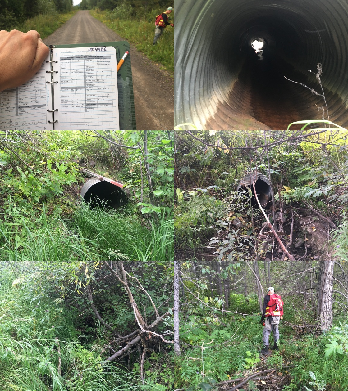
|
|||
| Comments: Suspect no fish. Multiple fish survey sites located downstream. Dry at time of survey. |
| Location and Stream Data |
|
Crossing Characteristics | – |
|---|---|---|---|
| Date | 2020-08-26 | Crossing Sub Type | Bridge |
| PSCIS ID | 197648 | Diameter (m) | 5 |
| External ID | 1804153 | Length (m) | 9 |
| Crew | KP, AI | Embedded | – |
| UTM Zone | 9 | Depth Embedded (m) | – |
| Easting | 653554 | Resemble Channel | – |
| Northing | 6015856 | Backwatered | – |
| Stream | Tributary to Buck Creek | Percent Backwatered | – |
| Road | Balsam FSR | Fill Depth (m) | – |
| Road Tenure | FLNR Nadina 9486 | Outlet Drop (m) | – |
| Channel Width (m) | – | Outlet Pool Depth (m) | – |
| Stream Slope (%) | – | Inlet Drop | – |
| Beaver Activity | No | Slope (%) | – |
| Habitat Value | – | Valley Fill | – |
| Final score | 0 | Barrier Result | Passable |
| Fix type | – | Fix Span / Diameter | – |
Photos: PSCIS ID 197648. From top left clockwise: Road/Site Card, Barrel, Outlet, Downstream, Upstream, Inlet.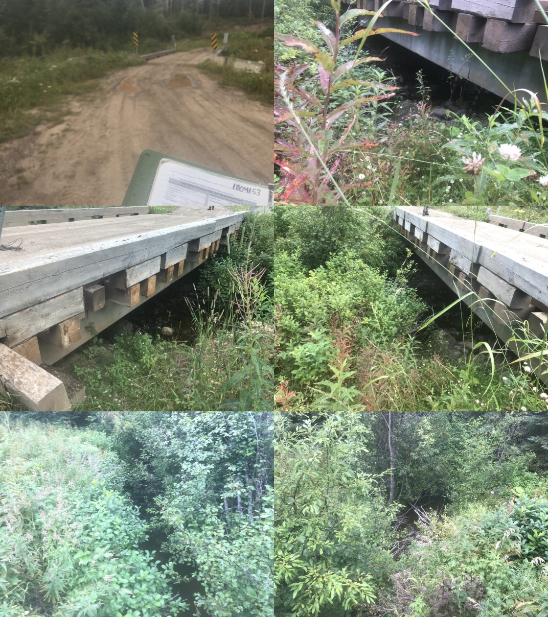
|
|||
| Comments: Bridge. No issues. |
| Location and Stream Data |
|
Crossing Characteristics | – |
|---|---|---|---|
| Date | 2020-08-26 | Crossing Sub Type | Bridge |
| PSCIS ID | 197649 | Diameter (m) | 5.5 |
| External ID | 1804151 | Length (m) | 12 |
| Crew | KP, AI | Embedded | – |
| UTM Zone | 9 | Depth Embedded (m) | – |
| Easting | 652876.1 | Resemble Channel | – |
| Northing | 6017367 | Backwatered | – |
| Stream | Tributary to Buck Creek | Percent Backwatered | – |
| Road | Balsam FSR | Fill Depth (m) | – |
| Road Tenure | FLNR Nadina 9486 | Outlet Drop (m) | – |
| Channel Width (m) | – | Outlet Pool Depth (m) | – |
| Stream Slope (%) | – | Inlet Drop | – |
| Beaver Activity | No | Slope (%) | – |
| Habitat Value | – | Valley Fill | – |
| Final score | 0 | Barrier Result | Passable |
| Fix type | – | Fix Span / Diameter | – |
Photos: PSCIS ID 197649. From top left clockwise: Road/Site Card, Barrel, Outlet, Downstream, Upstream, Inlet.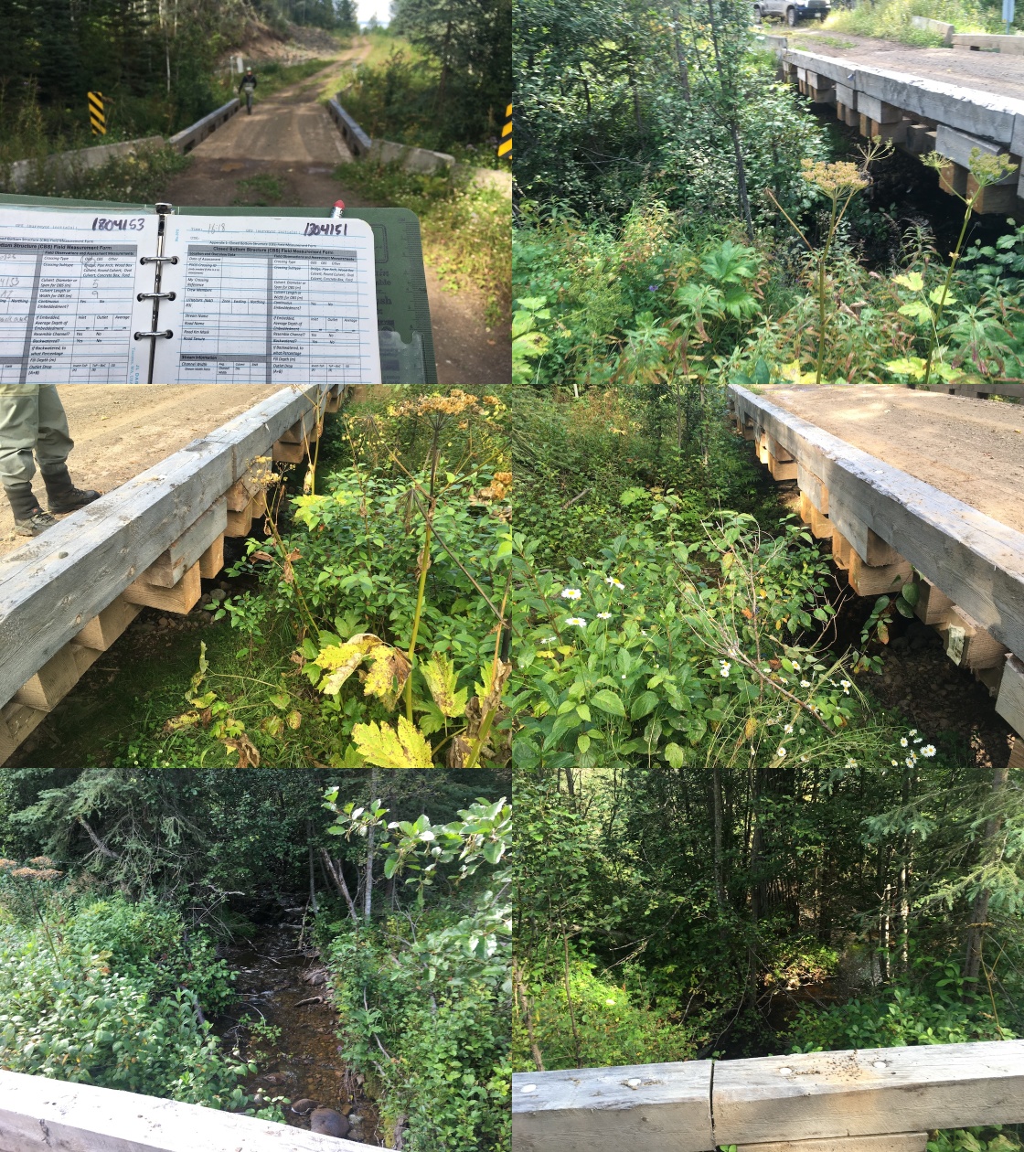
|
|||
| Comments: Bridge. No issues. |
| Location and Stream Data |
|
Crossing Characteristics | – |
|---|---|---|---|
| Date | 2020-08-26 | Crossing Sub Type | Bridge |
| PSCIS ID | 197650 | Diameter (m) | 4.8 |
| External ID | 1804851 | Length (m) | 13 |
| Crew | KP, AI | Embedded | – |
| UTM Zone | 9 | Depth Embedded (m) | – |
| Easting | 654032.4 | Resemble Channel | – |
| Northing | 6020242 | Backwatered | – |
| Stream | Bob Creek | Percent Backwatered | – |
| Road | Bob Creek FSR | Fill Depth (m) | – |
| Road Tenure | FLNR Nadina 10157 | Outlet Drop (m) | – |
| Channel Width (m) | – | Outlet Pool Depth (m) | – |
| Stream Slope (%) | – | Inlet Drop | – |
| Beaver Activity | No | Slope (%) | – |
| Habitat Value | – | Valley Fill | – |
| Final score | 0 | Barrier Result | Passable |
| Fix type | – | Fix Span / Diameter | – |
Photos: PSCIS ID 197650. From top left clockwise: Road/Site Card, Barrel, Outlet, Downstream, Upstream, Inlet.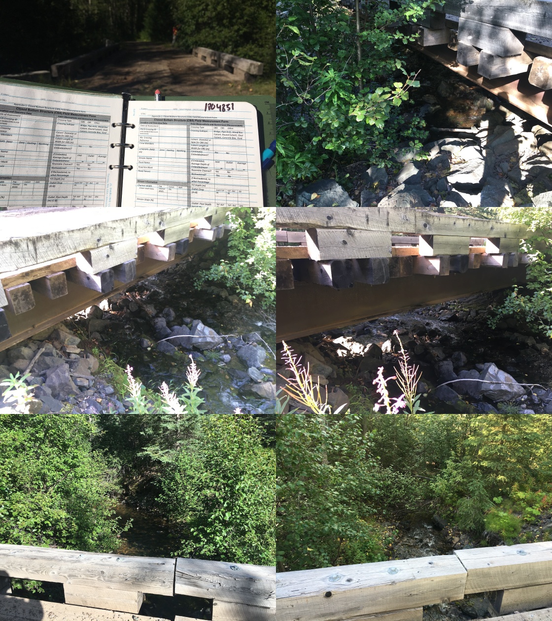
|
|||
| Comments: Bridge. No issues. |
| Location and Stream Data |
|
Crossing Characteristics | – |
|---|---|---|---|
| Date | 2020-08-26 | Crossing Sub Type | Ford |
| PSCIS ID | 197651 | Diameter (m) | – |
| External ID | 1800868 | Length (m) | – |
| Crew | AI, KP | Embedded | – |
| UTM Zone | 9 | Depth Embedded (m) | – |
| Easting | 672888 | Resemble Channel | – |
| Northing | 6005375 | Backwatered | – |
| Stream | Tributary to Goosly Lake | Percent Backwatered | – |
| Road | Spur off Parrot FSR | Fill Depth (m) | – |
| Road Tenure | MoTi unclassified | Outlet Drop (m) | – |
| Channel Width (m) | – | Outlet Pool Depth (m) | – |
| Stream Slope (%) | – | Inlet Drop | – |
| Beaver Activity | No | Slope (%) | – |
| Habitat Value | – | Valley Fill | – |
| Final score | 0 | Barrier Result | Unknown |
| Fix type | – | Fix Span / Diameter | – |
Photos: PSCIS ID 197651. From top left clockwise: Road/Site Card, Barrel, Outlet, Downstream, Upstream, Inlet.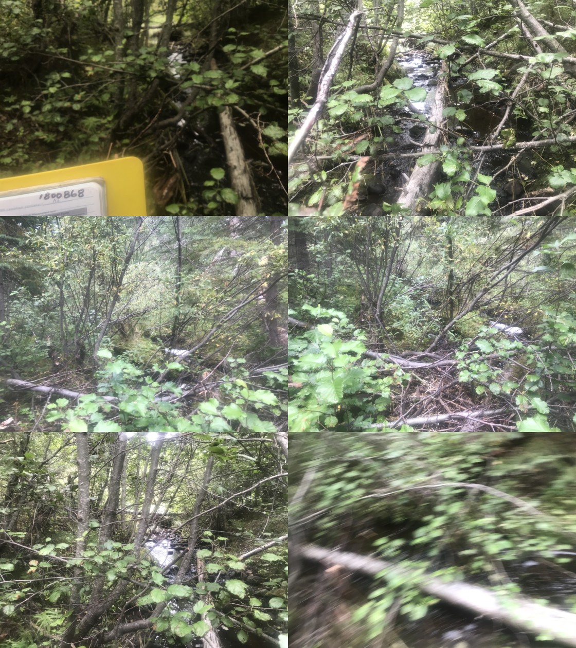
|
|||
| Comments: Ford. No issues. |
| Location and Stream Data |
|
Crossing Characteristics | – |
|---|---|---|---|
| Date | 2020-08-27 | Crossing Sub Type | Ford |
| PSCIS ID | 197652 | Diameter (m) | – |
| External ID | 1800077 | Length (m) | – |
| Crew | KP, AI | Embedded | – |
| UTM Zone | 9 | Depth Embedded (m) | – |
| Easting | 661696 | Resemble Channel | – |
| Northing | 6039603 | Backwatered | – |
| Stream | McInnes Creek | Percent Backwatered | – |
| Road | Unnamed | Fill Depth (m) | – |
| Road Tenure | MoTi unclassified | Outlet Drop (m) | – |
| Channel Width (m) | – | Outlet Pool Depth (m) | – |
| Stream Slope (%) | – | Inlet Drop | – |
| Beaver Activity | No | Slope (%) | – |
| Habitat Value | – | Valley Fill | – |
| Final score | 0 | Barrier Result | Unknown |
| Fix type | – | Fix Span / Diameter | – |
Photos: PSCIS ID 197652. From top left clockwise: Road/Site Card, Barrel, Outlet, Downstream, Upstream, Inlet.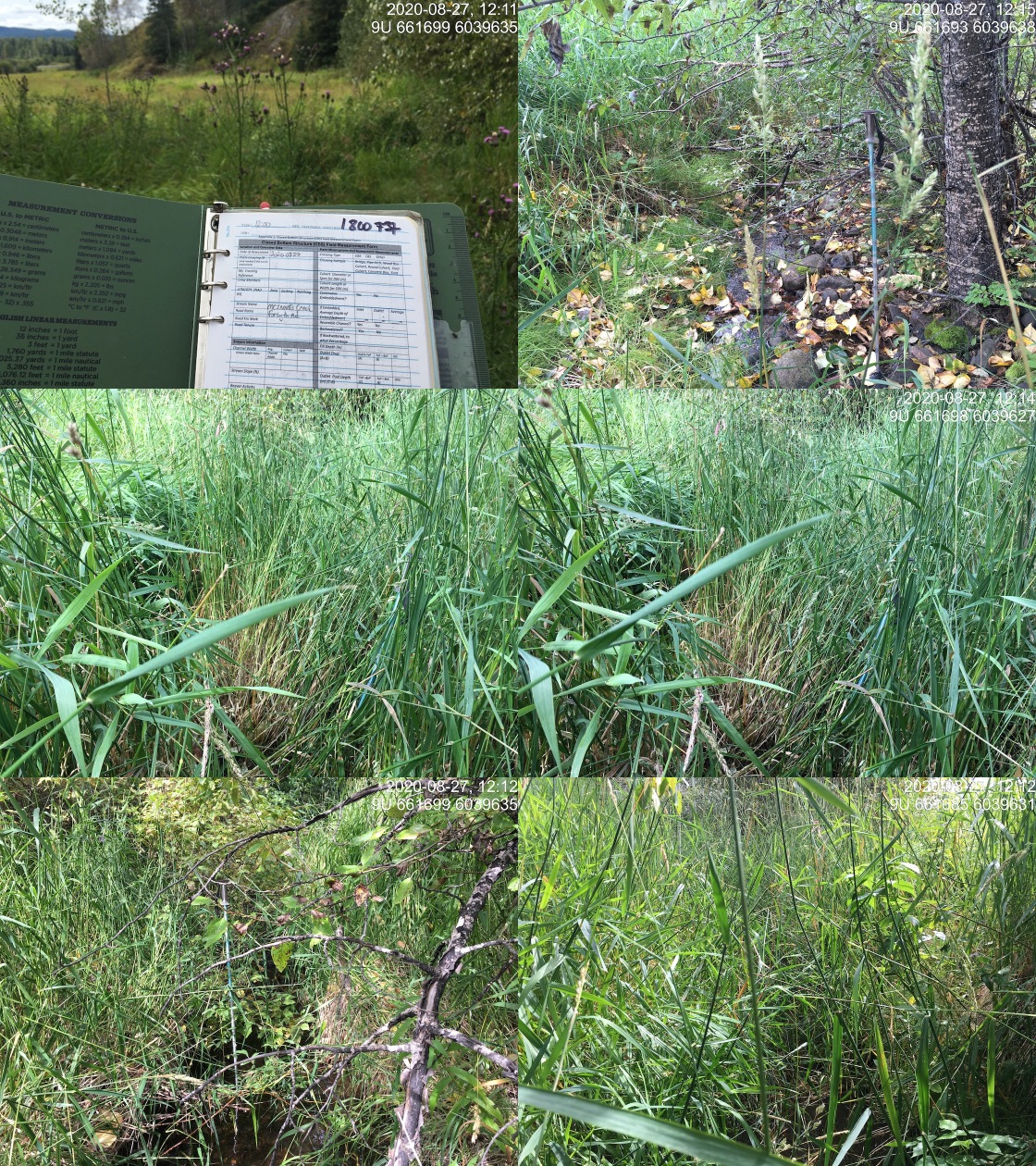
|
|||
| Comments: Ford. No issues. |
| Location and Stream Data |
|
Crossing Characteristics | – |
|---|---|---|---|
| Date | 2020-08-27 | Crossing Sub Type | Round Culvert |
| PSCIS ID | 197653 | Diameter (m) | 2 |
| External ID | 1800068 | Length (m) | 32 |
| Crew | KP, AI | Embedded | No |
| UTM Zone | 9 | Depth Embedded (m) | – |
| Easting | 665518.1 | Resemble Channel | No |
| Northing | 6044192 | Backwatered | No |
| Stream | Perow Creek | Percent Backwatered | – |
| Road | Perow Loop Rd | Fill Depth (m) | 1 |
| Road Tenure | MoTi local | Outlet Drop (m) | 0.33 |
| Channel Width (m) | 2.5 | Outlet Pool Depth (m) | 0.26 |
| Stream Slope (%) | 3 | Inlet Drop | No |
| Beaver Activity | Yes | Slope (%) | 2.5 |
| Habitat Value | Medium | Valley Fill | Deep Fill |
| Final score | 34 | Barrier Result | Barrier |
| Fix type | Replace with New Open Bottom Structure | Fix Span / Diameter | 10 |
Photos: PSCIS ID 197653. From top left clockwise: Road/Site Card, Barrel, Outlet, Downstream, Upstream, Inlet.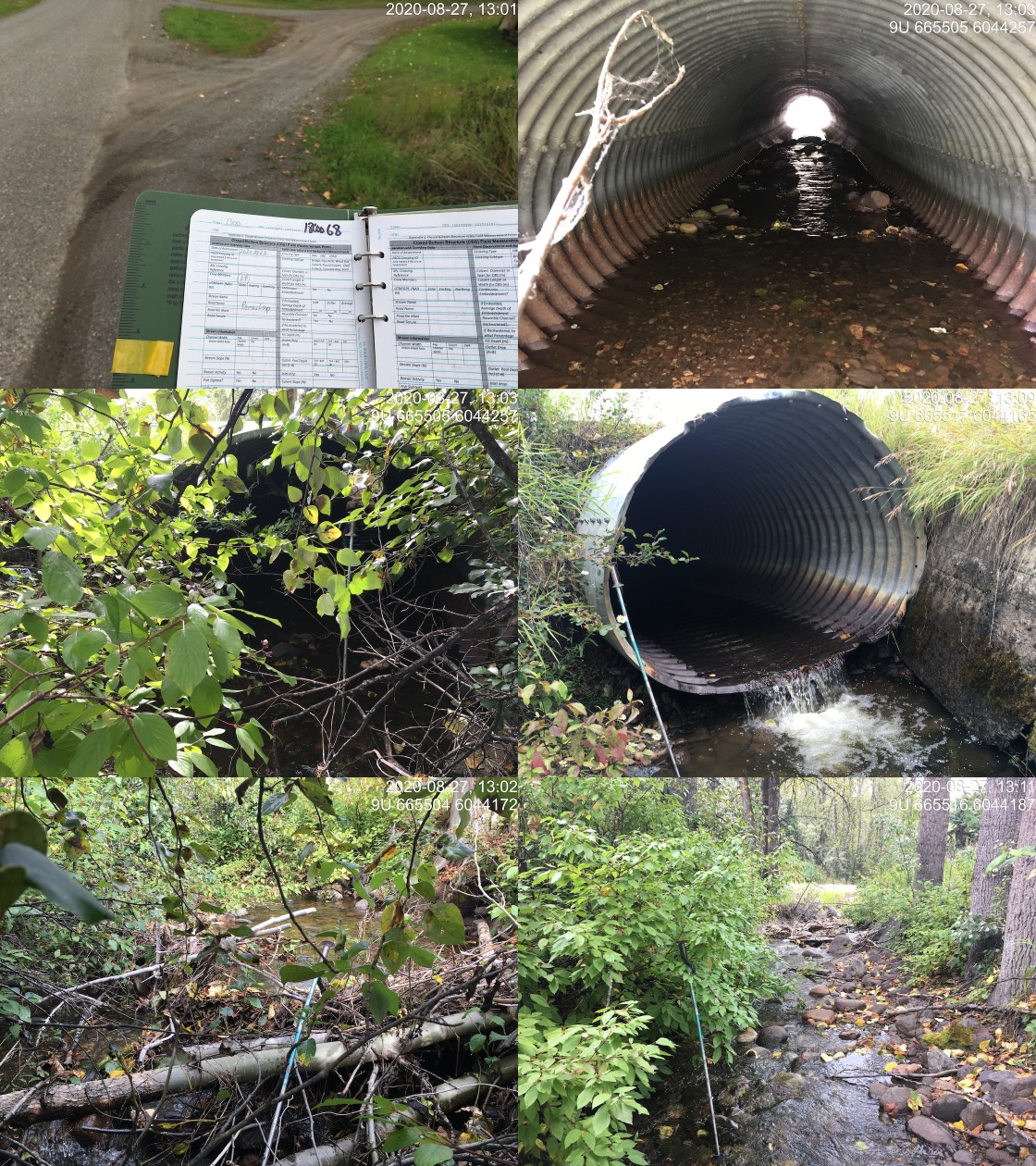
|
|||
| Comments: Private land. Channelized downstream with concrete slab riprap in place. Private driveway is crossing 1801071 upstream. |
| Location and Stream Data |
|
Crossing Characteristics | – |
|---|---|---|---|
| Date | 2020-08-26 | Crossing Sub Type | Round Culvert |
| PSCIS ID | 197654 | Diameter (m) | 1 |
| External ID | 1804152 | Length (m) | 20 |
| Crew | AI, KP | Embedded | No |
| UTM Zone | 9 | Depth Embedded (m) | – |
| Easting | 652746.5 | Resemble Channel | No |
| Northing | 6018036 | Backwatered | No |
| Stream | Tributary to Buck Creek | Percent Backwatered | – |
| Road | Balsam FSR | Fill Depth (m) | 2 |
| Road Tenure | FLNR Nadina 9486 | Outlet Drop (m) | 0.27 |
| Channel Width (m) | 1.5 | Outlet Pool Depth (m) | 0.12 |
| Stream Slope (%) | 5 | Inlet Drop | Yes |
| Beaver Activity | No | Slope (%) | 4 |
| Habitat Value | Medium | Valley Fill | Deep Fill |
| Final score | 34 | Barrier Result | Barrier |
| Fix type | Replace Structure with Streambed Simulation CBS | Fix Span / Diameter | 3 |
Photos: PSCIS ID 197654. From top left clockwise: Road/Site Card, Barrel, Outlet, Downstream, Upstream, Inlet.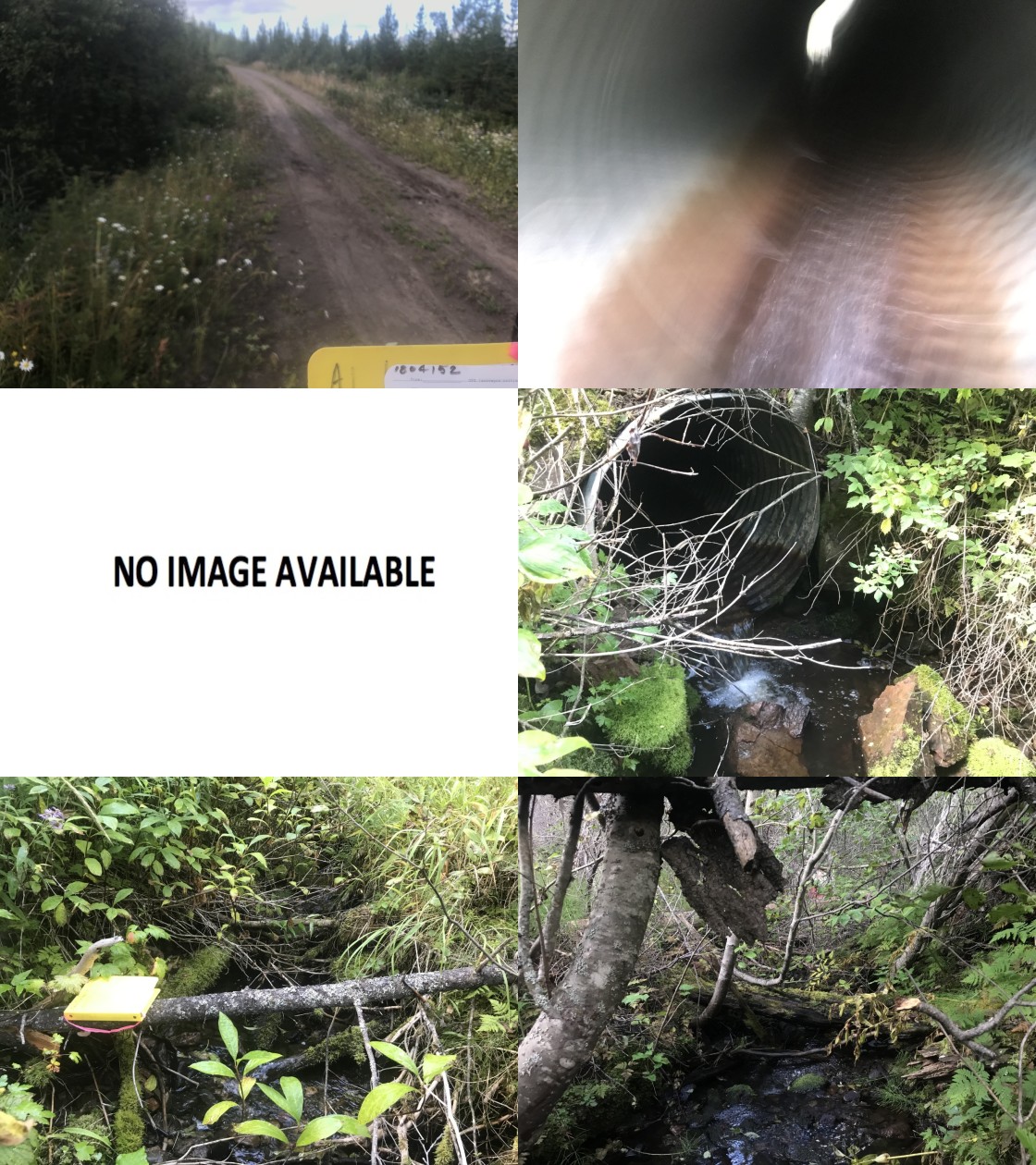
|
|||
| Comments: Good flow. Stream likley has inventory information. Should check with Canfor. |
| Location and Stream Data |
|
Crossing Characteristics | – |
|---|---|---|---|
| Date | 2020-08-27 | Crossing Sub Type | Round Culvert |
| PSCIS ID | 197655 | Diameter (m) | 0.9 |
| External ID | 1800073 | Length (m) | 25 |
| Crew | AI, KP | Embedded | No |
| UTM Zone | 9 | Depth Embedded (m) | – |
| Easting | 661765.5 | Resemble Channel | No |
| Northing | 6039490 | Backwatered | Yes |
| Stream | McInnes Creek | Percent Backwatered | 100 |
| Road | Highway 16 | Fill Depth (m) | 2 |
| Road Tenure | MoTi highway | Outlet Drop (m) | 0 |
| Channel Width (m) | 1 | Outlet Pool Depth (m) | 0.7 |
| Stream Slope (%) | 0 | Inlet Drop | No |
| Beaver Activity | No | Slope (%) | 0 |
| Habitat Value | Low | Valley Fill | Deep Fill |
| Final score | 16 | Barrier Result | Potential |
| Fix type | Replace Structure with Streambed Simulation CBS | Fix Span / Diameter | 3 |
Photos: PSCIS ID 197655. From top left clockwise: Road/Site Card, Barrel, Outlet, Downstream, Upstream, Inlet.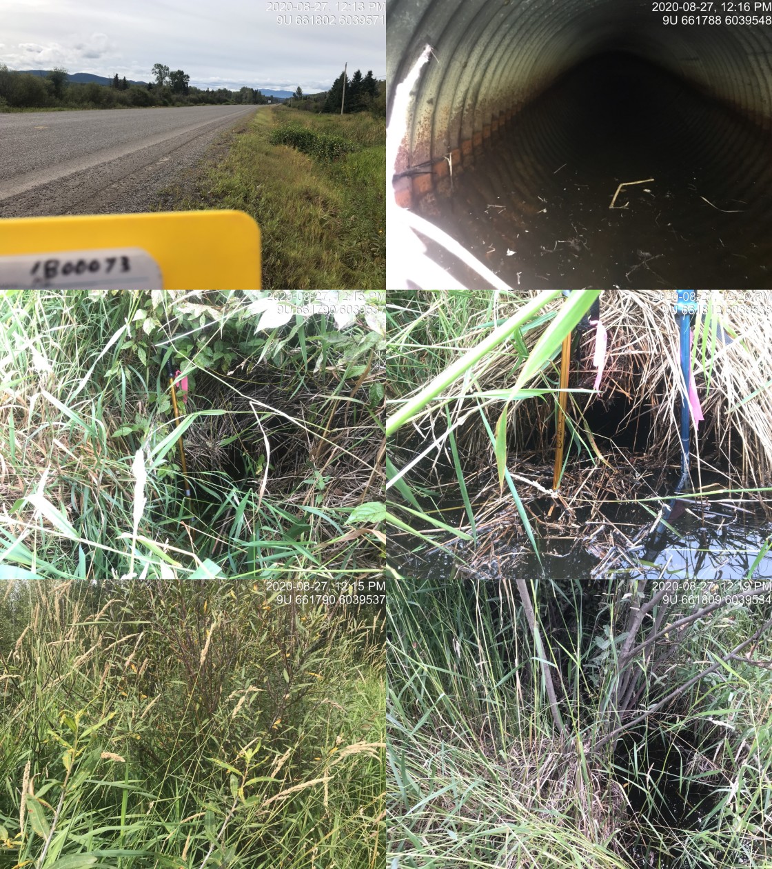
|
|||
| Comments: Small ditch likely modified due to adjacent agriculture. Culvert fully passabel at the time of the survey because backwatered 100%. Grasses around inlet and outlet make locating the culvert challenging. |
| Location and Stream Data |
|
Crossing Characteristics | – |
|---|---|---|---|
| Date | 2020-08-27 | Crossing Sub Type | Round Culvert |
| PSCIS ID | 197656 | Diameter (m) | 0.8 |
| External ID | 1800071 | Length (m) | 25 |
| Crew | AI, KP | Embedded | No |
| UTM Zone | 9 | Depth Embedded (m) | – |
| Easting | 663216 | Resemble Channel | No |
| Northing | 6042012 | Backwatered | Yes |
| Stream | Tributary to Bulkley River | Percent Backwatered | 100 |
| Road | Highway 16 | Fill Depth (m) | 1.8 |
| Road Tenure | MoTi highway | Outlet Drop (m) | 0 |
| Channel Width (m) | 5 | Outlet Pool Depth (m) | 0.5 |
| Stream Slope (%) | 0 | Inlet Drop | Yes |
| Beaver Activity | Yes | Slope (%) | 0 |
| Habitat Value | Low | Valley Fill | Deep Fill |
| Final score | 19 | Barrier Result | Potential |
| Fix type | Replace with New Open Bottom Structure | Fix Span / Diameter | 10 |
Photos: PSCIS ID 197656. From top left clockwise: Road/Site Card, Barrel, Outlet, Downstream, Upstream, Inlet.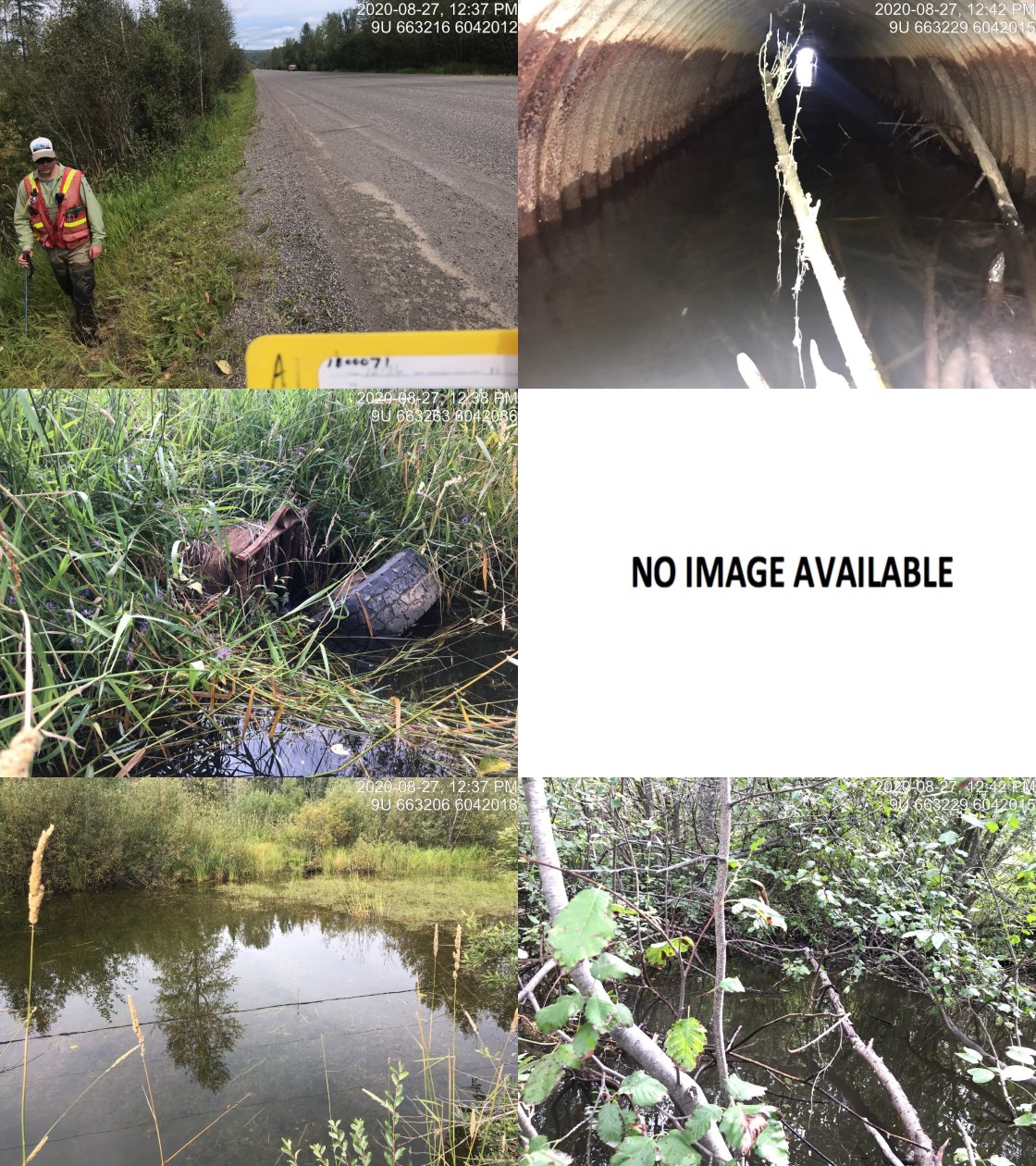
|
|||
| Comments: Possible value for coho rearing. Downstream CNRail crossing could not be located at time of assessment. Tire at inlet. |
| Location and Stream Data |
|
Crossing Characteristics | – |
|---|---|---|---|
| Date | 2020-08-27 | Crossing Sub Type | Round Culvert |
| PSCIS ID | 197657 | Diameter (m) | 2.5 |
| External ID | 1800064 | Length (m) | 14 |
| Crew | AI, KP | Embedded | No |
| UTM Zone | 9 | Depth Embedded (m) | – |
| Easting | 665609 | Resemble Channel | Yes |
| Northing | 6044135 | Backwatered | No |
| Stream | Perow Creek | Percent Backwatered | – |
| Road | Highway 16 | Fill Depth (m) | 1 |
| Road Tenure | MoTi highway | Outlet Drop (m) | 0 |
| Channel Width (m) | 3.2 | Outlet Pool Depth (m) | 0.2 |
| Stream Slope (%) | 1.5 | Inlet Drop | No |
| Beaver Activity | No | Slope (%) | 2.5 |
| Habitat Value | High | Valley Fill | Deep Fill |
| Final score | 18 | Barrier Result | Potential |
| Fix type | Replace with New Open Bottom Structure | Fix Span / Diameter | 10 |
Photos: PSCIS ID 197657. From top left clockwise: Road/Site Card, Barrel, Outlet, Downstream, Upstream, Inlet.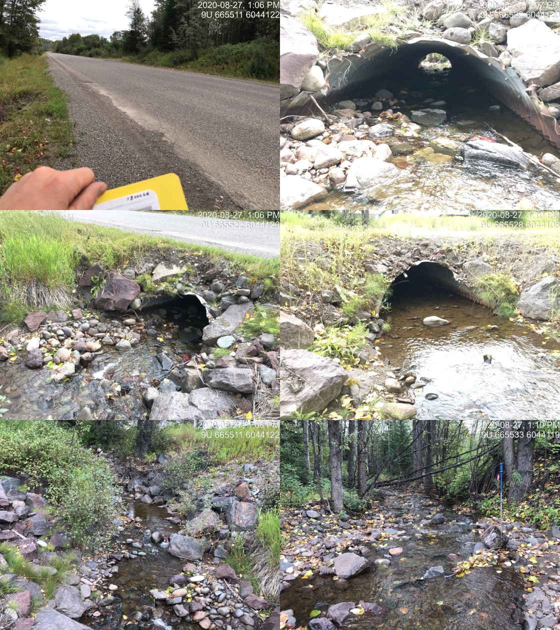
|
|||
| Comments: Culvert is likely as passable as natural channel for all species and life stages at most flows. |
| Location and Stream Data |
|
Crossing Characteristics | – |
|---|---|---|---|
| Date | 2020-08-27 | Crossing Sub Type | Oval Culvert |
| PSCIS ID | 197658 | Diameter (m) | 4 |
| External ID | 1800062 | Length (m) | 24 |
| Crew | AI, KP | Embedded | No |
| UTM Zone | 9 | Depth Embedded (m) | – |
| Easting | 666847.2 | Resemble Channel | No |
| Northing | 6044305 | Backwatered | No |
| Stream | Byman Creek | Percent Backwatered | – |
| Road | Highway 16 | Fill Depth (m) | 1.6 |
| Road Tenure | MoTi highway | Outlet Drop (m) | 2 |
| Channel Width (m) | 11.1 | Outlet Pool Depth (m) | 3.8 |
| Stream Slope (%) | 1.2 | Inlet Drop | Yes |
| Beaver Activity | No | Slope (%) | 4 |
| Habitat Value | High | Valley Fill | Deep Fill |
| Final score | 39 | Barrier Result | Barrier |
| Fix type | Replace with New Open Bottom Structure | Fix Span / Diameter | 15.1 |
Photos: PSCIS ID 197658. From top left clockwise: Road/Site Card, Barrel, Outlet, Downstream, Upstream, Inlet.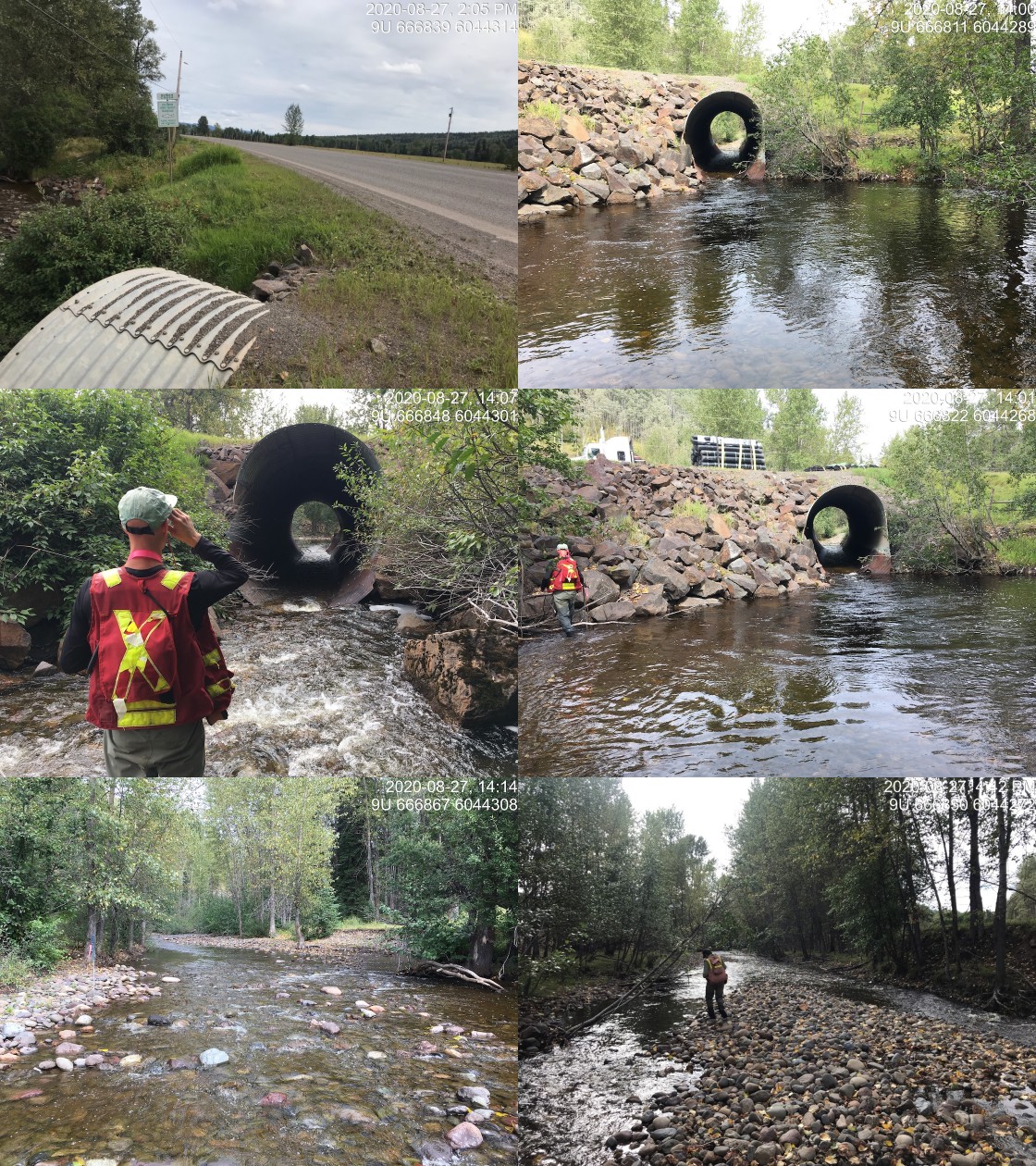
|
|||
| Comments: Culvert is likely as passable for most species and life stages at most non-peak and non-lowest flows. Streamkeepers have observed fry moving through culvert in overwintering studies. |
| Location and Stream Data |
|
Crossing Characteristics | – |
|---|---|---|---|
| Date | 2020-08-27 | Crossing Sub Type | Concrete Box |
| PSCIS ID | 197659 | Diameter (m) | 3.2 |
| External ID | 1800066 | Length (m) | 8 |
| Crew | AI, KP | Embedded | Yes |
| UTM Zone | 9 | Depth Embedded (m) | 1 |
| Easting | 665586.4 | Resemble Channel | Yes |
| Northing | 6043993 | Backwatered | No |
| Stream | Perow Creek | Percent Backwatered | – |
| Road | CN Railway | Fill Depth (m) | 0 |
| Road Tenure | Canadian National | Outlet Drop (m) | 0 |
| Channel Width (m) | 3.2 | Outlet Pool Depth (m) | 0 |
| Stream Slope (%) | 2 | Inlet Drop | No |
| Beaver Activity | No | Slope (%) | 0 |
| Habitat Value | High | Valley Fill | Deep Fill |
| Final score | 3 | Barrier Result | Passable |
| Fix type | – | Fix Span / Diameter | – |
Photos: PSCIS ID 197659. From top left clockwise: Road/Site Card, Barrel, Outlet, Downstream, Upstream, Inlet.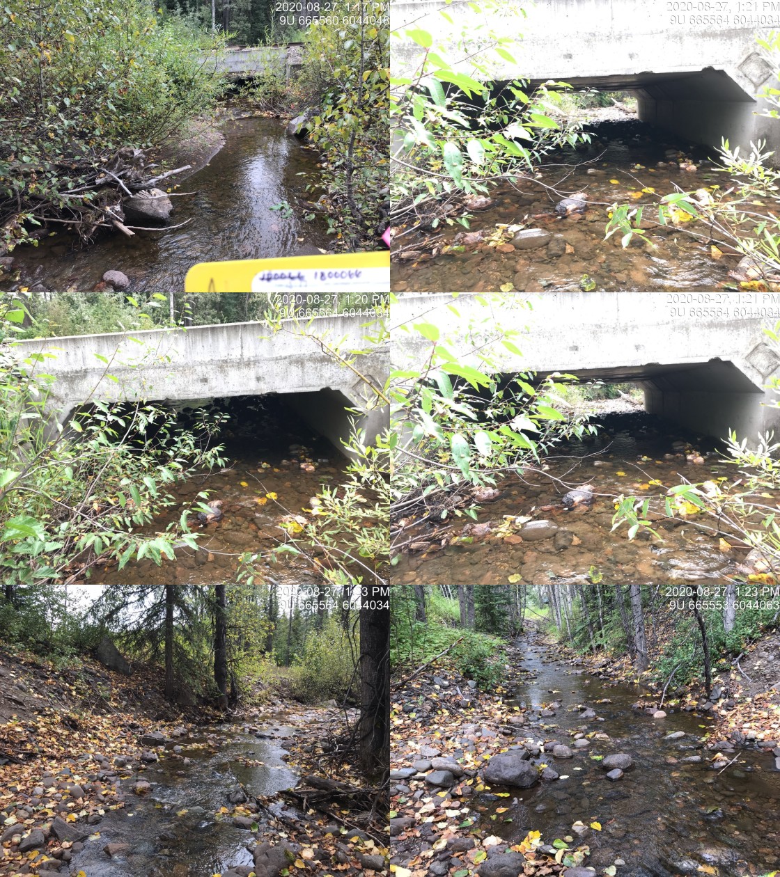
|
|||
| Comments: Appears passable. No concerns. |
| Location and Stream Data |
|
Crossing Characteristics | – |
|---|---|---|---|
| Date | 2020-08-27 | Crossing Sub Type | Bridge |
| PSCIS ID | 197660 | Diameter (m) | 5 |
| External ID | 1805595 | Length (m) | 18 |
| Crew | AI, KP | Embedded | – |
| UTM Zone | 9 | Depth Embedded (m) | – |
| Easting | 665623.6 | Resemble Channel | – |
| Northing | 6044045 | Backwatered | – |
| Stream | Byman Creek | Percent Backwatered | – |
| Road | CN Railway | Fill Depth (m) | – |
| Road Tenure | Canadian National | Outlet Drop (m) | – |
| Channel Width (m) | – | Outlet Pool Depth (m) | – |
| Stream Slope (%) | – | Inlet Drop | – |
| Beaver Activity | No | Slope (%) | – |
| Habitat Value | – | Valley Fill | – |
| Final score | 3 | Barrier Result | Passable |
| Fix type | – | Fix Span / Diameter | – |
Photos: PSCIS ID 197660. From top left clockwise: Road/Site Card, Barrel, Outlet, Downstream, Upstream, Inlet.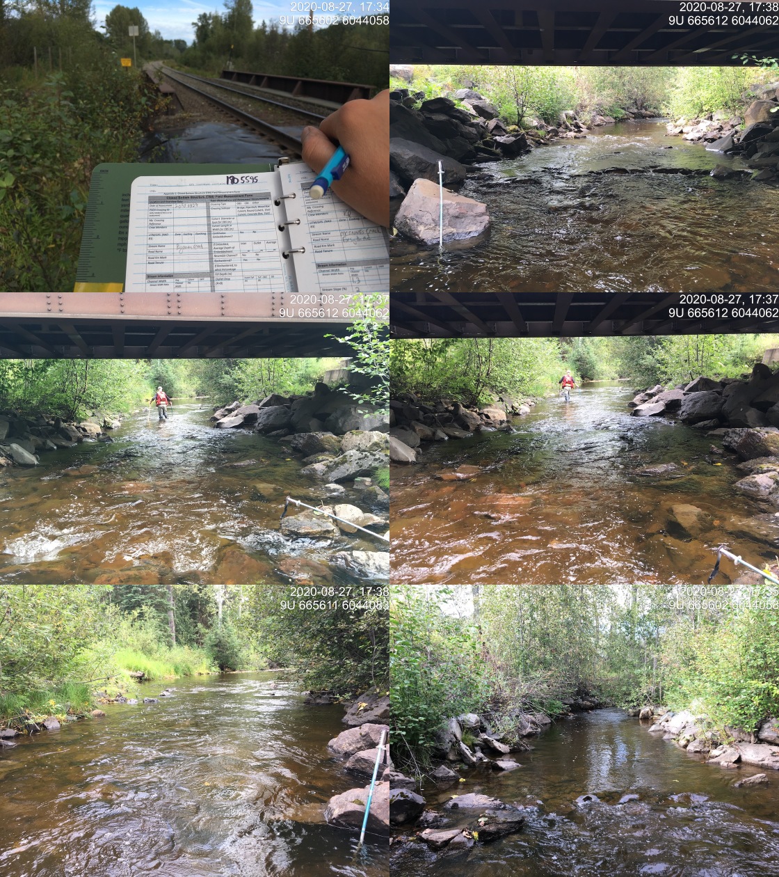
|
|||
| Comments: Appears passable. No concerns. |
| Location and Stream Data |
|
Crossing Characteristics | – |
|---|---|---|---|
| Date | 2020-08-27 | Crossing Sub Type | Bridge |
| PSCIS ID | 197661 | Diameter (m) | 4 |
| External ID | 2020082701 | Length (m) | 10 |
| Crew | KP, AI | Embedded | – |
| UTM Zone | 9 | Depth Embedded (m) | – |
| Easting | 665574 | Resemble Channel | – |
| Northing | 6043989 | Backwatered | – |
| Stream | Perow Creek | Percent Backwatered | – |
| Road | Perow Station Rd | Fill Depth (m) | – |
| Road Tenure | MoTi local | Outlet Drop (m) | – |
| Channel Width (m) | – | Outlet Pool Depth (m) | – |
| Stream Slope (%) | – | Inlet Drop | – |
| Beaver Activity | No | Slope (%) | – |
| Habitat Value | – | Valley Fill | – |
| Final score | 0 | Barrier Result | Passable |
| Fix type | – | Fix Span / Diameter | – |
Photos: PSCIS ID 197661. From top left clockwise: Road/Site Card, Barrel, Outlet, Downstream, Upstream, Inlet.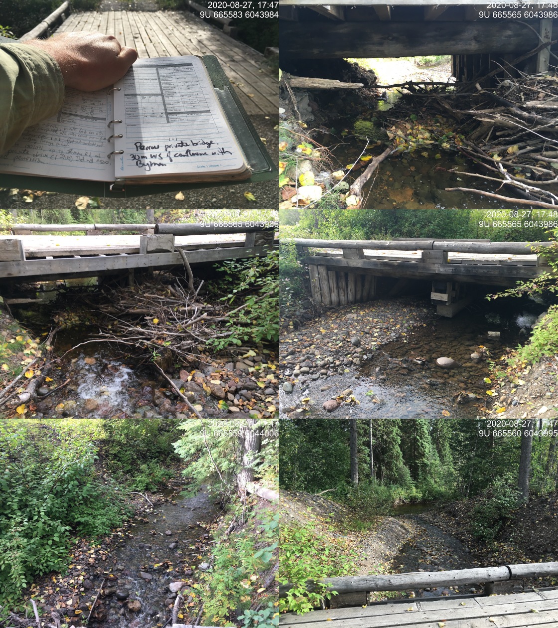
|
|||
| Comments: Private bridge approximately 30 upstrea of confulence with Byman Creek. |
| Location and Stream Data |
|
Crossing Characteristics | – |
|---|---|---|---|
| Date | 2020-08-28 | Crossing Sub Type | Round Culvert |
| PSCIS ID | 197662 | Diameter (m) | 4.2 |
| External ID | 1800060 | Length (m) | 24 |
| Crew | KP, AI | Embedded | No |
| UTM Zone | 9 | Depth Embedded (m) | – |
| Easting | 672404.7 | Resemble Channel | No |
| Northing | 6044146 | Backwatered | No |
| Stream | Richfield Creek | Percent Backwatered | – |
| Road | Highway 16 | Fill Depth (m) | 1 |
| Road Tenure | MoTi highway | Outlet Drop (m) | 0.2 |
| Channel Width (m) | 12.5 | Outlet Pool Depth (m) | 1 |
| Stream Slope (%) | 1.5 | Inlet Drop | No |
| Beaver Activity | No | Slope (%) | 2 |
| Habitat Value | High | Valley Fill | Deep Fill |
| Final score | 29 | Barrier Result | Barrier |
| Fix type | Replace with New Open Bottom Structure | Fix Span / Diameter | 16.5 |
Photos: PSCIS ID 197662. From top left clockwise: Road/Site Card, Barrel, Outlet, Downstream, Upstream, Inlet.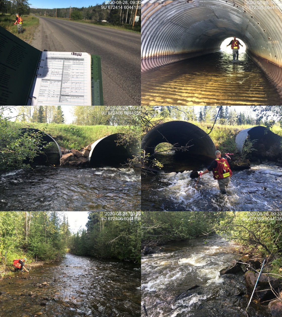
|
|||
| Comments: Habitat confirmation and minnowtrapping completed. |
| Location and Stream Data |
|
Crossing Characteristics | – |
|---|---|---|---|
| Date | 2020-08-28 | Crossing Sub Type | Round Culvert |
| PSCIS ID | 197663 | Diameter (m) | 1.75 |
| External ID | 1800213 | Length (m) | 25 |
| Crew | KP, AI | Embedded | No |
| UTM Zone | 9 | Depth Embedded (m) | – |
| Easting | 670240.8 | Resemble Channel | No |
| Northing | 6044772 | Backwatered | No |
| Stream | Johnny David Creek | Percent Backwatered | – |
| Road | Highway 16 | Fill Depth (m) | 3 |
| Road Tenure | MoTi highway | Outlet Drop (m) | 0 |
| Channel Width (m) | 6.3 | Outlet Pool Depth (m) | 1.35 |
| Stream Slope (%) | 5.5 | Inlet Drop | Yes |
| Beaver Activity | No | Slope (%) | 2 |
| Habitat Value | High | Valley Fill | Deep Fill |
| Final score | 24 | Barrier Result | Barrier |
| Fix type | Replace with New Open Bottom Structure | Fix Span / Diameter | 10.3 |
Photos: PSCIS ID 197663. From top left clockwise: Road/Site Card, Barrel, Outlet, Downstream, Upstream, Inlet.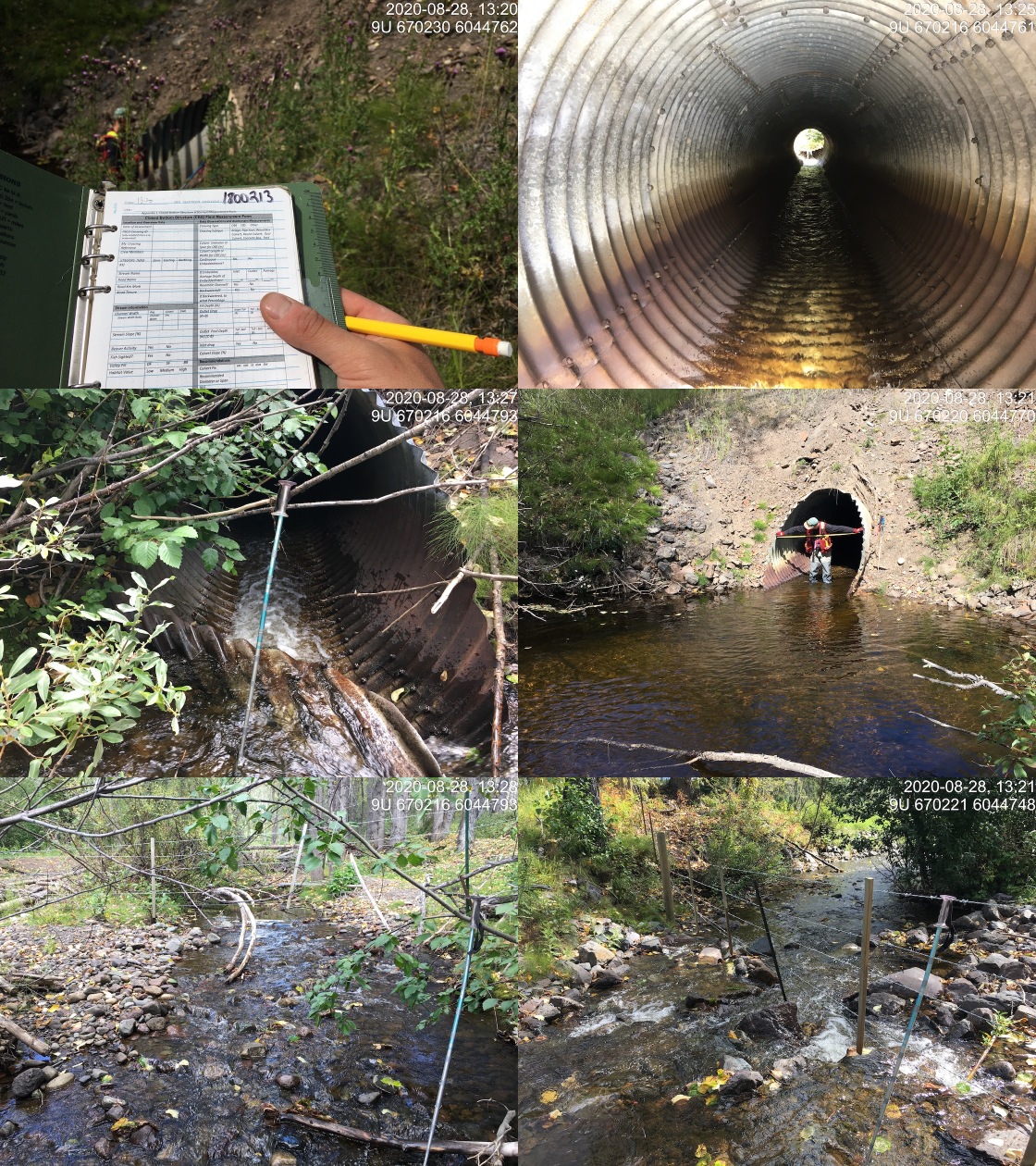
|
|||
| Comments: Habitat confirmation and sampling completed. |
| Location and Stream Data |
|
Crossing Characteristics | – |
|---|---|---|---|
| Date | 2020-08-28 | Crossing Sub Type | Round Culvert |
| PSCIS ID | 197664 | Diameter (m) | 2.5 |
| External ID | 1801069 | Length (m) | 15 |
| Crew | KP, AI | Embedded | Yes |
| UTM Zone | 9 | Depth Embedded (m) | 1.9 |
| Easting | 660454.3 | Resemble Channel | Yes |
| Northing | 6037919 | Backwatered | No |
| Stream | Barren Creek | Percent Backwatered | – |
| Road | Highway 16 | Fill Depth (m) | 1 |
| Road Tenure | MoTi highway | Outlet Drop (m) | 0 |
| Channel Width (m) | 4.7 | Outlet Pool Depth (m) | 0 |
| Stream Slope (%) | 1.8 | Inlet Drop | No |
| Beaver Activity | Yes | Slope (%) | 2 |
| Habitat Value | High | Valley Fill | Deep Fill |
| Final score | 14 | Barrier Result | Passable |
| Fix type | – | Fix Span / Diameter | – |
Photos: PSCIS ID 197664. From top left clockwise: Road/Site Card, Barrel, Outlet, Downstream, Upstream, Inlet.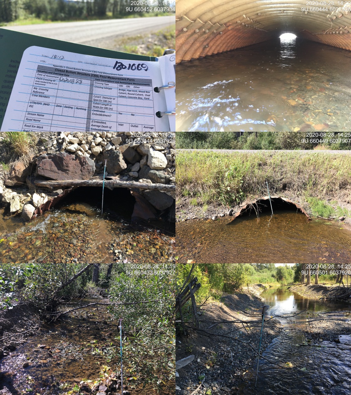
|
|||
| Comments: Habitat confirmation completed. |
| Location and Stream Data |
|
Crossing Characteristics | – |
|---|---|---|---|
| Date | 2020-08-28 | Crossing Sub Type | Round Culvert |
| PSCIS ID | 197665 | Diameter (m) | 0.9 |
| External ID | 1800076 | Length (m) | 25 |
| Crew | AI, KP | Embedded | Yes |
| UTM Zone | 9 | Depth Embedded (m) | 0.3 |
| Easting | 660627 | Resemble Channel | Yes |
| Northing | 6037843 | Backwatered | Yes |
| Stream | Barren Creek | Percent Backwatered | 10 |
| Road | CN Railway | Fill Depth (m) | 2 |
| Road Tenure | Canadian National | Outlet Drop (m) | 0 |
| Channel Width (m) | 3.5 | Outlet Pool Depth (m) | 0.4 |
| Stream Slope (%) | 3 | Inlet Drop | No |
| Beaver Activity | No | Slope (%) | 1 |
| Habitat Value | High | Valley Fill | Deep Fill |
| Final score | 14 | Barrier Result | Passable |
| Fix type | – | Fix Span / Diameter | – |
Photos: PSCIS ID 197665. From top left clockwise: Road/Site Card, Barrel, Outlet, Downstream, Upstream, Inlet.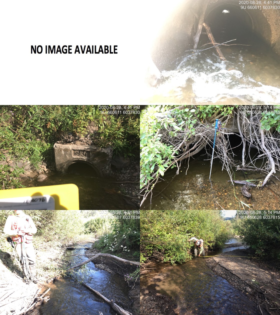
|
|||
| Comments: Date on structure is 1934. Two pipes presetn but only one of two pipes functional at time of survey. Functonal pipe is apparently collapsing. Oxidized ooze at outlet of eastern dewatered pipe. |
| Location and Stream Data |
|
Crossing Characteristics | – |
|---|---|---|---|
| Date | 2020-08-29 | Crossing Sub Type | Round Culvert |
| PSCIS ID | 197666 | Diameter (m) | 2 |
| External ID | 2020083101 | Length (m) | 22 |
| Crew | AI, KP | Embedded | Yes |
| UTM Zone | 9 | Depth Embedded (m) | 0.15 |
| Easting | 628108 | Resemble Channel | Yes |
| Northing | 6059632 | Backwatered | Yes |
| Stream | Helps Creek | Percent Backwatered | 100 |
| Road | CN Railway | Fill Depth (m) | 1 |
| Road Tenure | Canadian National | Outlet Drop (m) | 0 |
| Channel Width (m) | 6 | Outlet Pool Depth (m) | 0.3 |
| Stream Slope (%) | 0 | Inlet Drop | No |
| Beaver Activity | Yes | Slope (%) | 0 |
| Habitat Value | High | Valley Fill | Deep Fill |
| Final score | 14 | Barrier Result | Passable |
| Fix type | – | Fix Span / Diameter | – |
Photos: PSCIS ID 197666. From top left clockwise: Road/Site Card, Barrel, Outlet, Downstream, Upstream, Inlet.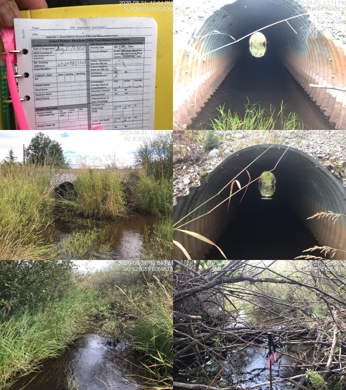
|
|||
| Comments: Passable and fully backwatered structure. Landowner reports that lamprey (~40cm x 20) at crossing inside of the culvert in the past. |
| Location and Stream Data |
|
Crossing Characteristics | – |
|---|---|---|---|
| Date | 2020-08-31 | Crossing Sub Type | Round Culvert |
| PSCIS ID | 197667 | Diameter (m) | 2.5 |
| External ID | 1805606 | Length (m) | 17 |
| Crew | KP, AI | Embedded | No |
| UTM Zone | 9 | Depth Embedded (m) | – |
| Easting | 631092 | Resemble Channel | No |
| Northing | 6055866 | Backwatered | No |
| Stream | Moan Creek | Percent Backwatered | – |
| Road | CN Railway | Fill Depth (m) | 0.8 |
| Road Tenure | Canadian National | Outlet Drop (m) | 0.58 |
| Channel Width (m) | 3.8 | Outlet Pool Depth (m) | 0.57 |
| Stream Slope (%) | 4.5 | Inlet Drop | No |
| Beaver Activity | No | Slope (%) | 4 |
| Habitat Value | High | Valley Fill | Deep Fill |
| Final score | 39 | Barrier Result | Barrier |
| Fix type | Replace with New Open Bottom Structure | Fix Span / Diameter | 10 |
Photos: PSCIS ID 197667. From top left clockwise: Road/Site Card, Barrel, Outlet, Downstream, Upstream, Inlet.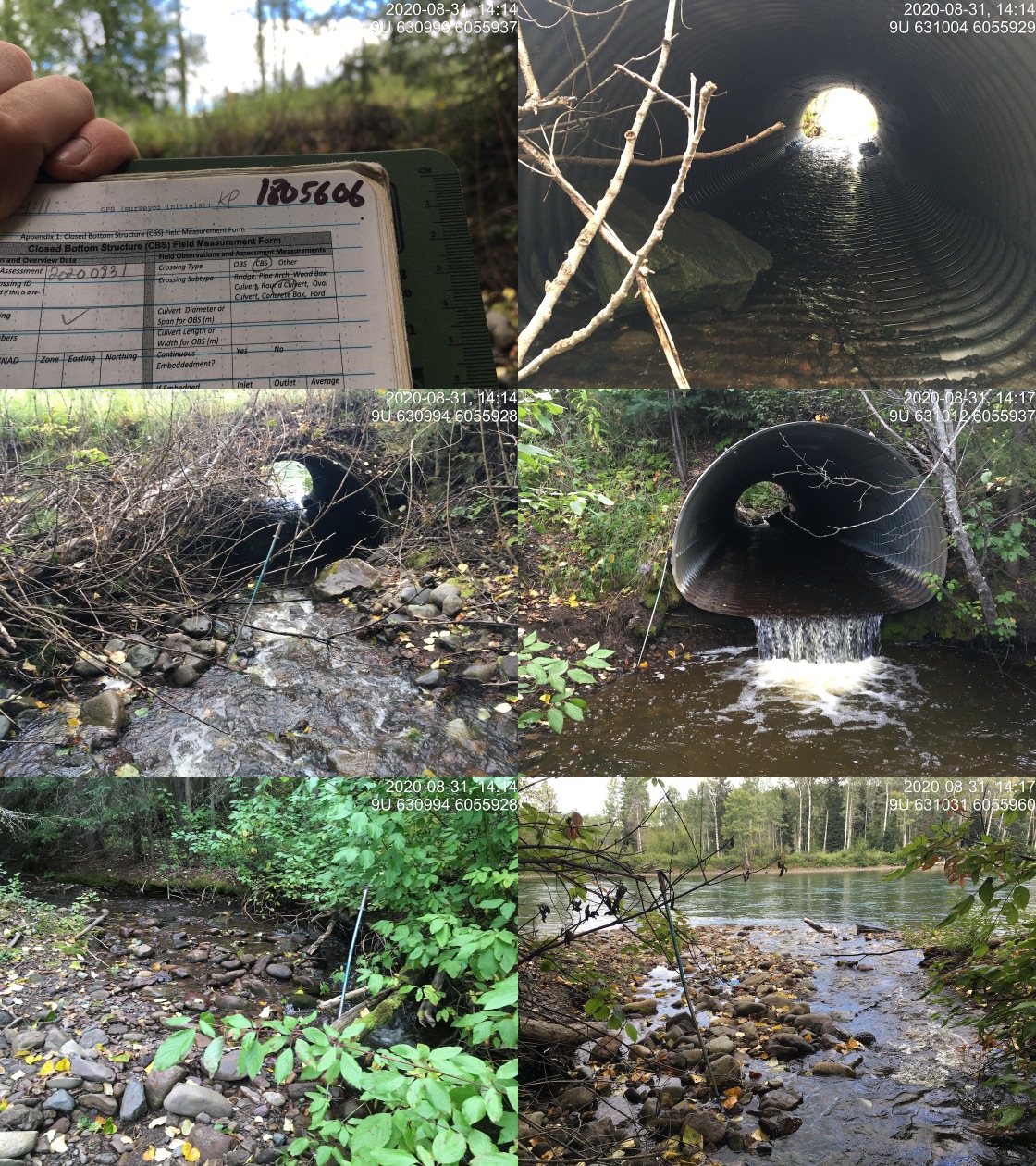
|
|||
| Comments: Approximately 17m from the outlet to the Bulkley River. |
| Location and Stream Data |
|
Crossing Characteristics | – |
|---|---|---|---|
| Date | 2020-08-31 | Crossing Sub Type | Round Culvert |
| PSCIS ID | 197668 | Diameter (m) | 3 |
| External ID | 1805608 | Length (m) | 15 |
| Crew | KP, AI | Embedded | No |
| UTM Zone | 9 | Depth Embedded (m) | – |
| Easting | 634336 | Resemble Channel | No |
| Northing | 6054609 | Backwatered | No |
| Stream | Coffin Creek | Percent Backwatered | – |
| Road | CN Railway | Fill Depth (m) | 0.8 |
| Road Tenure | Canadian National | Outlet Drop (m) | 0.27 |
| Channel Width (m) | 5.3 | Outlet Pool Depth (m) | 0.47 |
| Stream Slope (%) | 2 | Inlet Drop | No |
| Beaver Activity | No | Slope (%) | 2 |
| Habitat Value | High | Valley Fill | Deep Fill |
| Final score | 29 | Barrier Result | Barrier |
| Fix type | Replace with New Open Bottom Structure | Fix Span / Diameter | 10 |
Photos: PSCIS ID 197668. From top left clockwise: Road/Site Card, Barrel, Outlet, Downstream, Upstream, Inlet.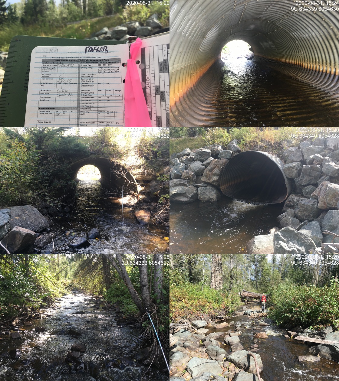
|
|||
| Comments: CN crossing has had Newbury riffles constructed to decrease the size of the outlet drop but drop still present. Abundant gravels suitable for spawning chinook and coho present. Some deep pools available for fry/parr overwintering. |
| Location and Stream Data |
|
Crossing Characteristics | – |
|---|---|---|---|
| Date | 2020-09-05 | Crossing Sub Type | Round Culvert |
| PSCIS ID | 197669 | Diameter (m) | 1.25 |
| External ID | 14000079 | Length (m) | 6 |
| Crew | AI, KP | Embedded | No |
| UTM Zone | 9 | Depth Embedded (m) | – |
| Easting | 650567 | Resemble Channel | No |
| Northing | 5993274 | Backwatered | No |
| Stream | Riddeck Creek | Percent Backwatered | – |
| Road | Private | Fill Depth (m) | 0.3 |
| Road Tenure | unclassified | Outlet Drop (m) | 0.45 |
| Channel Width (m) | 2.6 | Outlet Pool Depth (m) | 0.7 |
| Stream Slope (%) | 4 | Inlet Drop | No |
| Beaver Activity | No | Slope (%) | 2 |
| Habitat Value | High | Valley Fill | Deep Fill |
| Final score | 31 | Barrier Result | Barrier |
| Fix type | Replace with New Open Bottom Structure | Fix Span / Diameter | 10 |
Photos: PSCIS ID 197669. From top left clockwise: Road/Site Card, Barrel, Outlet, Downstream, Upstream, Inlet.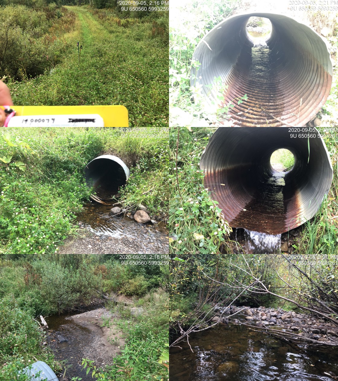
|
|||
| Comments: Extensive rearing habitat and gravels suitable for spawning. Stream eventually flows into top end of Owen Lake. |