Beaverley Creek - 199232 - Appendix
Site Location
PSCIS crossing 199232 is located on Beaverley Creek, approximately 14km west of Prince George, BC, in the Lower Chilako River watershed group (Figure 5.26). The crossing is 1.9km upstream of Beaverley Creek’s confluence with the Chilako River, the later of which flows into the Nechako River. It is situated on Highway 16 and falls under the responsibility of the Ministry of Transportation and Infrastructure (chris_hwy_structure_road_id: 4167).
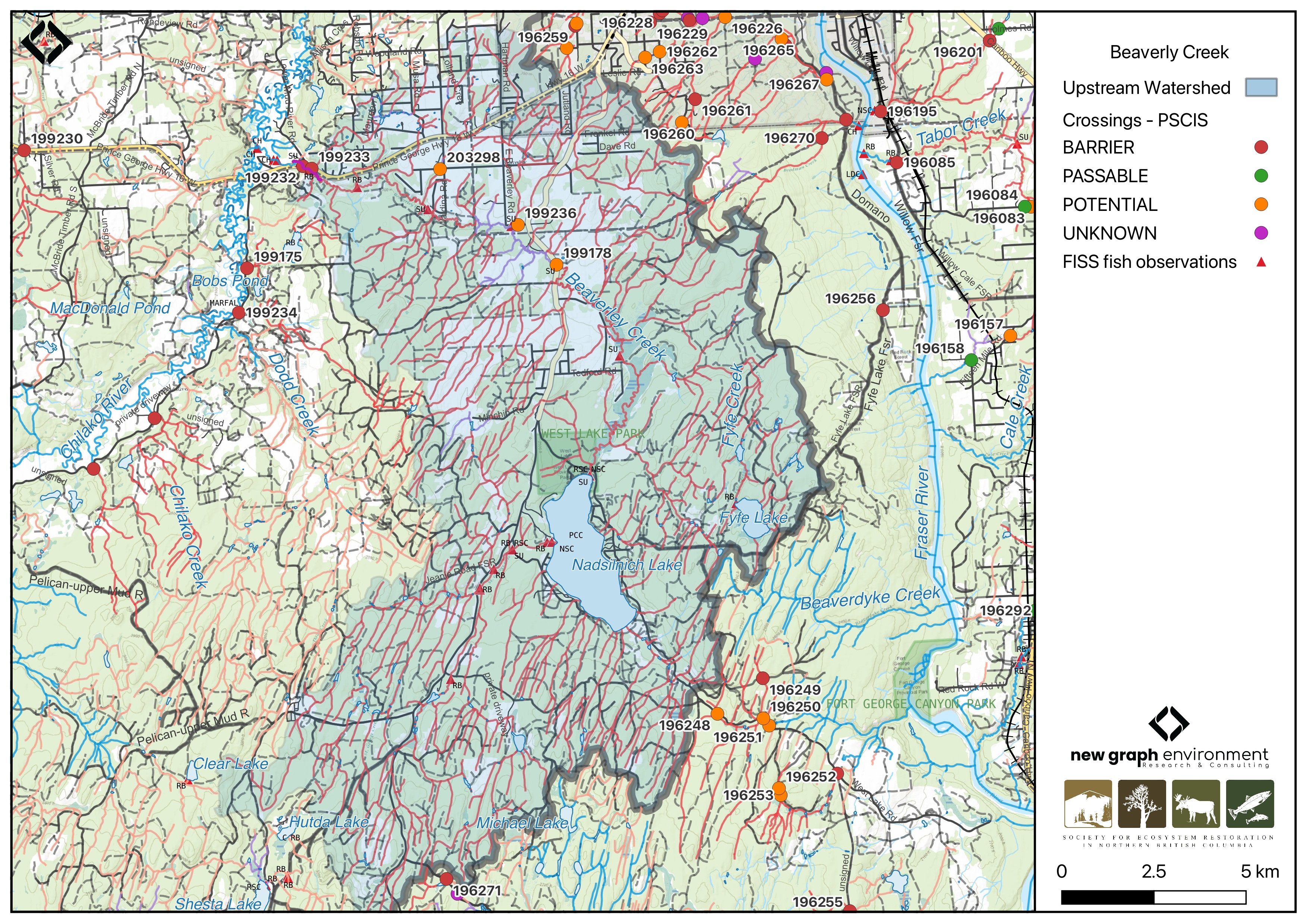
Figure 5.26: Map of Beaverly Creek
Background
At the location of PSCIS crossing 199232, Beaverley Creek is a fifth order stream and drains a watershed of approximately 215.6km2. The watershed ranges in elevation from a maximum of 1079m to 638m near the crossing (Table 5.25).
In 2023, PSCIS crossing 199232 on Highway 16 was assessed with a fish passage assessment and prioritized for follow-up due to the presence of high-value habitat and several historical chinook observations documented downstream in the FISS database (MoE 2024). A habitat confirmation assessment was subsequently conducted in 2024. Several other crossings were assessed within the Beaverley Creek system in 2023, with results detailed in Appendix - Phase 1 Fish Passage Assessment Data and Photos.
Chinook fry were captured downstream of the crossing in 2010 and 2004 by members from Vancouver Island University (Godfreyson 2010; Hobson 2004). Upstream of Highway 16, sucker (general), longnose sucker, largescale sucker, chub (general), peamouth chub, northern pikeminnow, longnose dace, redside shiner, burbot, rainbow trout, kokanee, chinook salmon, mountain whitefish, dolly varden, and prickly sculpin have previously been recorded (Norris [2018] 2024; MoE 2024).
A summary of habitat modelling outputs for the crossing are presented in Table 5.26.
fpr::fpr_table_wshd_sum(site_id = my_site) |>
  fpr::fpr_kable(caption_text = paste0('Summary of derived upstream watershed statistics for PSCIS crossing ', my_site, '.'),
           footnote_text = 'Elev P60 = Elevation at which 60% of the watershed area is above',
scroll = F)| Site | Area Km | Elev Site | Elev Min | Elev Max | Elev Median | Elev P60 | Aspect |
|---|---|---|---|---|---|---|---|
| 199232 | 215.6 | 638 | 579 | 1079 | 763 | 748 | S |
| * Elev P60 = Elevation at which 60% of the watershed area is above |
| Habitat | Potential | Remediation Gain | Remediation Gain (%) |
|---|---|---|---|
| CH Spawning (km) | 10.7 | 3.8 | 36 |
| CH Rearing (km) | 43.1 | 3.9 | 9 |
| CO Spawning (km) | 46.9 | 3.9 | 8 |
| CO Rearing (km) | 111.2 | 4.4 | 4 |
| CO Rearing (ha) | 0.0 | 0.0 | – |
| SK Spawning (km) | 0.0 | 0.0 | – |
| SK Rearing (km) | 0.0 | 0.0 | – |
| SK Rearing (ha) | 0.0 | 0.0 | – |
| BT Rearing (km) | 127.8 | 4.4 | 3 |
| BT Spawning (km) | 46.9 | 3.9 | 8 |
| * Model data is preliminary and subject to adjustments. |
Stream Characteristics at Crossing 199232
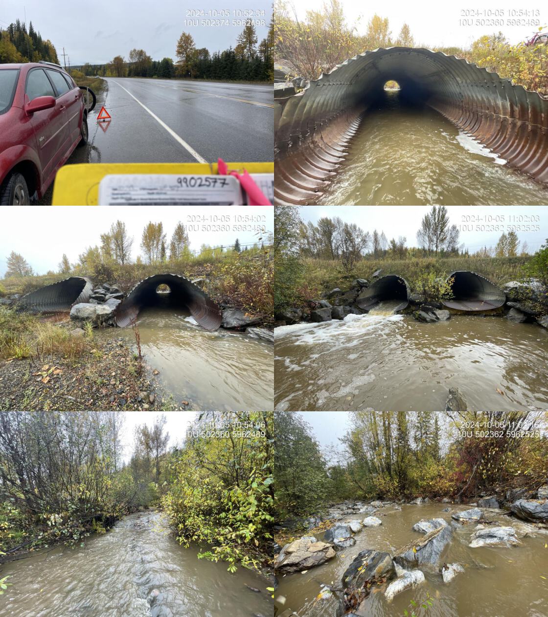
At the time of the 2024 assessment, PSCIS crossing 199232 on Highway 16 was un-embedded, non-backwatered and ranked as barrier to upstream fish passage according to the provincial protocol (MoE 2011) (Table 5.27). Two 2.8m diameter pipes were present, with no flow observed in the more northern pipe. The culverts had a significant 1.05m outlet drop.
The water temperature was 5\(^\circ\)C, pH was 8.2 and conductivity was 230 uS/cm.
# fpr::fpr_table_cv_summary_memo()

# See issue https://github.com/NewGraphEnvironment/mybookdown-template/issues/65
fpr::fpr_table_cv_summary_memo()| Location and Stream Data |
|
Crossing Characteristics | – |
|---|---|---|---|
| Date | 2024-10-05 | Crossing Sub Type | Oval Culvert |
| PSCIS ID | 199232 | Diameter (m) | 5.6 |
| External ID | – | Length (m) | 25 |
| Crew | LS | Embedded | No |
| UTM Zone | 10 | Depth Embedded (m) | – |
| Easting | 502374 | Resemble Channel | No |
| Northing | 5962501 | Backwatered | No |
| Stream | Beaverley Creek | Percent Backwatered | – |
| Road | Highway 16 | Fill Depth (m) | 1.5 |
| Road Tenure | MOti | Outlet Drop (m) | 1.05 |
| Channel Width (m) | 9.6 | Outlet Pool Depth (m) | 0.35 |
| Stream Slope (%) | 0.5 | Inlet Drop | No |
| Beaver Activity | No | Slope (%) | 2 |
| Habitat Value | Medium | Valley Fill | Deep Fill |
| Final score | 34 | Barrier Result | Barrier |
| Fix type | Replace with New Open Bottom Structure | Fix Span / Diameter | 15 |
| Comments: Two pipes, each 2.8m in diameter, were present. The pipe on the north side was not flowing. The gradient directly downstream of the culvert was 3–4% due to boulders placed to create backwatering, which was somewhat functioning, though the culverts were not fully backwatered, but water levels were elevated. The rest of the stream had a gradient of 0.5%. The stream provided good habitat but was fairly channelized due to residential development on both sides. Signs of high flows were evident, with eroding banks. Few pools and limited functional large woody debris were present. MoTi chris_hwy_structure_road_id: 4167 | |||
| Photos: From top left clockwise: Road/Site Card, Barrel, Outlet, Downstream, Upstream, Inlet. | |||
|
Stream Characteristics Downstream of Crossing 199232
The stream was surveyed downstream from crossing 199232 for 300m (Figure 5.27). The habitat was rated as medium value due to sparse large woody debris, a lack of pools, and high turbidity from recent rainfall likely obscuring gravels. Below the outlet, large boulders were placed in rows to backwater the culvert, which was somewhat effective, though the culvert itself remained unbackwatered. This section had a steeper gradient (3 – 4%) before transitioning to ~0.5% for the remainder of the area surveyed. The upper section of the stream was somewhat channelized due to residences on both sides, while lower sections showed significant bank erosion. The average channel width was 9.6m, the average wetted width was 6m, and the average gradient was 2%.Total cover amount was rated as moderate with large woody debris dominant. Cover was also present as boulders.The dominant substrate was cobbles with gravels sub-dominant.
Stream Characteristics Upstream of Crossing 199232
The stream was surveyed upstream from crossing 199232 for 725m (Figure 5.28). The habitat was rated as high value, with abundant gravels suitable for chinook spawning. Pools were infrequent, primarily located on outside bends and behind large woody debris. Some evidence of anthropogenic manipulation was observed, including cut cottonwood trees that had fallen into the channel. The riparian zone was in good condition, with mature shrub communities and old-growth cottonwood that should contribute to future habitat complexity. Water levels were elevated to moderate conditions due to heavy rainfall over the previous evening and preceding weeks. The average channel width was 11.9m, the average wetted width was 8m, and the average gradient was 0.6%.Total cover amount was rated as moderate with overhanging vegetation dominant. Cover was also present as small woody debris and boulders.The dominant substrate was gravels with cobbles sub-dominant.
Structure Remediation and Cost Estimate
Should restoration/maintenance activities proceed, replacement of the Highway 16 crossing (199232) with a bridge (15 m span) is recommended. At the time of reporting in 2025, the cost of the work is estimated at $ 11,250,000.
Conclusion
Beaverley Creek is a large stream and a major tributary to the Chilako River, with documented chinook observations downstream, most recently in 2010 (Godfreyson 2010). The areas surveyed upstream provided high-value habitat for chinook spawning, with bcfishpass modeling indicating ~11km of potential chinook and ~47km of potential coho spawning habitat upstream. Both culverts had a significant outlet drop, and the crossing is a high priority for replacement. The watershed is within Prince George city limits, presenting opportunities for community engagement, trail network development, educational programs, and stewardship initiatives.
tab_hab_summary |>
  dplyr::filter(Site %in% c(my_site)) |>
  fpr::fpr_kable(caption_text = paste0("Summary of habitat details for PSCIS crossing ", my_site, "."),
scroll = F) | Site | Location | Length Surveyed (m) | Average Channel Width (m) | Average Wetted Width (m) | Average Pool Depth (m) | Average Gradient (%) | Total Cover | Habitat Value |
|---|---|---|---|---|---|---|---|---|
| 199232 | Downstream | 300 | 9.6 | 6 | 0.4 | 2.0 | moderate | medium |
| 199232 | Upstream | 725 | 11.9 | 8 | 0.4 | 0.6 | moderate | high |
my_photo1 = fpr::fpr_photo_pull_by_str(str_to_pull = 'ds_typical_1_')

my_caption1 = paste0('Typical habitat downstream of PSCIS crossing ', my_site, '.')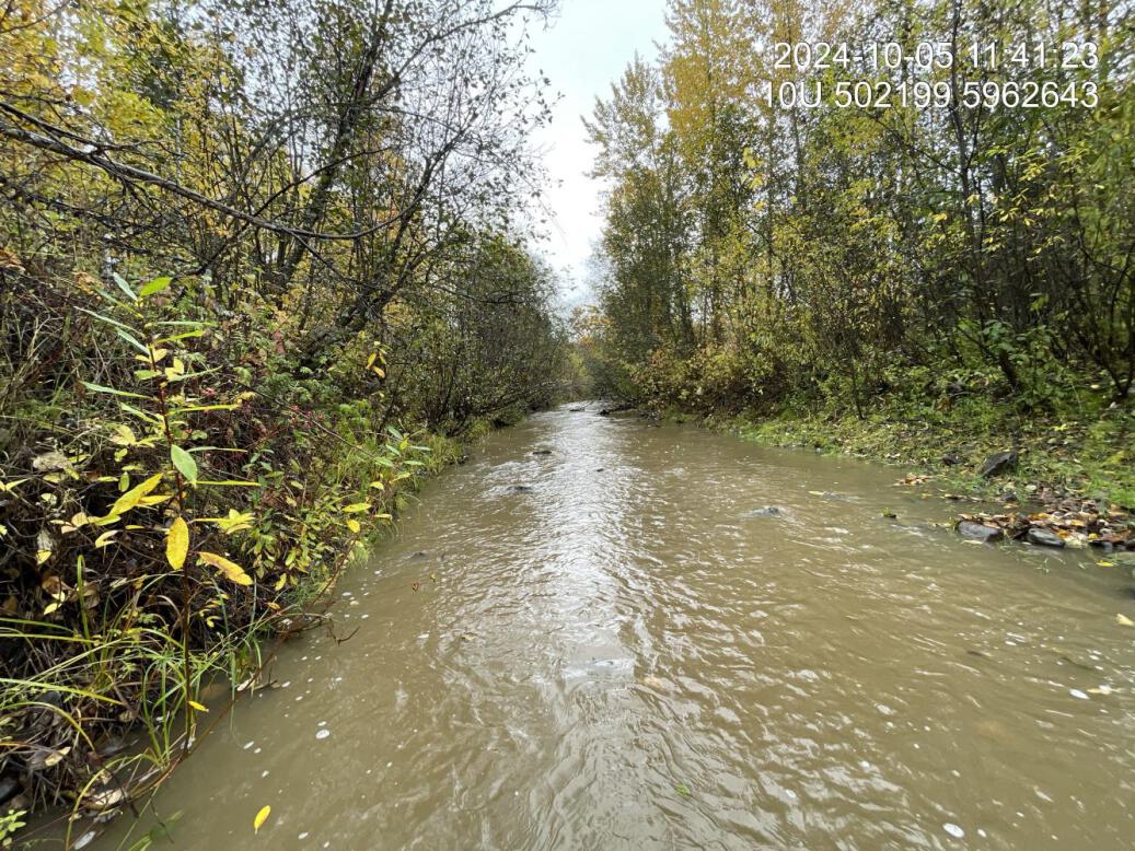
Figure 5.27: Typical habitat downstream of PSCIS crossing 199232.
my_photo2 = fpr::fpr_photo_pull_by_str(str_to_pull = 'us_typical_2_')

my_caption2 = paste0('Typical habitat upstream of PSCIS crossing ', my_site, '.')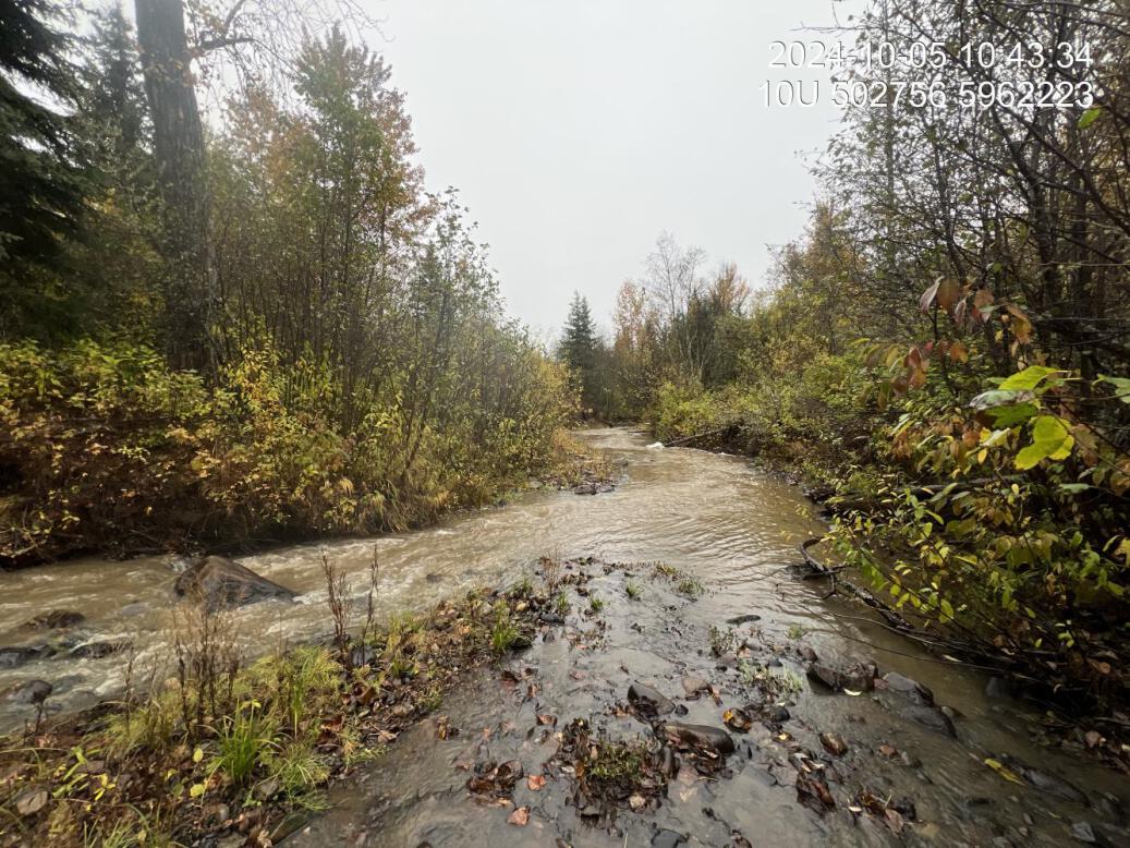
Figure 5.28: Typical habitat upstream of PSCIS crossing 199232.
my_caption <- paste0('Left: ', my_caption1, ' Right: ', my_caption2)

knitr::include_graphics(my_photo1)
knitr::include_graphics("fig/pixel.png")
knitr::include_graphics(my_photo2)