Holliday Creek - 199282 - Appendix
Site Location
PSCIS crossing 199282 is located on Holliday Creek, approximately 23km southeast of McBride, BC, in the Upper Fraser River watershed group (Figure 5.50). The crossing is located 2.4km upstream of where Holliday Creek joins the Fraser River. Situated on Highway 16, the crossing is the responsibility of the Ministry of Transportation and Infrastructure (chris_culvert_id: 29925).
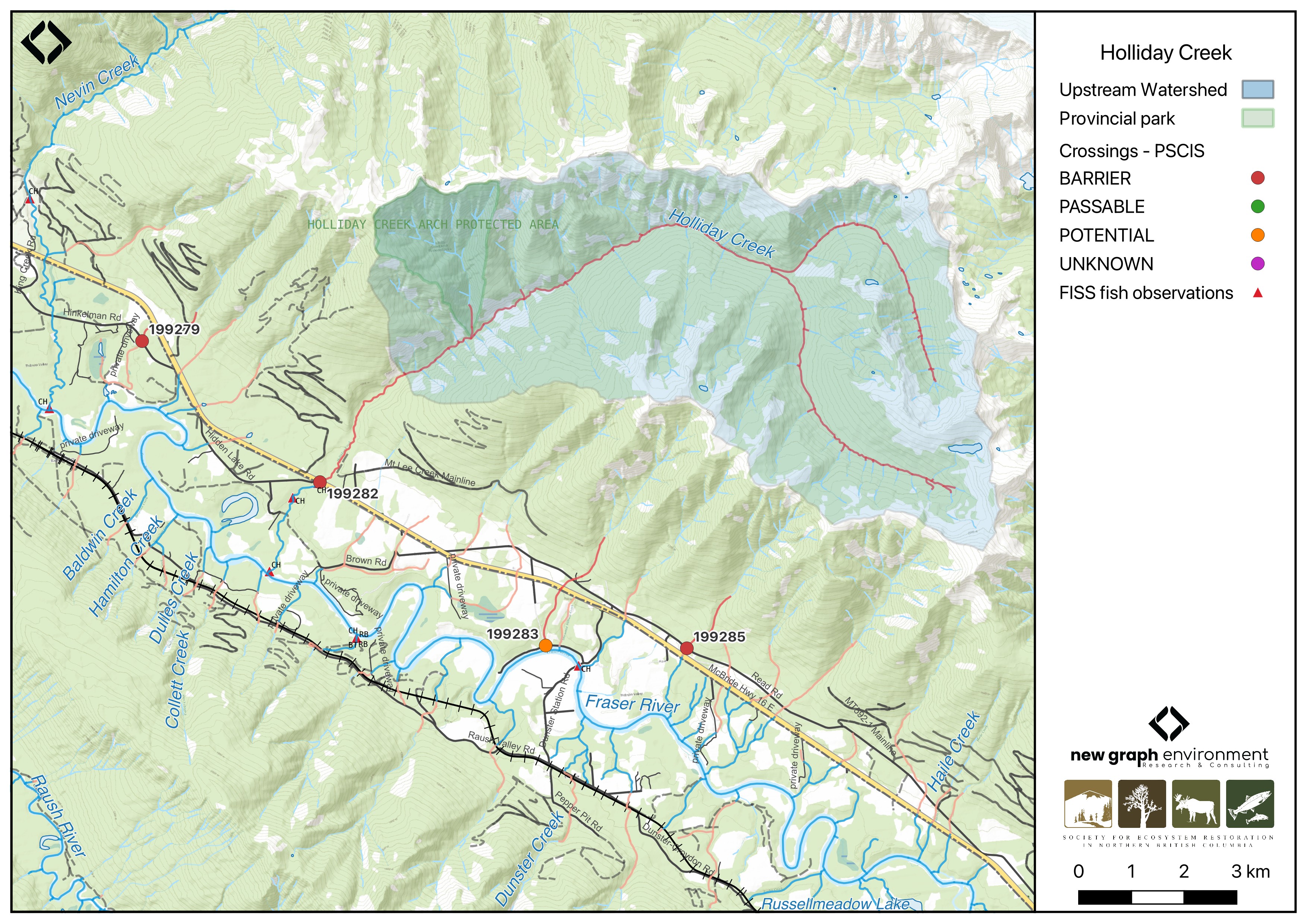
Figure 5.50: Map of Holliday Creek
Background
At PSCIS crossing 199282, Holliday Creek is a large, glaciated, fourth order stream that drains a high elevation watershed of approximately 55.2km2. The watershed ranges in elevation from a maximum of 2553m to 777m near the crossing (Table 5.54).
In 2023, crossing 199282 was assessed with a fish passage assessment and prioritized for follow-up due to the presence of high-value habitat and a historical chinook salmon observation recorded downstream in the FISS database (MoE 2024). A habitat confirmation assessment was subsequently conducted in 2024.
In 2004, chinook and bull trout were captured upstream and downstream of the Highway 16 crossing by Triton Environmental Consultants Ltd. (Manson 2005). Additionally, there is Fisheries and Oceans Canada stock assessment data available for Holliday Creek presented in Table 2.1 of the background section (Fisheries and Oceans Canada n.d.).
Upstream of this crossing is the Holliday Creek Arch Protected Area, a small, 395-hectare protected area showcasing a 80m wide and 18m high natural stone arch (“Holliday Creek Arch Protected Area” n.d.). The park can be accessed via the Natural Arch Trail, which starts on Mt.Baker Mainline FSR near Highway 16 and climbs ~1000m to an alpine lookout (“Holliday Creek Arch Protected Area” n.d.). Outside of the park on the west side of the valley, the Groeneveld Trail also provides hiking access to beautiful views (Recreation Sites and Trails BC, n.d.).
A summary of habitat modelling outputs for the crossing are presented in Table 5.55.
fpr::fpr_table_wshd_sum(site_id = my_site) |>
  fpr::fpr_kable(caption_text = paste0('Summary of derived upstream watershed statistics for PSCIS crossing ', my_site, '.'),
           footnote_text = 'Elev P60 = Elevation at which 60% of the watershed area is above',
scroll = F)| Site | Area Km | Elev Site | Elev Min | Elev Max | Elev Median | Elev P60 | Aspect |
|---|---|---|---|---|---|---|---|
| 199282 | 55.2 | 777 | 721 | 2553 | 1846 | 1725 | SSW |
| * Elev P60 = Elevation at which 60% of the watershed area is above |
| Habitat | Potential | Remediation Gain | Remediation Gain (%) |
|---|---|---|---|
| CH Spawning (km) | 0.2 | 0.2 | 100 |
| CH Rearing (km) | 3.3 | 3.3 | 100 |
| CO Spawning (km) | 0.0 | 0.0 | – |
| CO Rearing (km) | 0.0 | 0.0 | – |
| CO Rearing (ha) | 0.0 | 0.0 | – |
| SK Spawning (km) | 0.0 | 0.0 | – |
| SK Rearing (km) | 0.0 | 0.0 | – |
| SK Rearing (ha) | 0.0 | 0.0 | – |
| BT Rearing (km) | 20.7 | 20.7 | 100 |
| BT Spawning (km) | 9.2 | 9.2 | 100 |
| * Model data is preliminary and subject to adjustments. |
Stream Characteristics at Crossing 199282
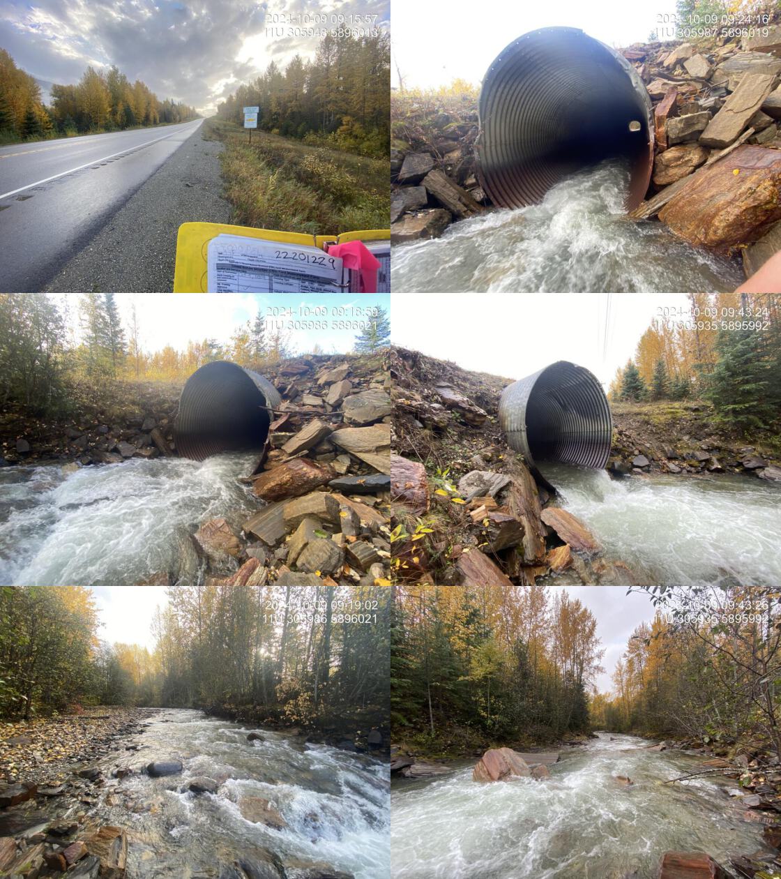
At the time of the 2024 assessment, PSCIS crossing 199282 on Highway 16 was un-embedded, non-backwatered and ranked as barrier to upstream fish passage according to the provincial protocol (MoE 2011) (Table 5.56). The culvert had a significant 0.8m outlet drop and was undersized for the stream.
The water temperature was 3\(^\circ\)C, pH was 7.5 and conductivity was 162 uS/cm.
# fpr::fpr_table_cv_summary_memo()

# See issue https://github.com/NewGraphEnvironment/mybookdown-template/issues/65
fpr::fpr_table_cv_summary_memo()| Location and Stream Data |
|
Crossing Characteristics | – |
|---|---|---|---|
| Date | 2024-10-09 | Crossing Sub Type | Round Culvert |
| PSCIS ID | 199282 | Diameter (m) | 4 |
| External ID | – | Length (m) | 52 |
| Crew | LS | Embedded | No |
| UTM Zone | 11 | Depth Embedded (m) | – |
| Easting | 305946 | Resemble Channel | No |
| Northing | 5896010 | Backwatered | No |
| Stream | Holliday Creek | Percent Backwatered | – |
| Road | Highway 16 | Fill Depth (m) | 2 |
| Road Tenure | MOTI | Outlet Drop (m) | 0.8 |
| Channel Width (m) | 16 | Outlet Pool Depth (m) | 0.5 |
| Stream Slope (%) | 3 | Inlet Drop | No |
| Beaver Activity | No | Slope (%) | 2 |
| Habitat Value | High | Valley Fill | Deep Fill |
| Final score | 37 | Barrier Result | Barrier |
| Fix type | Replace with New Open Bottom Structure | Fix Span / Diameter | 21 |
| Comments: A significant outlet drop was present. Flow was high at the time of assessment, and at lower flows, the outlet drop would be even more substantial. Although the culvert was large, it was still likely undersized for the stream. The stream was a large glaciated system with a cobble-boulder substrate and an intact mixed riparian zone, primarily deciduous. Occasional large woody debris features created deep pool habitats and pockets of gravels were present suitable for spawning salmonids. A fish (~60mm) was observed during the habitat confirmation. Chinook and bull trout have been previously captured both upstream and downstream of the crossing by Triton Environmental Consultants Ltd. MoTi chris_hwy_structure_road_id: 29925 | |||
| Photos: From top left clockwise: Road/Site Card, Barrel, Outlet, Downstream, Upstream, Inlet. | |||
|
Stream Characteristics Downstream of Crossing 199282
The stream was surveyed downstream from crossing 199282 for 350m (Figure 5.51). The habitat was rated as high value with frequent gravels suitable for spawning and occasional pools available for overwintering. Total cover amount was rated as abundant with large woody debris dominant. Cover was also present as boulders and undercut banks.The dominant substrate was cobbles with boulders sub-dominant.The average channel width was 16m, the average wetted width was 9.3m, and the average gradient was 2.8%.
Stream Characteristics Upstream of Crossing 199282
The stream was surveyed upstream from crossing 199282 for 800m (Figure 5.52). The habitat was rated as medium value for spawning and rearing. Occasional large woody debris features created deep pools, with pockets of gravels suitable for spawning. The average channel width was 11.8m, the average wetted width was 8.9m, and the average gradient was 2.5%.Total cover amount was rated as moderate with boulders dominant. Cover was also present as .The dominant substrate was cobbles with boulders sub-dominant.
Structure Remediation and Cost Estimate
Should restoration/maintenance activities proceed, replacement of the Highway 16 crossing (PSCIS 199282) with a bridge (21 m span) is recommended. At the time of reporting in 2025, the cost of the work is estimated at $ 15,750,000.
Conclusion
Holliday Creek is a large, glaciated tributary to the Fraser River. Chinook and bull trout were captured both upstream and downstream of the PSCIS crossing 199282 in 2004, indicating this stream has provided valuable fish habitat (Manson 2005). Habitat modeling from bcfishpass identified 9km of potential bull trout spawning habitat upstream of the crossing, with no other barriers identified upstream of Highway 16. Given the documented species presence and available habitat upstream, fish sampling is recommended to assess whether the outlet drop is impeding fish passage. With the Holliday Creek Arch Protected Area and trails located upstream, crossing replacement could gain momentum as part of broader conservation and recreational initiatives.
tab_hab_summary |>
  dplyr::filter(Site %in% c(my_site)) |>
  fpr::fpr_kable(caption_text = paste0("Summary of habitat details for PSCIS crossing ", my_site, "."),
scroll = F) | Site | Location | Length Surveyed (m) | Average Channel Width (m) | Average Wetted Width (m) | Average Pool Depth (m) | Average Gradient (%) | Total Cover | Habitat Value |
|---|---|---|---|---|---|---|---|---|
| 199282 | Downstream | 350 | 16.0 | 9.3 | 0.4 | 2.8 | abundant | high |
| 199282 | Upstream | 800 | 11.8 | 8.9 | 0.8 | 2.5 | moderate | medium |
my_photo1 = fpr::fpr_photo_pull_by_str(str_to_pull = 'ds_logjam')

my_caption1 = paste0('Typical habitat downstream of PSCIS crossing ', my_site, '.')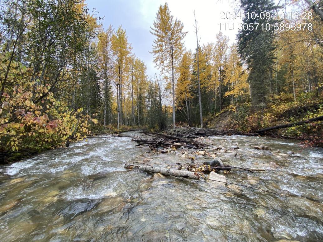
Figure 5.51: Typical habitat downstream of PSCIS crossing 199282.
my_photo2 = fpr::fpr_photo_pull_by_str(str_to_pull = 'us_typical_2_')

my_caption2 = paste0('Typical habitat upstream of PSCIS crossing ', my_site, '.')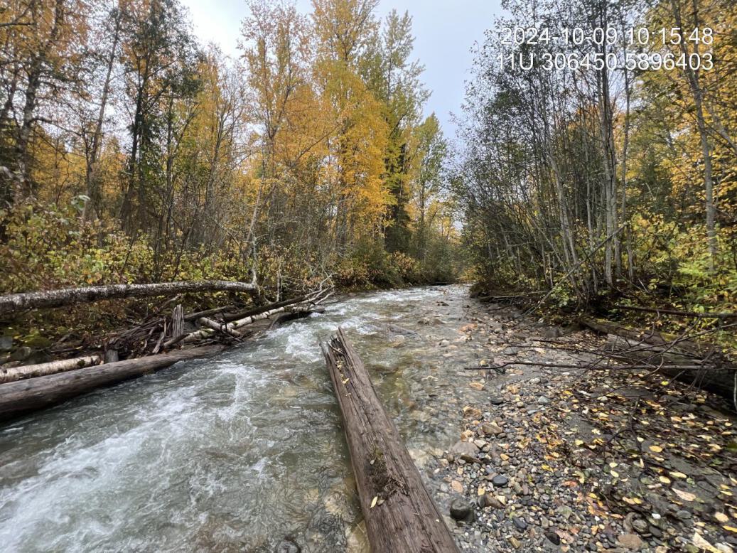
Figure 5.52: Typical habitat upstream of PSCIS crossing 199282.