Tributary To Kenneth Creek - 199255 - Appendix
Site Location
PSCIS crossing 199255 is located on a Tributary To Kenneth Creek, approximately 65km east of Prince George, BC, in the Morkill River watershed group (Figure 5.32). The crossing is located 3.7km upstream of the tributary’s confluence with Kenneth Creek, which subsequently flows into the Fraser River approximately 9km downstream. The crossing is situated on Bowron FSR, which is under the jurisdiction of the Ministry of Forests.
 my_caption <- "Map of Tributary to Kenneth Creek"

 knitr::include_graphics("fig/gis/map_trib_kenneth.jpeg")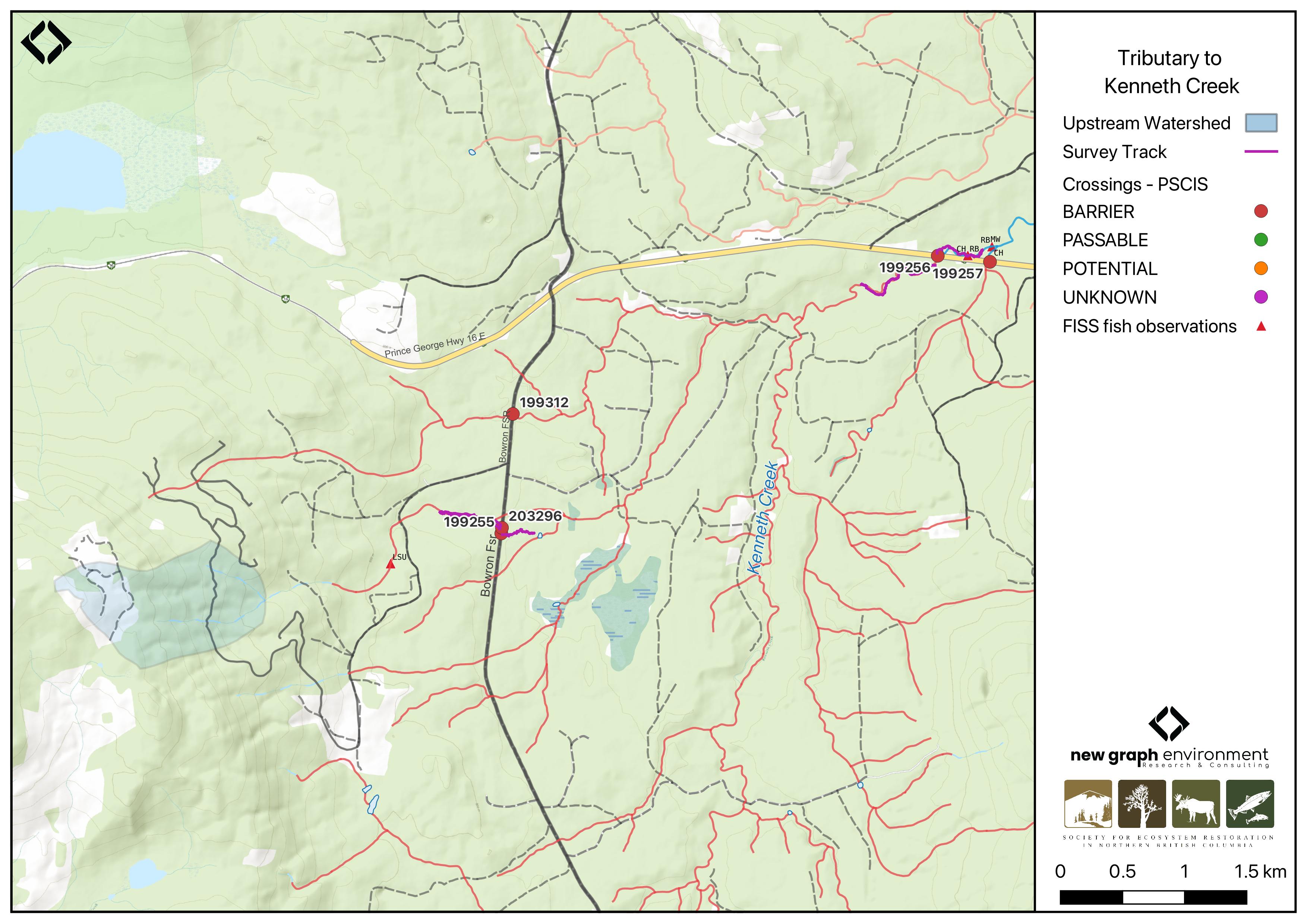
Figure 5.32: Map of Tributary to Kenneth Creek
Background
At PSCIS crossing 199255, Tributary To Kenneth Creek is a second order stream and drains a watershed of approximately 1.1km2. The watershed ranges in elevation from a maximum of 1343m to 723m near the crossing (Table 5.33). Detailed background information regarding the Kenneth Creek watershed is presented in Kenneth Creek - 199256 - Appendix.
In 2023, crossing 199255 on Bowron FSR was assessed with a fish passage assessment and prioritized for follow-up due to the presence of high-value habitat and its proximity to Kenneth Creek, which has chinook observations documented in the FISS database (MoE 2024). A habitat confirmation assessment was subsequently conducted in 2024. Upstream of Bowron FSR, longnose sucker have previously been recorded (Norris [2018] 2024; MoE 2024).
A summary of habitat modelling outputs for the crossing are presented in Table
5.34.
fpr::fpr_table_wshd_sum(site_id = my_site) |>
  fpr::fpr_kable(caption_text = paste0('Summary of derived upstream watershed statistics for PSCIS crossing ', my_site, '.'),
           footnote_text = 'Elev P60 = Elevation at which 60% of the watershed area is above',
scroll = F)| Site | Area Km | Elev Site | Elev Min | Elev Max | Elev Median | Elev P60 | Aspect |
|---|---|---|---|---|---|---|---|
| 199255 | 1.1 | 723 | 957 | 1343 | 1181 | 1127 | E |
| * Elev P60 = Elevation at which 60% of the watershed area is above |
| Habitat | Potential | Remediation Gain | Remediation Gain (%) |
|---|---|---|---|
| CH Spawning (km) | 0.0 | 0.0 | – |
| CH Rearing (km) | 0.8 | 0.8 | 100 |
| CO Spawning (km) | 0.0 | 0.0 | – |
| CO Rearing (km) | 0.0 | 0.0 | – |
| CO Rearing (ha) | 0.0 | 0.0 | – |
| SK Spawning (km) | 0.0 | 0.0 | – |
| SK Rearing (km) | 0.0 | 0.0 | – |
| SK Rearing (ha) | 0.0 | 0.0 | – |
| BT Rearing (km) | 1.6 | 0.8 | 50 |
| BT Spawning (km) | 0.8 | 0.8 | 100 |
| * Model data is preliminary and subject to adjustments. |
Stream Characteristics at Crossing 199255
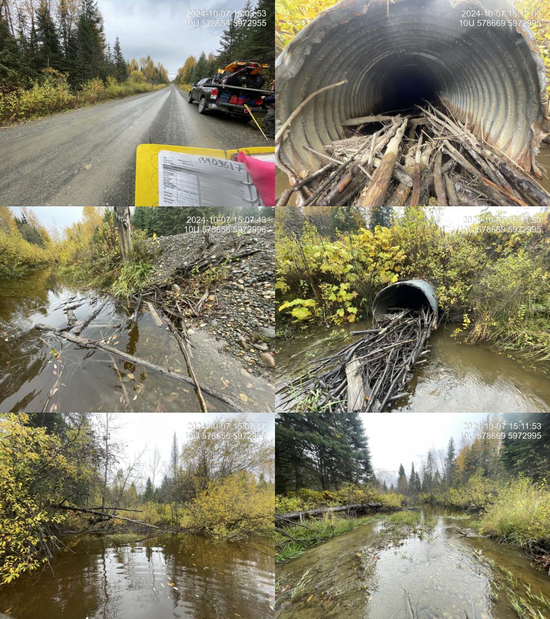
At the time of the 2024 assessment, PSCIS crossing 199255 on Bowron FSR was un-embedded, non-backwatered and ranked as barrier to upstream fish passage according to the provincial protocol (MoE 2011) (Table 5.35). The outlet of the culvert was plugged with beaver sticks, and it appeared the beaver had dammed the culvert entirely, creating a large pond area upstream of the inlet with the inlet completely submerged. Despite this, the culvert still had flow. A new culvert had been installed 60m north on the FSR (PSCIS 203296), with flow from that crossing entering the outlet pool from the north.
The water temperature was 7\(^\circ\)C, pH was 7.4 and conductivity was 80 uS/cm.
# fpr::fpr_table_cv_summary_memo()

# See issue https://github.com/NewGraphEnvironment/mybookdown-template/issues/65
fpr::fpr_table_cv_summary_memo()| Location and Stream Data |
|
Crossing Characteristics | – |
|---|---|---|---|
| Date | 2024-10-07 | Crossing Sub Type | Round Culvert |
| PSCIS ID | 199255 | Diameter (m) | 1.1 |
| External ID | – | Length (m) | 13 |
| Crew | LS | Embedded | No |
| UTM Zone | 10 | Depth Embedded (m) | – |
| Easting | 578664 | Resemble Channel | No |
| Northing | 5972996 | Backwatered | No |
| Stream | Tributary To Kenneth Creek | Percent Backwatered | – |
| Road | Bowron FSR | Fill Depth (m) | 1.5 |
| Road Tenure | MoF | Outlet Drop (m) | 0 |
| Channel Width (m) | 10.5 | Outlet Pool Depth (m) | 0.25 |
| Stream Slope (%) | 0.5 | Inlet Drop | No |
| Beaver Activity | Yes | Slope (%) | 1.5 |
| Habitat Value | Medium | Valley Fill | Deep Fill |
| Final score | 21 | Barrier Result | Barrier |
| Fix type | Replace with New Open Bottom Structure | Fix Span / Diameter | 15 |
| Comments: The inlet of the culvert was completely submerged, with a large beaver pond area just upstream. The outlet was plugged with beaver sticks, and it appeared the beaver had dammed the culvert entirely, creating a large pool at the inlet. Despite this, the culvert still had flow. A beaver dam approximately 0.7m in height was located about 40m downstream. A new culvert had been installed 60m north on the FSR, with flow from that crossing entering the outlet pool from the north. Downstream of the culvert, the stream flowed through the forest with minimal defined channel. Where a defined channel was present, it ranged from 1-3m wide, but most of the area consisted of 15-17m of wetted forest with some flow. Culvert slope was estimated due to the submerged inlet. Habitat confirmations were conducted upstream and downstream. | |||
| Photos: From top left clockwise: Road/Site Card, Barrel, Outlet, Downstream, Upstream, Inlet. | |||
|
Stream Characteristics Downstream of Crossing 199255
The stream was surveyed downstream from crossing 199255 for 270m (Figure 5.33). The habitat was rated as low value for spawning and rearing with no gravels or cobbles observed and the substrate consisting entirely of fine mud. Fish habitat was limited, with very few pools present. The first 130m of the stream was a beaver-affected area, with a beaver dam approximately 0.7m high located ~40m downstream of the culvert. The dam had flooded the surrounding forest, with no main channel observed. Occasional sections had a somewhat defined channel, but the majority of the surveyed area consisted of water flowing through a wet forest. The average channel width was 10.3m, the average wetted width was 7m, and the average gradient was 0.8%.The dominant substrate was fines with fines sub-dominant.Total cover amount was rated as moderate with overhanging vegetation dominant. Cover was also present as small woody debris, undercut banks, and instream vegetation..
Stream Characteristics Upstream of Crossing 199255
The stream was surveyed upstream from crossing 199255 for 650m (Figure 5.34). The habitat was rated as medium value with good flow and abundant gravels suitable for bull trout and cutthroat trout spawning. Occasional shallow pools provided habitat for juvenile salmonid rearing. Banks were stable, with an intact mixed mature forest. The stream was small and had some short sections with gradients up to 5% but was primarily a low-gradient riffle-gravel system. Total cover amount was rated as moderate with undercut banks dominant. Cover was also present as small woody debris, large woody debris, and overhanging vegetation.The dominant substrate was gravels with cobbles sub-dominant.The average channel width was 3.4m, the average wetted width was 2.8m, and the average gradient was 2.8%.
Structure Remediation and Cost Estimate
Should restoration/maintenance activities proceed, replacement of the Bowron FSR crossing (199255) with a bridge (15 m span) is recommended. At the time of reporting in 2025, the cost of the work is estimated at $ 450,000.
Conclusion
Although the culvert ranked as a barrier to upstream fish passage according to the provincial protocol (MoE 2011), blockage due to beaver activity is a greater issue than the culvert itself. The outlet was plugged with beaver sticks, and it appeared the beaver had dammed the culvert entirely, creating a large pond upstream with the inlet completely submerged. Despite this, some flow remained. The habitat surveyed downstream was low value but could change if beaver activity decreased; however, most of the area consisted of water flowing through a wet forest with a substrate of fine mud. Upstream habitat was rated as medium value, with good flow and abundant gravels suitable for bull trout and cutthroat trout spawning, making the crossing a moderate priority for replacement.
tab_hab_summary |>
  dplyr::filter(Site %in% c(my_site)) |>
  fpr::fpr_kable(caption_text = paste0("Summary of habitat details for PSCIS crossing ", my_site, "."),
scroll = F) | Site | Location | Length Surveyed (m) | Average Channel Width (m) | Average Wetted Width (m) | Average Pool Depth (m) | Average Gradient (%) | Total Cover | Habitat Value |
|---|---|---|---|---|---|---|---|---|
| 199255 | Downstream | 270 | 10.3 | 7.0 | 0.2 | 0.8 | moderate | low |
| 199255 | Upstream | 650 | 3.4 | 2.8 | 0.3 | 2.8 | moderate | medium |
my_photo1 = fpr::fpr_photo_pull_by_str(str_to_pull = 'ds_typical_1_')

my_caption1 = paste0('Typical habitat downstream of PSCIS crossing ', my_site, '.')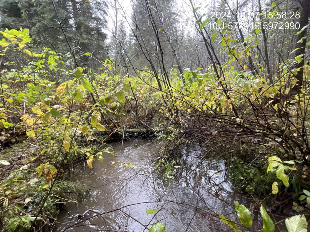
Figure 5.33: Typical habitat downstream of PSCIS crossing 199255.
my_photo2 = fpr::fpr_photo_pull_by_str(str_to_pull = 'us_typical_1_')

my_caption2 = paste0('Typical habitat upstream of PSCIS crossing ', my_site, '.')
Figure 5.34: Typical habitat upstream of PSCIS crossing 199255.
my_caption <- paste0('Left: ', my_caption1, ' Right: ', my_caption2)

knitr::include_graphics(my_photo1)
knitr::include_graphics("fig/pixel.png")
knitr::include_graphics(my_photo2)