Snowshoe Creek - 199237 - Appendix
Site Location
PSCIS crossing 199237 is located on Snowshoe Creek, approximately 45km northwest of McBride, BC, in the Morkill River watershed group. (Figure 5.29). The crossing is located 14.3km upstream of where Snowshoe Creek joins the Fraser River. The crossing is situated on Highway 16 and is the responsibility of the Ministry of Transportation and Infrastructure (chris_hwy_structure_road_id: 3751).
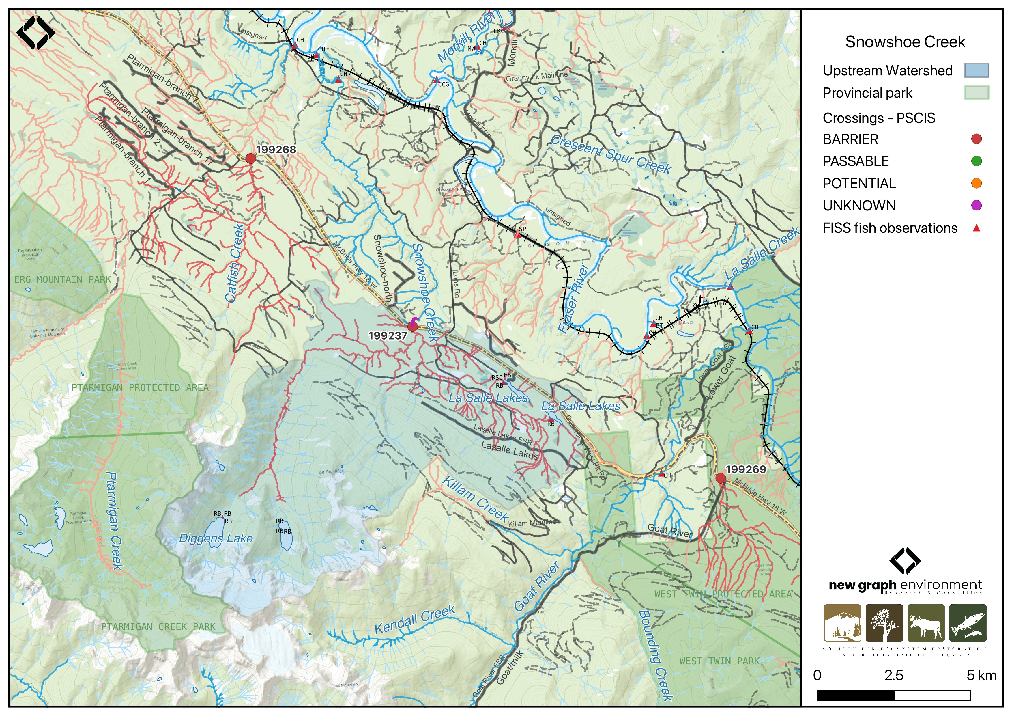
Figure 5.29: Map of Snowshoe Creek
Background
At PSCIS crossing 199237, Snowshoe Creek is a fifth order stream and drains a high elevation watershed of approximately 76.7km2. The watershed ranges in elevation from a maximum of 2491m to 829m near the crossing (Table 5.29).
In 2023, crossing 199237 on Highway 16 was assessed with a fish passage assessment and was prioritized for follow-up due to the presence of high-value habitat and historical salmon observations documented downstream in the FISS database (MoE 2024). A habitat confirmation assessment was subsequently conducted in 2024.
Upstream of Highway 16, lake chub, redside shiner, rainbow trout, steelhead, and brook trout have previously been recorded (Norris [2018] 2024; MoE 2024). Additionally, there is Fisheries and Oceans Canada stock assessment data available for Snowshoe Creek (1986 - 2003) presented in Table 2.1 of the background section (Fisheries and Oceans Canada n.d.).
A summary of habitat modelling outputs for the crossing are presented in Table 5.30.
fpr::fpr_table_wshd_sum(site_id = my_site) |>
  fpr::fpr_kable(caption_text = paste0('Summary of derived upstream watershed statistics for PSCIS crossing ', my_site, '.'),
           footnote_text = 'Elev P60 = Elevation at which 60% of the watershed area is above',
scroll = F)| Site | Area Km | Elev Site | Elev Min | Elev Max | Elev Median | Elev P60 | Aspect |
|---|---|---|---|---|---|---|---|
| 199237 | 76.7 | 829 | 648 | 2491 | 1268 | 1073 | SE |
| * Elev P60 = Elevation at which 60% of the watershed area is above |
| Habitat | Potential | Remediation Gain | Remediation Gain (%) |
|---|---|---|---|
| CH Spawning (km) | 12.2 | 8.0 | 66 |
| CH Rearing (km) | 22.3 | 11.6 | 52 |
| CO Spawning (km) | 0.0 | 0.0 | – |
| CO Rearing (km) | 0.0 | 0.0 | – |
| CO Rearing (ha) | 0.0 | 0.0 | – |
| SK Spawning (km) | 0.0 | 0.0 | – |
| SK Rearing (km) | 0.0 | 0.0 | – |
| SK Rearing (ha) | 0.0 | 0.0 | – |
| BT Rearing (km) | 25.2 | 13.7 | 54 |
| BT Spawning (km) | 17.7 | 10.3 | 58 |
| * Model data is preliminary and subject to adjustments. |
Stream Characteristics at Crossing 199237
At the time of the 2024 assessment, PSCIS crossing 199237 on Highway 16 was un-embedded, non-backwatered and ranked as barrier to upstream fish passage according to the provincial protocol (MoE 2011) (Table 5.31). The culvert had a significant 0.65m outlet drop. Photos from the 2024 assessment were limited due to the surveyor’s phone falling in the river; however, photos from the 2023 assessment can be found in Appendix - Phase 1 Fish Passage Assessment Data and Photos.
The water temperature was 6\(^\circ\)C, pH was 7.6 and conductivity was 138 uS/cm.
| Location and Stream Data |
|
Crossing Characteristics | – |
|---|---|---|---|
| Date | 2024-10-08 | Crossing Sub Type | Round Culvert |
| PSCIS ID | 199237 | Diameter (m) | 2.5 |
| External ID | – | Length (m) | 45 |
| Crew | LS | Embedded | No |
| UTM Zone | 10 | Depth Embedded (m) | – |
| Easting | 650786 | Resemble Channel | No |
| Northing | 5934862 | Backwatered | No |
| Stream | Snowshoe Creek | Percent Backwatered | – |
| Road | Highway 16 | Fill Depth (m) | 2 |
| Road Tenure | MoTi | Outlet Drop (m) | 0.65 |
| Channel Width (m) | 14 | Outlet Pool Depth (m) | 1.9 |
| Stream Slope (%) | 0.6 | Inlet Drop | No |
| Beaver Activity | No | Slope (%) | 2 |
| Habitat Value | High | Valley Fill | Deep Fill |
| Final score | 37 | Barrier Result | Barrier |
| Fix type | Replace with New Open Bottom Structure | Fix Span / Diameter | 19 |
| Comments: The culvert had a deep outlet pool and a very large outlet drop. The stream contained functional large woody debris creating complex cover and pools.No photos are available because the surveyors phone fell into the stream. Fill depth estimated. MoTi chris_hwy_structure_road_id: 3751 | |||
| Photos: From top left clockwise: Road/Site Card, Barrel, Outlet, Downstream, Upstream, Inlet. | |||
|
Stream Characteristics Downstream of Crossing 199237
The stream was surveyed downstream from crossing 199237 for 300m . The habitat was rated as high value. The average channel width was 14m, the average wetted width was 12.4m, and the average gradient was 0.7%.Total cover amount was rated as moderate with large woody debris dominant. Cover was also present as small woody debris and overhanging vegetation.The dominant substrate was fines with gravels sub-dominant. No photos were available due to the surveyor’s phone falling in the river.
Stream Characteristics Upstream of Crossing 199237
The stream was surveyed upstream from crossing 199237 for 750m , following the west fork at the junction (Figure 5.30). The habitat was rated as high value. The dominant substrate was gravels with fines sub-dominant.Total cover amount was rated as moderate with large woody debris dominant. Cover was also present as small woody debris, undercut banks, deep pools, and overhanging vegetation.The average channel width was 12.3m, the average wetted width was 11.6m, and the average gradient was 0.7%.
The east fork of Snowshoe Creek was surveyed upstream for 230m (Figure 5.31). The habitat was rated as high value. The dominant substrate was gravels with fines sub-dominant.The average channel width was 6.8m, the average wetted width was 5.5m, and the average gradient was 1.3%.Total cover amount was rated as moderate with large woody debris dominant. Cover was also present as small woody debris, undercut banks, deep pools, overhanging vegetation, and instream vegetation.
Structure Remediation and Cost Estimate
Should restoration/maintenance activities proceed, replacement of the Highway 16 crossing with a bridge (19 m span) is recommended. At the time of reporting in 2025, the cost of the work is estimated at $ 14,250,000.
Conclusion
PSCIS crossing 199237 on Highway 16 had a significant outlet drop and is a moderate priority for replacement. Although the latest data on record appears to be from 2003, according to Fisheries and Oceans Canada (n.d.), chinook have historically spawned within Snowshoe Creek, indicating this stream has provided valuable chinook spawning habitat. Given that the habitat upstream of Highway 16 was rated as high value for spawning and rearing during the 2024 assessment, replacement of the crossing is considered a high priority. In the interim, fish sampling is recommended to further assess whether the crossing is inhibiting fish passage.
tab_hab_summary |>
  dplyr::filter(Site %in% c(my_site)) |>
  fpr::fpr_kable(caption_text = paste0("Summary of habitat details for PSCIS crossing ", my_site, "."),
scroll = F) | Site | Location | Length Surveyed (m) | Average Channel Width (m) | Average Wetted Width (m) | Average Pool Depth (m) | Average Gradient (%) | Total Cover | Habitat Value |
|---|---|---|---|---|---|---|---|---|
| 199237 | Downstream | 300 | 14.0 | 12.4 | 0.6 | 0.7 | moderate | high |
| 199237 | Upstream | 750 | 12.3 | 11.6 | 0.8 | 0.7 | moderate | high |
| 199237 | us2 | 230 | 6.8 | 5.5 | 0.8 | 1.3 | moderate | high |
my_photo1 = fpr::fpr_photo_pull_by_str(str_to_pull = 'us_typical_1_')

my_caption1 = paste0('Typical habitat upstream of PSCIS crossing ', my_site, ' on the west fork on Snowshoe Creek.')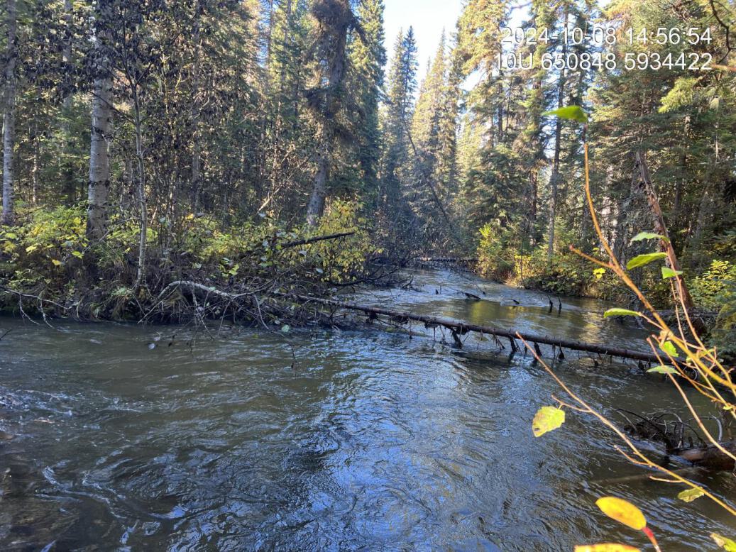
Figure 5.30: Typical habitat upstream of PSCIS crossing 199237 on the west fork on Snowshoe Creek.
my_photo2 = fpr::fpr_photo_pull_by_str(str_to_pull = 'us2_typical_2_')

my_caption2 = paste0('Typical habitat upstream of PSCIS crossing ', my_site, ' on the east fork on Snowshoe Creek.')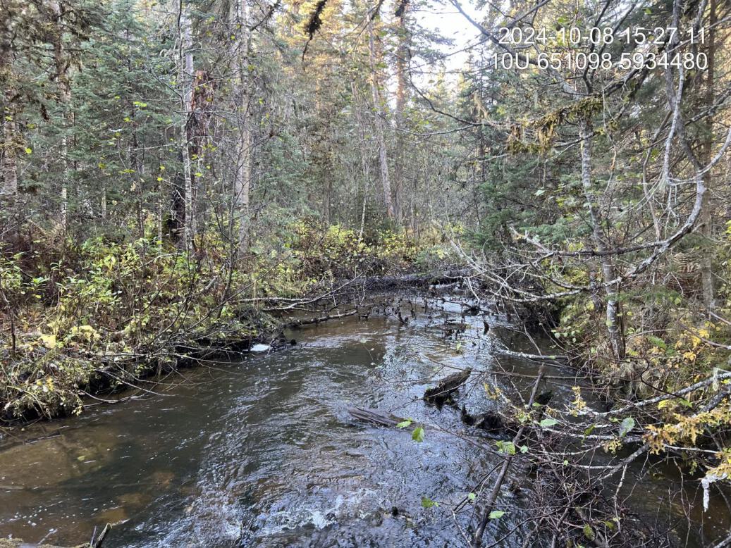
Figure 5.31: Typical habitat upstream of PSCIS crossing 199237 on the east fork on Snowshoe Creek.
my_caption <- paste0('Left: ', my_caption1, ' Right: ', my_caption2)

knitr::include_graphics(my_photo1)
knitr::include_graphics("fig/pixel.png")
knitr::include_graphics(my_photo2)