Clear Creek - 199190 - Appendix
Site Location
PSCIS crossing 199190 is located on Clear Creek, approximately 19km northwest of Vanderhoof, BC, in the Nechako River watershed group (Figure 5.19). The crossing is located 8.3km upstream of the Nechako River, on Highway 27, and is the responsibility of the Ministry of Transportation and Infrastructure (chris_culvert_id: 1806163).
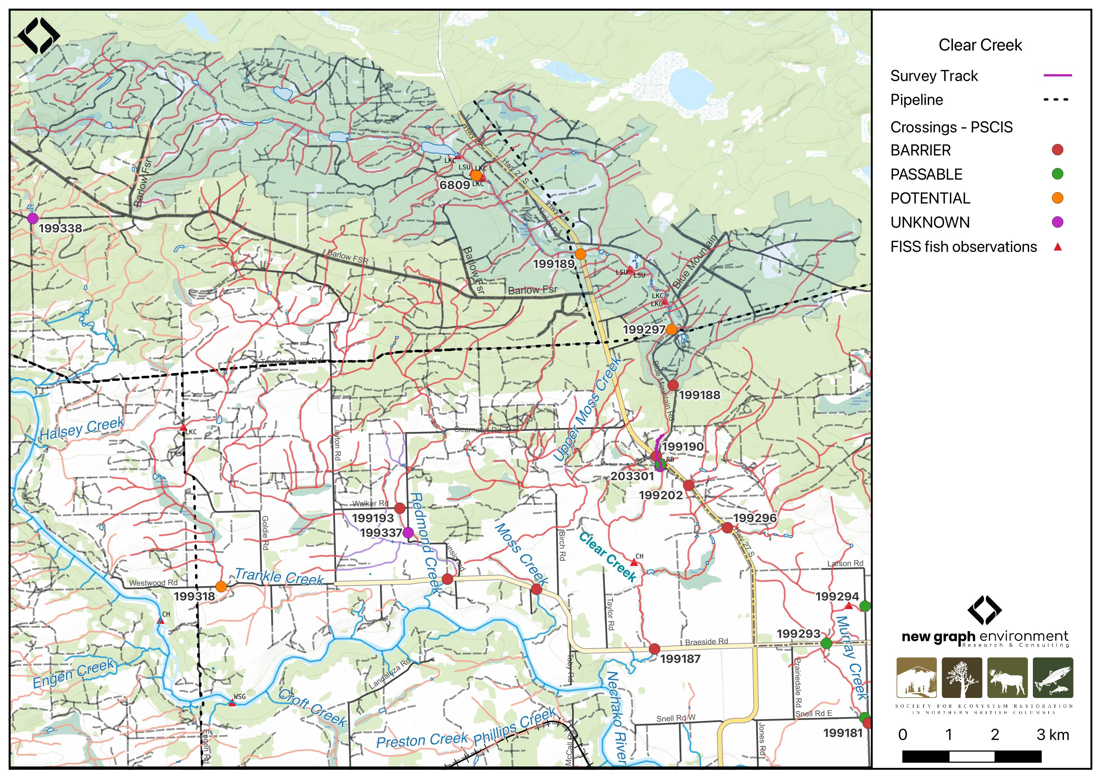
Figure 5.19: Map of Clear Creek
Background
At PSCIS crossing 199190, Clear Creek is a third order stream and drains a watershed of approximately 54.9km2. The watershed ranges in elevation from a maximum of 987m to 730m near the crossing (Table 5.17).
Since 2020, an ongoing environmental DNA (eDNA) project led by Dr. Brent Murray and Barry Booth at UNBC, in collaboration with School District (SD) 91, has been conducting fish sampling in the Nechako River watershed, including on Clear Creek. In the lower section of Clear Creek, downstream of Braeside Road, chinook salmon were repeatedly documented through sampling efforts in 2020, 2022, and 2023 (Booth 2023; B. W. Murray and Booth 2023). Upstream of PSCIS crossing 199296, located on a tributary to Clear Creek, coho salmon were detected using eDNA sampling in 2023 (B. W. Murray and Booth 2023). Further upstream on Clear Creek above crossing 199190 on Highway 27, longnose sucker and lake chub have previously been recorded (Norris [2018] 2024; MoE 2024).
Motivated by these findings, and in addition to a historical chinook salmon observation recorded downstream of Highway 27 in the FISS database (MoE 2024), several crossings within the Clear Creek system were assessed with fish passage assessments in 2023 with results found in Appendix - Phase 1 Fish Passage Assessment Data and Photos. Crossing 199187 on Braeside Road was fully backwatered and passable, as well as crossing 199296 located on a tributary to Clear Creek which joins above Braeside Road (Figure 5.19). On the mainstem of Clear Creek, crossing 199190 on Highway 27 was ranked as a barrier, noted as being in poor condition, and was prioritized for follow-up due to the presence of high-value habitat. A habitat confirmation assessment encompassing crossing 199190 was subsequently conducted in 2024.
Additionally, there is Fisheries and Oceans Canada stock assessment data available for Clear Creek presented in Table 2.1 of the background section.
A summary of habitat modelling outputs for the crossing are presented in Table 5.18.
fpr::fpr_table_wshd_sum(site_id = my_site) |>
  fpr::fpr_kable(caption_text = paste0('Summary of derived upstream watershed statistics for PSCIS crossing ', my_site, '.'),
           footnote_text = 'Elev P60 = Elevation at which 60% of the watershed area is above',
scroll = F)| Site | Area Km | Elev Site | Elev Min | Elev Max | Elev Median | Elev P60 | Aspect |
|---|---|---|---|---|---|---|---|
| 199190 | 54.9 | 730 | 660 | 987 | 859 | 848 | S |
| * Elev P60 = Elevation at which 60% of the watershed area is above |
| Habitat | Potential | Remediation Gain | Remediation Gain (%) |
|---|---|---|---|
| CH Spawning (km) | 4.4 | 3.2 | 73 |
| CH Rearing (km) | 6.2 | 3.2 | 52 |
| CO Spawning (km) | 10.2 | 3.2 | 31 |
| CO Rearing (km) | 23.8 | 3.2 | 13 |
| CO Rearing (ha) | 0.0 | 0.0 | – |
| SK Spawning (km) | 0.0 | 0.0 | – |
| SK Rearing (km) | 0.0 | 0.0 | – |
| SK Rearing (ha) | 0.0 | 0.0 | – |
| BT Rearing (km) | 28.8 | 3.5 | 12 |
| BT Spawning (km) | 10.2 | 3.2 | 31 |
| * Model data is preliminary and subject to adjustments. |
Stream Characteristics at Crossing 199190
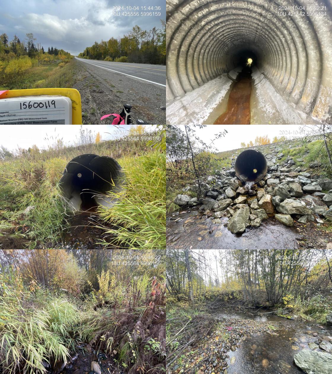
At the time of the 2024 assessment, PSCIS crossing 199190 on Highway 27 was un-embedded, non-backwatered and ranked as barrier to upstream fish passage according to the provincial protocol (MoE 2011) (Table 5.19). The culvert had a significant 1m outlet drop and had been recently worked on with new cement poured inside of the pipe and riprap placed at the outlet.
The water temperature was 5\(^\circ\)C, pH was 7.9 and conductivity was 350 uS/cm.
| Location and Stream Data |
|
Crossing Characteristics | – |
|---|---|---|---|
| Date | 2024-10-04 | Crossing Sub Type | Round Culvert |
| PSCIS ID | 199190 | Diameter (m) | 1.85 |
| External ID | – | Length (m) | 28 |
| Crew | LS | Embedded | No |
| UTM Zone | 10 | Depth Embedded (m) | – |
| Easting | 425557 | Resemble Channel | No |
| Northing | 5996165 | Backwatered | No |
| Stream | Clear Creek | Percent Backwatered | – |
| Road | Highway 27 | Fill Depth (m) | 3 |
| Road Tenure | MOTI | Outlet Drop (m) | 1 |
| Channel Width (m) | 5.22 | Outlet Pool Depth (m) | 0.2 |
| Stream Slope (%) | 1.25 | Inlet Drop | No |
| Beaver Activity | No | Slope (%) | 3 |
| Habitat Value | Medium | Valley Fill | Deep Fill |
| Final score | 39 | Barrier Result | Barrier |
| Fix type | Replace with New Open Bottom Structure | Fix Span / Diameter | 15 |
| Comments: The bottom of the culvert had been reinforced with concrete, likely to address holes noted in the previous assessment. A large pile of riprap was placed at the outlet, possibly to reduce the outlet drop, though its placement appeared unusual and could inhibit fish passage. The habitat was high quality, with a large pool just downstream of the culvert and abundant gravels suitable for spawning fish. In the lower section of Clear Creek, downstream of Braeside Road, chinook salmon have been repeatedly documented through sampling efforts part of an ongoing environmental DNA (eDNA) project led by Dr. Brent Murray and Barry Booth at UNBC. MoTi chris_culvert_id: 1806163 | |||
| Photos: From top left clockwise: Road/Site Card, Barrel, Outlet, Downstream, Upstream, Inlet. | |||
|
Stream Characteristics Downstream of Crossing 199190
The stream was surveyed downstream from crossing 199190 for 335m (Figure 5.20). The habitat was rated as high value for salmonid spawning and rearing. The stream contained frequent pools suitable for overwintering fish, with abundant cobbles but limited gravels. Evidence of extreme seasonal flows was observed, including large eroding banks, extensive gravel deposits from channel widening (20 – 30m), and significant log jams. The dominant substrate was cobbles with fines sub-dominant.Total cover amount was rated as abundant with large woody debris dominant. Cover was also present as small woody debris and undercut banks.The average channel width was 5.4m, the average wetted width was 4m, and the average gradient was 1.2%.
Stream Characteristics Upstream of Crossing 199190
The stream was surveyed upstream from crossing 199190 for 550m (Figure 5.21). The habitat was rated as low value. Although the stream had good flow and provided high-quality habitat for the first 100m, it then transitioning to subsurface flow. Approximately 200m upstream of the highway, adjacent to a quarry, the stream was fully dewatered to the top of the surveyed area. The channel was highly confined, lacked complexity, and consisted primarily of a straight, coarse cobble and boulder substrate. While some small and large woody debris were present, they did not appear to contribute to habitat formation during periods of flow. Total cover amount was rated as trace with boulders dominant. Cover was also present as overhanging vegetation.The average channel width was 5.2m, the average wetted width was 3.1m, and the average gradient was 1.3%.The dominant substrate was cobbles with boulders sub-dominant.
Structure Remediation and Cost Estimate
Should restoration/maintenance activities proceed, replacement of the Highway 27 crossing (199190) with a bridge (15 m span) is recommended. At the time of reporting in 2025, the cost of the work is estimated at $ 11,250,000.
Conclusion
The habitat upstream of PSCIS crossing 199190 on Highway 27 was documented as low value for salmonid spawning and rearing, and the crossing is rated as a low priority for replacement due to the intermittent nature of the stream approximately 200m upstream of the crossing. The culvert had been recently worked on, with new cement poured inside the pipe and riprap placed at the outlet. However, fish sampling to determine whether fish are utilizing the ~200m of wetted stream upstream of the crossing would still be beneficial.
tab_hab_summary |>
  dplyr::filter(Site %in% c(my_site)) |>
  fpr::fpr_kable(caption_text = paste0("Summary of habitat details for PSCIS crossing ", my_site, "."),
scroll = F) | Site | Location | Length Surveyed (m) | Average Channel Width (m) | Average Wetted Width (m) | Average Pool Depth (m) | Average Gradient (%) | Total Cover | Habitat Value |
|---|---|---|---|---|---|---|---|---|
| 199190 | Downstream | 335 | 5.4 | 4.0 | 0.4 | 1.2 | abundant | high |
| 199190 | Upstream | 550 | 5.2 | 3.1 | 0.3 | 1.3 | trace | low |
my_photo1 = fpr::fpr_photo_pull_by_str(str_to_pull = 'ds_typical_1_')

my_caption1 = paste0('Typical habitat downstream of PSCIS crossing ', my_site, '.')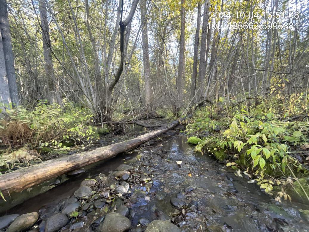
Figure 5.20: Typical habitat downstream of PSCIS crossing 199190.
my_photo2 = fpr::fpr_photo_pull_by_str(str_to_pull = 'us_dry_')

my_caption2 = paste0('The stream went subsurface approximately 200m upstream of PSCIS crossing ', my_site, '.')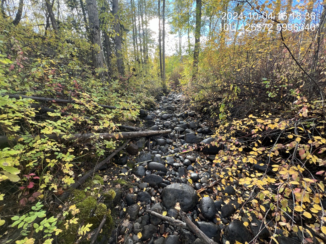
Figure 5.21: The stream went subsurface approximately 200m upstream of PSCIS crossing 199190.
my_caption <- paste0('Left: ', my_caption1, ' Right: ', my_caption2)

knitr::include_graphics(my_photo1)
knitr::include_graphics("fig/pixel.png")
knitr::include_graphics(my_photo2)