Nine Mile Creek - 199204 - Appendix
Site Location
PSCIS crossing 199204 is located on Nine Mile Creek, approximately 11km northeast of the Nadleh Whut’en First Nations community near Fraser Lake, BC, in the Nechako River watershed group (Figure 5.22). The crossing is 4.6km upstream of the confluence of Nine Mile Creek and the Nechako River. The crossing is situated on Settlement Road, which is the responsibility of the Ministry of Transportation and Infrastructure (chris_culvert_id: 1793923).
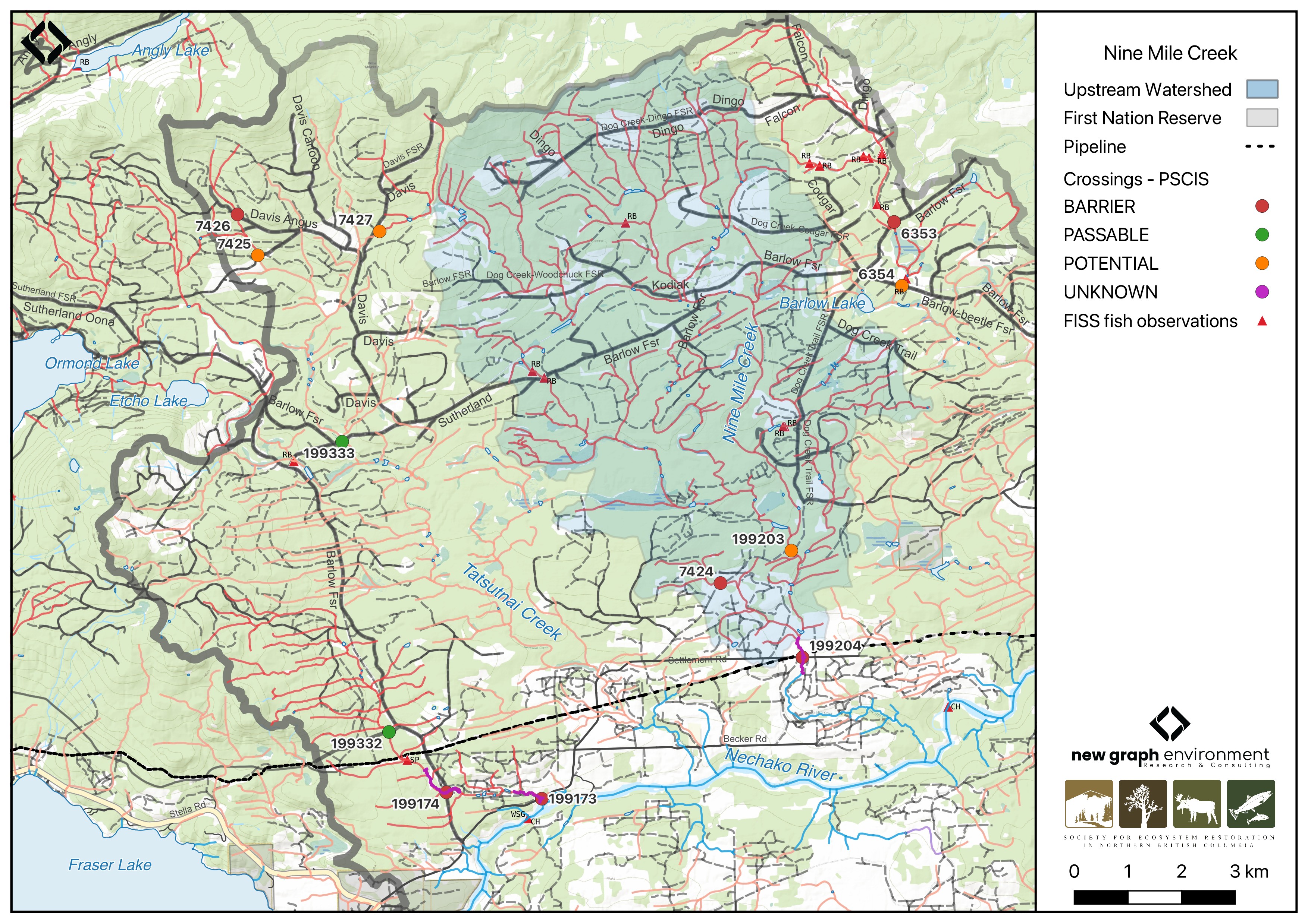
Figure 5.22: Map of Nine Mile Creek
Background
At PSCIS crossing 199204, Nine Mile Creek is a fifth order stream and drains a watershed of approximately 62.4km2. The watershed ranges in elevation from a maximum of 1317m to 754m near the crossing (Table 5.21).
Since 2020, an ongoing environmental DNA (eDNA) project led by Dr. Brent Murray and Barry Booth at UNBC, in collaboration with School District (SD) 91, has been conducting fish sampling in the Nechako River watershed, including on Nine Mile Creek. Minnow trapping by Booth (2022) in 2021 captured chinook just downstream of this crossing but not upstream, despite the presence of suitable habitat. The study suggested that these culverts may be a barrier to further upstream movement of chinook (Booth 2022). eDNA results from 2021 showed a strong detection for chinook immediately downstream of the Settlement Road crossing, while 2023 results showed a weaker detection at the same location (B. Murray and Booth 2024; B. W. Murray and Booth 2023). Additionally, a strong detection for chinook was observed near the confluence of Nine Mile Creek and the Nechako River in 2023 (B. W. Murray and Booth 2023).
Based on these findings, in 2023, crossing 199204 on Settlement Road was assessed with a fish passage assessment and prioritized for follow-up due to the presence of high-value habitat. A habitat confirmation assessment was subsequently conducted in 2024. Upstream of the Settlement Road, rainbow trout have previously been recorded (Norris [2018] 2024; MoE 2024).
A summary of habitat modelling outputs for the crossing are presented in Table 5.22.
fpr::fpr_table_wshd_sum(site_id = my_site) |>
  fpr::fpr_kable(caption_text = paste0('Summary of derived upstream watershed statistics for PSCIS crossing ', my_site, '.'),
           footnote_text = 'Elev P60 = Elevation at which 60% of the watershed area is above',
scroll = F)| Site | Area Km | Elev Site | Elev Min | Elev Max | Elev Median | Elev P60 | Aspect |
|---|---|---|---|---|---|---|---|
| 199204 | 62.4 | 754 | 715 | 1317 | 905 | 876 | S |
| * Elev P60 = Elevation at which 60% of the watershed area is above |
| Habitat | Potential | Remediation Gain | Remediation Gain (%) |
|---|---|---|---|
| CH Spawning (km) | 8.0 | 2.1 | 26 |
| CH Rearing (km) | 24.1 | 4.0 | 17 |
| CO Spawning (km) | 16.0 | 2.4 | 15 |
| CO Rearing (km) | 36.8 | 4.0 | 11 |
| CO Rearing (ha) | 0.0 | 0.0 | – |
| SK Spawning (km) | 0.0 | 0.0 | – |
| SK Rearing (km) | 0.0 | 0.0 | – |
| SK Rearing (ha) | 0.0 | 0.0 | – |
| BT Rearing (km) | 36.3 | 4.3 | 12 |
| BT Spawning (km) | 16.0 | 2.4 | 15 |
| * Model data is preliminary and subject to adjustments. |
Stream Characteristics at Crossing 199204
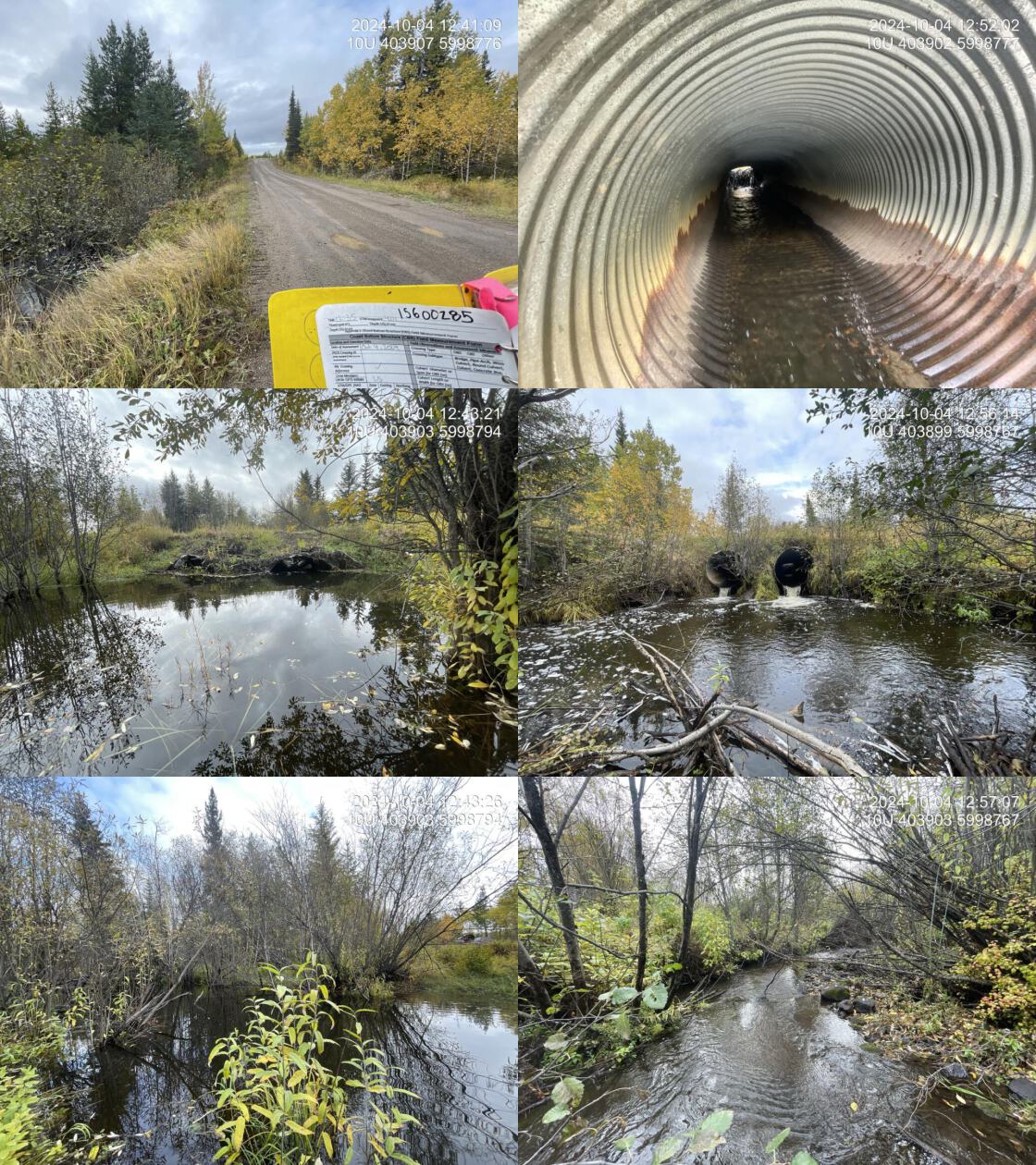
At the time of the 2024 assessment, PSCIS crossing 199204 on Settlement Road was un-embedded, non-backwatered and ranked as barrier to upstream fish passage according to the provincial protocol (MoE 2011) (Table 5.23). Two 1.6m diameter pipes were present, with both inlets dammed by a beaver, causing water to back up to nearly the full height of the culverts. The culverts had a moderate 0.5m outlet drop
The water temperature was 5\(^\circ\)C, pH was 7.9 and conductivity was 233 uS/cm.
# fpr::fpr_table_cv_summary_memo()

# See issue https://github.com/NewGraphEnvironment/mybookdown-template/issues/65
fpr::fpr_table_cv_summary_memo()| Location and Stream Data |
|
Crossing Characteristics | – |
|---|---|---|---|
| Date | 2024-10-04 | Crossing Sub Type | Round Culvert |
| PSCIS ID | 199204 | Diameter (m) | 3.2 |
| External ID | – | Length (m) | 12 |
| Crew | LS | Embedded | No |
| UTM Zone | 10 | Depth Embedded (m) | – |
| Easting | 403906 | Resemble Channel | No |
| Northing | 5998777 | Backwatered | No |
| Stream | Nine Mile Creek | Percent Backwatered | – |
| Road | Settlement Road | Fill Depth (m) | 0.5 |
| Road Tenure | MOTI | Outlet Drop (m) | 0.5 |
| Channel Width (m) | 5.5 | Outlet Pool Depth (m) | 1.4 |
| Stream Slope (%) | 0.5 | Inlet Drop | No |
| Beaver Activity | Yes | Slope (%) | 2 |
| Habitat Value | Medium | Valley Fill | Deep Fill |
| Final score | 31 | Barrier Result | Barrier |
| Fix type | Replace with New Open Bottom Structure | Fix Span / Diameter | 15 |
| Comments: The inlets of both culverts were dammed by a beaver, backing up water to most of the culverts’ height. Two pipes, each 1.6m in diameter, were present. A large outlet pool indicated the pipes were likely undersized for the stream. Another beaver dam was being constructed at the outlet of the pool. The dirt road had minimal road fill, making construction relatively straightforward. The road appeared to be used for pipeline access. Outlet pool depth was estimated as it was too deep to wade. Fish approximately 40mm in length were observed downstream during habitat confirmation. Chinook have been captured and detected just downstream of this crossing as part of an ongoing environmental DNA (eDNA) project led by Dr. Brent Murray and Barry Booth at UNBC. MoTi chris_culvert_id: 1793923 | |||
| Photos: From top left clockwise: Road/Site Card, Barrel, Outlet, Downstream, Upstream, Inlet. | |||
|
Stream Characteristics Downstream of Crossing 199204
The stream was surveyed downstream from crossing 199204 for 300m (Figure 5.23). The habitat was rated as high value, with good stream flow, frequent deep pools suitable for overwintering fish, and abundant spawning gravels. Significant beaver activity was observed, including old and active dams blocking both culverts on Settlement Road. The first 150m showed signs of cattle trampling, with numerous small trails crossing the stream. Approximately 300m downstream of Settlement Road, the stream had been artificially entrenched, creating a large backwatered pool with water pipes leading in, likely related to the adjacent cut block (Figure 5.24). Despite modifications, the stream remained well-defined, providing excellent fish habitat. The east side of the stream bordered a cut block with a 30 – 50m buffer zone. One small fish (~40mm) was observed during the survey. The average channel width was 5.5m, the average wetted width was 3.6m, and the average gradient was 0.8%.Total cover amount was rated as abundant with undercut banks dominant. Cover was also present as large woody debris and deep pools.The dominant substrate was gravels with fines sub-dominant.
Stream Characteristics Upstream of Crossing 199204
The stream was surveyed upstream from crossing 199204 for 425m (Figure 5.25). The habitat was rated as medium value for spawning and rearing. The stream was a larger system with significant beaver activity, creating impoundments behind dams ranging from 0.3 - 1.5m in height. Heavy cattle use was evident in riparian areas, with trampled banks, extensive browsing of riparian shrubs, and a significant amount of manure within seasonally inundated areas. Nutrient loading to the stream appeared high, with large amounts of algae present on the primarily gravel substrates in sections of the channel linking beaver-impounded areas. The average channel width was 6.2m, the average wetted width was 4.4m, and the average gradient was 3%.The dominant substrate was fines with gravels sub-dominant.Total cover amount was rated as moderate with deep pools dominant. Cover was also present as small woody debris, overhanging vegetation, and instream vegetation.
Structure Remediation and Cost Estimate
Should restoration/maintenance activities proceed, replacement of the Settlement Road crossing (199204) with a bridge (15 m span) is recommended. At the time of reporting in 2025, the cost of the work is estimated at $ 1,500,000.
Conclusion
Nine Mile Creek is a tributary to the Nechako River and a known chinook system, with chinook captured immediately downstream of the crossing in 2021 and detected through eDNA sampling as recently as 2023 (Booth 2022; B. W. Murray and Booth 2023). Medium value habitat was observed upstream of the crossing, with bcfishpass modeling indicating 8km of potential chinook spawning habitat and 16km of potential coho spawning habitat upstream. Downstream provided excellent fish habitat with good stream flow, frequent deep pools suitable for overwintering fish, and abundant spawning gravels. Beaver activity and heavy cattle use was observed both upstream and downstream of the crossing. The culverts had a moderate outlet drop, and the crossing is a moderate priority for replacement. Given the species present in the system and the outlet drops at both crossings, fish sampling is recommended to determine whether the culverts are impeding fish passage.
tab_hab_summary |>
  dplyr::filter(Site %in% c(my_site)) |>
  fpr::fpr_kable(caption_text = paste0("Summary of habitat details for PSCIS crossing ", my_site, "."),
scroll = F) | Site | Location | Length Surveyed (m) | Average Channel Width (m) | Average Wetted Width (m) | Average Pool Depth (m) | Average Gradient (%) | Total Cover | Habitat Value |
|---|---|---|---|---|---|---|---|---|
| 199204 | Downstream | 300 | 5.5 | 3.6 | 0.4 | 0.8 | abundant | high |
| 199204 | Upstream | 425 | 6.2 | 4.4 | 0.8 | 3.0 | moderate | medium |
my_photo1 = fpr::fpr_photo_pull_by_str(str_to_pull = 'ds_typical_2_')

my_caption1 = paste0('Typical habitat downstream of PSCIS crossing ', my_site, '.')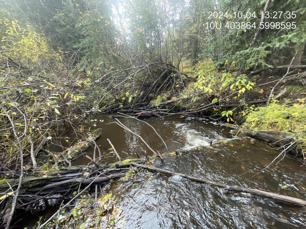
Figure 5.23: Typical habitat downstream of PSCIS crossing 199204.
my_photo2 = fpr::fpr_photo_pull_by_str(str_to_pull = 'trench')

my_caption2 = paste0('Large, artificially entrenched pool located ~300m downstream of PSCIS crossing ', my_site, '.')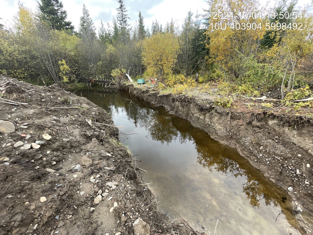
Figure 5.24: Large, artificially entrenched pool located ~300m downstream of PSCIS crossing 199204.
my_caption <- paste0('Left: ', my_caption1, ' Right: ', my_caption2)

knitr::include_graphics(my_photo1)
knitr::include_graphics("fig/pixel.png")
knitr::include_graphics(my_photo2)
my_photo1 = fpr::fpr_photo_pull_by_str(str_to_pull = 'us_typical_2_')
my_caption1 = paste0('Typical habitat upstream of PSCIS crossing ', my_site, '.')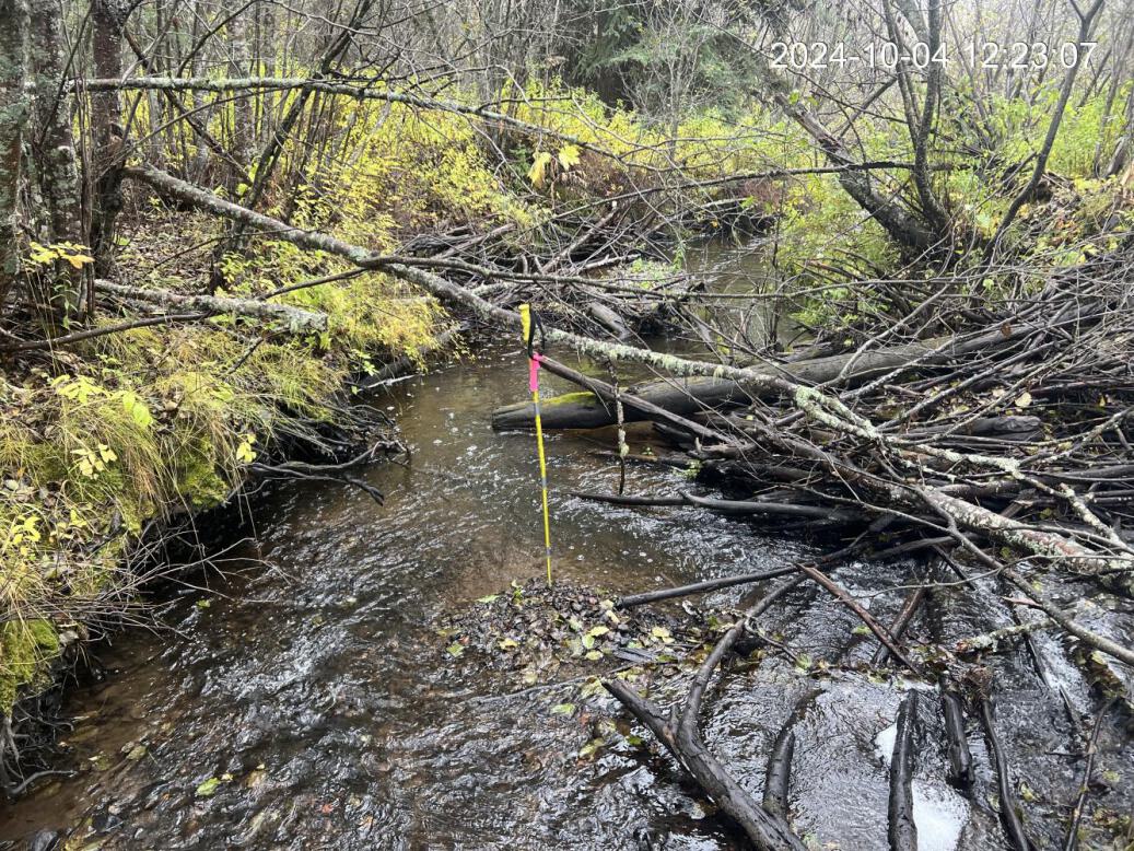
Figure 5.25: Typical habitat upstream of PSCIS crossing 199204.