Tributary To Sugarbowl Creek - 199260 - Appendix
Site Location
PSCIS crossing 199260 is located on Tributary To Sugarbowl Creek, approximately 100km east of Prince George, BC, in the Morkill River watershed group (Figure 5.40). The crossing is located 2.4km upstream of Sugarbowl Creek, which flows into Kenneth Creek before joining the Fraser River. The crossing is situated on Highway 16 and is under the jurisdiction of the Ministry of Transportation and Infrastructure (chris_culvert_id: 1992815).
This crossing is located in the Sugarbowl-Grizzly Den Provincial Park which is within the traditional territory of the Lheidli T’enneh. The park protects a significant area of old-growth interior cedar-hemlock forest, provides high-quality habitat for wildlife, including grizzly bear, marten, and caribou, and serves as an important movement corridor for caribou. Additionally, the area features a trail system that supports popular alpine backcountry recreation opportunities near Prince George (“Sugarbowl-Grizzly Den Park” n.d.; “Sugarbowl-Grizzly Den Cabins – PGBRS” n.d.).
 my_caption <- "Map of Tributary to Sugarbowl Creek"

 knitr::include_graphics("fig/gis/map_trib_sugarbowl.jpeg")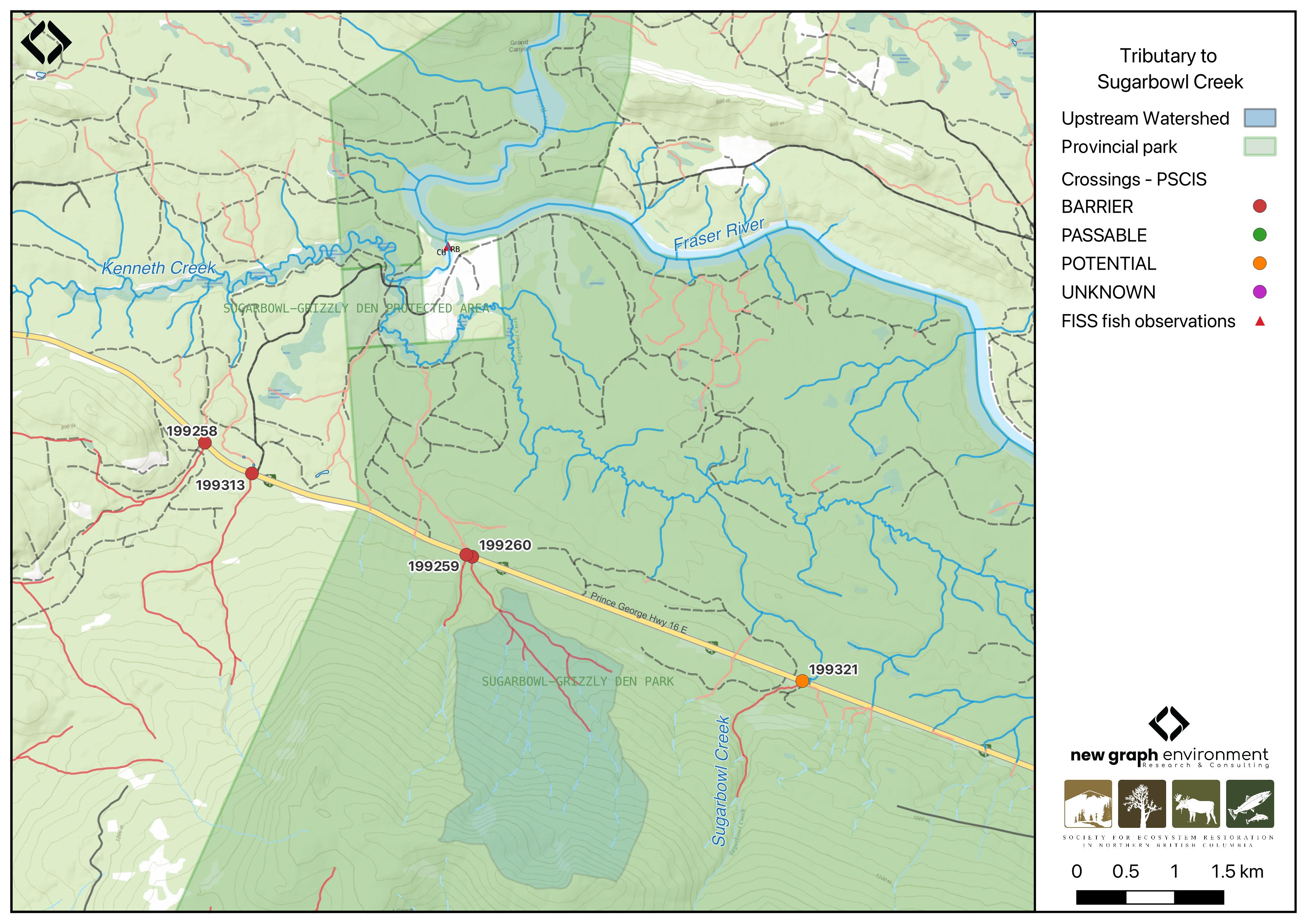
Figure 5.40: Map of Tributary to Sugarbowl Creek
Background
At the crossing location, Tributary To Sugarbowl Creek is a third order stream and drains a high elevation watershed of approximately 4.4km2. The watershed ranges in elevation from a maximum of 1801m to 776m near the crossing (Table 5.41).
In 2023, crossing 199260 on Highway 16 was assessed with a fish passage assessment and prioritized for follow-up due to the presence of high-value habitat. A habitat confirmation assessment was subsequently conducted in 2024.
Approximately 4.5km downstream of the crossing, near the confluence of Kenneth Creek and the Fraser River, chinook and bull trout have previously been recorded (Norris [2018] 2024; MoE 2024). Additionally, there is Fisheries and Oceans Canada stock assessment data available for Kenneth Creek (downstream) presented in Table 2.1 of the background section (Fisheries and Oceans Canada n.d.).
fpr::fpr_table_wshd_sum(site_id = my_site) |>
  fpr::fpr_kable(caption_text = paste0('Summary of derived upstream watershed statistics for PSCIS crossing ', my_site, '.'),
           footnote_text = 'Elev P60 = Elevation at which 60% of the watershed area is above',
scroll = F)| Site | Area Km | Elev Site | Elev Min | Elev Max | Elev Median | Elev P60 | Aspect |
|---|---|---|---|---|---|---|---|
| 199260 | 4.4 | 776 | 726 | 1801 | 1160 | 1058 | NE |
| * Elev P60 = Elevation at which 60% of the watershed area is above |
| Habitat | Potential | Remediation Gain | Remediation Gain (%) |
|---|---|---|---|
| CH Spawning (km) | 0.0 | 0.0 | – |
| CH Rearing (km) | 0.0 | 0.0 | – |
| CO Spawning (km) | 0.0 | 0.0 | – |
| CO Rearing (km) | 0.0 | 0.0 | – |
| CO Rearing (ha) | 0.0 | 0.0 | – |
| SK Spawning (km) | 0.0 | 0.0 | – |
| SK Rearing (km) | 0.0 | 0.0 | – |
| SK Rearing (ha) | 0.0 | 0.0 | – |
| BT Rearing (km) | 0.9 | 0.9 | 100 |
| BT Spawning (km) | 0.0 | 0.0 | – |
| * Model data is preliminary and subject to adjustments. |
Stream Characteristics at Crossing 199260
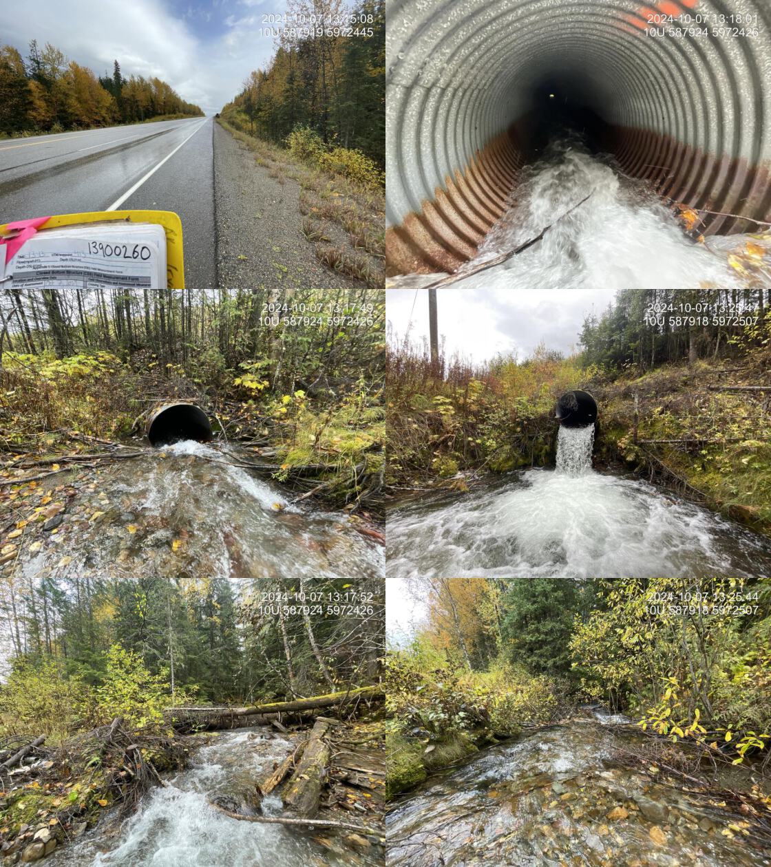
At the time of the 2024 assessment, PSCIS crossing 199260 on Highway 16 was un-embedded, non-backwatered and ranked as barrier to upstream fish passage according to the provincial protocol (MoE 2011) (Table 5.43). The culvert had a significant 1.4m outlet drop.
The water temperature was 5\(^\circ\)C, pH was 7.8 and conductivity was 208 uS/cm.
| Location and Stream Data |
|
Crossing Characteristics | – |
|---|---|---|---|
| Date | 2024-10-07 | Crossing Sub Type | Round Culvert |
| PSCIS ID | 199260 | Diameter (m) | 1.2 |
| External ID | – | Length (m) | 50 |
| Crew | LS | Embedded | No |
| UTM Zone | 10 | Depth Embedded (m) | – |
| Easting | 587916 | Resemble Channel | No |
| Northing | 5972449 | Backwatered | No |
| Stream | Tributary To Sugarbowl Creek | Percent Backwatered | – |
| Road | Highway 16 | Fill Depth (m) | 9 |
| Road Tenure | MOTI | Outlet Drop (m) | 1.4 |
| Channel Width (m) | 7 | Outlet Pool Depth (m) | 0.9 |
| Stream Slope (%) | 5 | Inlet Drop | Yes |
| Beaver Activity | No | Slope (%) | 6 |
| Habitat Value | High | Valley Fill | Deep Fill |
| Final score | 42 | Barrier Result | Barrier |
| Fix type | Replace with New Open Bottom Structure | Fix Span / Diameter | 33 |
| Comments: The culvert had a significant 1.4m outlet drop, and inlet drop due to a small debris jam. The stream flowed through mature old-growth forest and provided high-quality habitat with steep gradients, step pools, and cascade pools, suggesting the potential presence of bull trout. The highway crossing had a large amount of road fill, making construction difficult and expensive. The site would be a good candidate for replacement if feasible. The riparian area at the outlet had been cleared due to overhead powerlines. MoTi chris_culvert_id: 1992815 | |||
| Photos: From top left clockwise: Road/Site Card, Barrel, Outlet, Downstream, Upstream, Inlet. | |||
|
Stream Characteristics Downstream of Crossing 199260
The stream was surveyed downstream from crossing 199260 for 320m (Figure 5.41). The habitat was rated as high value, with gravels suitable for spawning and occasional pools ranging from 0.2 – 0.4m deep providing overwintering habitat. The stream flowed through a healthy, mature old-growth forest. Total cover amount was rated as abundant with large woody debris dominant. Cover was also present as small woody debris and boulders.The dominant substrate was cobbles with boulders sub-dominant.The average channel width was 7m, the average wetted width was 4.2m, and the average gradient was 5.3%.
Stream Characteristics Upstream of Crossing 199260
The stream was surveyed upstream from crossing 199260 for 650m (Figure 5.42). The habitat was rated as medium value, and appeared suitable for large bull trout spawning and rearing. The stream was a larger, steeper system with intact, mature coniferous cedar-hemlock riparian cover, primarily stable banks, and abundant large woody debris throughout. A step-pool morphology was present, characterized by pools up to 80cm deep and debris jam steps ranging from 30 – 60cm. The average channel width was 6.1m, the average wetted width was 5.1m, and the average gradient was 7.1%.Total cover amount was rated as moderate with large woody debris dominant. Cover was also present as small woody debris, boulders, undercut banks, deep pools, and overhanging vegetation.The dominant substrate was cobbles with gravels sub-dominant.
Structure Remediation and Cost Estimate
Should restoration/maintenance activities proceed, replacement of the Highway 16 crossing (199260) with a bridge (33 m span) is recommended. At the time of reporting in 2025, the cost of the work is estimated at $ 24,750,000.
Conclusion
PSCIS crossing 199260 had a substantial outlet drop and is a high priority for replacement. Average gradients were generally above the maximum thresholds for chinook spawning and rearing (4.5% and 5.5%, respectively), but fell within the suitable range for bull trout spawning and rearing (5.5% and 10.5%, respectively). The habitat upstream was rated as medium value for bull trout spawning and rearing, with bcfishpass modeling indicating ~900m of potential bull trout rearing habitat upstream of the crossing. Given the crossings location within Sugarbowl-Grizzly Den Provincial Park and the park’s ecological significance, restoration efforts could align with broader conservation initiatives and public engagement, increasing the likelihood of funding and project momentum.
tab_hab_summary |>
  dplyr::filter(Site %in% c(my_site)) |>
  fpr::fpr_kable(caption_text = paste0("Summary of habitat details for PSCIS crossing ", my_site, "."),
scroll = F) | Site | Location | Length Surveyed (m) | Average Channel Width (m) | Average Wetted Width (m) | Average Pool Depth (m) | Average Gradient (%) | Total Cover | Habitat Value |
|---|---|---|---|---|---|---|---|---|
| 199260 | Downstream | 320 | 7.0 | 4.2 | 0.3 | 5.3 | abundant | high |
| 199260 | Upstream | 650 | 6.1 | 5.1 | 0.4 | 7.1 | moderate | medium |
my_photo1 = fpr::fpr_photo_pull_by_str(str_to_pull = 'ds_typical_1_')

my_caption1 = paste0('Typical habitat downstream of PSCIS crossing ', my_site, '.')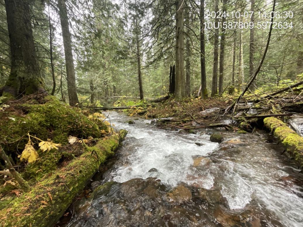
Figure 5.41: Typical habitat downstream of PSCIS crossing 199260.
my_photo2 = fpr::fpr_photo_pull_by_str(str_to_pull = 'us_typical_1_')

my_caption2 = paste0('Typical habitat upstream of PSCIS crossing ', my_site, '.')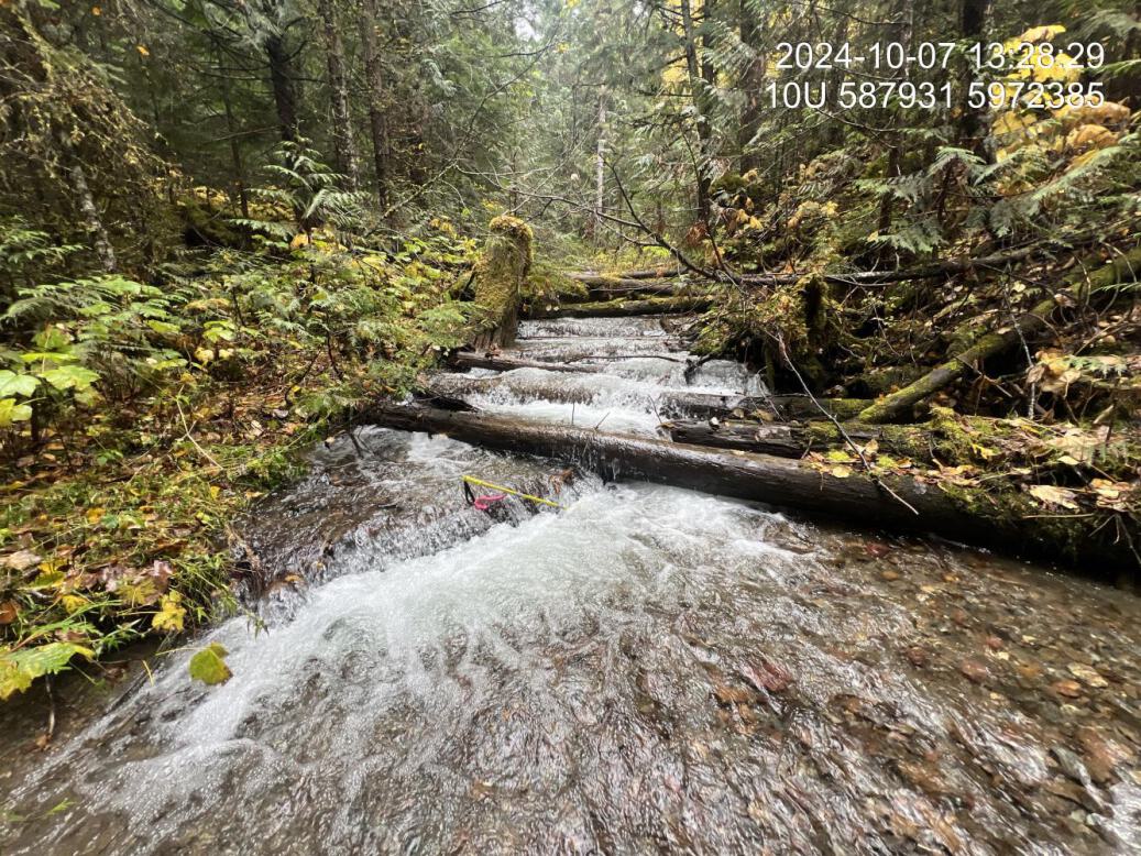
Figure 5.42: Typical habitat upstream of PSCIS crossing 199260.
my_caption <- paste0('Left: ', my_caption1, ' Right: ', my_caption2)

knitr::include_graphics(my_photo1)
knitr::include_graphics("fig/pixel.png")
knitr::include_graphics(my_photo2)