Kenneth Creek - 199256 - Appendix
Site Location
PSCIS crossing 199256 is located on Kenneth Creek, approximately 80km east of Prince George, BC, in the Morkill River watershed group (Figure 5.35). The crossing is located 9.8km upstream of the confluence of Kenneth Creek and the Fraser River. The crossing is situated on Highway 16, and is the responsibility of the Ministry of Transportation and Infrastructure (chris_hwy_structure_road_id: 3750).
The headwaters and confluence of Kenneth Creek overlap the Sugarbowl-Grizzly Den Provincial Park which is within the traditional territory of the Lheidli T’enneh (Figure 5.35). The park protects a significant area of old-growth interior cedar-hemlock forest, provides high-quality habitat for wildlife, including grizzly bear, marten, and caribou, and serves as an important movement corridor for caribou. Additionally, the area features a trail system that supports popular alpine backcountry recreation opportunities near Prince George (“Sugarbowl-Grizzly Den Park” n.d.; “Sugarbowl-Grizzly Den Cabins – PGBRS” n.d.).
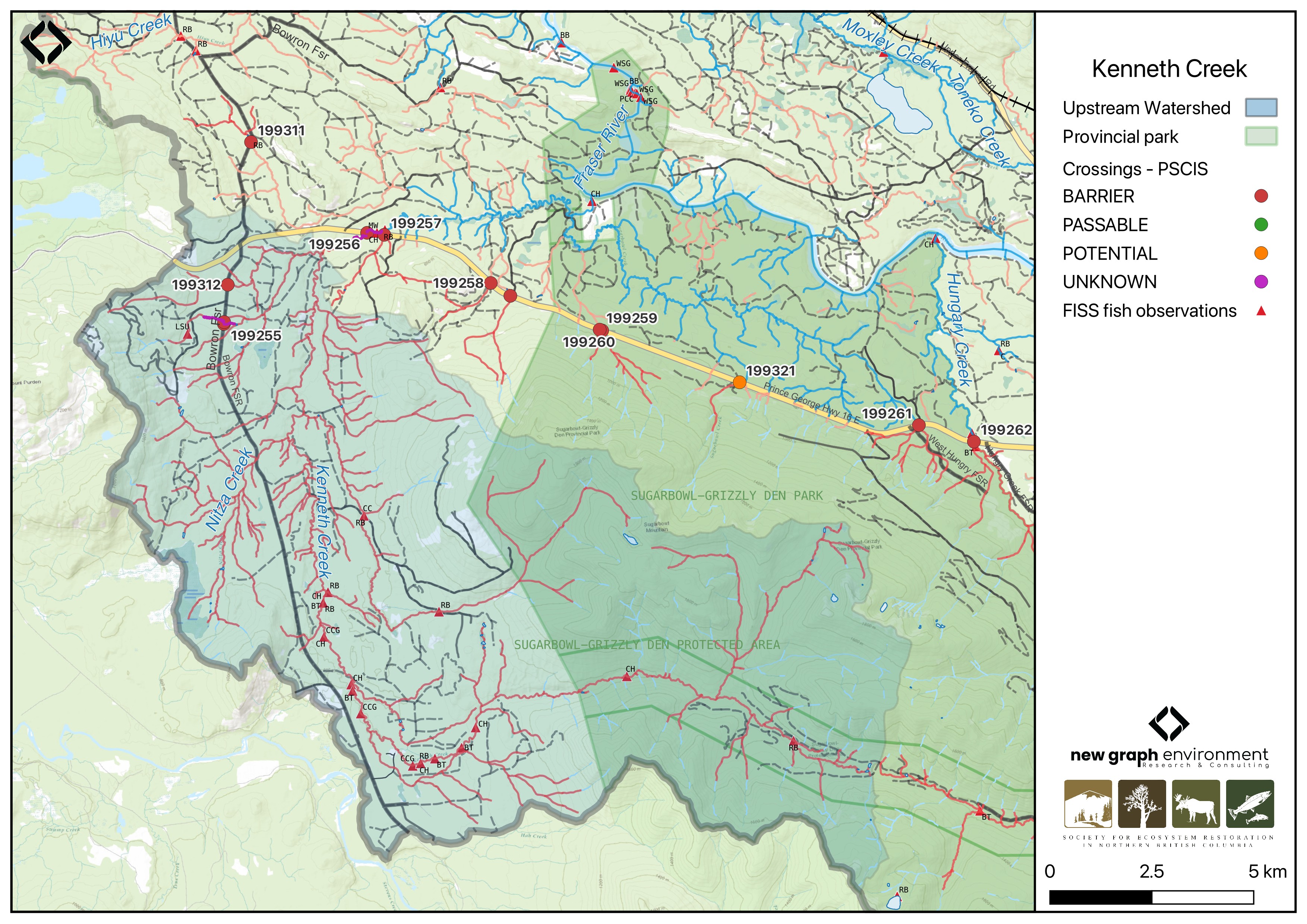
Figure 5.35: Map of Kenneth Creek
Background
At PSCIS crossing 199256, Kenneth Creek is a fifth order stream and drains a watershed of approximately 172km2. The watershed ranges in elevation from a maximum of 1886m to 655m near the crossing (Table 5.37).
The Kenneth Creek watershed was assessed in detail using Fish Habitat Assessment Procedures (FHAP) in 1997 by AquaFor Consulting Ltd (AquaFor Consulting Ltd 1998). Extensive degradation due to past forest harvesting was noted, with much of the watershed lacking future inputs of functional large woody debris—an element critical for maintaining channel and bank stability, diversifying habitat, and reducing stream velocities. Field observations indicated that the lower 15 reaches provide extremely valuable habitat for chinook salmon, and are also important for bull trout and rainbow trout. These reaches were all found to be severely impacted by past harvesting, with the most negative and cumulative impacts occurring where stream crossings were improperly located or poorly deactivated (if at all). AquaFor Consulting Ltd (1998) stated that although impacts varied across reaches, the system is actively degrading, and if restorative costs are to be best implemented, it should be done immediately to a system which is partially functioning, thereby most effectively minimizing costs and reducing the risks associated with failure of restorative activities.
In 2006, PSCIS crossing 199256 on Highway 16 was assessed with a fish passage assessment by DWB Forestry Services Ltd. and documented as a partial barrier due to high water velocities and an 8cm outlet drop (Hooft 2006). The culvert constricted the channel to less than half its natural width; however, upstream habitat was noted as high value, with chinook captured both upstream and downstream of the crossing. Hooft (2006) noted that although adult chinook salmon and rainbow trout could ascend at the observed velocities, they were likely impeded during higher spring flows.
Given the background information for this stream, in 2023, crossing 199256 was assessed with a fish passage assessment and prioritized for follow-up due to the presence of high-value habitat and chinook observations documented downstream in the FISS database (MoE 2024). Additionally, a dead chinook spawner was observed upstream of the Highway 16 culvert during an informal site visit in 2022. A habitat confirmation assessment was subsequently conducted in 2024.
In addition to chinook captured upstream of Highway 16 by Hooft (2006), longnose sucker, rainbow trout, chinook salmon, bull trout, sculpin (general), and slimy sculpin have previously been recorded (Norris [2018] 2024; MoE 2024). Also, there is Fisheries and Oceans Canada stock assessment data available for Kenneth Creek presented in Table 2.1 of the background section (Fisheries and Oceans Canada n.d.).
Water level, water temperature, discharge, and conductivity have been collected approximately 250m downstream of the Highway 16 crossing as part of the Northern BC Hydrology Research project (station 08KA0002). These data are publicly accessible at https://bcgov-env.shinyapps.io/nbchydro/.
A summary of habitat modelling outputs for the crossing are presented in Table 5.38.
fpr::fpr_table_wshd_sum(site_id = my_site) |>
  fpr::fpr_kable(caption_text = paste0('Summary of derived upstream watershed statistics for PSCIS crossing ', my_site, '.'),
           footnote_text = 'Elev P60 = Elevation at which 60% of the watershed area is above',
scroll = F)| Site | Area Km | Elev Site | Elev Min | Elev Max | Elev Median | Elev P60 | Aspect |
|---|---|---|---|---|---|---|---|
| 199256 | 172 | 655 | 619 | 1886 | 841 | 805 | S |
| * Elev P60 = Elevation at which 60% of the watershed area is above |
| Habitat | Potential | Remediation Gain | Remediation Gain (%) |
|---|---|---|---|
| CH Spawning (km) | 47.6 | 42.1 | 88 |
| CH Rearing (km) | 71.6 | 49.6 | 69 |
| CO Spawning (km) | 0.0 | 0.0 | – |
| CO Rearing (km) | 0.0 | 0.0 | – |
| CO Rearing (ha) | 0.0 | 0.0 | – |
| SK Spawning (km) | 0.0 | 0.0 | – |
| SK Rearing (km) | 0.0 | 0.0 | – |
| SK Rearing (ha) | 0.0 | 0.0 | – |
| BT Rearing (km) | 88.4 | 51.6 | 58 |
| BT Spawning (km) | 72.2 | 48.3 | 67 |
| * Model data is preliminary and subject to adjustments. |
Aerial Imagery
An aerial survey was conducted with a remotely piloted aircraft and the resulting imagery was processed into an orthomosaic available to view and download in Figure 5.36.
viewer_url <- '<iframe src="https://viewer.a11s.one/?cog=https://imagery-uav-bc.s3.amazonaws.com/fraser/nechacko/2024/199256_kenneth_hwy16/odm_orthophoto/odm_orthophoto.tif" scrolling="no" title="UAV Viewer" width="100%" height="600" frameBorder="0"></iframe>'

knitr::asis_output(viewer_url)
my_photo = 'fig/pixel.png'
my_caption = paste0('Orthomosaic of PSCIS crossing ', my_site, '.')
knitr::include_graphics(my_photo, dpi = NA)Figure 5.36: Orthomosaic of PSCIS crossing 199256.
Stream Characteristics at Crossing 199256
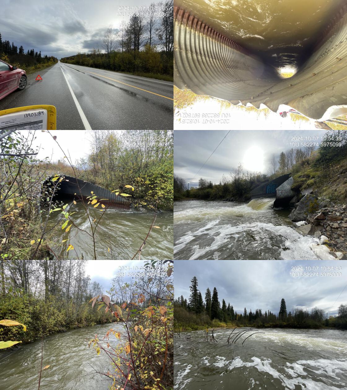
During the 2023 and 2024 assessments, PSCIS crossing 199256 on Highway 16 was un-embedded, non-backwatered and ranked as barrier to upstream fish passage according to the provincial protocol (MoE 2011) (Table 5.39). The culvert had a significant 0.7m outlet drop.
The water temperature was 6\(^\circ\)C, pH was 7.8 and conductivity was 201 uS/cm.
# fpr::fpr_table_cv_summary_memo()

# See issue https://github.com/NewGraphEnvironment/mybookdown-template/issues/65
fpr::fpr_table_cv_summary_memo()| Location and Stream Data |
|
Crossing Characteristics | – |
|---|---|---|---|
| Date | 2024-10-07 | Crossing Sub Type | Oval Culvert |
| PSCIS ID | 199256 | Diameter (m) | 5.5 |
| External ID | – | Length (m) | 30 |
| Crew | LS | Embedded | No |
| UTM Zone | 10 | Depth Embedded (m) | – |
| Easting | 582279 | Resemble Channel | No |
| Northing | 5975090 | Backwatered | No |
| Stream | Kenneth Creek | Percent Backwatered | – |
| Road | Highway 16 | Fill Depth (m) | 1.5 |
| Road Tenure | MOTI | Outlet Drop (m) | 0.7 |
| Channel Width (m) | 19 | Outlet Pool Depth (m) | 2 |
| Stream Slope (%) | 0.5 | Inlet Drop | No |
| Beaver Activity | No | Slope (%) | 1 |
| Habitat Value | High | Valley Fill | Deep Fill |
| Final score | 37 | Barrier Result | Barrier |
| Fix type | Replace with New Open Bottom Structure | Fix Span / Diameter | 24 |
| Comments: Large multi-plate oval culvert with a substantial 50m-wide outlet pool. Chinook, bull trout, and other species are documented upstream in the FISS database, and a dead chinook spawner was observed upstream of the crossing during an informal site visit in 2022. The stream had high flow at the time of assessment and the culvert slope and outlet pool depth were estimated as the pool was too deep to wade. Deep pools over 1m, formed by functional large woody debris, provided good overwintering habitat for fish of all ages. Gravels suitable for spawning were present. Downstream of the culvert, the stream ran parallel to the highway with banks reinforced by riprap and large wood secured with metal wiring to create habitat and reduce flow. The Kenneth Creek watershed was assessed in detail using Fish Habitat Assessment Procedures (FHAP) in 1997 by AquaFor Consulting Ltd., who identified the lower 15 reaches as extremely valuable chinook salmon habitat, also supporting bull trout and rainbow trout. MoTi chris_hwy_structure_road_id: 3750 | |||
| Photos: From top left clockwise: Road/Site Card, Barrel, Outlet, Downstream, Upstream, Inlet. | |||
|
Stream Characteristics Downstream of Crossing 199256
The stream was surveyed downstream from crossing 199256 for 370m (Figure 5.37). The habitat was rated as high value, with abundant spawning gravels and deep pools (>1m) formed by functional large woody debris, providing high-quality overwintering habitat for fish of all ages. The average channel width was 19m, the average wetted width was 16.1m, and the average gradient was 0.7%.The dominant substrate was cobbles with gravels sub-dominant.Total cover amount was rated as abundant with large woody debris dominant. Cover was also present as small woody debris, deep pools, and overhanging vegetation.
Downstream of the culvert, the stream ran parallel to the highway, with banks reinforced by riprap. Large wood, secured with metal wiring, was placed to create habitat and reduce flow, arranged in three sets of two logs spaced approximately 5m apart (Figure 5.39). These structures were likely installed to mitigate habitat loss caused by the riprapped banks.
Stream Characteristics Upstream of Crossing 199256
The stream was surveyed upstream from crossing 199256 for 950m (Figure 5.38). The habitat was rated as high value, with gravels suitable for chinook and resident salmonid spawning. The stream was large and gravel-dominated, with extensive deep runs, deep pools, large woody debris, and multiple channels throughout. The riparian area was intact throughout, consisting of a mix of shrub-dominated wetland areas and mature mixed forest. Total cover amount was rated as moderate with deep pools dominant. Cover was also present as small woody debris, large woody debris, undercut banks, and overhanging vegetation.The dominant substrate was gravels with cobbles sub-dominant.The average channel width was 22.8m, the average wetted width was 16.7m, and the average gradient was 0.8%.
Structure Remediation and Cost Estimate
Should restoration/maintenance activities proceed, replacement of the Highway 16 crossing (PSCIS 199256) with a bridge (24 m span) is recommended. At the time of reporting in 2025, the cost of the work is estimated at $ 18,000,000.
Conclusion
Kenneth Creek is a large, gravel-dominated stream with high-value habitat for salmonid spawning and rearing. Chinook and bull trout have been documented upstream of Highway 16 (Norris [2018] 2024; MoE 2024), and a dead chinook spawner was observed upstream of the Highway 16 culvert during an informal site visit in 2022. bcfishpass modeling indicates nearly 50km of potential chinook spawning habitat upstream of Highway 16. The crossing had a significant outlet drop which may inhibit passage for younger life stages of salmonids. Furthermore, high water velocities in the culvert, as reported by Hooft (2006), likely further inhibit upstream passage at the crossing. Fish sampling (electroshocking or eDNA sampling) is recommended to determine which anadromous species and life stages are currently able to ascend past the crossing.
Due to PSCIS crossing 199256 being located on highway 16, replacement of the crossing would be a large and expensive undertaking. Previous assessment by Hooft (2006) considered various mitigation options, including substrate placement, baffles, and downstream weirs, and concluded that replacement with a clear-spanning bridge or open-bottom structure is the only permanent solution to restore fish passage and address hydraulic concerns. The crossing is a high priority for replacement.
Given the stream’s ecological value, restoration concerns outlined in AquaFor Consulting Ltd (1998) should be explored and the streams overlap with Sugarbowl–Grizzly Den Provincial Park could add additional conservation relevance.
tab_hab_summary |>
  dplyr::filter(Site %in% c(my_site)) |>
  fpr::fpr_kable(caption_text = paste0("Summary of habitat details for PSCIS crossing ", my_site, "."),
scroll = F) | Site | Location | Length Surveyed (m) | Average Channel Width (m) | Average Wetted Width (m) | Average Pool Depth (m) | Average Gradient (%) | Total Cover | Habitat Value |
|---|---|---|---|---|---|---|---|---|
| 199256 | Downstream | 370 | 19.0 | 16.1 | 1.0 | 0.7 | abundant | high |
| 199256 | Upstream | 950 | 22.8 | 16.7 | 0.8 | 0.8 | moderate | high |
my_photo1 = fpr::fpr_photo_pull_by_str(str_to_pull = 'ds_typical_1_')

my_caption1 = paste0('Typical habitat downstream of PSCIS crossing ', my_site, '.')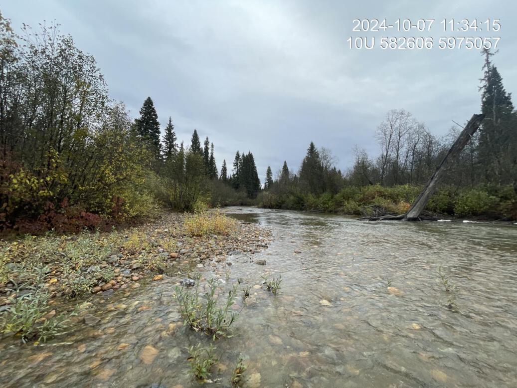
Figure 5.37: Typical habitat downstream of PSCIS crossing 199256.
my_photo2 = fpr::fpr_photo_pull_by_str(str_to_pull = 'us_typical_2_')

my_caption2 = paste0('Typical habitat upstream of PSCIS crossing ', my_site, '.')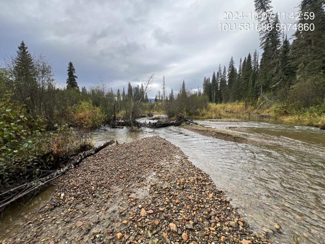
Figure 5.38: Typical habitat upstream of PSCIS crossing 199256.
my_caption <- paste0('Left: ', my_caption1, ' Right: ', my_caption2)

knitr::include_graphics(my_photo1)
knitr::include_graphics("fig/pixel.png")
knitr::include_graphics(my_photo2)
my_photo1 = fpr::fpr_photo_pull_by_str(str_to_pull = 'ds_logsandriprap')
my_caption1 = paste0('Ripwrapped banks and large wood structures secured with metal wiring located downstream of crossing ', my_site, '.')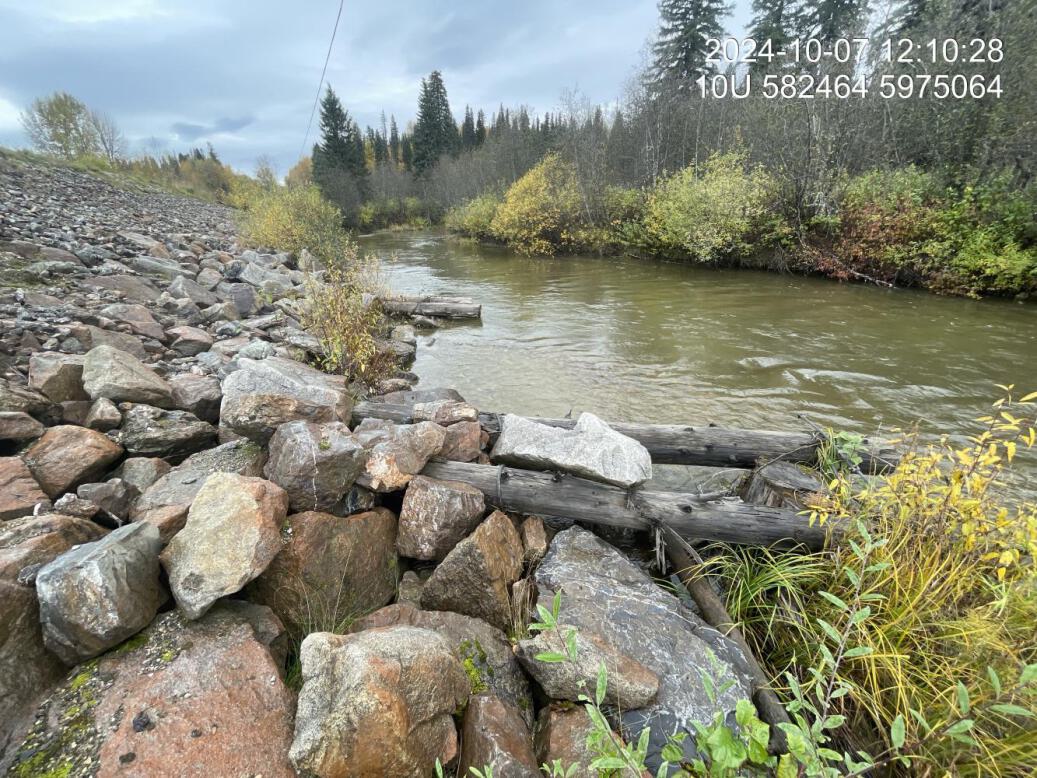
Figure 5.39: Ripwrapped banks and large wood structures secured with metal wiring located downstream of crossing 199256.