Teepee Creek - 199278 & 203302 - Appendix
Site Location
PSCIS crossings 199278 and 203302 are located on Teepee Creek, which flows into the McLennan River approximately 7km north of Valemount, BC, in the Upper Fraser River watershed group (Figure 5.46). Crossing 199278 is located 2.4km upstream of the McLennan River, on Highway 5, and is the responsibility of the Ministry of Transportation and Infrastructure (chris_culvert_id: 1467202). Approximately 300m upstream, PSCIS crossing 203302 is located on and is the responsibility of the CN Railway.
The headwaters of Teepee Creek overlap with Mount Terry Fox Provincial Park (“Mount Terry Fox Park” n.d.). Previously, access to the park was provided via the Mount Terry Fox Hiking Trail—a 16km out-and-back route gaining 1,740m in elevation on the hillside north of Teepee Creek, beginning near PSCIS crossing 4931 on Tinsley Pit Road (Caledonia Ramblers Hiking Club 2025). A newer trail now begins farther up the Teepee Creek drainage and follows the creek itself, connecting to a network of trails that can be used to access Mount Terry Fox with views of Mount Robson, as well as separate trails leading to alpine lakes and waterfalls. Additional information and downloadable GPX routes for the Teepee Creek trail are available here (Hike Valemount 2023).
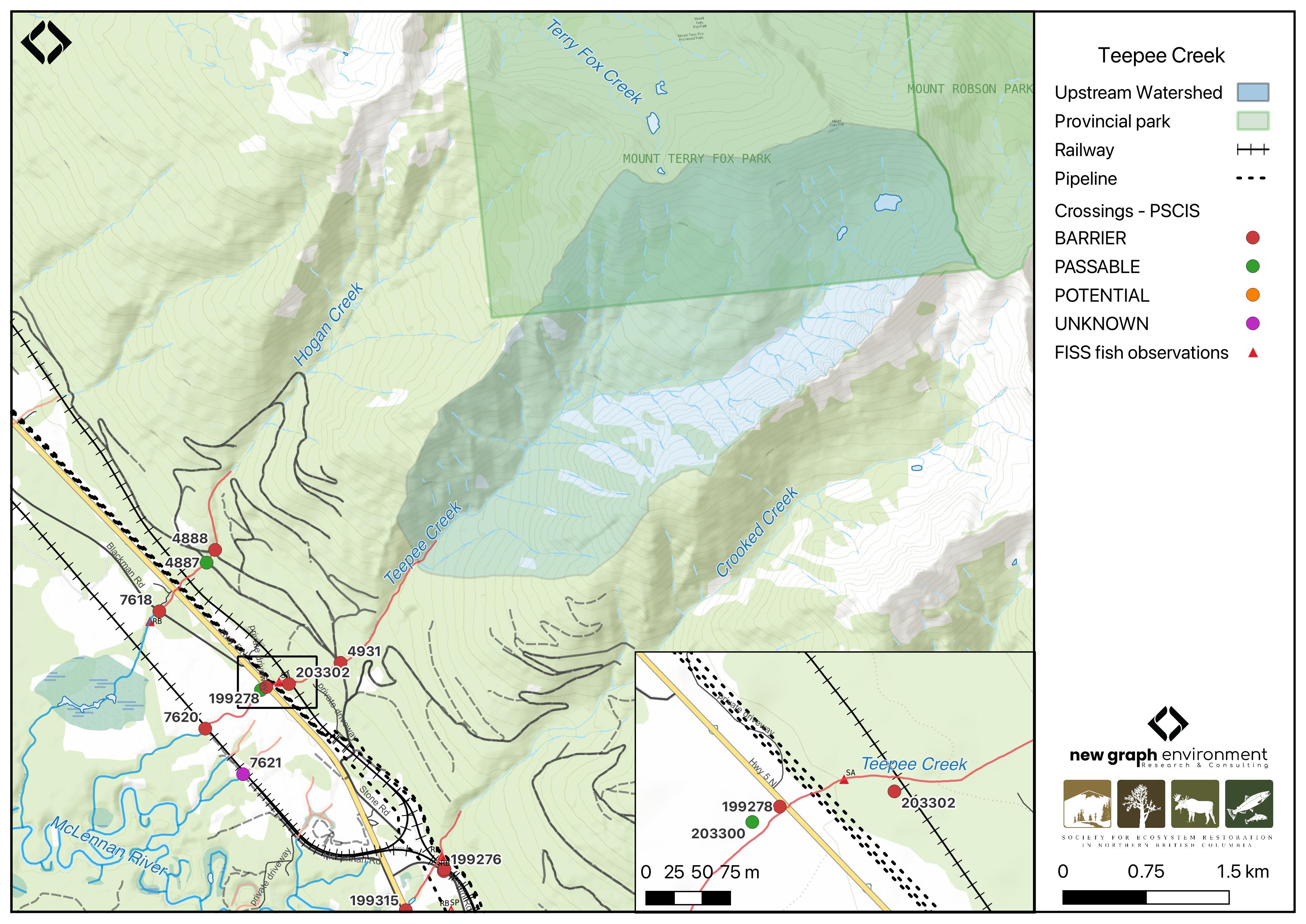
Figure 5.46: Map of Teepee Creek
Background
At PSCIS crossing 199278, Teepee Creek is a third order stream and drains a high elevation watershed of approximately 11km2. The watershed ranges in elevation from a maximum of 2648m to 798m near crossing 199278 (Table 5.49).
Bull trout were captured upstream and downstream of crossing 199278 on Highway 5 by Triton Environmental Consultants Ltd. in 2004 (Manson 2005), and again near the crossing by Applied Aquatic Research Ltd. in 2006 (Applied Aquatic Research 2006). Additionally, a salmon observation from 2012 is documented upstream of Highway 5 in the FISS database (MoE 2024).
In 2023, crossing 199278 was assessed with a fish passage assessment and prioritized for follow-up due to the presence of high-value habitat and known fish observation recorded upstream of the crossing as previously mentioned. A habitat confirmation assessment was subsequently conducted in 2024, encompassing crossing 199278 on Highway 5 as well as crossing 203302 located 300m upstream on the CN railway.
Downstream of Highway 5 on the CN railway, PSCIS crossing 7620 was initially assessed in 2007, and upstream of the highway, PSCIS crossing 4931 was initially assessed by Cliff Jackman Contracting Ltd. in 2010 (MoE 2023). Both crossings were reassessed with a fish passage assessment during the 2024 field visit.
fpr::fpr_table_wshd_sum(site_id = my_site) |>
  fpr::fpr_kable(caption_text = paste0('Summary of derived upstream watershed statistics for PSCIS crossing ', my_site, '.'),
           footnote_text = 'Elev P60 = Elevation at which 60% of the watershed area is above',
scroll = F)| Site | Area Km | Elev Site | Elev Min | Elev Max | Elev Median | Elev P60 | Aspect |
|---|---|---|---|---|---|---|---|
| 199278 | 11 | 798 | 988 | 2648 | 1949 | 1874 | SW |
| * Elev P60 = Elevation at which 60% of the watershed area is above |
| Habitat | Potential | Remediation Gain | Remediation Gain (%) |
|---|---|---|---|
| CH Spawning (km) | 0.0 | 0.0 | – |
| CH Rearing (km) | 0.0 | 0.0 | – |
| CO Spawning (km) | 0.0 | 0.0 | – |
| CO Rearing (km) | 0.0 | 0.0 | – |
| CO Rearing (ha) | 0.0 | 0.0 | – |
| SK Spawning (km) | 0.0 | 0.0 | – |
| SK Rearing (km) | 0.0 | 0.0 | – |
| SK Rearing (ha) | 0.0 | 0.0 | – |
| BT Rearing (km) | 0.5 | 0.2 | 40 |
| BT Spawning (km) | 0.0 | 0.0 | – |
| * Model data is preliminary and subject to adjustments. |
Stream Characteristics at Crossings 199278 and 203302
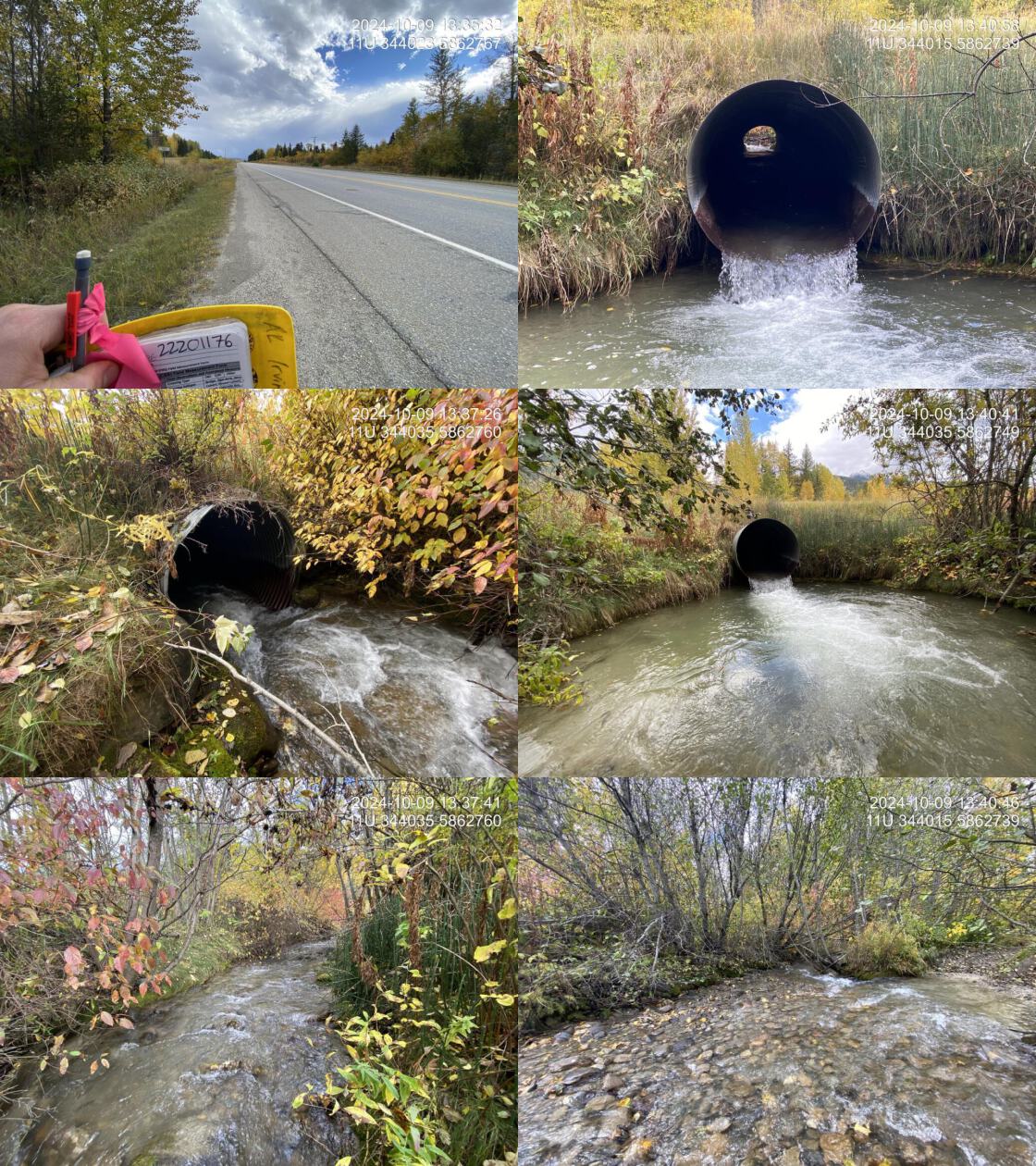
During the 2023 and 2024 assessments, PSCIS crossing 199278 on Highway 5 was un-embedded, non-backwatered and ranked as barrier to upstream fish passage according to the provincial protocol (MoE 2011) (Table 5.51). The culvert had a moderate 0.4m outlet drop.
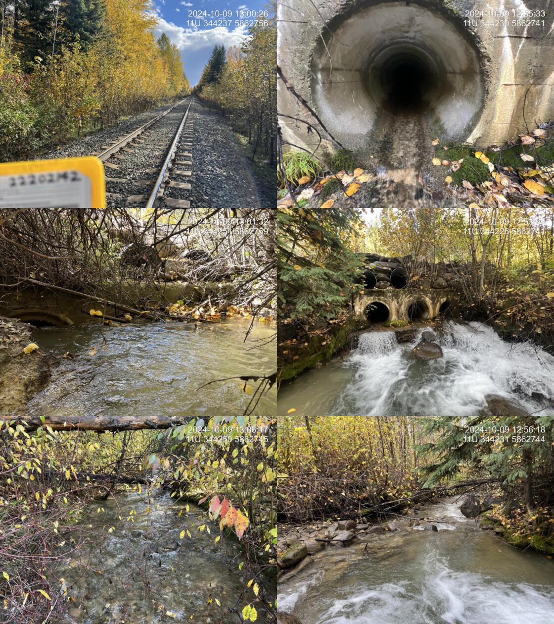
First assessed in 2024, PSCIS crossing 203302 on the CN Railway was un-embedded, non-backwatered and ranked as a barrier to upstream fish passage according to the provincial protocol (MoE 2011) (Table 5.52). This culvert had a significant 0.75m outlet drop.
In 2024, three other PSCIS crossings were assessed on Teepee Creek and can be found in Appendix - Phase 1 Fish Passage Assessment Data and Photos. Approximately 700m downstream of Highway 5, PSCIS crossing 7620 was located on the CN Railway (Figure 5.46). Although the crossing was ranked as a barrier to upstream fish passage according to the provincial protocol (MoE 2011), the culvert was embedded, 100% backwatered, and was not a barrier to fish passage at the time of the survey. Roughly 70m downstream of Highway 5, there was a small bridge on private land (PSCIS 203300)(Figure 5.46). Approximately 600m upstream of PSCIS crossing 203302 on the CN Railway, PSCIS crossing 4931 was located on Mount Tinsley Pit Road, which falls under the road tenure of Carrier Lumber R13564 (Figure 5.46). The culvert had a significant 1.3m outlet drop.
Water temperature was 4\(^\circ\)C, pH was 7.7 and conductivity was 243 uS/cm.
# fpr::fpr_table_cv_summary_memo()

# See issue https://github.com/NewGraphEnvironment/mybookdown-template/issues/65
fpr::fpr_table_cv_summary_memo()| Location and Stream Data |
|
Crossing Characteristics | – |
|---|---|---|---|
| Date | 2024-10-09 | Crossing Sub Type | Round Culvert |
| PSCIS ID | 199278 | Diameter (m) | 1.4 |
| External ID | – | Length (m) | 22 |
| Crew | LS | Embedded | No |
| UTM Zone | 11 | Depth Embedded (m) | – |
| Easting | 344031 | Resemble Channel | No |
| Northing | 5862744 | Backwatered | No |
| Stream | Teepee Creek | Percent Backwatered | – |
| Road | Highway 5 | Fill Depth (m) | 0.7 |
| Road Tenure | MOTI | Outlet Drop (m) | 0.4 |
| Channel Width (m) | 7 | Outlet Pool Depth (m) | 1 |
| Stream Slope (%) | 2.5 | Inlet Drop | No |
| Beaver Activity | No | Slope (%) | 2 |
| Habitat Value | High | Valley Fill | Deep Fill |
| Final score | 34 | Barrier Result | Barrier |
| Fix type | Replace with New Open Bottom Structure | Fix Span / Diameter | 15 |
| Comments: A moderate outlet drop was present and would be substantial at lower flows. Flow was steady at the time of assessment. The culvert was in good condition. A large, deep outlet pool indicated the culvert was likely undersized for the stream. Additionally, minimal road fill made this crossing a significant flood hazard, which could wash out Highway 5. Downstream, the stream had frequent pools 0.3-0.5m deep, providing good overwintering habitat for fish, and abundant gravels suitable for spawning. Roughly 150m downstream of the culvert, several cattle pens crossed the stream and appeared to be set up to provide cattle access for drinking. These areas were visibly trampled, with significant loss of riparian vegetation. Upstream, the stream was relatively confined, with only rare pockets of unembedded gravels. Deep pools were present, formed by boulder and large woody debris scour. Numerous small steps, ranging from 30-60cm, were present due to the steep, boulder-dominated nature of the stream. A salmon point was noted near the pipeline location in FISS. Bull trout have previously been captured both upstream and downstream of the highway crossing by Triton Environmental Consultants Ltd. Electrofishing would be beneficial for further assessment. The site was a highway crossing, making replacement difficult. Upstream of the Mount Tinsley Pit Road crossing, a hiking trail follows Teepee Creek and provides access to Mount Terry Fox Provincial Park. MoTi chris_culvert_id: 1467202 | |||
| Photos: From top left clockwise: Road/Site Card, Barrel, Outlet, Downstream, Upstream, Inlet. | |||
|
# fpr::fpr_table_cv_summary_memo(site = my_site2, site_photo_id = my_site2)

# See issue https://github.com/NewGraphEnvironment/mybookdown-template/issues/65
fpr::fpr_table_cv_summary_memo(site = my_site2, site_photo_id = my_site2)| Location and Stream Data |
|
Crossing Characteristics | – |
|---|---|---|---|
| Date | 2024-10-09 | Crossing Sub Type | Round Culvert |
| PSCIS ID | 203302 | Diameter (m) | 2.7 |
| External ID | – | Length (m) | 14 |
| Crew | AI | Embedded | No |
| UTM Zone | 11 | Depth Embedded (m) | – |
| Easting | 344222 | Resemble Channel | No |
| Northing | 5862742 | Backwatered | No |
| Stream | Teepee Creek | Percent Backwatered | – |
| Road | Railway | Fill Depth (m) | 2 |
| Road Tenure | CN Rail | Outlet Drop (m) | 0.75 |
| Channel Width (m) | 4.2 | Outlet Pool Depth (m) | 0.25 |
| Stream Slope (%) | 7 | Inlet Drop | Yes |
| Beaver Activity | No | Slope (%) | 6 |
| Habitat Value | Medium | Valley Fill | Deep Fill |
| Final score | 36 | Barrier Result | Barrier |
| Fix type | Replace with New Open Bottom Structure | Fix Span / Diameter | 15 |
| Comments: Three concrete pipes, each 0.9m in diameter, were present, along with two 0.9m corrugated overflow pipes above. A stamp on the structure indicated it was built in 1944. All three concrete pipes were clogged at the inlet, ranging from 80% to 100% clogged with debris. This is a known fish-bearing stream, with a salmon point documented ~100m downstream in the FISS database. At this location, the stream was a mid-sized, steeper cobble-boulder step-pool system with only rare pockets of unembedded gravels. Deep pools were present, formed by boulder and large woody debris scour. Numerous small steps, ranging from 30-60cm, were present due to the steep, boulder-dominated nature of the stream. Downstream of the highway crossing, the stream had a lower gradient with frequent pools 0.3-0.5m deep, providing good overwintering habitat for fish and abundant gravels suitable for spawning. Bull trout have previously been captured both upstream and downstream of the highway 5 crossing by Triton Environmental Consultants Ltd. Upstream of the Mount Tinsley Pit Road crossing, a hiking trail follows Teepee Creek and provides access to Mount Terry Fox Provincial Park. | |||
| Photos: From top left clockwise: Road/Site Card, Barrel, Outlet, Downstream, Upstream, Inlet. | |||
|
Stream Characteristics Downstream of Crossing 199278
The stream was surveyed downstream from crossing 199278 for 150m (Figure 5.47). The habitat was rated as high value, with with frequent pools 0.3 – 0.5m deep suitable for overwintering fish and abundant gravels for spawning. Total cover amount was rated as abundant with large woody debris dominant. Cover was also present as small woody debris, undercut banks, and overhanging vegetation.The dominant substrate was cobbles with gravels sub-dominant.The average channel width was 7.1m, the average wetted width was 4.5m, and the average gradient was 2.5%. Roughly 150m downstream of the culvert, several cattle pens crossed the stream and appeared to be set up to provide cattle access for drinking. These areas were visibly trampled, with significant loss of riparian vegetation.
Stream Characteristics Upstream of Crossing 199278 and Downstream of Crossing 203302
The stream was surveyed upstream from crossing 199278 on Highway 5 to crossing 203302 on the CN Railway, a distance of approximately 300m (Figure 5.48). The habitat was rated as medium value for spawning and rearing, with frequent deep pools formed by boulders and large woody debris, but only limited pockets of unembedded gravels. Numerous small steps ranging from 30 – 60cm were present due to the steep, boulder-dominated nature of the stream. The average channel width was 5.3m, the average wetted width was 3.3m, and the average gradient was 7.2%.Total cover amount was rated as moderate with boulders dominant. Cover was also present as large woody debris, undercut banks, and overhanging vegetation.The dominant substrate was cobbles with boulders sub-dominant.
Stream Characteristics Upstream of Crossing 203302
The stream was surveyed upstream from crossing 203302 for 600m (Figure 5.49). The habitat was rated as medium value for spawning and rearing, with few unembedded gravels; however, recent heavy rain caused slight turbidity making it difficult to assess the substrate. The average channel width was 5.4m, the average wetted width was 3.9m, and the average gradient was 6.8%.The dominant substrate was cobbles with boulders sub-dominant.Total cover amount was rated as moderate with boulders dominant. Cover was also present as . Approximately 100m before the end of the site, the stream showed signs of a large disturbance event that had incised the channel to a depth of 1.2 – 2m, with major areas of aggregation where the channel was widened and uniform.
Structure Remediation and Cost Estimate
Should restoration/maintenance activities proceed, replacement of the Highway 5 crossing (199278) with a bridge (15 m span) is recommended. At the time of reporting in 2025, the cost of the work is estimated at $ 11,250,000.
Should restoration/maintenance activities proceed, replacement of the Railway crossing (203302) with a bridge (15 m span) is recommended. At the time of reporting in 2025, the cost of the work is estimated at $ 11,250,000.
Conclusion
PSCIS crossing 199278 on Highway 5 had a moderate outlet drop that could be substantial at lower flows. A large, deep outlet pool indicated the culvert was likely undersized for the stream, and minimal road fill made this crossing a significant flood hazard which could wash out Highway 5, a major transportation route. The crossing is a high priority for replacement. A further 300m upstream, PSCIS crossing 203302 on the CN Railway had a substantial outlet drop, which may inhibit passage for younger life stages of salmonids. This crossing is a moderate priority for replacement. The documented fish observation recorded upstream of the Highway 5 crossing indicate that this stream has provided valuable fish habitat (Manson 2005; MoE 2024). Given the species present in the system and the outlet drops at both crossings, fish sampling is recommended to assess whether the culverts are impeding fish passage.
Downstream of PSCIS crossing 199278 on Highway 5, heavy cattle activity has resulted in visibly trampled streambanks and significant loss of riparian vegetation. Additional signs of cattle disturbance were observed further downstream near PSCIS crossing 7620. This lower section of Teepee Creek presents an opportunity for riparian restoration to exclude cattle from the stream through measures such as fencing and the installation of offsite watering systems. Given the stream’s proximity to the Village of Valemount, landowner engagement through education and restoration initiatives should be explored. Furthermore, with Mount Terry Fox Provincial Park and the Teepee Creek trail network located upstream, crossing replacement and habitat restoration efforts could align with broader conservation goals and community initiatives, increasing the likelihood of funding and sustained project momentum.
tab_hab_summary |>
  dplyr::filter(Site %in% c(my_site, my_site2)) |>
  fpr::fpr_kable(caption_text = paste0("Summary of habitat details for PSCIS crossings ", my_site, " and ", my_site2, "."),
scroll = F) | Site | Location | Length Surveyed (m) | Average Channel Width (m) | Average Wetted Width (m) | Average Pool Depth (m) | Average Gradient (%) | Total Cover | Habitat Value |
|---|---|---|---|---|---|---|---|---|
| 199278 | Downstream | 150 | 7.1 | 4.5 | 0.3 | 2.5 | abundant | high |
| 199278 | Upstream | 310 | 5.3 | 3.3 | 0.4 | 7.2 | moderate | medium |
| 203302 | Upstream | 600 | 5.4 | 3.9 | 0.4 | 6.8 | moderate | medium |
my_photo1 = fpr::fpr_photo_pull_by_str(str_to_pull = 'ds_typical_1_')

my_caption1 = paste0('Typical habitat downstream of PSCIS crossing ', my_site, '.')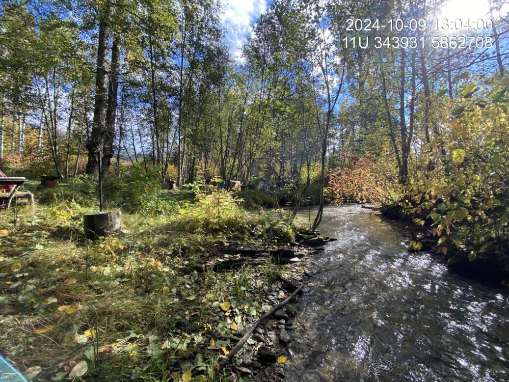
Figure 5.47: Typical habitat downstream of PSCIS crossing 199278.
my_photo2 = fpr::fpr_photo_pull_by_str(str_to_pull = 'us_typical_1_')

my_caption2 = paste0('Typical habitat upstream of PSCIS crossing ', my_site, ' and downstream of PSCIS crossing ', my_site2, '.')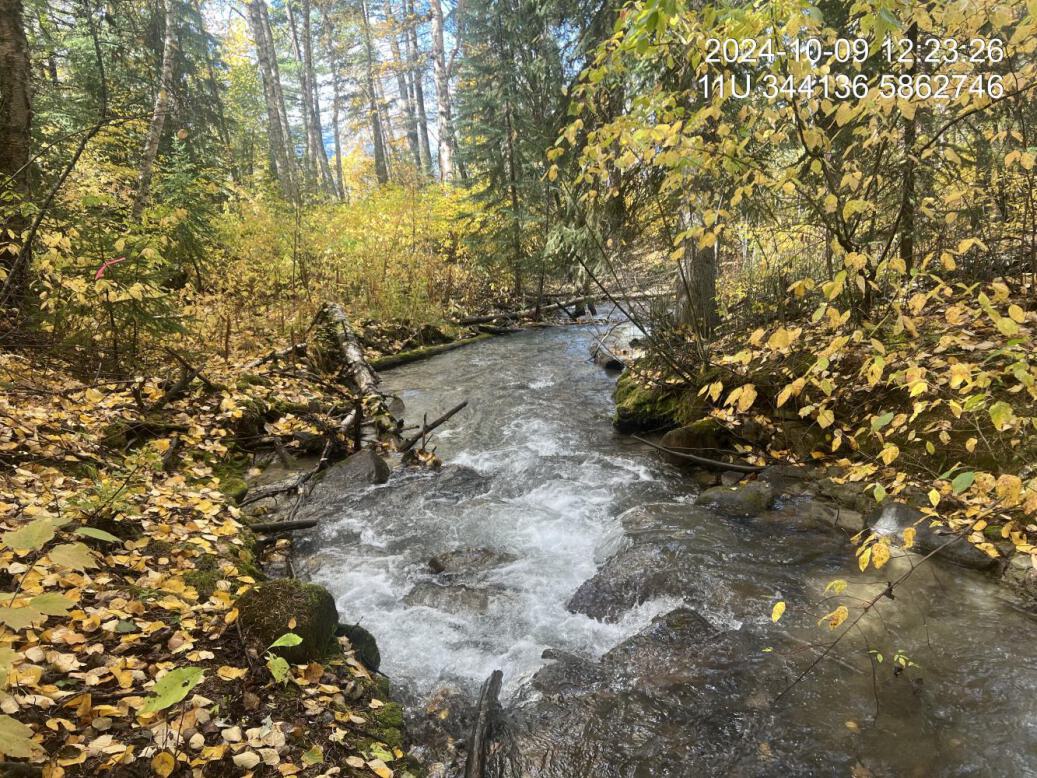
Figure 5.48: Typical habitat upstream of PSCIS crossing 199278 and downstream of PSCIS crossing 203302.
my_caption <- paste0('Left: ', my_caption1, ' Right: ', my_caption2)

knitr::include_graphics(my_photo1)
knitr::include_graphics("fig/pixel.png")
knitr::include_graphics(my_photo2)
my_photo1 = fpr::fpr_photo_pull_by_str(site = my_site2, str_to_pull = 'us_typical_1_')
my_caption1 = paste0('Typical habitat upstream of PSCIS crossing ', my_site2, '.')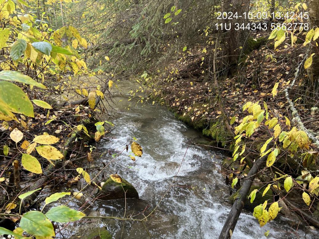
Figure 5.49: Typical habitat upstream of PSCIS crossing 203302.
my_caption <- paste0('Left: ', my_caption1, ' Right: ', my_caption2)

knitr::include_graphics(my_photo1)
knitr::include_graphics("fig/pixel.png")
knitr::include_graphics(my_photo2)