Tributary To Nechako River - 199173 & 199174 - Appendix
Site Location
PSCIS crossings 199173 and 199174 are located on Tributary To Nechako River, approximately 4km northeast of the Nadleh Whut’en First Nations community near Fraser Lake, BC, in the Nechako River watershed group (Figure 5.12). Crossing 199173 is located 115m upstream of the Nechako River, on Dog Creek Road, and is the responsibility of the Ministry of Transportation and Infrastructure (chris_culvert_id: 1794340). A further 2km upstream, PSCIS crossing 199174 is located on Sutherland FSR and is the responsibility of the Ministry of Forests. The downstream 200m of the stream is incorrectly mapped in the BC Freshwater Atlas, and flows directly south to join the Nechako River (see Survey Track in Figure 5.12) rather than following the mapped route, which runs east along Dog Creek Road before joining the Nechako River.
 my_caption <- "Map of tributary to Nechako River"

 knitr::include_graphics("fig/gis/map_trib_to_nechako.jpeg")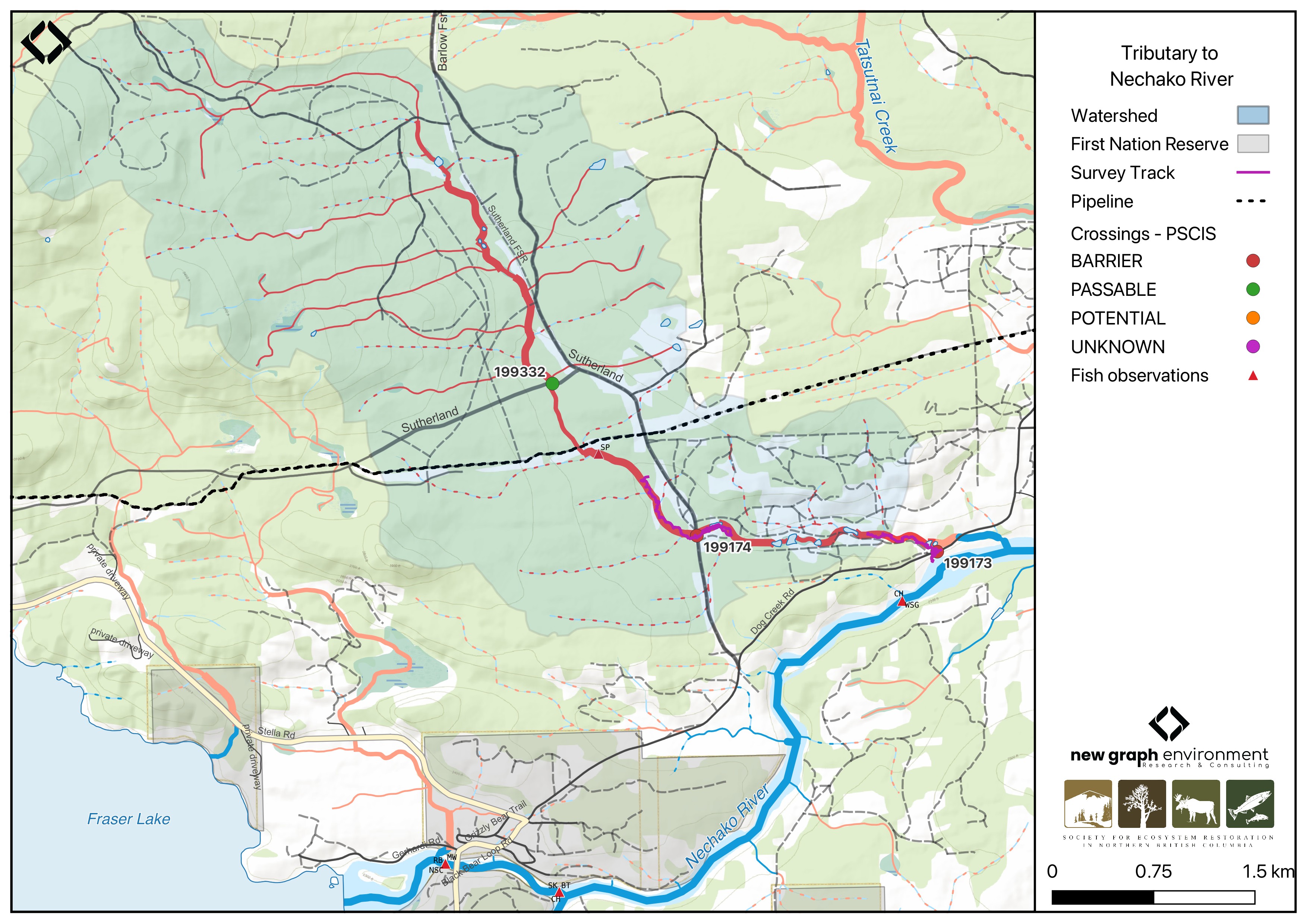
Figure 5.12: Map of tributary to Nechako River
Background
At the location of these crossings, Tributary To Nechako River is a third order stream and drains a watershed of approximately 15km2. The watershed ranges in elevation from a maximum of 1191m to 680m near the downstream crossing (Table 5.12).
Since 2020, an ongoing environmental DNA (eDNA) project led by Dr. Brent Murray and Barry Booth, R.P.Bio at UNBC, in collaboration with School District (SD) 91, has conducted fish sampling in the Nechako River watershed, including on Tributary To Nechako River. Minnow trapping in 2022 captured chinook just upstream of the crossing on Dog Creek Road (Booth 2023). Additionally, minnow trapping in 2021 and 2023 captured chinook in the ~100m section of stream from Dog Creek Road downstream to the Nechako River (Booth 2022, 2024), with eDNA results from 2021 and 2023 also showing a strong detection for chinook in this section (B. Murray and Booth 2024; B. W. Murray and Booth 2023).
In 2023, both crossings were assessed with fish passage assessments and prioritized for follow-up in 2024 based on the presence of high-value habitat adjacent to Dog Creek Road and supporting information from B. Murray and Booth (2024) and B. W. Murray and Booth (2023). Habitat confirmation assessments were completed at both sites in 2024. A third site, PSCIS crossing 199332, was also assessed in 2023. Located approximately 1.7km upstream of the Sutherland FSR crossing on Williams FSR, the site consisted of a bridge with evidence of extensive cattle trampling below. Assessment results from 2023 are presented in Appendix - Phase 1 Fish Passage Assessment Data and Photos.
A summary of habitat modelling outputs for the crossing are presented in Table 5.13.
fpr::fpr_table_wshd_sum(site_id = my_site) |>
  fpr::fpr_kable(caption_text = paste0('Summary of derived upstream watershed statistics for PSCIS crossing ', my_site, '.'),
           footnote_text = 'Elev P60 = Elevation at which 60% of the watershed area is above',
scroll = F)| Site | Area Km | Elev Site | Elev Min | Elev Max | Elev Median | Elev P60 | Aspect |
|---|---|---|---|---|---|---|---|
| 199173 | 15 | 680 | 671 | 1191 | 814 | 801 | SE |
| * Elev P60 = Elevation at which 60% of the watershed area is above |
| Habitat | Potential | Remediation Gain | Remediation Gain (%) |
|---|---|---|---|
| CH Spawning (km) | 0.0 | 0.0 | – |
| CH Rearing (km) | 0.0 | 0.0 | – |
| CO Spawning (km) | 4.0 | 0.6 | 15 |
| CO Rearing (km) | 5.5 | 0.6 | 11 |
| CO Rearing (ha) | 0.0 | 0.0 | – |
| SK Spawning (km) | 0.0 | 0.0 | – |
| SK Rearing (km) | 0.0 | 0.0 | – |
| SK Rearing (ha) | 0.0 | 0.0 | – |
| BT Rearing (km) | 6.2 | 0.8 | 13 |
| BT Spawning (km) | 4.0 | 0.6 | 15 |
| * Model data is preliminary and subject to adjustments. |
Aerial Imagery
Aerial surveys were conducted with a remotely piloted aircraft and the resulting imagery was processed into orthomosaics. Imagery is available to view and download for PSCIS crossing 199173 on Dog Creek Road in Figure 5.13.
#text for 199174 UAV once we move to a bigger server - see https://github.com/NewGraphEnvironment/stac_uav_bc/issues/8

# and PSCIS crossing `r as.character(my_site2)` on `r fpr_my_pscis_info(col_pull = road_name, site = my_site2)` `r if(gitbook_on){knitr::asis_output("in Figure \\@ref(fig:uav-ortho-199174)")}else(knitr::asis_output("[here](https://viewer.a11s.one/?cog=https://imagery-uav-bc.s3.amazonaws.com/fraser/nechacko/2024/199174_necr_trib_dog_settlement/odm_orthophoto/odm_orthophoto.tif)"))`.
viewer_url <- '<iframe src="https://viewer.a11s.one/?cog=https://imagery-uav-bc.s3.amazonaws.com/fraser/nechacko/2024/199173_necr_trib_dog/odm_orthophoto/odm_orthophoto.tif" scrolling="no" title="UAV Viewer" width="100%" height="600" frameBorder="0"></iframe>'
knitr::asis_output(viewer_url)my_photo = 'fig/pixel.png'
my_caption = paste0('Orthomosaic of PSCIS crossing ', my_site, '.')
knitr::include_graphics(my_photo, dpi = NA)Figure 5.13: Orthomosaic of PSCIS crossing 199173.
viewer_url <- '<iframe src="https://viewer.a11s.one/?cog=https://imagery-uav-bc.s3.amazonaws.com/fraser/nechacko/2024/199174_necr_trib_dog_settlement/odm_orthophoto/odm_orthophoto.tif" scrolling="no" title="UAV Viewer" width="100%" height="600" frameBorder="0"></iframe>'

knitr::asis_output(viewer_url)
my_photo = 'fig/pixel.png'
my_caption = paste0('Orthomosaic of PSCIS crossing ', my_site2, '.')
knitr::include_graphics(my_photo, dpi = NA)Figure 5.14: FALSE
Stream Characteristics at Crossings 199173 and 199174
At the time of the 2024 assessment, PSCIS crossing 199173 on Dog Creek Road was un-embedded, non-backwatered and ranked as a barrier to upstream fish passage according to the provincial protocol (MoE 2011) (Table 5.14). The culvert had a moderate 0.35m outlet drop.
PSCIS crossing 199174 on Sutherland FSR was un-embedded, non-backwatered and ranked as a barrier to upstream fish passage according to the provincial protocol (MoE 2011) (Table 5.15). The stream was dry at the crossing location at the time of assessment.
Water temperature was 6\(^\circ\)C, pH was 8.2 and conductivity was 34 uS/cm.
# fpr::fpr_table_cv_summary_memo()

# See issue https://github.com/NewGraphEnvironment/mybookdown-template/issues/65
fpr::fpr_table_cv_summary_memo()| Location and Stream Data |
|
Crossing Characteristics | – |
|---|---|---|---|
| Date | 2024-09-15 | Crossing Sub Type | Round Culvert |
| PSCIS ID | 199173 | Diameter (m) | 0.9 |
| External ID | – | Length (m) | 10 |
| Crew | LS, AI | Embedded | No |
| UTM Zone | 10 | Depth Embedded (m) | – |
| Easting | 398923 | Resemble Channel | No |
| Northing | 5996362 | Backwatered | No |
| Stream | Tributary To Nechako River | Percent Backwatered | – |
| Road | Dog Creek Road | Fill Depth (m) | 1 |
| Road Tenure | MOTI | Outlet Drop (m) | 0.35 |
| Channel Width (m) | 3 | Outlet Pool Depth (m) | 0.7 |
| Stream Slope (%) | 4 | Inlet Drop | No |
| Beaver Activity | Yes | Slope (%) | 2.5 |
| Habitat Value | Medium | Valley Fill | Deep Fill |
| Final score | 31 | Barrier Result | Barrier |
| Fix type | Replace with New Open Bottom Structure | Fix Span / Diameter | 15 |
| Comments: The culvert had a moderate outlet drop with some erosion around the pipe at the outlet. The pipe was in good condition. The stream provided excellent habitat, with several pools and abundant undercut banks. Fish were observed during the assessment (~40-90mm in length), and chinook have been captured upstream of this crossing as part of an ongoing environmental DNA (eDNA) project led by Dr. Brent Murray and Barry Booth at UNBC. Upstream of the crossing, the stream was channelized with some pockets of gravel suitable for rearing rainbow trout and potentially chinook. It then transitioned into beaver-impounded wetland areas storing large quantities of water, likely sustaining year-round stream flow at this crossing. There was extensive cattle trampling around the inlet of the pipe and throughout the surveyed upstream area. The crossing was located approximately 150m upstream from the Nechako River mainstem. The lower 200m of the stream is incorrectly mapped in the BC Freshwater Atlas. Instead of flowing east along Dog Creek Road as mapped, the stream flows south, crosses Dog Creek Road, and joins the Nechako River. MoTi chris_culvert_id: 1794340 | |||
| Photos: From top left clockwise: Road/Site Card, Barrel, Outlet, Downstream, Upstream, Inlet. | |||
|
# fpr::fpr_table_cv_summary_memo(site = my_site2, site_photo_id = my_site2)

# See issue https://github.com/NewGraphEnvironment/mybookdown-template/issues/65
fpr::fpr_table_cv_summary_memo(site = my_site2, site_photo_id = my_site2)| Location and Stream Data |
|
Crossing Characteristics | – |
|---|---|---|---|
| Date | 2024-09-15 | Crossing Sub Type | Round Culvert |
| PSCIS ID | 199174 | Diameter (m) | 1.5 |
| External ID | – | Length (m) | 15 |
| Crew | LS | Embedded | No |
| UTM Zone | 10 | Depth Embedded (m) | – |
| Easting | 397160 | Resemble Channel | No |
| Northing | 5996574 | Backwatered | No |
| Stream | Tributary To Nechako River | Percent Backwatered | – |
| Road | Sutherland FSR | Fill Depth (m) | 0.4 |
| Road Tenure | MoF | Outlet Drop (m) | 0 |
| Channel Width (m) | 2.5 | Outlet Pool Depth (m) | 0 |
| Stream Slope (%) | 1.2 | Inlet Drop | No |
| Beaver Activity | No | Slope (%) | 1 |
| Habitat Value | Medium | Valley Fill | Deep Fill |
| Final score | 24 | Barrier Result | Barrier |
| Fix type | Replace with New Open Bottom Structure | Fix Span / Diameter | 15 |
| Comments: At the time of assessment, the stream was dry at the crossing, though medium-value habitat was present. Upstream, the channel remained mostly dry for the first 300m before intermittent pools associated with beaver activity appeared. By approximately 450-500m upstream, the stream was nearly fully watered, with pools up to 40cm deep. Downstream of the crossing, the channel transitioned into beaver-impounded wetland habitat storing substantial water volumes, likely supporting year-round flow at the downstream Dog Creek Road crossing (PSCIS 199173). Further downstream, approximately 300m upstream of the crossing on Dog Creek Road, the stream transitioned to a channelized system with some pockets of gravel suitable for rearing rainbow trout and potentially Chinook. Heavy cattle impacts were observed at both this crossing and the downstream crossing on Dog Creek Road. Chinook have been captured upstream of the crossing of Dog Creek Road (PSCIS 199173) as part of an ongoing environmental DNA (eDNA) project led by Dr. Brent Murray and Barry Booth at UNBC. | |||
| Photos: From top left clockwise: Road/Site Card, Barrel, Outlet, Downstream, Upstream, Inlet. | |||
|
##this is useful to get some comments for the report
hab_site |>filter(site == my_site & location == 'ds') |>pull(comments)
hab_site |>filter(site == my_site & location == 'us') |>pull(comments)
hab_site |>filter(site == my_site2 & location == 'ds') |>pull(comments)
hab_site |>filter(site == my_site2 & location == 'us') |>pull(comments)
Stream Characteristics Downstream of Crossing 199173
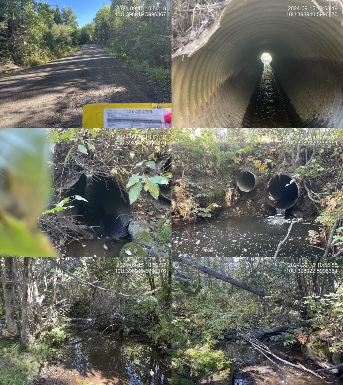
The stream was surveyed downstream from crossing 199173 for 115m (Figure 5.15). The habitat was rated as medium value, with undercut banks suitable for juvenile chinook and rainbow trout rearing. No natural or man-made barriers were present between Dog Creek Road and the Nechako River. Fish (~40 – 90mm in length) were observed during the assessment. The dominant substrate was cobbles with fines sub-dominant.Total cover amount was rated as moderate with undercut banks dominant. Cover was also present as small woody debris and boulders.The average channel width was 3.5m, the average wetted width was 1.3m, and the average gradient was 6%.
Stream Characteristics Upstream of Crossing 199173 and Downstream of Crossing 199174
The stream was surveyed upstream from crossing 199173 for 575m (Figure 5.16). The habitat was rated as medium with pockets of gravels suitable for rainbow trout and potentially chinook rearing, and fish were observed throughout the survey area. Heavy cattle impacts were evident, particularly in low-gradient sections with easily accessible banks. Fencing intended to restrict cattle access was present but had been breached. Approximately 300–350m upstream, the stream transitioned from a channelized section to a beaver-impounded wetland, with over three mature dams — some up to 1.5m high — vegetated and well-developed. These dams impounded large volumes of water, likely sustaining year-round stream flow downstream at the Dog Creek Road crossing. Total cover amount was rated as moderate with small woody debris dominant. Cover was also present as large woody debris, deep pools, and overhanging vegetation.The average channel width was 3m, the average wetted width was 1.5m, and the average gradient was 2.4%.
The stream was surveyed downstream from crossing 199174 for 300m (Figure 5.17). The stream was intermittent for the first ~70m before transitioning into a beaver-impacted wetland area. Approximately 250m downstream of Sutherland FSR, several large, mature, consecutive beaver dams were present and appeared to continue as far as the area surveyed. Signs of cattle trampling were observed throughout the stream, and the channel frequently split into several smaller channels. The habitat was rated as medium value, with few gravels for spawning but abundant pools created by beaver dams. Total cover amount was rated as abundant with small woody debris dominant. Cover was also present as large woody debris, undercut banks, deep pools, and overhanging vegetation.The average channel width was 2m, the average wetted width was 1m, and the average gradient was 1.2%.The dominant substrate was fines with gravels sub-dominant.
Stream Characteristics Upstream of Crossing 199174
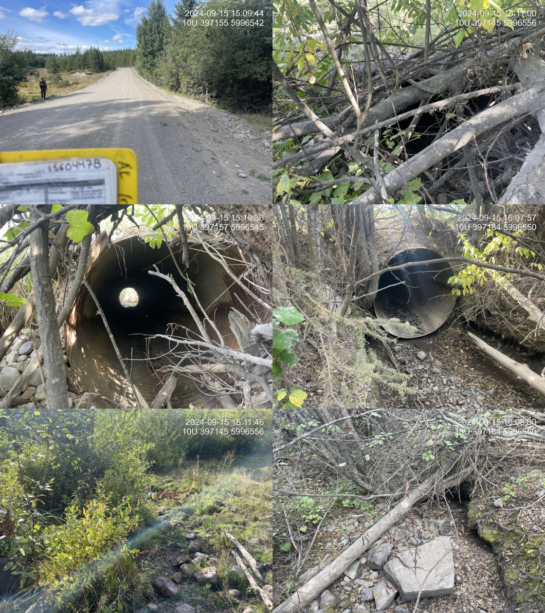
The stream was surveyed upstream from crossing 199174 for 650m (Figure 5.18). The habitat was rated as medium value and had been heavily impacted by cattle, with evidence of bank trampling and extensive low-gradient muddy sections. Upstream of the culvert, the stream was primarily dry for the first 300m, with young forest and shrub riparian. At this point, intermittent pools began to appear, associated with beaver activity. At approximately 450 – 500m upstream, the stream became almost entirely watered, with pools up to 40cm deep. Many surveyed areas resembled wetland habitat, with spirea, willow, alder, and trembling aspen throughout. The dominant substrate was fines with gravels sub-dominant.Total cover amount was rated as moderate with undercut banks dominant. Cover was also present as small woody debris and overhanging vegetation.The average channel width was 2.5m, the average wetted width was 0.9m, and the average gradient was 1.2%.
Structure Remediation and Cost Estimate
Should restoration/maintenance activities proceed, replacement of the Dog Creek Road crossing (199173) with a bridge (15 m span) is recommended. At the time of reporting in 2025, the cost of the work is estimated at $ 1,500,000.
At the time of assessment, the upstream crossing on Sutherland FSR was unlikely a barrier to fish passage, and restoration efforts should prioritize the downstream crossing on Dog Creek Road. However, should restoration activities proceed at crossing 199174, replacement with a bridge spanning 15 m is recommended. At the time of reporting in 2025, the estimated cost for the replacement is $ 450,000.
Conclusion
Minnow trapping and eDNA sampling have confirmed the presence of chinook upstream and downstream of the Dog Creek Road crossing as recently as 2023 (Booth 2023; B. W. Murray and Booth 2023). Medium value habitat was observed throughout the sections of stream surveyed from Dog Creek Road to Sutherland FSR. No natural or man-made barriers were present between Dog Creek Road and the Nechako River, and the stream provided high value habitat in this section. At the time of assessment, the upstream crossing on Sutherland FSR (PSCIS 199174) was unlikely a barrier to fish passage, and restoration efforts should prioritize the downstream crossing on Dog Creek Road (PSCIS 199173), which had a significant outlet drop and is a high priority for replacement.
Heavy cattle activity in the stream was observed throughout the surveyed area upstream of Dog Creek Road and Sutherland FSR, consistent with observations documented by Booth (2023). Tributary To Nechako River presents an opportunity for riparian restoration to exclude cattle from the stream through measures such as fencing and the installation of offsite watering systems. Landowner engagement through education and restoration initiatives should be explored to improve riparian function, reduce cattle inputs, and enhance fish habitat quality.
tab_hab_summary |>
  dplyr::filter(Site %in% c(my_site, my_site2)) |>
  fpr::fpr_kable(caption_text = paste0("Summary of habitat details for PSCIS crossings ", my_site, " and ", my_site2, "."),
scroll = F) | Site | Location | Length Surveyed (m) | Average Channel Width (m) | Average Wetted Width (m) | Average Pool Depth (m) | Average Gradient (%) | Total Cover | Habitat Value |
|---|---|---|---|---|---|---|---|---|
| 199173 | Downstream | 115 | 3.5 | 1.3 | 0.3 | 6.0 | moderate | medium |
| 199173 | Upstream | 575 | 3.0 | 1.5 | 0.3 | 2.4 | moderate | medium |
| 199174 | Downstream | 300 | 2.0 | 1.0 | 0.4 | 1.2 | abundant | medium |
| 199174 | Upstream | 650 | 2.5 | 0.9 | 0.3 | 1.2 | moderate | medium |
my_photo1 = fpr::fpr_photo_pull_by_str(str_to_pull = 'ds_typical_2_')

my_caption1 = paste0('Typical habitat downstream of PSCIS crossing ', my_site, '.')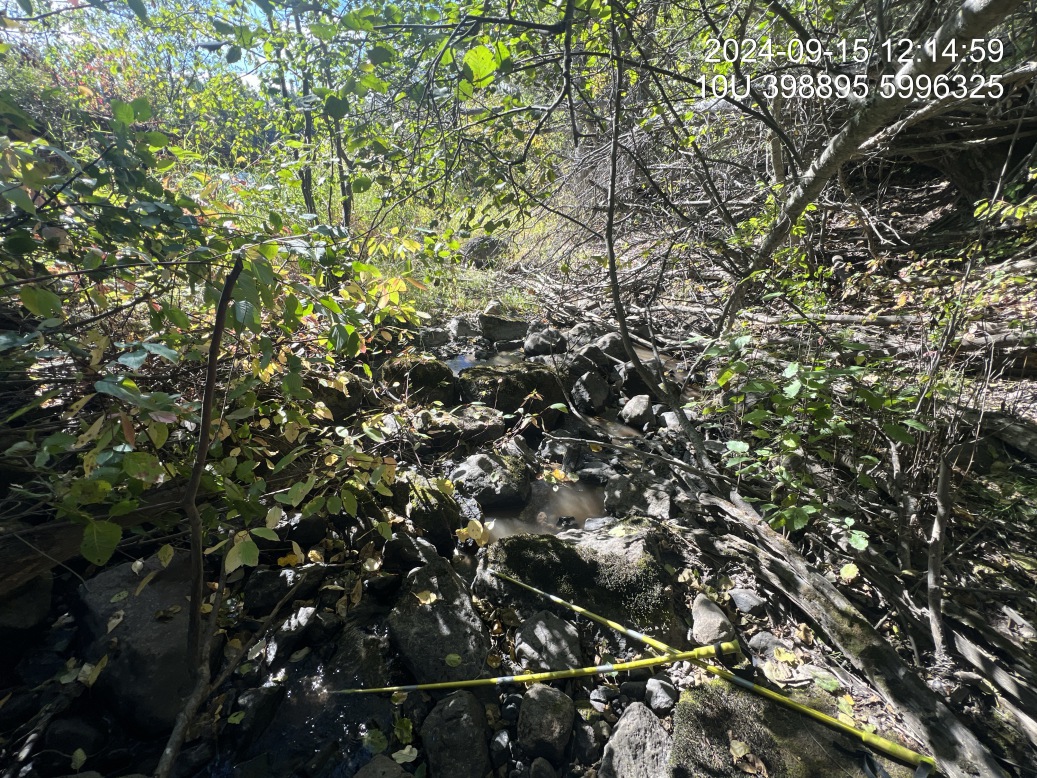
Figure 5.15: Typical habitat downstream of PSCIS crossing 199173.
my_photo2 = fpr::fpr_photo_pull_by_str(str_to_pull = 'us1')

my_caption2 = paste0('Typical habitat upstream of PSCIS crossing ', my_site, '.')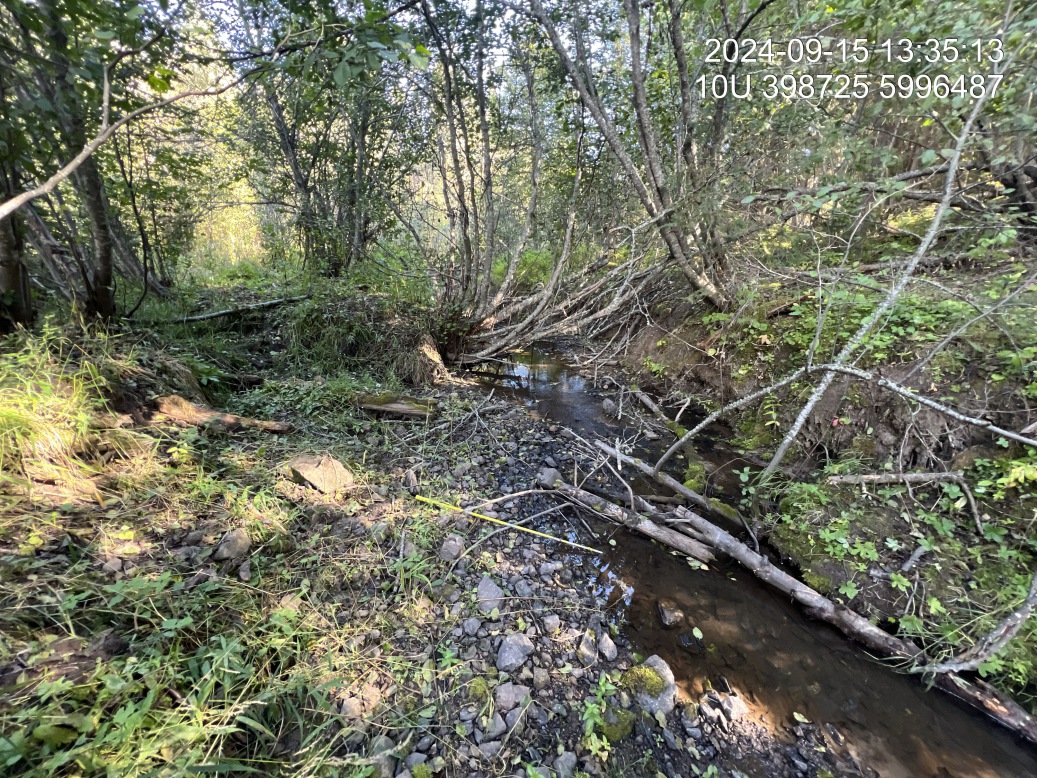
Figure 5.16: Typical habitat upstream of PSCIS crossing 199173.
my_caption <- paste0('Left: ', my_caption1, ' Right: ', my_caption2)

knitr::include_graphics(my_photo1)
knitr::include_graphics("fig/pixel.png")
knitr::include_graphics(my_photo2)
my_photo1 = fpr::fpr_photo_pull_by_str(site = my_site2, str_to_pull = 'ds_typical_1_')
my_caption1 = paste0('Typical habitat downstream of PSCIS crossing ', my_site2, '.')_ds_typical_1_k_.JPG)
Figure 5.17: Typical habitat downstream of PSCIS crossing 199174.
my_photo2 = fpr::fpr_photo_pull_by_str(site = my_site2, str_to_pull = 'us_typical_2_')

my_caption2 = paste0('Typical habitat upstream of PSCIS crossing ', my_site2, '.')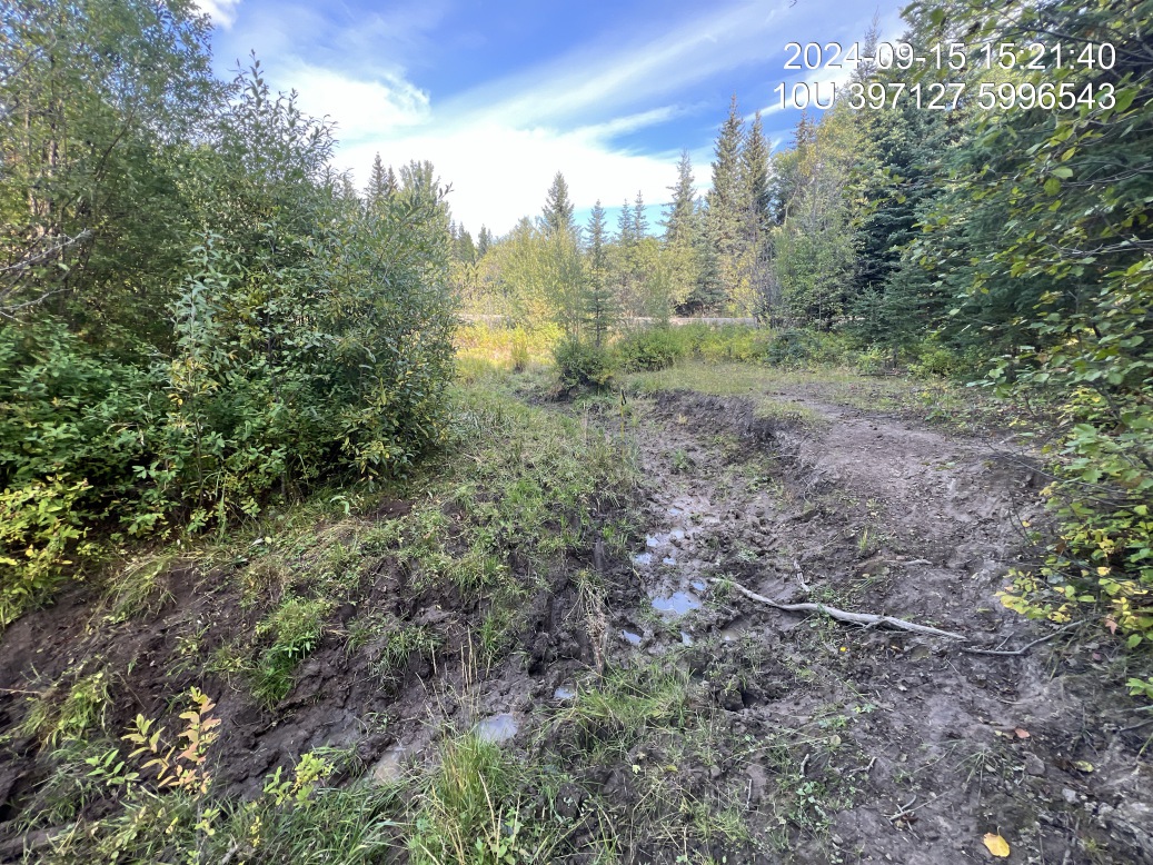
Figure 5.18: Typical habitat upstream of PSCIS crossing 199174.
my_caption <- paste0('Left: ', my_caption1, ' Right: ', my_caption2)

knitr::include_graphics(my_photo1)
knitr::include_graphics("fig/pixel.png")
knitr::include_graphics(my_photo2)