Driscoll Creek - 199267 - Appendix
Site Location
PSCIS crossing 199267 is located on Driscoll Creek, approximately 100km northwest of McBride, BC, in the Morkill River watershed group (Figure 5.50). The crossing is located 7.7km upstream of where Driscoll Creek joins the Fraser River. Situated on Highway 16, the crossing is the responsibility of the Ministry of Transportation and Infrastructure (chris_culvert_id: 1992674).
This crossing is located on the boundary of the Chun T’oh Whudujut (Ancient Forest), a Provincial Park and Protected Area within the traditional territory of the Lheidli T’enneh (Figure 5.50). The park has thousand-year-old western red cedars and a rich biodiversity of plants, mosses, lichens and fungi which can be explored through the trail network. Historically, Lheidli people would visit the stands from summer fishing camps along the upper Fraser River as well as gather medicinal plants, some of which were thought to be extinct. However, the park was not always a protected area and was initially slated for logging until a UNBC graduate student studying lichen biodiversity identified the ancient stands of western red cedars. Recognizing their ecological and cultural significance, trails were developed to highlight the cedars and advocate for their protection. Through partnerships with local hiking groups, UNBC, Lheidli T’enneh, and the Provincial Government, the Ancient Forest biodiversity assessment project has contributed to conservation efforts and tourism-based economic development in the Prince George area (“Chun t’oh Whudujut (Ancient Forest)” 2025).
Figure 5.43: Map of Driscoll Creek
Background
At PSCIS crossing 199267, Driscoll Creek is a fourth order stream and drains a high elevation watershed of approximately 34.3km2. The watershed ranges in elevation from a maximum of 1795m to 683m near the crossing (Table 5.45).
In 2023, crossing 199267 on Highway 16 was assessed with a fish passage assessment and prioritized for follow-up due to the presence of high-value habitat and a historical chinook observation documented downstream in the FISS database (MoE 2024). A habitat confirmation assessment was subsequently conducted in 2024.
Upstream of the Highway 16, rainbow trout and slimy sculpin have previously been recorded (Norris [2018] 2024; MoE 2024). Additionally, there is Fisheries and Oceans Canada stock assessment data available for Driscoll Creek presented in Table 2.1 of the background section (Fisheries and Oceans Canada n.d.).
A summary of habitat modelling outputs for the crossing are presented in Table 5.46.
fpr::fpr_table_wshd_sum(site_id = my_site) |>
  fpr::fpr_kable(caption_text = paste0('Summary of derived upstream watershed statistics for PSCIS crossing ', my_site, '.'),
           footnote_text = 'Elev P60 = Elevation at which 60% of the watershed area is above',
scroll = F)| Site | Area Km | Elev Site | Elev Min | Elev Max | Elev Median | Elev P60 | Aspect |
|---|---|---|---|---|---|---|---|
| 199267 | 34.3 | 683 | 621 | 1795 | 960 | 871 | SE |
| * Elev P60 = Elevation at which 60% of the watershed area is above |
| Habitat | Potential | Remediation Gain | Remediation Gain (%) |
|---|---|---|---|
| CH Spawning (km) | 6.9 | 1.8 | 26 |
| CH Rearing (km) | 8.2 | 2.1 | 26 |
| CO Spawning (km) | 0.0 | 0.0 | – |
| CO Rearing (km) | 0.0 | 0.0 | – |
| CO Rearing (ha) | 0.0 | 0.0 | – |
| SK Spawning (km) | 0.0 | 0.0 | – |
| SK Rearing (km) | 0.0 | 0.0 | – |
| SK Rearing (ha) | 0.0 | 0.0 | – |
| BT Rearing (km) | 12.5 | 2.1 | 17 |
| BT Spawning (km) | 8.8 | 1.7 | 19 |
| * Model data is preliminary and subject to adjustments. |
Stream Characteristics at Crossing 199267
At the time of the 2024 assessment, PSCIS crossing 199267 on Highway 16 was un-embedded, non-backwatered and ranked as barrier to upstream fish passage according to the provincial protocol (MoE 2011) (Table 5.47). The culvert had a significant 0.65m outlet drop. Photos from the 2024 assessment were limited due to the surveyor’s phone falling in the river; however, photos from the 2023 assessment can be found in Appendix - Phase 1 Fish Passage Assessment Data and Photos.
The water temperature was 6\(^\circ\)C, pH was 7.5 and conductivity was 245 uS/cm.
| Location and Stream Data |
|
Crossing Characteristics | – |
|---|---|---|---|
| Date | 2024-10-08 | Crossing Sub Type | Round Culvert |
| PSCIS ID | 199267 | Diameter (m) | 2.3 |
| External ID | – | Length (m) | 56 |
| Crew | LS | Embedded | No |
| UTM Zone | 10 | Depth Embedded (m) | – |
| Easting | 606378 | Resemble Channel | No |
| Northing | 5965782 | Backwatered | No |
| Stream | Driscoll Creek | Percent Backwatered | – |
| Road | Highway 16 | Fill Depth (m) | 1 |
| Road Tenure | MoTi | Outlet Drop (m) | 0.65 |
| Channel Width (m) | 10.6 | Outlet Pool Depth (m) | 1.25 |
| Stream Slope (%) | 0.6 | Inlet Drop | No |
| Beaver Activity | Yes | Slope (%) | 2.5 |
| Habitat Value | Medium | Valley Fill | Deep Fill |
| Final score | 37 | Barrier Result | Barrier |
| Fix type | Replace with New Open Bottom Structure | Fix Span / Diameter | 15 |
| Comments: The culvert had a deep outlet pool and a very large outlet drop. The stream was banked with a well-developed, healthy, riparian zone consisting of old-growth forest. A beaver dam was located just upstream of the culvert inlet. No photos are available because the surveyors phone fell into the stream. MoTi chris_culvert_id: 1992674 | |||
| Photos: From top left clockwise: Road/Site Card, Barrel, Outlet, Downstream, Upstream, Inlet. | |||
|
Stream Characteristics Downstream of Crossing 199267
The stream was surveyed downstream from crossing 199267 for 300m . The habitat was rated as high value for spawning and rearing. The surrounding riparian area consisted of a healthy old-growth forest on both sides of the stream. The dominant substrate was gravels with fines sub-dominant.Total cover amount was rated as moderate with large woody debris dominant. Cover was also present as small woody debris, undercut banks, and overhanging vegetation.The average channel width was 10.7m, the average wetted width was 7.5m, and the average gradient was 0.6%. Photos from the 2024 assessment were limited due to the surveyor’s phone falling in the river; however, photos from the 2023 assessment can be found in Appendix - Phase 1 Fish Passage Assessment Data and Photos.
Stream Characteristics Upstream of Crossing 199267
The stream was surveyed upstream from crossing 199267 for 600m (Figures 5.44- 5.45). The habitat was rated as high value for spawning and rearing. The stream was a low-gradient, gravel-dominated system with an extensive shrub-sedge wetland area and beaver activity in the lower 200m. Deep pools up to 1m were present throughout, influenced by abundant large woody debris contributed from the adjacent mature, primarily coniferous forest. The dominant substrate was gravels with cobbles sub-dominant.The average channel width was 8.9m, the average wetted width was 8.7m, and the average gradient was 0.5%.Total cover amount was rated as moderate with large woody debris dominant. Cover was also present as small woody debris, undercut banks, deep pools, and overhanging vegetation.
Structure Remediation and Cost Estimate
Should restoration/maintenance activities proceed, replacement of the Highway 16 crossing (199267) with a bridge (15 m span) is recommended. At the time of reporting in 2025, the cost of the work is estimated at $ 11,250,000.
Conclusion
PSCIS crossing 199267 on Highway 16 had a significant outlet drop and is a moderate priority for replacement. The habitat upstream of Highway 16 was rated as moderate value for spawning and rearing during the 2024 assessment, and fish sampling is recommended to further assess whether the crossing is inhibiting fish passage. Given the crossing’s proximity to Chun T’oh Whudujut (Ancient Forest) Provincial Park and its location within the traditional territory of the Lheidli T’enneh, restoration efforts could align with broader conservation initiatives and community engagement, increasing the likelihood of funding and project momentum.
tab_hab_summary |>
  dplyr::filter(Site %in% c(my_site)) |>
  fpr::fpr_kable(caption_text = paste0("Summary of habitat details for PSCIS crossing ", my_site, "."),
scroll = F) | Site | Location | Length Surveyed (m) | Average Channel Width (m) | Average Wetted Width (m) | Average Pool Depth (m) | Average Gradient (%) | Total Cover | Habitat Value |
|---|---|---|---|---|---|---|---|---|
| 199267 | Downstream | 300 | 10.7 | 7.5 | 0.5 | 0.6 | moderate | high |
| 199267 | Upstream | 600 | 8.9 | 8.7 | 0.7 | 0.5 | moderate | high |
my_photo1 = fpr::fpr_photo_pull_by_str(str_to_pull = 'us_wetland')

my_caption1 = paste0('Typical habitat upstream of PSCIS crossing ', my_site, '.')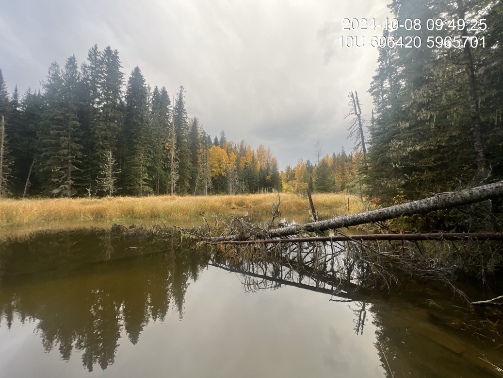
Figure 5.44: Typical habitat upstream of PSCIS crossing 199267.
my_photo2 = fpr::fpr_photo_pull_by_str(str_to_pull = 'us_typical_1_')

my_caption2 = paste0('Typical habitat upstream of PSCIS crossing ', my_site, '.')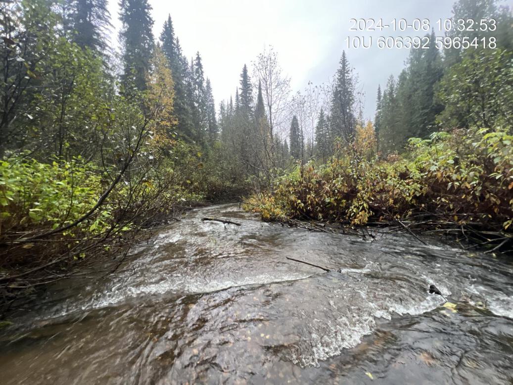
Figure 5.45: Typical habitat upstream of PSCIS crossing 199267.
my_caption <- paste0('Left: ', my_caption1, ' Right: ', my_caption2)

knitr::include_graphics(my_photo1)
knitr::include_graphics("fig/pixel.png")
knitr::include_graphics(my_photo2)