Burnt Cabin Creek - 199171 & 7622 - Appendix
Site Location
PSCIS crossings 199171 and 7622 are located on Burnt Cabin Creek which flows into the northern side of Fraser Lake, BC, approximately 8km northwest of the Nadleh Whut’en First Nations community, in the Francois Lake watershed group (Figure 5.1). The stream name Burnt Cabin Creek is the local name for the waterway as it is not named
within the freshwater atlas. Crossing 199171 is located 50m upstream of Fraser Lake, on Gala Bay Road - and approximately 275m further upstream, PSCIS crossing 7622 is located on Stella Road. Both crossings are the responsibility of the Ministry of Transportation and Infrastructure (chris_culvert_id: 1790951 and 1794196). The recently completed Coastal Gaslink pipeline crosses the stream approximately 500m upstream of Stella Road.
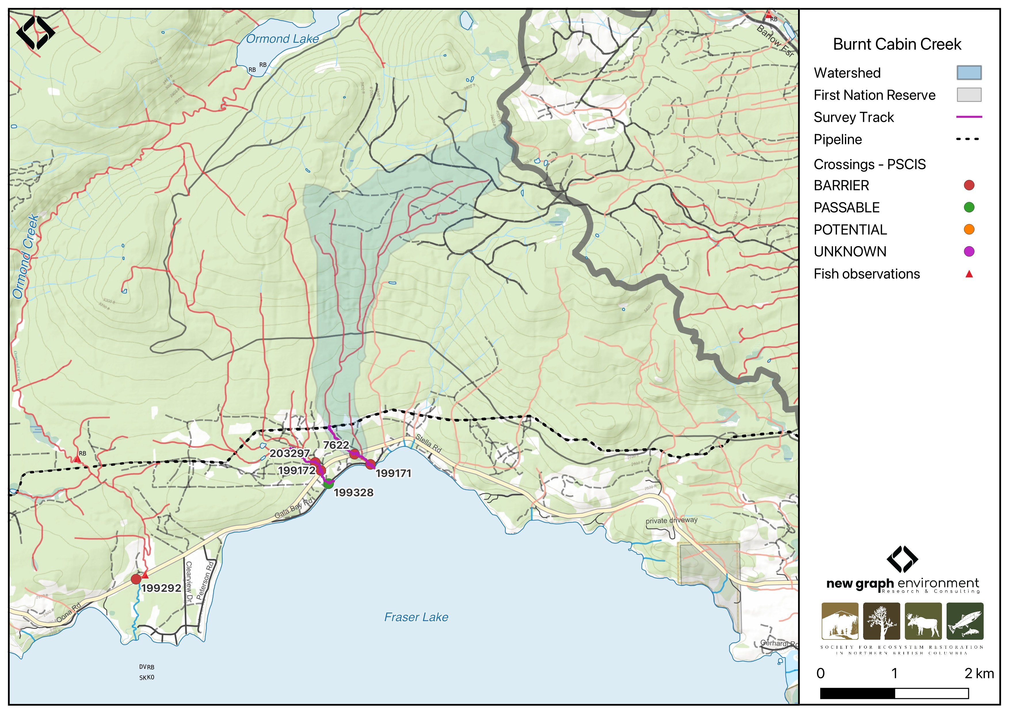
Figure 5.1: Map of Burnt Cabin Creek
Background
At the location of these crossings, Burnt Cabin Creek is a third order stream and drains a watershed of approximately 4.5km2. The watershed ranges in elevation from a maximum of 1237m to 683m near the lower crossing (Table 5.1).
PSCIS crossing 7622 was first assessed with a fish passage assessment in 2004 under the project name “2004 BC Conservation Corp Assessments, DRV” (MoE 2023). Background documentation could not be sourced. Both crossings 199171 and 7622 were reassessed in 2023 and prioritized for follow-up due to the presence of a significant amount of modelled habitat as well as habitat rated as medium value during the 2004 assessment. A habitat confirmation assessment encompassing both sites was conducted in 2024. No fisheries information is documented for the stream; however, downstream in Fraser Lake, white sturgeon, rainbow trout, kokanee, sockeye salmon, chinook salmon, bull trout, dolly varden, and other species have been previously recorded (Norris [2018] 2024; MoE 2024). During the site visit to Gala Bay Road, an adjacent landowner reported observing adult sockeye along the shoreline near the confluence of the stream and Fraser Lake in the past. They also mentioned that the stream flows year-round, even in dry years, fed by a spring emerging from the mountainside at the headwaters and that the stream below Gala Bay Road had been diverted to accommodate a driveway for a recreational property.
A summary of habitat modelling outputs for the crossing are presented in Table 5.2.
fpr::fpr_table_wshd_sum(site_id = my_site) |>
  fpr::fpr_kable(caption_text = paste0('Summary of derived upstream watershed statistics for PSCIS crossing ', my_site, '.'),
           footnote_text = 'Elev P60 = Elevation at which 60% of the watershed area is above',
scroll = F)| Site | Area Km | Elev Site | Elev Min | Elev Max | Elev Median | Elev P60 | Aspect |
|---|---|---|---|---|---|---|---|
| 199171 | 4.5 | 683 | 675 | 1237 | 942 | 881 | SSW |
| * Elev P60 = Elevation at which 60% of the watershed area is above |
| Habitat | Potential | Remediation Gain | Remediation Gain (%) |
|---|---|---|---|
| CH Spawning (km) | 0.0 | 0.0 | – |
| CH Rearing (km) | 0.0 | 0.0 | – |
| CO Spawning (km) | 0.0 | 0.0 | – |
| CO Rearing (km) | 0.0 | 0.0 | – |
| CO Rearing (ha) | 0.0 | 0.0 | – |
| SK Spawning (km) | 0.0 | 0.0 | – |
| SK Rearing (km) | 0.0 | 0.0 | – |
| SK Rearing (ha) | 0.0 | 0.0 | – |
| BT Rearing (km) | 2.3 | 0.2 | 9 |
| BT Spawning (km) | 0.0 | 0.0 | – |
| * Model data is preliminary and subject to adjustments. |
Aerial Imagery
An aerial survey was conducted with a remotely piloted aircraft and the resulting imagery was processed into an orthomosaic available to view and download in Figure 5.2.
viewer_url <- '<iframe src="https://viewer.a11s.one/?cog=https://imagery-uav-bc.s3.amazonaws.com/fraser/nechacko/2024/199171_burnt_cabin_gala/odm_orthophoto/odm_orthophoto.tif" scrolling="no" title="UAV Viewer" width="100%" height="600" frameBorder="0"></iframe>'

knitr::asis_output(viewer_url)
my_photo = 'fig/pixel.png'
my_caption = paste0('Orthomosaic of PSCIS crossing ', my_site, '.')
knitr::include_graphics(my_photo, dpi = NA)Figure 5.2: Orthomosaic of PSCIS crossing 199171.
Stream Characteristics at Crossings 199171 and 7622
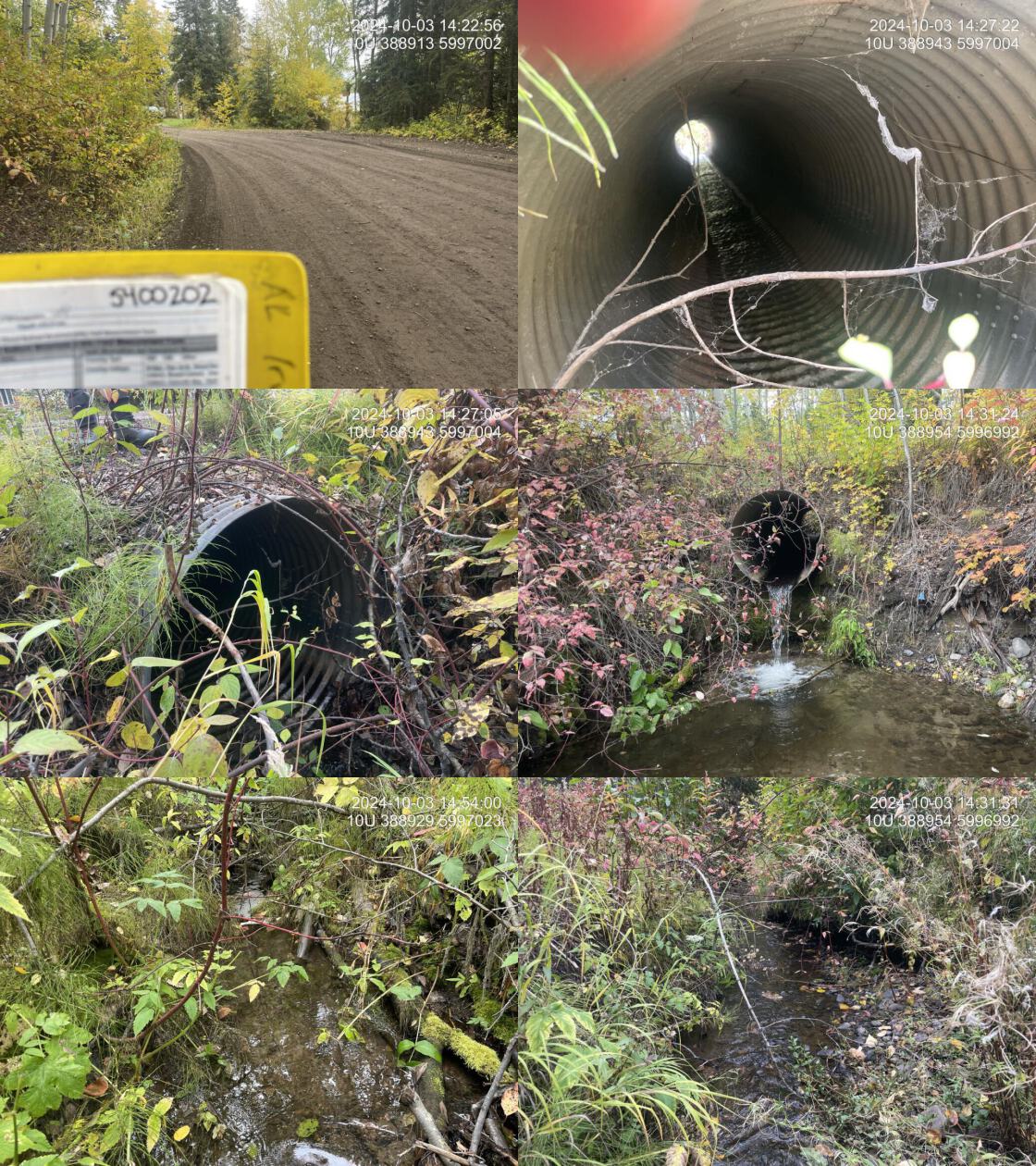
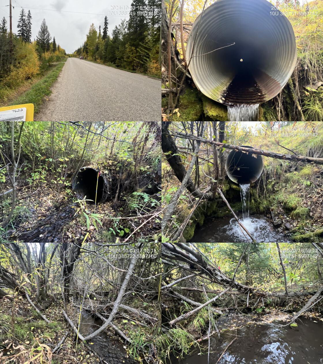
During the 2023 and 2024 assessments, both PSCIS crossings 199171 and 7622 were un-embedded, non-backwatered and ranked as a barrier to upstream fish passage according to the provincial protocol (MoE 2011) (Tables 5.3 - 5.4). Crossing 199171 had a 0.9m outlet drop, while crossing 7622 had a 1.2m outlet drop.
Water temperature was 5\(^\circ\)C, pH was 8.5 and conductivity was 333 uS/cm.
| Location and Stream Data |
|
Crossing Characteristics | – |
|---|---|---|---|
| Date | 2024-10-03 | Crossing Sub Type | Round Culvert |
| PSCIS ID | 199171 | Diameter (m) | 1.05 |
| External ID | – | Length (m) | 12 |
| Crew | LS | Embedded | No |
| UTM Zone | 10 | Depth Embedded (m) | – |
| Easting | 388944 | Resemble Channel | No |
| Northing | 5997001 | Backwatered | No |
| Stream | Burnt Cabin Creek | Percent Backwatered | – |
| Road | Gala Bay Road | Fill Depth (m) | 0.5 |
| Road Tenure | MOTI | Outlet Drop (m) | 0.9 |
| Channel Width (m) | 3.1 | Outlet Pool Depth (m) | 0.35 |
| Stream Slope (%) | 3 | Inlet Drop | No |
| Beaver Activity | No | Slope (%) | 7 |
| Habitat Value | Medium | Valley Fill | Deep Fill |
| Final score | 36 | Barrier Result | Barrier |
| Fix type | Replace with New Open Bottom Structure | Fix Span / Diameter | 15 |
| Comments: The local name of the stream is Burnt Cabin Creek. A large outlet drop and a heavily eroded outlet pool indicated the culvert was undersized. The stream provided complex habitat with abundant cover. The crossing was located on a low-traffic dirt road with minimal fill, making replacement relatively straightforward. An adjacent landowner reported observing adult sockeye along the shoreline near the confluence of the stream and Fraser Lake in previous years. They also said the stream is reported to flow year-round, even in dry conditions, fed by a spring at the headwaters, and that the section of stream below Gala Bay Road has been diverted to accommodate a driveway for a recreational property. MoTi chris_culvert_id: 1790951 | |||
| Photos: From top left clockwise: Road/Site Card, Barrel, Outlet, Downstream, Upstream, Inlet. | |||
|
| Location and Stream Data |
|
Crossing Characteristics | – |
|---|---|---|---|
| Date | 2024-10-03 | Crossing Sub Type | Round Culvert |
| PSCIS ID | 7622 | Diameter (m) | 1.15 |
| External ID | – | Length (m) | 30 |
| Crew | AI SC | Embedded | No |
| UTM Zone | 10 | Depth Embedded (m) | – |
| Easting | 388735 | Resemble Channel | No |
| Northing | 5997152 | Backwatered | No |
| Stream | Burnt Cabin Creek | Percent Backwatered | – |
| Road | Stella Road | Fill Depth (m) | 2.2 |
| Road Tenure | MoTI | Outlet Drop (m) | 1.15 |
| Channel Width (m) | 2 | Outlet Pool Depth (m) | 0.43 |
| Stream Slope (%) | 5 | Inlet Drop | No |
| Beaver Activity | No | Slope (%) | 5 |
| Habitat Value | Medium | Valley Fill | Deep Fill |
| Final score | 42 | Barrier Result | Barrier |
| Fix type | Replace with New Open Bottom Structure | Fix Span / Diameter | 15 |
| Comments: The culvert is undersized for current flow volumes, as indicated by the 1.15m outlet drop. The stream provided high-value spawning and rearing habitat. The local name of the stream is Burnt Cabin Creek. A landowner adjacent to the crossing downstream on Gala Bay Road (PSCIS 199171) reported observing adult sockeye along the shoreline near the confluence with Fraser Lake in past years, and noted that the stream flows year-round, even in dry conditions, fed by a spring at the headwaters. Habitat confirmations were completed upstream, downstream, and below Gala Bay Road. MoTi chris_culvert_id: 1794196 | |||
| Photos: From top left clockwise: Road/Site Card, Barrel, Outlet, Downstream, Upstream, Inlet. | |||
|
Stream Characteristics Downstream of Crossing 199171
The stream was surveyed downstream from crossing 199171 for 50m (Figure 5.3). The stream was highly channelized due to residential properties on both sides. The habitat was rated as medium with minimal cover and few pools suitable for fish, but gravels were present for spawning. The average channel width was 2.4m, the average wetted width was 1.4m, and the average gradient was 1.3%.Total cover amount was rated as moderate with overhanging vegetation dominant. Cover was also present as small woody debris and undercut banks.The dominant substrate was gravels with fines sub-dominant.
Stream Characteristics Upstream of Crossing 199171 and Downstream of Crossing 7622
The stream was surveyed upstream from crossing 199171 for 275m , all the way to crossing 7622 on Stella Road (Figure 5.4). The dominant substrate was gravels with cobbles sub-dominant.Total cover amount was rated as moderate with small woody debris dominant. Cover was also present as large woody debris, undercut banks, and overhanging vegetation.The average channel width was 2.4m, the average wetted width was 1.2m, and the average gradient was 4.5%. The habitat was rated as medium value, with good flow and abundant gravels, flowing through several private properties with newly established quad and foot traffic trails. Pools were limited and predominantly shallow.
Stream Characteristics Upstream of Crossing 7622
The stream was surveyed upstream from crossing 7622 for 500m to the pipeline right of way (Figure 5.5). The habitat was rated as high value with relatively steep gradients and abundant functional large woody debris creating steps and pools 20 – 30cm deep. In some sections, the stream widened and became shallow, with abundant gravels suitable for spawning. Overhead cover was extensive. Near the upper end of the site, the forest had been cleared for pipeline use, resulting in significant bank erosion and riparian removal (Figure 5.6). The dominant substrate was gravels with fines sub-dominant.The average channel width was 3.5m, the average wetted width was 1.4m, and the average gradient was 7%.Total cover amount was rated as abundant with large woody debris dominant. Cover was also present as small woody debris, undercut banks, and overhanging vegetation.
Structure Remediation and Cost Estimate
Should restoration/maintenance activities proceed, replacement of the Gala Bay Road crossing (199171) with a 4.5m open bottom structure is recommended. At the time of reporting in 2025, the cost of the work is estimated at $1,500,000. As the stream width is relatively narrow installation of a streambed simulation culvert could be considered with costs estimated as significantly lower than a bridge ($400,000).
Should restoration/maintenance activities proceed, replacement of the Stella Road crossing (7622) with a bridge (15 m span) is recommended. This culvert had a 1.2m outlet drop, very likely inhibiting fish passage. At the time of reporting in 2025, the cost of the work is estimated at $3,000,000.
Conclusion
Burnt Cabin Creek is a small stream that flows into Fraser Lake. The historic observation of an adult sockeye along the shoreline of the lake near the stream’s confluence with Fraser Lake combined with the stream’s apparently perennial and groundwater-influenced flow, highlights the site may be located near sockeye shoreline spawning habitat, indicating high ecological and cultural importance for the area. The downstream crossing on Gala Bay Road had a 0.9m outlet drop, while the Stella Road crossing had a 1.2m outlet drop, both of which are likely completely inhibiting upstream fish passage for all life stages of fish that would be present. Both crossings are considered high priorities for replacement with the acquisition of an engineering design and replacement cost estimate recommended for the downstream crossing. Fish sampling is recommended to determine fish presence and community composition upstream and downstream of both the Gala Bay Road site as well as the Stella Road crossing.
tab_hab_summary |>
  dplyr::filter(Site %in% c(my_site, my_site2)) |>
  fpr::fpr_kable(caption_text = paste0("Summary of habitat details for PSCIS crossings ", my_site, " and ", my_site2, "."),
scroll = F) | Site | Location | Length Surveyed (m) | Average Channel Width (m) | Average Wetted Width (m) | Average Pool Depth (m) | Average Gradient (%) | Total Cover | Habitat Value |
|---|---|---|---|---|---|---|---|---|
| 7622 | Upstream | 500 | 3.5 | 1.4 | 0.2 | 7.0 | abundant | high |
| 199171 | Downstream | 50 | 2.4 | 1.4 | 0.1 | 1.3 | moderate | medium |
| 199171 | Upstream | 275 | 2.4 | 1.2 | 0.1 | 4.5 | moderate | medium |
my_photo1 = fpr::fpr_photo_pull_by_str(str_to_pull = 'ds_typical_2_')

my_caption1 = paste0('Typical habitat downstream of PSCIS crossing ', my_site, '.')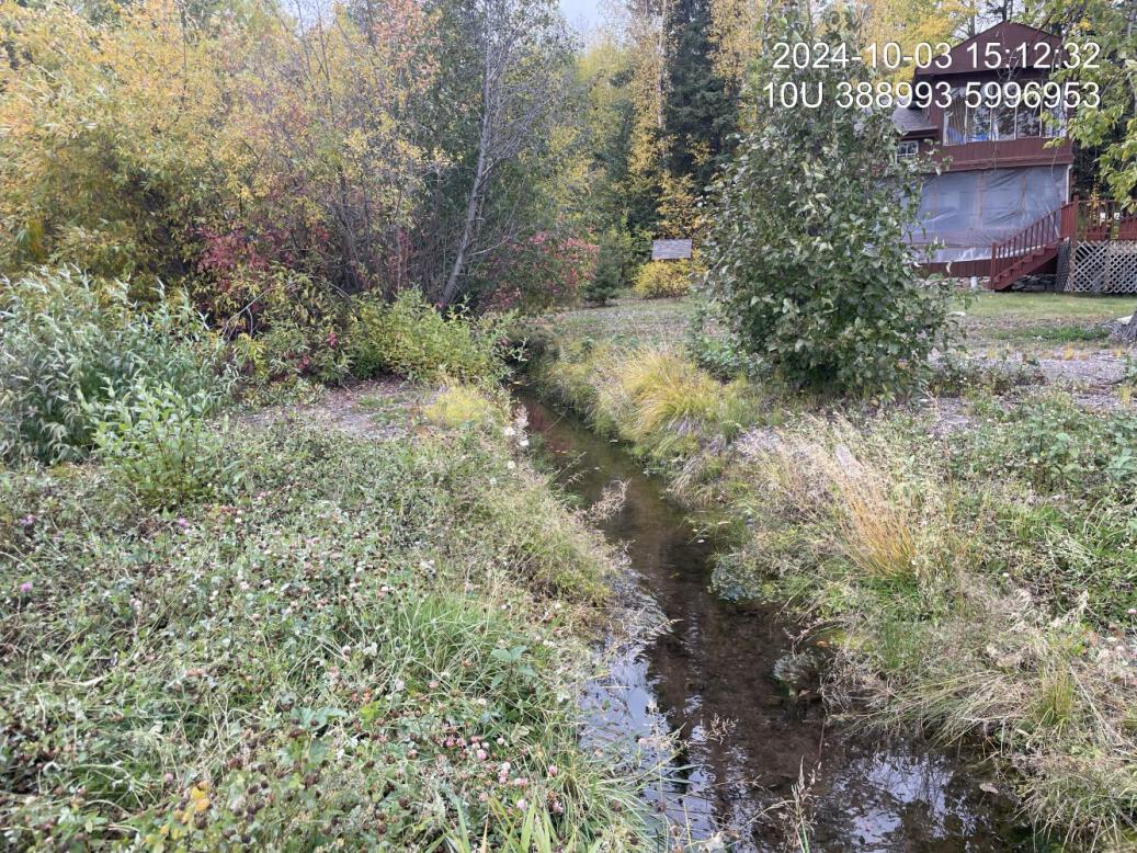
Figure 5.3: Typical habitat downstream of PSCIS crossing 199171.
my_photo2 = fpr::fpr_photo_pull_by_str(str_to_pull = 'us_typical_2')

my_caption2 = paste0('Typical habitat upstream of PSCIS crossing ', my_site, ' and downstream of PSCIS crossing ', my_site2, '.')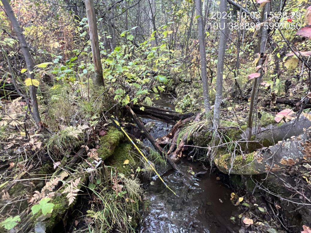
Figure 5.4: Typical habitat upstream of PSCIS crossing 199171 and downstream of PSCIS crossing 7622.
my_caption <- paste0('Left: ', my_caption1, ' Right: ', my_caption2)

knitr::include_graphics(my_photo1)
knitr::include_graphics("fig/pixel.png")
knitr::include_graphics(my_photo2)
my_photo1 = fpr::fpr_photo_pull_by_str(site = my_site2, str_to_pull = 'us')
my_caption1 = paste0('Typical habitat upstream of PSCIS crossing ', my_site2, '.')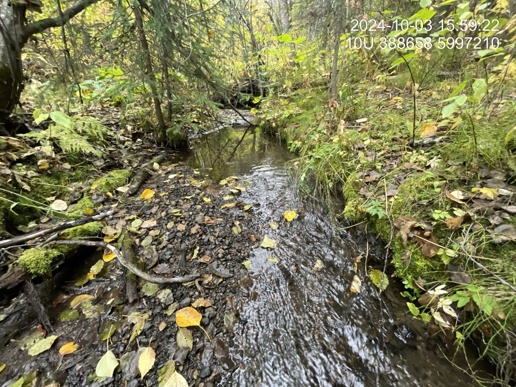
Figure 5.5: Typical habitat upstream of PSCIS crossing 7622.
my_photo2 = fpr::fpr_photo_pull_by_str(site = my_site2, str_to_pull = 'pipeline')

my_caption2 = paste0('Bank erosion and riparian removal at the pipeline upstream of crossing ', my_site2, '.')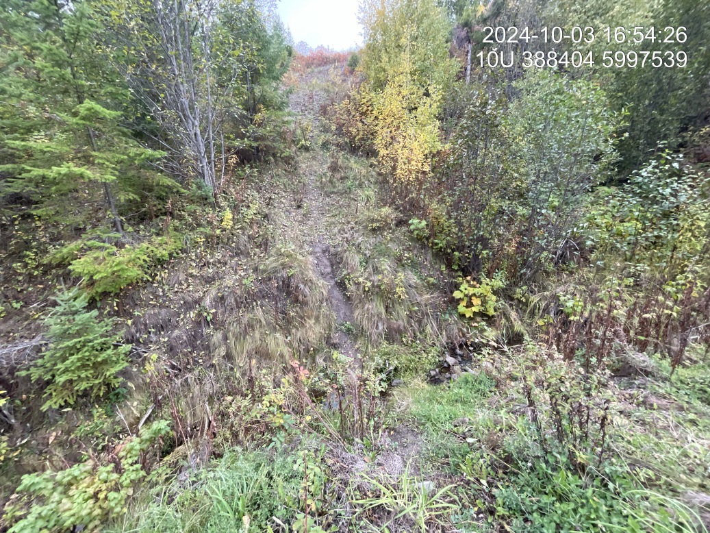
Figure 5.6: Bank erosion and riparian removal at the pipeline upstream of crossing 7622.
my_caption <- paste0('Left: ', my_caption1, ' Right: ', my_caption2)

knitr::include_graphics(my_photo1)
knitr::include_graphics("fig/pixel.png")
knitr::include_graphics(my_photo2)